Stralsund — Hanseatic port town on the Strelasund, Germany
Stralsund is a historic port city in Mecklenburg-Western Pomerania on the Strelasund, noted for its Hanseatic past, Brick Gothic architecture, museums and its role as gateway to the island of Rügen.
Overview
Stralsund is a coastal city in northern Germany with a long maritime history and a compact medieval centre. It lies on the southern shore of the Strelasund, the narrow sound that separates the mainland from the island of Rügen. Historically a trading port, Stralsund retains a concentrated set of brick-built public and private buildings from the medieval and early modern periods and functions today as an administrative, cultural and tourist centre in Mecklenburg-Western Pomerania.
Image gallery
10 Images


Geography and setting
The town faces the Strelasund channel on the Strelasund and sits where coastal lagoons, shallow bays and peninsulas shape the Baltic shoreline. The Strelasund itself is part of the larger Baltic Sea system; the sound separates the island described here as the island of Rügen from the adjacent mainland. Because of this position Stralsund has served as a local transport hub linking ferry, road and, more recently, fixed-crossing connections to Rügen.
Historical development
Stralsund developed as a merchant town in the medieval period and in 1293 joined the Hanseatic League, a network of trading cities across the Baltic and North Sea. Membership stimulated the construction of large brick warehouses, a substantial town hall and imposing parish churches. Over centuries the town experienced changing political ties and economic fortunes; in the 20th century it was part of the German Democratic Republic from 1949 until reunification. Its Hanseatic legacy remains central to local identity and urban layout (Hanseatic League).
Architecture and UNESCO recognition
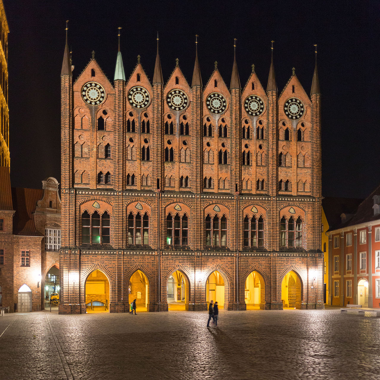
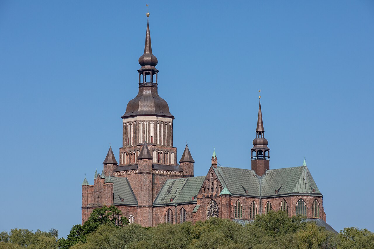
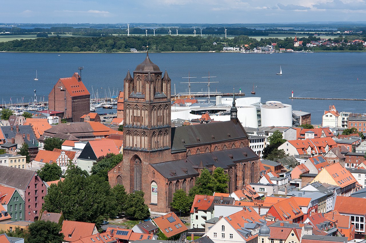
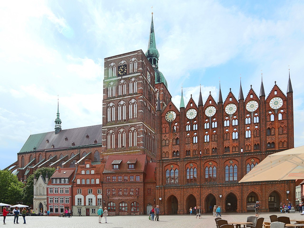
Stralsund's old town is particularly known for Brick Gothic architecture: tall church towers, stepped gables on merchant houses and richly modelled civic buildings. The historic centre, together with the town of Wismar, is recognised for its outstanding medieval urban fabric and is protected as a World Heritage site by UNESCO. The street plan, waterfronts and preserved monuments provide a clear sense of the town's development from the Middle Ages to modern times.
Museums, science and culture
The city hosts important cultural institutions that interpret maritime and natural history, including a major oceanographic and aquarium complex that examines the Baltic and Atlantic marine environments. Local museums present the town's Hanseatic past, seafaring, and everyday urban life. Educational and research facilities, including a local university of applied sciences, contribute to academic and technical activity in the town.
Economy and transport
Stralsund's economy blends port-related functions, light industry, public services, maritime research and a significant tourism sector. The harbour and nearby ferry and bridge connections serve freight and passenger traffic to the island of Rügen. As a gateway to popular beaches and natural reserves, the city benefits from seasonal visitor flows while maintaining industrial and service employment for residents.
Environment and leisure
The coast and the adjacent coastal lagoons form an important environment for seabirds, marine life and traditional fisheries. Protected areas such as the Western Pomerania lagoon landscape lie close by and attract nature tourism, birdwatching and outdoor recreation. Boat trips on the Strelasund and coastal walks offer accessible ways to explore the region's maritime landscape.
Tourism and events
Visitors come to see the UNESCO-listed old town, visit maritime exhibitions and use Stralsund as a base for excursions to beaches and nature reserves on Rügen. The town stages cultural events, markets and exhibitions that celebrate its maritime and Hanseatic traditions and support a year-round programme of exhibitions, concerts and local festivals.
Further information
For practical visitor information, local administration and tourism services consult official resources on the state and regional level: state information, coastal guides for the Strelasund and Baltic Sea, services for the island and the mainland transport links. Historical overviews and research on the town's Hanseatic connections may be found through sources devoted to the Hanseatic League.
- Key features: medieval port layout, Brick Gothic monuments and a concentrated historic centre.
- Access: road, rail and sea links; serves as a principal gateway to the island of Rügen.
- Visitor highlights: waterfront promenades, maritime museums, and nearby coastal reserves for nature tourism.


Geography
Regional planning
Together with Greifswald, Stralsund forms one of the four regional centres of Mecklenburg-Vorpommern. In the regional development programmes for the state and in the Vorpommern planning association, close cooperation is envisaged between Stralsund and its surrounding area and Greifswald. Both Hanseatic cities had a combined population of around 118,000, while the intervening administrative districts of Miltzow and Landhagen and Grimmen had a combined population of around 27,000 (2018). The nearest conurbations relevant for
the city region are the Rostock regiopolis and the metropolitan regions of Szczecin in the east, Berlin in the southeast, Hamburg in the west and Copenhagen-Malmö in the north.
City breakdown
After the abolition of the fortress character of the old town in 1869, the surrounding areas were settled.
The area of Stralsund is divided into the following urban areas and districts:
| No. | City area | District | Inhabitants |
| 01 | Old Town | 6.090 | |
| 011 | Old Town | Old Town | 5.775 |
| 012 | Old Town | Harbour Island | 26 |
| 013 | Old Town | Bastion Belt | 289 |
| 02 | Knieper | 25.270 | |
| 021 | Knieper | Kniepervorstadt | 6.179 |
| 022 | Knieper | Kneeper North | 6.677 |
| 023 | Knieper | Kneeper West | 12.414 |
| 03 | Tribseer | 10.268 | |
| 031 | Tribseer | Tribseer suburb | 5.366 |
| 032 | Tribseer | Tribsee estate | 3.484 |
| 033 | Tribseer | Tribsee meadows | 1.292 |
| 034 | Tribseer | Schramm's mill | 126 |
| 04 | Franconia | 6.732 | |
| 041 | Franconia | Frankenvorstadt | 5.335 |
| 042 | Franconia | Dänholm | 187 |
| 043 | Franconia | Franconia center | 417 |
| 044 | Franconia | Frankensiedlung | 793 |
| 05 | South | 4.166 | |
| 051 | South | Andershof | 3.521 |
| 052 | South | Devin | 571 |
| 053 | South | Voigdehagen | 74 |
| 06 | Lüssow mountain | 220 | |
| 07 | Langendorf Mountain | 299 | |
| 08 | Greenhufe | 6.565 | |
| 081 | Greenhufe | City Paddock | 321 |
| 082 | Greenhufe | Vogelsang | 2.541 |
| 083 | Greenhufe | Green Valley Fourth of July | 3.630 |
| 084 | Greenhufe | Freienlande | 73 |
The foundation stone for the Knieper West I residential area was laid on 26 August 1964. It followed the Knieper Nord district as the second prefabricated housing area in the city. In January 1976, construction began on the first apartment block in the Knieper West III residential area. The last residential block there for the time being was built in 1981; it was followed in 1989 by two "cube houses" for housing suitable for the elderly.
The town also owns estates in the surrounding area and on the islands of Rügen, Hiddensee and Ummanz.
Neighboring communities
Many of the formerly smaller villages in the area, such as Parow, Prohn, Wendorf (OT Neu Lüdershagen) or Negast, have grown strongly since 1990 due to the influx of people from Stralsund or those working in Stralsund.
The towns of Barth, Grimmen and Ribnitz-Damgarten are also in the immediate vicinity of Stralsund, while the city of Greifswald is a good 30 km south-east of Stralsund.
Climate
The annual precipitation is 656 mm and is thus comparatively low; it falls into the lower third of the values recorded in Germany. The driest month is February, the most precipitation falls in July: in this month 2.1 times more precipitation falls than in February. Precipitation varies moderately.
Landscapes, elevations, waters
The city is located on the Strelasund, a strait of the Baltic Sea. The geographical proximity to the island of Rügen earned Stralsund the name Gateway to the Island of Rügen. There is both a causeway and bridge connecting the city and the island - the Rügendamm across the island of Dänholm to Altefähr - and a bridge, the Rügenbrücke; both connections form the only fixed Strelasund crossings. Stralsund is close to the National Park Vorpommersche Boddenlandschaft with its great biodiversity.
Stralsund's urban area includes a city forest and three city ponds (Knieperteich, Frankenteich and Moorteich). The three ponds and the Strelasund gave the original settlement area and historical centre of the city, now called the Old Town, a protected island location.
The highest elevation in the city is the Galgenberg at the western entrance to the city; the hospital church of the Krankenhaus West has stood on this spot since 1912.

History
→ Main article: History of the Hanseatic City of Stralsund
Name
The settlement of Strale has been known since the 10th century. Stralesund as a town name was first mentioned in a document in 1240. The Strelasund is an inlet of the Baltic Sea.
Since 1990, the city has been preceded by the name Hansestadt (Hanseatic City) before its name Stralsund.
Middle Ages until 1900
After the settlement in the course of the German settlement in the East, Stralsund received the town charter according to the Rostock and Lübeck model from the Rügen prince Wizlaw I on 31 October 1234. The area had been settled by Slavs, which also explains its Slavic name component Stral (stral means arrow or spearhead, -sund in Germanic languages stands for a separating narrowness and here means the Strelasund).
Stralsund quickly became an important trading town in the Baltic region, mainly due to settlers from Westphalia. After the extinction of the principality of Rügen in 1325, the city belonged to Pomerania-Wolgast. In the 14th century it was the most important Hanseatic city in the southern Baltic region after Lübeck. Numerous armed conflicts with the rulers of Denmark culminated in the Peace of Stralsund in 1370. After the decline of the Hanseatic League, Stralsund's importance decreased. However, the city continued to live mainly from long-distance and local trade as well as shipbuilding.
As early as 1525, the majority of Stralsund's citizens converted to the Protestant faith. The city was thus the pacemaker of the Reformation in northern Germany.
During the Thirty Years' War Stralsund withstood the siege by Wallenstein's troops with the help of Sweden and Denmark; a period of almost 200 years of belonging to the Kingdom of Sweden as part of Swedish Pomerania followed. In 1815 Stralsund came to Prussia and became the seat of a government district with five counties.
1900 until today
After the First World War Stralsund briefly experienced violent unrest until a bourgeois municipal government was established in 1919; this was dissolved by the National Socialists in 1933. In 1939, 1,287 patients were deported from the Stralsund State Sanatorium. The deportees became victims of infanticide at various locations, including the Piaśnica massacre. On 1 May 1945 Stralsund was occupied by the Red Army; after the Second World War Stralsund was part of the Soviet occupied zone of Germany in 1945.
During the time of the German Democratic Republic (GDR), numerous prefabricated housing estates were built in the city, but the historic old town centre fell into disrepair. Economically, the city lived mainly from shipbuilding at the Volkswerft Stralsund, the ships for the Soviet Union were partly completed in 10-day intervals.
After the political turnaround, Stralsund became a model town for urban development funding in 1990. The historic city centre with the old town harbour was thoroughly redeveloped with the help of the programmes for urban development promotion and urban monument protection. The residential environment of the prefabricated housing estates Grünhufe and Knieper was also improved within the framework of the programmes "Upgrading", "Urban Redevelopment East" and "The Socially Integrative City", and a housing deconstruction was initiated.
Since 2002, Stralsund's old town, together with that of Wismar, has been a UNESCO World Heritage Site, under the name Historic Old Towns of Stralsund and Wismar. In the course of this, there has been a great surge of investment in monuments and infrastructure, which has boosted tourism.
Economically, there were major challenges after the reunification, which cause considerable problems in the structurally weak region. The resulting structural change is gradually leading to more stable population and labour market conditions. Thus, the population and employment figures in Stralsund have been rising continuously for some time.
In the course of the administrative district reform in 2011, the previously independent city of Stralsund and the administrative districts of Rügen and Nordvorpommern became part of the new administrative district of Vorpommern-Rügen with its administrative seat in Stralsund.
On 1 August 2016, Stralsund was awarded the designation of state-recognised resort. The districts Knieper West, Franken Mitte, Vogelsang and Grünthal-Viermorgen are excluded from this.
Street names and their meaning
The street names of Stralsund often reflect historical events.
Stralsund city fortifications
→ Main article: Stralsund city fortifications
Stralsund had the status of a fortress until 1871, which helped the city survive many wars. In addition to ten city gates, of which only the Kniepertor and the Kütertor have been preserved, the city ponds and dams were also built. The third town gate still preserved after the defortification, the Semlow Gate, damaged in the Second World War, was blown up in 1960.
Population development
In 1989, the population of the city of Stralsund peaked at over 75,000. Afterwards, the number of inhabitants dropped again due to the strong structural changes. After the political change in the GDR in 1989/1990, the city lost well over 15,000 inhabitants until 2008. For some years, however, a turnaround has been noticeable - the decline initially slowed down, and for 2012 there was a slight increase in the number of inhabitants again for the first time. Stralsund was also able to record this in the following years, so that the population now stands at 58,241.
The following overview shows the population figures according to the respective territorial status. Up to 1833, these are mostly estimates, thereafter census results or official updates by the respective statistical offices or the city administration itself. From 1843 onwards, the data refer to the "resident population", from 1925 onwards to the resident population and since 1966 to the "population at the place of the main residence".
|
|
|
Until the beginning of the 17th century Stralsund was the most populous city of the Duchy of Pomerania, larger than the capital Stettin.


Questions and answers
Q: Where is Stralsund located?
A: Stralsund is located in the state of Mecklenburg-Western Pomerania, Germany, on the south coast of the Strelasund.
Q: What is the Strelasund?
A: The Strelasund is a sound of the Baltic Sea that separates the island of Rügen from the mainland.
Q: When did Stralsund become a member of the Hanseatic League?
A: Stralsund became a member of the Hanseatic League in 1293.
Q: What was the German Democratic Republic?
A: The German Democratic Republic was the official name of East Germany, which existed from 1949 until German reunification in 1990.
Q: Was Stralsund part of the German Democratic Republic?
A: Yes, Stralsund was part of the German Democratic Republic from 1949 until German reunification in 1990.
Q: What is the significance of Stralsund's membership in the Hanseatic League?
A: The Hanseatic League was a powerful economic alliance of medieval cities, and Stralsund's membership in the league contributed to the town's economic and political importance.
Q: How was Stralsund affected by German reunification in 1990?
A: Stralsund became part of the reunified Germany in 1990, along with the rest of the former German Democratic Republic. This brought significant changes to the town's economy and society, as it became part of a larger, unified nation.
Related articles
Author
AlegsaOnline.com Stralsund — Hanseatic port town on the Strelasund, Germany Leandro Alegsa
URL: https://en.alegsaonline.com/art/94167
Sources
- destatis.de : "Alle politisch selbständigen Gemeinden mit ausgewählten Merkmalen am 31.12.2018 (4. Quartal)" · web.archive.org
- laiv-mv.de : "Bevölkerungsstand der Kreise, Ämter und Gemeinden in Mecklenburg-Vorpommern 31.12.2016"
- britannica.com : EB-Stralsund