Stonehenge — Prehistoric stone circle and ritual landscape in Wiltshire
Stonehenge is a prehistoric stone circle and earthwork on Salisbury Plain, England. Built 3100–1550 BC, it is a World Heritage site noted for its construction, astronomical alignments and cultural significance.
Stonehenge is a prehistoric monument on Salisbury Plain, about eight miles north of Salisbury in Wiltshire, England. Recognised as a World Heritage Site, it consists of an earthwork henge enclosing concentric rings of standing stones. Built and modified in several stages between roughly 3100 and 1550 BC, the site remained important into the Bronze Age and later history.
Image gallery
10 Images


Form and principal elements
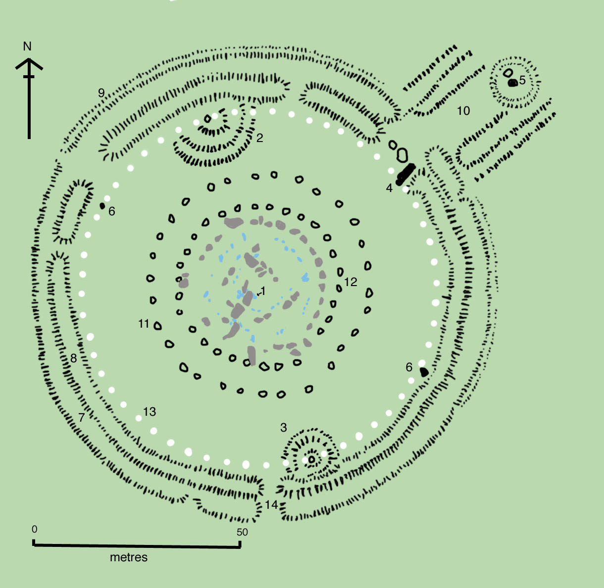
The monument combines a circular bank and ditch (a henge) with massive upright stones and horizontal lintels. Large local sarsen stones form the outer trilithons and lintelled circle, while smaller bluestones—transported from Wales—are arranged within. The stones and earthworks create a complex of interrelated parts, including burial pits, nearby barrows and avenues that link Stonehenge to its wider landscape.
Construction and chronology
Archaeological study shows Stonehenge was built in phases over many centuries. Early activity included cremation burials and the shaping of the earthwork; later phases raised the great uprights and placed lintels. Modern techniques such as radiocarbon dating and geophysical survey have refined the sequence of work and helped explain how prehistoric communities organized labour and transport to raise the megaliths.
Function and meaning
No single explanation covers Stonehenge's purpose. Scholars propose combinations of ceremonial, funerary and astronomical roles: its principal axis aligns with the midsummer sunrise and midwinter sunset, suggesting seasonal observances. The site forms part of a ritual landscape whose use and symbolism changed through time; it remains important in popular ideas about prehistoric religion and society. Many visitors and researchers study the stones as a key prehistoric monument in Britain.
Research, conservation and access
Excavations, surveys and conservation work over the last two centuries have revealed much about Stonehenge while prompting debate about restoration and presentation. The monument is managed for both preservation and public access: a visitor centre and protected approach routes help protect the archaeology. For practical details and guidance, see visitor information and resources on megalithic study and heritage management (megalithic monuments, megaliths).
Notable facts and context
- Material: large sarsen blocks and smaller bluestones set into a circular plan (standing stones).
- Alignment: solar orientations to solstices suggest calendrical or ritual use.
- Landscape: part of a wider complex of barrows, avenues and related sites that indicate long-term ritual importance.
- Cultural role: a focus for research, tourism and modern ceremonial gatherings.
Stonehenge's enduring appeal comes from the combination of visible engineering, ancient ritual significance and the mysteries that remain about how and why prehistoric people created such monumental works. For archaeological context and further reading consult specialist surveys and databases that document the site's place in the henge tradition and prehistoric Britain (Wiltshire, England).

Overview
The name Stonehenge is already documented in Old English as Stanenges or Stanheng. While the first element of the name is the Old English word stān "stone", there is uncertainty about the second element. It could be hencg "hinge, hinge" or a nounic derivation from the verb hen(c)en "to hang," which would then mean "gallows." In fact, medieval gallows possessed two feet and thus resembled the triliths in the center of the monument. The also attempted interpretation as "(in the air) hanging stones", however, lacks semantic consistency.
The second component of the name, henge, is used today as a technical archaeological term for that class of Neolithic structures consisting of a ring-shaped raised enclosure with a ditch running along the inside. Stonehenge itself, according to current terminology, is a so-called atypical henge, since the ditch lies outside the ring wall.
The complex was continuously modified or built in several phases. These activities extend over a period of about 2000 years. However, the site was demonstrably used even before the first stone construction. Three large presumed postholes located outside the ring wall near the present parking area date to the Middle Stone Age, around 8000 B.C. In the vicinity of the cult site, the remains of cremated burials were found in soil samples dating to between 3030 and 2340 B.C.. Accordingly, site was in use as a burial ground even before the stones were erected. The most recent cultic activities (Druids, origin of the Avalon saga?) date back to about the 7th century AD, the artifact to be mentioned here is the grave of a beheaded Anglo-Saxon.
Dating the various phases of the monument's design and understanding their meaning is difficult, since earlier excavation methods did not meet today's standards and there are still hardly any theories that would make it possible to gain a comprehensively informed insight into the thoughts and actions of the people of that time.
Thus, among other things, it remains uncertain what was the function of the holes found in the ground. Some scholars consider that they originally had the task of receiving supporting pillars for the purpose of a no less speculative roofing of the place. Others, on the other hand, hold that such hypothetical trunks were merely phallic symbols or totem poles that were later replaced by towering rocks in the wake of technological advances and cultural-demographic changes (population growth, increase in labor force).
One intuitively understands that the purpose of such constructions is to impress the observer already from a distance, i.e. also to make enemies think twice before they dare to attack. The successive expansion of the constructions could then be interpreted as a symbolic 'arms race' between neighboring tribes. Whether such a dynamic is compatible with the long periods of further development of the monument, however, remains the question. It has also been suggested that the ever-changing structures of Stonehenge reflect memories of the course of military conflicts, for example the displacement of a numerically stronger 'native population'. Such a process could be reflected in the bluestones which were temporarily completely removed (?) from the ring wall. The fact that this inferior culture was subsequently integrated into the territory of the victors - possibly they expressed their superiority especially by the enormous Sarsen horseshoe - would then correspond to the often observed result of a preceding territorial dispute (see also below, in the chapter Urpolitik in the context of the Bluestones and the commentary in section Phase 3 III).
The fact that so far only little material has been discovered from which 14C data could be obtained further complicates the tracing of the temporal development of these cultures, and thus also of the changes to the shape of the monument that were gradually made and only discovered archaeologically in the first place. The sequence of these interventions, which is mostly accepted today, is explained in the further text with reference to the illustrated plan sketch. The megaliths still found today are highlighted by coloring their outlines (blue, brown and black); the capstones of the two Sarsen formations were left out for reasons of clarity, and there is speculation about the disappeared remainder of the thus heavily damaged complex. Partly, the monument was probably used as a quarry for the construction of churches, fortresses and palaces of the powerful during the feudal phase of England, but there are also clear traces of deliberate destruction. Modern archaeology usually interprets carefully dismembered columns, smashed effigies, etc. in the sense of the destruction of a culture by the subsequent victors; in parallel, there seems to have been a change in burial customs from about 1400 cal BC (from megalithic communal graves to graves for individual rulers), which can also be interpreted in this sense.

The plant
The Heelstone and the Sacrificial Stone, and with them the openings of the two central horseshoes, were aligned with the position of the sunrise at midsummer; also, among others, the four stones of the rectangular structure on the ring wall seem to have had to do with various periodicities of celestial mechanics. For these reasons, Stonehenge is often thought to have been a prehistoric observatory, although the exact nature of its use and its significance, such as for sowing and harvesting at the best possible times (see below), are still debated.
Description of the stones (from the inside out)
- The altar stone: a block of five meters of green sandstone closest to the center of the complex.
- Immediately adjacent to it is the small horseshoe: It housed 19 stones made of dolerite, a very hard basalt from the Preseli Mountains in southwest Wales. Because of their bluish shimmer, the megaliths of this material are also called bluestones. Their height reaches up to 2.8 m (towards the open legs it decreases to 70 cm), and their shape is the typical conical one of the Stone Age obelisk. A distinctive feature is that the two stones to the left and right of the base of this horseshoe have a cross-section that corresponds to the geometry of a tongue-and-groove joint used in carpentry.
- The large horseshoe includes the small one. It consisted of ten sandstone blocks (so-called sarsen), each connected in pairs by a third at their top. With a height of over 5 meters, they weighed up to 50 tons and must have been moved on sledges pulled by an estimated 250 men, on inclines by up to 1000 men. Alternatively, the use of draft animals is discussed.
- The mighty Sarsen horseshoe is followed by the circle of originally 60 bluestones. On average, they are a good deal smaller than those of the bluestone horseshoe and are cylindrical in shape (instead of conical).
- The formation of this bluestone circle is surrounded by another circle, again constructed of sarsen: originally 30 in number, about 4.5 m high and connected by 30 laid blocks in such a way that a closed ring structure was formed.
- The sacrificial stone, whose name is also misleading because it is easily confused with the altar stone, is currently located in the middle of the northeastern opening of the ring wall, in a sense in the exit of the complex. The audio guide that leads visitors around the monument states that this stone probably stood upright, and that its red stains are not blood (which would have long since weathered and washed away), but iron oxide inclusions. The naming "sacrificial stone" is therefore more than questionable.
- The Heelstone or Friars Heel, in German called "Fersenstein", stands relatively far outside the Ringwall.
- The four station stones.
Other special features:
- The Aubrey holes (56 pieces)
- The Y and Z holes (29 and 30)
On behalf of English Heritage, laser scans were made of the surfaces of all 83 surviving monumental stones at Stonehenge. A total of 72 previously unknown engravings were discovered. 71 of them show axes (up to 46 cm tall), one a dagger. The site resembles the stone circles in northern Scotland known as the Ring ofBrodgar.


Questions and answers
Q: What is Stonehenge?
A: Stonehenge is a prehistoric World Heritage Site of megaliths located eight miles north of Salisbury in Wiltshire, England.
Q: When was Stonehenge built?
A: Stonehenge was built between 3100 BC and 1550 BC.
Q: How long did it stay in use for?
A: Stonehenge stayed in use until the Bronze Age.
Q: What does the monument consist of?
A: The monument consists of a henge with standing stones arranged in circles.
Q: Is it an important site?
A: Yes, it is probably the most important prehistoric monument in Britain.
Q: Has it attracted visitors over time?
A: Yes, Stonehenge has attracted visitors from very early times.
Q: Where is Stonehenge located?
A:Stonehenge is located eight miles (13 kilometers) north of Salisbury in Wiltshire, England.
Related articles
Author
AlegsaOnline.com Stonehenge — Prehistoric stone circle and ritual landscape in Wiltshire Leandro Alegsa
URL: https://en.alegsaonline.com/art/94055
Sources
- commons.wikimedia.org : Stonehenge
- tools.wmflabs.org : 51°10′43.8″N 1°49′34.3″W / 51.178833°N 1.826194°W / 51.178833; -1.826194