St. Gallen — Swiss city of the abbey, textiles and eastern Switzerland
St. Gallen is an eastern Swiss city and cantonal capital known for its medieval abbey and library, historic textile and embroidery industry, university and role as a regional transport and cultural centre.
Overview
![]() St. Gallen is a city in northeastern Switzerland that serves as the capital of the canton of St. Gallen. It is the principal cultural and economic centre of eastern Switzerland and functions as a regional hub for administration, education and services. The municipality sits at an elevation of about 700 metres above sea level and occupies rolling terrain above the Steinach river, near Lake Constance. With a population of roughly eighty thousand residents, the city combines a compact historic centre with surrounding residential districts, parks and river valleys, and it is often described as the gateway to Appenzell and nearby alpine landscapes.
St. Gallen is a city in northeastern Switzerland that serves as the capital of the canton of St. Gallen. It is the principal cultural and economic centre of eastern Switzerland and functions as a regional hub for administration, education and services. The municipality sits at an elevation of about 700 metres above sea level and occupies rolling terrain above the Steinach river, near Lake Constance. With a population of roughly eighty thousand residents, the city combines a compact historic centre with surrounding residential districts, parks and river valleys, and it is often described as the gateway to Appenzell and nearby alpine landscapes.
Names, language and identity
![]() The modern name commemorates the Irish monk Gallus (Saint Gall), whose 7th‑century hermitage became the focus for the abbey and the later settlement. In Switzerland's national languages the city is known as Saint‑Gall in French, San Gallo in Italian and in Rhaeto‑Romance as Sogn Gagl. Local speech and toponymy reflect these multilingual traditions, while contemporary civic life is conducted primarily in Swiss German and High German with services and information available in other languages.
The modern name commemorates the Irish monk Gallus (Saint Gall), whose 7th‑century hermitage became the focus for the abbey and the later settlement. In Switzerland's national languages the city is known as Saint‑Gall in French, San Gallo in Italian and in Rhaeto‑Romance as Sogn Gagl. Local speech and toponymy reflect these multilingual traditions, while contemporary civic life is conducted primarily in Swiss German and High German with services and information available in other languages.
History
The origins of St. Gallen lie in a monastic foundation established around the early 8th century. A community grew up around the abbey and by the late Middle Ages the settlement had acquired town rights and considerable influence as a centre of learning and manuscript production. The Baroque abbey precinct, which includes the ornate abbey church and the historic collection housed in the Abbey Library, reflects this long ecclesiastical and cultural tradition. The abbey site and the library are recognised as a World Heritage property by UNESCO. Over subsequent centuries the town developed civic institutions and trade connections that shaped its economy and urban fabric; modern municipal and cantonal authorities maintain administrative and cultural responsibilities today (official resources).
Textiles, industry and economy
From the 18th century onwards St. Gallen became internationally associated with the production of fine textiles and machine embroidery. Small workshops and specialised manufacturers produced elaborate embroidered fabrics for fashion and household use, and the city developed technical expertise in textile machinery and design. Although the scale and organisation of textile production have changed, the craft heritage is preserved in museums, archives and contemporary design enterprises. The local economy now combines light industry, services, public administration and higher education, with the internationally oriented University of St. Gallen a major centre for business, economics and law.
Transport and connections
St. Gallen occupies an important position on several regional transport corridors. Rail and road links connect the city with Zurich, Munich and other centres; notable transport axes are described in regional timetables and planning documents, for example the Munich–… corridor and routes such as St. Margrethen–Rorschach–St. Gallen–Winterthur–Zurich. Additional lines link the city with Konstanz and the Lake Constance area (Konstanz–Romanshorn–St. Gallen) and with lakeshore towns and other regional hubs like Rapperswil. These connections make St. Gallen a practical base for exploring eastern Switzerland and nearby parts of Germany and Austria.
Culture, education and visitor highlights
The abbey precinct and its library remain the city's most celebrated attractions, prized for architecture, manuscript collections and Baroque interiors. Textile heritage is interpreted at local museums and through exhibitions that trace the development of machine and hand embroidery. The compact old town, parks, river valleys such as the Sittertobel and a programme of cultural events and fairs add to the city's appeal for residents and visitors. St. Gallen also hosts cantonal institutions and courts that underline its regional importance.
Geography, climate and public life
Situated at the northern edge of the pre‑alpine region, St. Gallen experiences a temperate climate with seasonal variation: cool winters with occasional snow and warm, moderately wet summers. Urban green spaces, walking trails along the rivers and the surrounding rolling hills provide recreational opportunities. Civic life combines long‑standing traditions with contemporary cultural initiatives, and municipal planning emphasises heritage conservation alongside economic development.
Further reading and practical information
- Abbey and library: see the major collections and visiting arrangements at the historic precinct (Abbey Library).
- Transport links and timetables: consult regional rail and road information for corridors such as Munich–… and Konstanz–Konstanz–Romanshorn–St. Gallen.
- Local administration and services: cantonal portals and municipal pages provide current guidance (official canton page).
- Education and research: the University of St. Gallen offers programmes with international links.
- Cultural listings and World Heritage information are available through UNESCO and regional tourism sources (UNESCO).
St. Gallen thus occupies a distinctive place among Swiss cities: a historic monastic centre whose manuscript and textile legacies survive alongside contemporary institutions of learning, administration and culture. The city's layered history, accessible old town and transport connections make it both an object of study for cultural history and a living regional capital.


Geography
In addition to the old city municipality (free imperial city and republic of St. Gallen until 1798) and the former monastery district of the prince abbot, St. Gallen consists of the original villages and hamlets of Bruggen, Hafnersberg, Heiligkreuz, Kräzern, Krontal, Lachen, Neudorf, Notkersegg, Riethüsli, Rotmonten, St. Fiden, St. Georgen, Sittertal, Tablat and Winkeln. These hamlets and villages formerly belonged to the then independent municipalities of Straubenzell and Tablat and were incorporated into the town in 1918 (→ Stadtverschmelzung).
The main part of the town settlement lies in a wide valley between two parallel hills, the Rosenberg with Rotmonten in the north and the Freudenberg in the south. The valley lies on a southwest-northeast axis, yet colloquially spoken of a west-east axis. The valley is bounded in the southwest by the deeply cut Sitterschlucht gorge, and in the northeast the Steinach flows out of the town towards Lake Constance. The historic town centre lies on the upper reaches of the Steinach, where Gallus built his hermitage. Except in the St. Georgen quarter, in the Mühlenenschlucht gorge and in the very north-east of the town, however, there is nothing left of the watercourse because it is channelled to the edge of the town in an underground canal. From the Freudenberg, which offers a local recreation area with the Drei Weieren, a large part of Lake Constance, Thurgau and southern Germany can be seen on a clear day.
Outside the settlement areas, the urban area encompasses a large part of the surrounding hilly landscape. To the west of the Sittertobel, Winkeln lies on the watershed between the catchment area of the Sitter and that of the Glatt. In the centre of Winkeln lies the Bildweier and below Sturzenegg the Gübsensee, which was created as a reservoir for the Kubel power station. North of Winkeln, the town boundary follows the Wisenbach to the Sitter. To the northwest, the border runs under the steep mountain slope with the Sitterwald and Hätterenwald forests for four kilometres in the riverbed of the Sitter to the hamlet of Joosrüti. To the north, the town boundary crosses the range of hills from the Chatzenstrebel to the Peter and Paul Wildlife Park and down into the Galgentobel on the Steinach and from there over the Höchst hill to the Goldachtobel below the hamlet of Paradies. The steep western slope of the Goldach and Martinstobel below the castle site of Rappenstein lies in town territory. At Neudorf, the Martinsbrugg leads across the narrow gorge. In the east, the Bernhardsbach borders the town area from the Vögelinsegg down to the Goldach. In the south, the northern mountain slope below the mountain range, which extends from the Vögelinsegg over the Horst to the Kunzenegg, belongs to St. Gallen with the source streams of the Steinach. In the Weier valley east of St. Georgen lies the man-made Wenigerweiher. From Kunzenegg, the city and cantonal border follows the five-kilometre course of the Wattbach stream to its confluence with the Sitter at Zweibruggen and near the Haggenbrücke bridge.
Because of the special topography of the city, St. Gallen is also called the city of the "thousand staircases", as many staircases lead up the Freudenberg and Rosenberg. The city is also called "The City in the Green Ring", because on the hills in front of the city even today extensive forest areas serve as recreational areas. The highest point of the town is at 1074 m above sea level on the south-eastern border of the town (west of Speicher), the lowest point at 496 m above sea level in the Goldachtobel.
Almost one third of the area of the city of St.Gallen is used for agriculture.
Geology
St. Gallen is located in the area of the shallow midland molasse. Large parts of the city are located on unstable peat soil with a large proportion of groundwater. Many buildings in the city centre (including the railway station and the main post office) were therefore built on piles of oak wood.
The hill ranges southwest of the town belong to the foothills of the Alpstein. The so-called uplifted molasse is characterized by distinct ridges. The hills to the northeast, however, belong to the Lake Constance basin. They form plateaus as flat-lying molasse. Where hard rock is exposed (for example in the Sittertobel), this consists mainly of Nagelfluh, sandstone or marl.
Climate
St. Gallen lies in the temperate climate zone with predominantly changeable westerly wind weather. Since the hills of the city are the first elevations for cloud formations from the west to the northeast, there are often days of accumulated rain or snowfall. The clouds accumulate especially in the Alpstein mountains and precipitation occurs. When the wind is north or northeast, the Gallus city experiences bisenlage, which means it gets very cold. This is usually associated with high fog, as the cold, moist air masses settle on the ground, while higher regions experience fine weather (→ temperature inversion). The large water mass of Lake Constance further supports the formation of fog, especially in autumn and winter (→ Lake Constance climate).
In summer, frequent and prolonged precipitation characterizes the weather, especially strong evening thunderstorms. In case of high fog, which often occurs especially in autumn, the city can be more or less affected. Due to its high altitude, there are days when it is just above the fog layer (at least the higher altitudes), on other days it dissipates during the day, sometimes it remains grey for days. With a southerly foehn, on the other hand, it is sunny and warm. With foehn support, the temperature can rise 10 °C and more in a few hours, although the city is not in the main area of influence of the south wind. In winter, precipitation falls as snow, which can remain in shady locations until April.
The annual mean temperature is 8.3 °C, with the coldest monthly mean temperatures measured in January at -0.3 °C and the warmest in July at 17.2 °C. On average, around 93 frost days and 35 ice days are to be expected here. There are about 19 summer days on an annual average, while there are normally 0.8 heat days. The average amount of precipitation is 1442 mm, most of which falls in summer. The MeteoSwiss weather station is located at an altitude of 776 m above sea level near Notkersegg. Especially during inversions or high fog, it is cooler and/or more humid in the city basin, which is about 100 m lower.
| St. Gallen, 1981-2010 | ||||||||||||||||||||||||||||||||||||||||||||||||
| Climate diagram | ||||||||||||||||||||||||||||||||||||||||||||||||
| ||||||||||||||||||||||||||||||||||||||||||||||||
| Monthly average temperatures and precipitation for St. Gallen, 1981-2010
Source: | |||||||||||||||||||||||||||||||||||||||||||||||||||||||||||||||||||||||||||||||||||||||||||||||||||||||||||||||||||||||||||||||||||||||||||||||||||||||||||||||||||||||||||||||||||||||||||||||||||||||||||||||||||||||||||||||||||||||||||||||||||||||||||||||||||||||||||
City breakdown
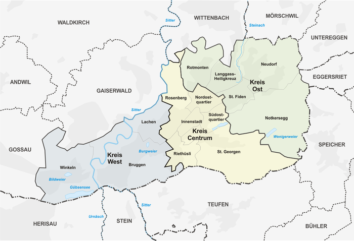
Today, the city is divided into three districts (West, Centrum and East), which in turn are subdivided into neighbourhood groups and quarters. The districts date back to the city amalgamation of 1918. The West district covers most of the area of the former municipality of Straubenzell, the Centrum district that of the former city of St. Gallen and the East district the area of the former municipality of Tablat. Exceptions are St. Georgen, which had belonged for the most part to the municipality of Tablat, and the western parts of Riethüsli, which were part of Straubenzell; these areas were added to the Kreis Centrum. The districts were first divided into 31 statistical quarters in 1966. In 1996, an intermediate level was introduced and the statistical quarters were grouped into 14 groups of quarters. This division is used in the statistics portal of the city of St.Gallen for evaluations of the building and housing statistics (GWS) as well as the population statistics.
The statistical quarters and quarter groups sometimes do not correspond to the perception of the residents, as some areas (such as the Schoren in quarter group Lachen, Dreilinden in quarter group Südostquartier) are assigned to a quarter group that is separated from it topographically or in terms of traffic. This difference is reflected in the boundaries of the 18 quarters represented by the St. Gallen neighbourhood associations, which are presented in a publication by the Office for Social Affairs of the City of St. Gallen and represent the neighbourhood boundaries relevant to residents in their daily lives. The quarters do not have any political rights.
| Circle | Neighborhood Group | BFS code | Population end 2019 | Statistical quarters |
| Circle West The West district extends from Lachen, Schoren and Haggen | Angle | 3203011 | 4'422 | 101 Hafnersberg102 |
| The Bruges | 3203012 | 12'635 | 108 Sittertobel109 | |
| Laughter | 3203013 | 6'851 | 113 Vonwil - Lachen - Schoren | |
| Circle Centrum The centre stretches from Rosenberg into | Rosenberg | 3203021 | 4'054 | 201 Hölzli - Joosrüti202 |
| Riethüsli | 3203022 | 4'139 | 203 Riethüsli | |
| St. Georgen | 3203023 | 5'031 | 204 St. Georgen - Bernegg209 | |
| Downtown | 3203024 | 2'491 | 205 St. Leonhard-East206 | |
| Northeast Quarter | 3203025 | 3'190 | 207 St. Jacob | |
| Southeast Quarter | 3203026 | 4'333 | 208 Linsebühl - Dreilinden | |
| East circle The eastern part of the city begins at St. Fiden | Rotmonten | 3203031 | 2'649 | 301 Rotmonten |
| Langgass Holy Cross | 3203032 | 7'638 | 302 Langgass - Heiligkreuz | |
| St. Fiden | 3203033 | 7'977 | 303 St. Fiden - Krontal | |
| Notkersegg | 3203034 | 1'755 | 304 Notkersegg305 | |
| New Village | 3203035 | 8'454 | 307 Achslen - Wilen308 | |
|
| ||||
The following municipalities border the area of the city of St. Gallen: Gossau to the west, Gaiserwald and Wittenbach to the north, and Mörschwil, Untereggen and Eggersriet to the east. To the south, the city borders the canton of Appenzell Ausserrhoden with the municipalities of Herisau, Stein, Teufen and Speicher.


History
→ Main article: History of the city of St. Gallen
The founding legend of St. Gallus is dated to the year 612 AD. The foundation of the Abbey of St. Gall is proven for the year 719 by Otmar. There is also another legend concerning the reburial of Otmar, who was condemned by the neighbouring bishop. In 1180 St. Gall became an imperial city. In 1291, Abbot Wilhelm von Montfort granted the burghers of the town the rights laid down in a "Handfeste". In 1319, a confederation was founded with the towns of Lindau and Überlingen, which was extended into the Lake Constance region in the course of the following centuries. In 1349 the plague broke out in the town. In 1403, the Appenzellers and the Schwyzers concluded a land law to fight for freedom against the prince abbot. Only King Ruprecht declared the Lake Constance alliance dissolved. On 23 June 1454, the people of St. Gallen swore to join the Confederation, for which they had to pay the abbot a ransom in 1457.
The Reformation, which was accepted by the town, led to a long-standing dispute between the townspeople and the prince abbot in the monastery courtyard, who owned the entire, now Catholic, surrounding area. This dispute was only settled after the foundation of the canton. During the Thirty Years' War there was another plague in 1629 and 1635. It killed 2420 and 1000 people respectively, i.e. more than a fifth of the town's population. In the Peace of Westphalia in 1648, both St. Gallen received formal and final independence from the German Empire. Even in the 19th century there were deep confessional rifts between the city and the suburban communities.
In 1798, Helvetia brought new cantonal divisions to Switzerland. The territories of the prince abbey, the city of St. Gallen and also Appenzell were combined to form the canton of Säntis, and in 1803 the ring canton of St. Gallen was formed. The abbot had fled to Vienna with a large part of the monastic property. The Catholic denomination of the Canton of St. Gallen, which was subsequently formed for 113 parishes, had been founded in 1847 as an organization of all Catholics in the canton and took over ownership of the monastery building and the religious objects of the monastery. To this day, the Catholic denominational section is responsible, for example, for the financing of the clergy in the canton and for the overall supervision of the Catholic secondary school.
The economic boom in the city of St. Gallen began as early as the Reformation period with the rise of the textile industry in eastern Switzerland. Around 1810 and after 1922 there were major crises in the textile industry. In 1816, a famine broke out as a result of a textile crisis, which claimed around two thousand victims. After the 1930s and the world economic crisis, which hit the St. Gallen embroidery industry hard, 13,000 inhabitants emigrated.
In 1852, the city and canton decided to co-finance the railway line from Zurich via Wil to St. Gallen and on to Rorschach, which was completed four years later. In 1897 the electric tramway was inaugurated. In addition to the St. Gallen lace, banks and insurance companies contributed to the further upswing. Today, St. Gallen is the economic and cultural centre of Eastern Switzerland and the Alpine Rhine. A special feature from the history are the three civil rights that still exist today: St. Gallen, Tablat SG and Straubenzell.
In 2015, St. Gallen was awarded the honorary title of "Reformation City of Europe" by the Community of Protestant Churches in Europe.
Related articles
Author
AlegsaOnline.com St. Gallen — Swiss city of the abbey, textiles and eastern Switzerland Leandro Alegsa
URL: https://en.alegsaonline.com/art/93118