Bass Strait
Shallow sea passage separating Tasmania from mainland Australia, notable for its islands, strong seas, maritime history, and ecological and economic roles.
Overview
The Bass Strait is the body of water that separates the island of Tasmania from the southern coast of the Australian mainland. It takes its name from the British naval surgeon and explorer George Bass, who navigated parts of the passage in 1798. The strait lies adjacent to the state of Victoria and is commonly referred to simply as Bass Strait in maps and maritime reports.
Image gallery
8 Images


Geography and physical characteristics
Bass Strait is relatively shallow compared with open ocean waters, generally measured in tens of metres rather than hundreds. Its bathymetry is dominated by an extensive continental shelf broken by banks and channels. The shallow depth and the meeting of different oceanic currents often create steep seas and rapidly changing weather, contributing to hazardous conditions for navigation. Widely varying seabed features influence local currents and wave patterns, which in turn affect shipping routes and fishing grounds.
Islands and navigational aids
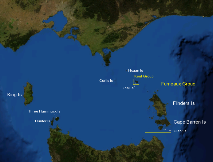
The strait contains numerous islands and island groups, several of which are inhabited or used for grazing and fisheries. Notable islands include King Island and Flinders Island; the Furneaux Group and smaller outcrops also lie within the strait. Because of the navigational risks posed by shallow banks, reefs and strong winds, lighthouse construction was a priority from the 19th century onward. Important navigational lights include:
- Deal Island lighthouse (eastern approaches), constructed in the mid-1800s.
- Cape Otway lighthouse on the mainland coast, established to mark western approaches.
- Cape Wickham lighthouse at the northern tip of King Island, another 19th-century aid to navigation.
History and maritime significance
European exploration of the strait became well documented after Bass and others charted the region in the late 18th century; before that, the waters and islands were known to and used by Indigenous peoples. Throughout the 19th century, Bass Strait was an important but treacherous conduit for shipping between the Australian colonies and international trade routes. Many vessels were lost in storms or ran aground on reefs and shoals, prompting the construction of lighthouses and more systematic charting. The strait remains an active corridor for coastal shipping and fishing traffic.
Ecology, uses, and notable facts
Bass Strait supports a range of marine life and important fisheries, as well as seabird populations that nest on its islands. Its shallow waters and strong mixing can create productive feeding grounds, while also posing challenges for offshore development. The region has been considered for renewable energy projects and is monitored for conservation values and commercial use. Today the strait is valued for its ecological diversity, its role in regional transport, and its place in the maritime history of Australia.
For further reading and maps, see regional guides and historical accounts detailing exploration, lighthouse building and navigation in Bass Strait. Additional information about Tasmania and the adjacent mainland coasts is available through state and national resources: Tasmania, Australian mainland, Victoria, and biographies of early explorers such as George Bass.
Questions and answers
Q: What is Bass Strait?
A: Bass Strait is a sea strait separating Tasmania from the south of the Australian mainland, specifically the state of Victoria.
Q: Who was Bass Strait named after?
A: Bass Strait was named after George Bass who travelled it in 1798.
Q: How wide is Bass Strait at its narrowest point?
A: Bass Strait is about 240 km wide at its narrowest point.
Q: What is the depth of Bass Strait?
A: The depth of Bass Strait is generally around 50 metres deep.
Q: What islands are found in Bass Strait?
A: Many islands are found in Bass Strait, with King Island and Flinders Island home to many towns.
Q: Was Bass Strait a dangerous place for ships to navigate in the past?
A: Yes, Bass Strait was a dangerous place for ships to navigate in the 19th century, with many ships lost.
Q: Were lighthouses built in Bass Strait to help ships navigate safely?
A: Yes, lighthouses were built in Bass Strait, such as the Deal Island lighthouse and the Cape Otway Lighthouse, to help ships navigate safely. Another lighthouse was also built at Cape Wickham at the northern end of King Island.
Related articles
Author
AlegsaOnline.com Bass Strait Leandro Alegsa
URL: https://en.alegsaonline.com/art/9290