
South East England
One of England's nine official regions, encompassing nine counties from Kent and Hampshire to Oxfordshire and the Isle of Wight; notable for its coastline, commuter links to London, and varied economy.
Overview
South East England is one of the nine official regions of England and covers a large and diverse area immediately to the south and south‑east of London. It combines coastal counties, commuter belts, historic towns and productive agricultural land. For official regional information see the regional overview.
Image gallery
10 Images
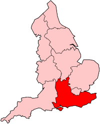


Constituent counties
The region is made up of nine traditional counties and unitary areas. These include Berkshire, Buckinghamshire, East Sussex, Hampshire, the Isle of Wight, Kent, Oxfordshire, Surrey and West Sussex. The Isle of Wight is the region's principal island and has a distinct local identity.
Geography and landscape
The landscape ranges from chalk downland and rolling hills to river valleys and long stretches of coastline on the English Channel and the Thames estuary. The region's highest natural point is Walbury Hill in Berkshire (about 297 m). Much of the area is rural, but large urban concentrations occur along the coast and on corridors leading into London.
Population, towns and economy
In the early 21st century the region had a population of roughly eight million people, making it one of the most populous parts of England outside London. Major urban centres include Brighton and Hove, Portsmouth, Southampton and Reading, alongside many commuter towns that form part of the Greater London urban area. The economy mixes advanced services, manufacturing, maritime industries, tourism and agriculture.
History and development
Administratively the region was established for planning and statistical purposes in the 1990s, though its towns and counties have much older histories stretching back to Roman, Saxon and medieval periods. Historic ports, market towns and university cities such as those in Oxfordshire and Kent have shaped the cultural landscape.
Notable facts and distinctions
- Proximity to London makes parts of the region important commuter and high‑technology corridors.
- The coastline supports ferry links, naval bases and seaside tourism, notably around the Solent and Sussex coast.
- Natural features include chalk downland, areas of outstanding natural beauty and the island ecology of the Isle of Wight.
For more detailed maps, statistics and local government links see the official resources listed above and local county pages linked earlier.
Questions and answers
Q: What is South East England?
A: South East England is one of the nine official regions of England.
Q: When was South East England created?
A: South East England was created in 1994.
Q: Which areas are included in South East England?
A: Berkshire, Buckinghamshire, East Sussex, Hampshire, Isle of Wight, Kent, Oxfordshire, Surrey, and West Sussex are included in South East England.
Q: How populous is South East England?
A: The population of South East England as of the 2001 census was 8,000,550, making it the most populous English region.
Q: What is the highest point in South East England?
A: Walbury Hill in Berkshire is the highest point in South East England at 297m/974 ft.
Q: What are the major urban areas of South East England?
A: The major urban areas of South East England include Brighton and Hove, Portsmouth, Southampton, and Reading.
Q: Are settlements closer to London part of the Greater London Urban Area?
A: Yes, settlements closer to London are part of the Greater London Urban Area.
Related articles
Author
AlegsaOnline.com South East England Leandro Alegsa
URL: https://en.alegsaonline.com/art/92149