Basel — Swiss city on the Rhine
Basel is a Swiss city on the Rhine, capital of canton Basel-Stadt. Known for its medieval centre, major museums and university, a strong pharmaceutical economy, and a tri-border location with Germany and France.
Basel (French: Bâle, sometimes called Basle in English) is a city in the north of Switzerland. Situated at 47°34′N 7°36′E, it has a population of about 170,000 people and is the third-largest Swiss city after Zürich and Geneva. The urban area forms a focal point for culture, commerce and education in the Upper Rhine region.
Image gallery
10 Images


Geography and administration
Basel is the capital of the canton of Basel-Stadt (often abbreviated and administered as Basel-Stadt itself). The city lies on the banks of the Rhine and sits immediately adjacent to the national borders with Germany and France. South of the city is the more rural canton of Basel-Land, which forms part of the broader metropolitan area and commuter belt.
History
Basel's history stretches from a Roman settlement to a prosperous medieval trading town. Its well-preserved Old Town reflects centuries of civic architecture: churches, guild houses and the cathedral are reminders of medieval prosperity. The city became an important center of learning with the foundation of the University of Basel in the 15th century, which remains a major research and teaching institution.
Economy, culture and institutions
Today Basel combines a diversified economy with a strong emphasis on life sciences, chemicals and finance. It hosts major international trade fairs and cultural events, most famously the contemporary art fair Art Basel, which brings galleries and collectors from around the world. Museums such as the Kunstmuseum and the Fondation Beyeler, together with theatres and music ensembles, make the city a cultural hub for the region.
Key landmarks and institutions include:
- Basel Minster and the medieval Old Town
- The University of Basel and research institutes
- Major museums and international fairs (e.g., Art Basel)
- Large pharmaceutical and chemical companies that anchor the local economy
Transport links are strong: Basel is a rail and road hub for north–south and east–west routes, and the tri-national EuroAirport serves the region. Local life is animated by traditions such as the Fasnacht carnival and the annual Rhine swim, while cross-border daily commuting underlines the city's role in the transnational Upper Rhine area.
Notable distinctions: Basel is distinguished by its medieval centre combined with modern industry and international cultural reach; its position on the Rhine at the meeting point of three countries gives it a unique cross-border character in central Europe.


Geography
Location
Located in the extreme northwest of Switzerland, the city lies on both sides of the Rhine. Along with parts of the cantons of Schaffhausen and Zurich, Kleinbasel and the northern part of the canton of Basel-Stadt are among the only areas in Switzerland on the right bank of the High Rhine.
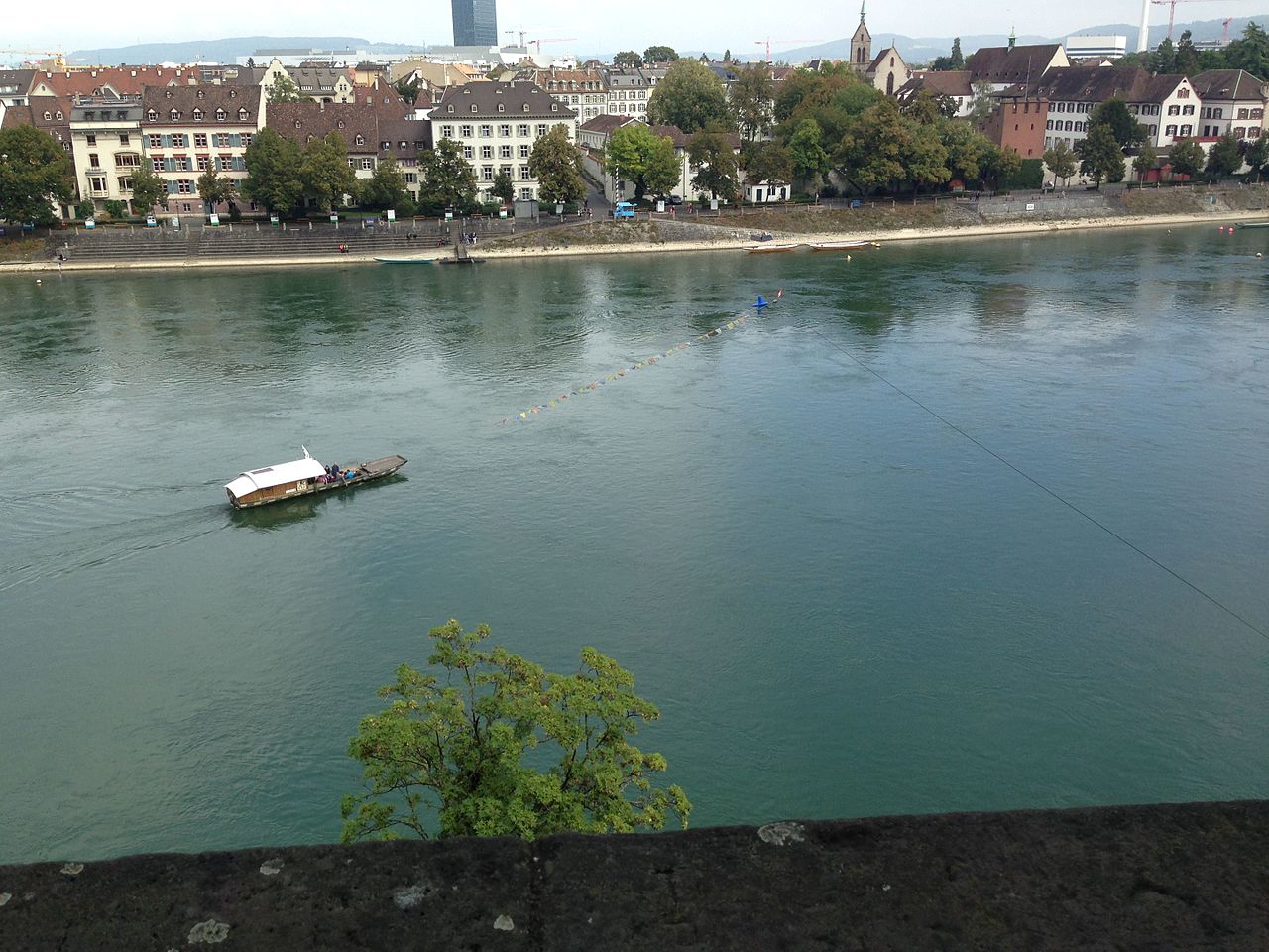
The Rhine changes its direction from east-west to south-north in the urban area of Basel - at the Rhine bend between the Swiss Jura and the foothills of the Black Forest. Here ends the Rhine section High Rhine and begins the Upper Rhine. Shortly before this point, on the higher southern bank of the Rhine, the Birs flows into the Hochrhein, which forms the border with the canton of Basel-Landschaft; the St. Alban-Teich canal, which is diverted from the Birs and comes from the south, also carries water into the Rhine. Immediately below the Mittlere Brücke is the mouth of the Birsig, which is thus the first tributary of the Upper Rhine. On the flatter northern bank, large industrial areas extend from which the Wiese flows into the Upper Rhine.
The Rhine, which shapes the city, is considered an international waterway from its mouth to Basel's old town (historic Mittlere Rheinbrücke). Switzerland was granted these traffic rights in 1868 by the Mannheim Act.
Thanks to its location, Basel became a junction of important transport routes early on and thus an important trading centre. The city is therefore one of the most densely populated areas in Europe, but with a large common land area has 320 ha of green space and 71 ha of forest.
The city of Basel and the two municipalities of Riehen and Bettingen, including their water areas, cover 3694 ha, making it the smallest Swiss canton in terms of area. Nevertheless, there are considerable differences in altitude within this relatively small piece of land. The lowest point in the canton of Basel-Stadt is measured at the Rhine harbour in Kleinhüningen at 245 m, Münsterplatz in the centre is 270 m above sea level, and the highest elevation is above Bettingen at St. Chrischona at 522 m - this is also where the St. Chrischona television tower, the highest free-standing structure in Switzerland, is located.
Neighboring communities
The city of Basel is located at the southern end of the Upper Rhine Plain and the western beginning of the High Rhine Plain at the border triangle of Switzerland-Germany-France, and for this reason has suburbs in all three countries. The inhabitants of Basel are called Basler (or Stadtbasler to differentiate them from the inhabitants of the canton of Basel-Landschaft).
The neighbouring municipalities bordering Basel are (clockwise):
- to the north and north-east Weil am Rhein (Germany) and Riehen (Canton of Basel-Stadt)
- from east to south Birsfelden, Muttenz, Münchenstein, Reinach and Bottmingen (all in the canton of Basel-Landschaft),
- in the west, Binningen and Allschwil (both in the canton of Basel-Landschaft) and the Alsatian municipalities of Saint-Louis and Huningue (France).
· 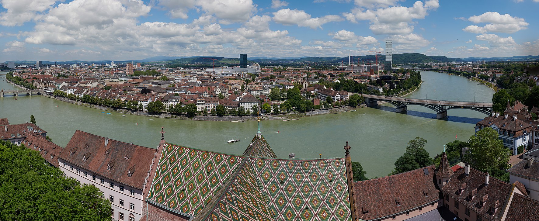
View from the St. Martin's Tower of the Basle Cathedral to Kleinbasel and the Rhine bend. On the left edge the Mittlere Brücke can be seen, on the right the Messeturm, Roche Tower and the Wettsteinbrücke.
Climate
The city of Basel has an extremely mild, sunny climate thanks to its location in the Rhine Valley due to the Mediterranean air flowing in from the Burgundian Gate and also due to its sheltered location as in a little valley and, thanks to the Möhlin jet, there is little fog in autumn compared to the Central Plateau. The annual mean temperature is 10.5 °C, with the coldest monthly mean temperatures measured in January at 1.6 °C and the warmest in July at 19.7 °C. The region has an average of around 64 frost days. On average, around 64 frost days and 13 ice days are to be expected here. There are around 52 summer days on average over the year, while 10.8 heat days are normally recorded. The MeteoSwiss weather station is located at an altitude of 316 m above sea level in the suburb of Binningen, about 2 km from the city centre (as the crow flies).
At 12.26 °C, the annual mean temperature in 2018 was 2.52 K above the 1961-1990 period mean of 9.74 °C. There is comparatively little rainfall with around 842 mm per year (period 1981-2010). Various exotic plant and palm species also thrive excellently for this reason. Summers can be very hot, while winters are usually mild, even compared to the rest of German-speaking Switzerland.
| Basel/Binningen 1981-2010 | ||||||||||||||||||||||||||||||||||||||||||||||||
| Climate diagram | ||||||||||||||||||||||||||||||||||||||||||||||||
| ||||||||||||||||||||||||||||||||||||||||||||||||
| Monthly average temperatures and precipitation for Basel/Binningen 1981-2010
Source: | |||||||||||||||||||||||||||||||||||||||||||||||||||||||||||||||||||||||||||||||||||||||||||||||||||||||||||||||||||||||||||||||||||||||||||||||||||||||||||||||||||||||||||||||||||||||||||||||||||||||||||||||||||||||||||||||||||||||||||||||||||||||||||||||||||||||||||
Geology
Basel lies in a depression created by the Rhine and surrounded by three low to medium mountain ranges, the French Vosges to the west, the German Black Forest to the east, and foothills of the Jura to the south, southwest and east. As mentioned above, this depression has an impact on the climate of the city and region. The Upper Rhine Plain thus begins in Basel.
Potential earthquake area
→ Main article: Basel earthquake zone
The three plates of the Black Forest, the Vosges and the Jura Mountains collide in the Basel depression and their continuous movement causes a potential earthquake hazard. Basel is one of the most exposed earthquake areas in Switzerland. One of the largest earthquakes in Switzerland occurred in Basel in 1356 and claimed several hundred lives.
Geothermal
→ Main article: Deep heat mining Basel
In the early years of the 21st century, the idea was born to use geothermal energy to harness the energy of an injected underground water reservoir at a depth of 5000 meters below the city. However, the operators underestimated the risk of earthquakes. After test drillings in 2007 and 2008, the Deep Heat Mining Basel project had to be stopped due to individual earth tremors and the rock had to be examined more closely. In January 2012, criminal proceedings were brought against the operators of the project, resulting in an acquittal.
Quarters
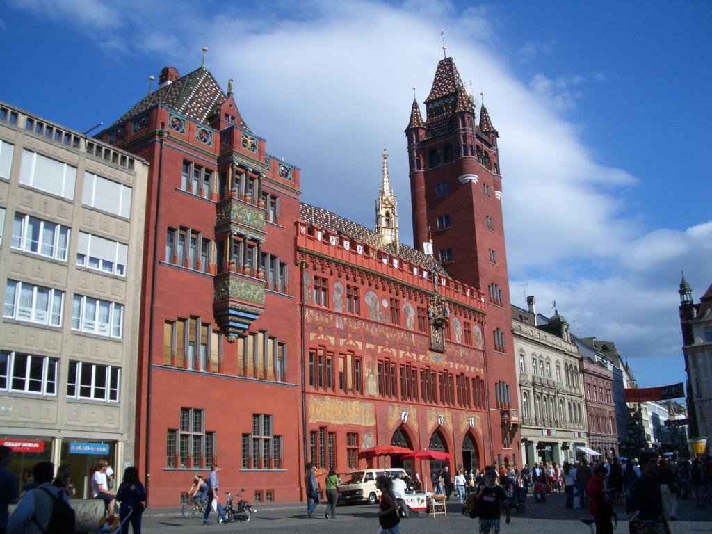
The city is divided into Grossbasel on the left (south-western) side of the Rhine and Kleinbasel on the right bank of the Rhine. The centre of Basel is the old town in the Grossbasel area around the Marktplatz - where the town hall also stands (construction began in 1504) - and the Münsterhügel with the Pfalz-Terrasse rising above the Rhine. The Mittlere Brücke (Middle Bridge) connects the old town on both sides of the Rhine. The tram runs through the city centre, which has been freed from motor traffic.
The city of Basel does not have any political districts or city quarters, but is divided for statistical purposes according to residential areas, the so-called quarters. There are 19 of these quarters, distributed on the left and right of the Rhine.
- Neighbourhoods on the left bank of the Rhine → Grossbasel: Altstadt Grossbasel, suburbs, Am Ring, Breite, St. Alban/Gellert, Gundeldingen, Bruderholz, Bachletten, Gotthelf, Iselin and St. Johann
- Quarters on the right bank of the Rhine → Kleinbasel: Altstadt Kleinbasel, Clara, Wettstein, Hirzbrunnen, Rosental, Matthäus and Klybeck as well as Kleinhüningen (incorporated in 1893)
| Quartier | Hectare | Quartier | Hectare | |
| Old Town Grossbasel | 37,63 | Old Town Kleinbasel | 24,21 | |
| Suburbs | 89,66 | Clara | 23,66 | |
| On the ring | 90,98 | Wettstein | 75,44 | |
| Wide | 68,39 | Hirzbrunnen | 305,32 | |
| St. Alban | 294,46 | Rose Valley | 64,33 | |
| Gundeldingen | 123,19 | Matthew | 59,14 | |
| Bruderholz | 259,61 | Klybeck | 91,19 | |
| Bachletten | 151,39 | Kleinhüningen | 136,11 | |
| Gotthelf | 46,62 | city of Basel | 2275,05 | |
| Iselin | 109,82 | 1086,10 | ||
| St. John | 223,90 | 222,69 | ||
| Canton Basel-City | 3583,84 | |||
Each of the quarters is additionally subdivided into residential districts. Some residential district names are synonymous with the quarter in colloquial language, e.g. residential district Kannenfeld (St. Johann quarter), Lehenmatte (Breite quarter) or Gellert, Dreispitz and St. Jakob (St. Alban quarter). An unofficial, city-wide known name for parts of the Bachletten and Gotthelf quarters is the Neubad.


Name
The origin of the name Basel is not clear. It is assumed that the name is of Roman origin. The former Celtic name of the place is unknown.
The name probably derives from the well-documented Roman personal name Basilius. Place names derived from a suffixless personal name are relatively common in western Switzerland. They are mostly elliptical phrases, where the original Latin common noun has been omitted. Basel is thus likely to be an elliptical formation from an original place name of the type villa Basilis. Who this eponymous Basil was is unknown.
There were also other explanations, for example the derivation from the Greek Basileus, king, (from which the Latin personal name is also derived) or from Basilika; in 1786 Peter Ochs even proposed twelve different interpretations of the name. All these alternative explanations are rejected today.
The oldest known source mentioning the name Basilia comes from the Roman historian Ammianus Marcellinus, who reports that Emperor Valentinian encamped with his troops at Basilia in 374.
A manuscript of the diocese of Basel, the age of which is unknown and which is only dated "before 1461", mentions the name Basel in an account of events that took place in 237/238 ("Basileam applicuerunt"). From this, however, it cannot necessarily be concluded that the name was already in use around 237.
The Celtic names of both the settlement of Basel-Gasfabrik (see below, para. Latène period) and the settlement on the Münsterhügel are unknown. Although Marcellinus mentions a Celtic place name Robur in his report on Valentinian, he evidently refers this name to the fort built by Valentinian on the right bank of the Rhine and not to the settlement.
From the Latin Basilia, the Italian variant Basilea developed later, which is used today in almost all Romance languages; the only exception was the Old French variant Basle, which is still widespread in English-speaking countries and from which the current French spelling Bâle developed. The Germanic variant became established early on and, with few exceptions, is also in use in the other (Eastern) European and non-European languages; only the West Slavic languages and the Greek language use a variation of the Romance name. A special feature is the Icelandic exonym Buslaraborg; it originates from the Leiðarvísir of the monk Níkulás Bergsson, published around 1194, and is still common in Icelandic usage today.
Tags
Related articles
Author
AlegsaOnline.com Basel — Swiss city on the Rhine Leandro Alegsa
URL: https://en.alegsaonline.com/art/9214