Solothurn
![]()
This article is about the city. For other meanings, see Solothurn (disambiguation).
Solothurn (in the local Swiss German dialect Soledurn [ˈsɔlədʊːrn] or [ˈsɔːlədʊːrn], French Soleure, Italian Soletta, Rhaeto-Romanic![]() , Latin Salodurum) is a municipality of inhabitants and the capital of the canton of Solothurn The city with its nearly 17,000 inhabitants (as of 31 December 2019) forms a district in its own right. The cantonal capital of Solothurn is also a centre of a region with around 79,000 inhabitants.
, Latin Salodurum) is a municipality of inhabitants and the capital of the canton of Solothurn The city with its nearly 17,000 inhabitants (as of 31 December 2019) forms a district in its own right. The cantonal capital of Solothurn is also a centre of a region with around 79,000 inhabitants.
Because of the former seat of the French embassy in the Old Confederation (16th-18th centuries), Solothurn is traditionally called the "Ambassadors' City", and also the "Saint Ursus City" because of its patron saint and the name of the cathedral. Most of the old town in its present state was built between 1520 and 1790 and accordingly displays a mixture of different architectural styles and formal idioms, but above all baroque, which is why Solothurn is sometimes called the "most beautiful baroque town in Switzerland".
Geography
Solothurn lies at 430 metres above sea level at the southern foot of the Jura. The city is divided by the Aare into a northern and southern area. Smaller streams include the Brunngraben, the Brühlgraben, the Obach, the Dürrbach and the St. Katharinenbach (from west to east). To the northeast of the municipal area, the Emme flows into the Aare at Emmenspitz.
Topographically, the old town of Solothurn lies on a terminal moraine of the Rhone glacier from the Würm ice age, which is said to have dammed Lake Solothurn after the glacier melted near Wangen an der Aare. Towards the north and on the other side of the Aare towards the south, the municipal area rises to 470 and 450 metres above sea level respectively. The municipal area covers 629 hectares, of which 66% was occupied by settlements, 25% by agriculture and just under 9% by woodland, copses and unproductive land in 1994.
About five kilometres to the north at 1284 metres above sea level is Solothurn's local mountain, Weissenstein, which until 2009 was served by the Oberdorf-Weissenstein chairlift from Oberdorf railway station, replaced by a gondola lift in December 2014.
The nearest major cities in the country are Bern (41 km), Basel (75 km) and Zurich (93 km).
Neighboring communities
Solothurn's neighbouring municipalities are Bellach to the west, Langendorf and Rüttenen to the north, Feldbrunnen-St. Niklaus to the east and Zuchwil and Biberist to the south. Today, the settlement area of Solothurn has grown together almost without any gaps with the built-up areas of Bellach, Langendorf, St. Niklaus and Zuchwil.
Climate
Climatically, Solothurn is under continental European influence, with the parallel constellation of the Aare and the Jura chain resulting in an above-average number of foggy days.
| Solothurn (Wynau) 1981-2010 | ||||||||||||||||||||||||||||||||||||||||||||||||
| Climate diagram | ||||||||||||||||||||||||||||||||||||||||||||||||
| ||||||||||||||||||||||||||||||||||||||||||||||||
| Monthly average temperatures and precipitation for Solothurn (Wynau) 1981-2010
Source : http://www.meteoschweiz.admin.ch/files/kd/climsheet/de/WYN_norm8110.pdf | |||||||||||||||||||||||||||||||||||||||||||||||||||||||||||||||||||||||||||||||||||||||||||||||||||||||||||||||||||||||||||||||||||||||||||||||||||||||||||||||||||||||||||||||||||||||||||||||||||||||||||||||||||||||||||||||||||||||||||||||||||||||||||||||||||||||||||

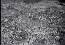
Aerial view (1947)
Population
| Year | Inhabitants |
| 1850 | 5'000 |
| 1900 | 10'100 |
| 1950 | 16'700 |
| 2010 | 16'163 |
With 16,933 inhabitants as of 31 December 2019, Solothurn is the second largest city in the canton of Solothurn after Olten and is one of the smaller cities in Switzerland. In 2009, 75,359 people lived in 24 municipalities in the agglomeration of Solothurn, which includes municipalities from the districts of Lebern and Wasseramt. By 2018, the city of Solothurn wanted to merge with the four surrounding municipalities of Biberist, Derendingen, Luterbach and Zuchwil, which would have increased the city's population to around 42,000. Due to negative referendums, the merger did not come about.
Religions
Solothurn is traditionally Catholic. However, due to internal migration in recent centuries, a large Reformed congregation has also developed in Solothurn. The Christian Catholic congregation is based in the Franciscan Church (Solothurn). Muslims and Buddhists began arriving in the city in the 1970s, 1980s and 1990s.
In 2000, 35.2% of the population was Roman Catholic (5,413 persons), 29.6% was Protestant (4,551) and 5.9% (907) indicated Muslim. A total of 20.2% (3,106) described themselves as non-denominational and 3.9% (599) made no statement.
Immigration
The proportion of foreigners is 21.4 percent, which is above the cantonal average of 20 percent. The largest proportion is made up of citizens from Italy, the former Yugoslavia, Turkey, Sri Lanka, Thailand, Germany and Spain.
Search within the encyclopedia