Singrauli district: history, archaeology, energy and environmental issues
Singrauli district in eastern Madhya Pradesh is an archaeological and coal-rich region known as India’s emerging energy hub, with ancient rock-cut caves, painted shelters and contemporary environmental challenges.
Overview
Singrauli district lies in the eastern part of the Indian subcontinent within the state of Madhya Pradesh and forms a borderland with neighbouring areas of Uttar Pradesh. Administratively it was carved out of the larger Sidhi area and today includes a mixture of forested plateaus, coalfields and industrial towns. The district headquarters is in Waidhan and the wider area is often referred to simply as Singrauli. The region has acquired the informal label of an energy hub because of its extensive coal reserves and the concentration of thermal power generation and mining activity.
Image gallery
5 Images


History and administration
The place once known as Shringavali takes its name from a legendary sage. Historically the territory was sparsely populated and heavily forested; during the period of the princely state of Rewa it was used for confinement of prisoners and exiles. In the 19th century local rule was divided among different chieftains, including Chandela lineages and Rajput rulers who governed separate tracts. On 24 May 2008 the state government reorganised the area to form Singrauli as a distinct district, separated from Sidhi, initially with three tehsils. Two further tehsils, Mada and Sarai, were added on 1 April 2012.
Archaeology and heritage
Beyond its industrial identity, Singrauli contains important archaeological and artistic sites. Rock‑cut caves dating to the early medieval period (commonly assigned to the 7th–8th centuries CE) survive around Mada, about 32 km from Waidhan. Several named caverns such as Vivah Mada, Ganesh Mada, Shankar Mada, Jaljalia and Ravan Mada preserve carved chambers and relief work. In addition, painted rock shelters in parts of Chitrangi tehsil — notably Ranimachi, Dholagiri and Goura Pahad — show pictorial panels executed in red ochre that are associated with Mesolithic microlithic cultures and provide evidence for early human occupation and artistic expression in the region.
Notable sites
- Mada caves: series of rock-cut chambers with sculpted motifs and inscriptions attributed to early medieval artisans.
- Painted shelters: Mesolithic-era red ochre paintings and microlithic remains at Ranimachi, Dholagiri and Goura Pahad.
- Waidhan: administrative centre and gateway to both heritage sites and industrial zones.
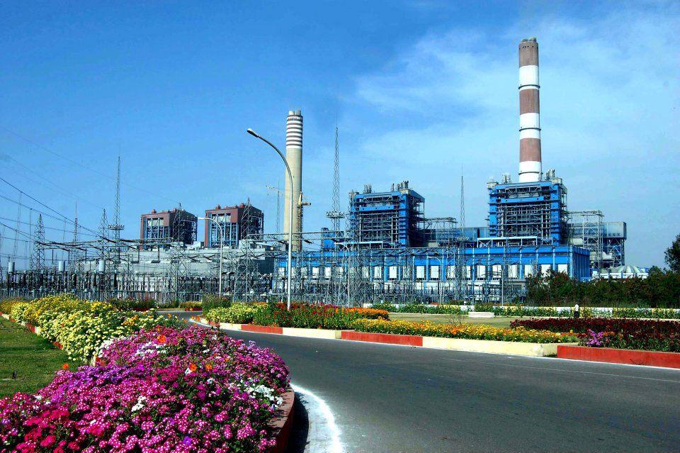
Economy and environment
Singrauli’s economy is dominated by coal mining and coal‑fired power plants; large-scale extraction and energy production have driven rapid industrialisation and migration to the area. At the same time these activities have raised longstanding environmental concerns: air and water pollution, deforestation, alteration of river courses and impacts on local livelihoods. The juxtaposition of ancient rock art and modern industry means that archaeological sites are vulnerable to dust, effluents and changes in land use, and preservation requires concerted monitoring and planning.
Transport, tourism and contemporary challenges
Road and rail links connect Singrauli to neighbouring districts, but many heritage locations remain difficult to reach and lack visitor facilities. Tourism potential centres on the caves and painted shelters, as well as forested landscapes and local cultural traditions, yet poor connectivity and environmental degradation hinder sustainable development. Local and state authorities, researchers and community groups are engaged in balancing energy needs with conservation — a task that includes improving access, documenting vulnerable sites, regulating industrial emissions and promoting awareness of the district’s dual identity as both an archaeological landscape and an important energy-producing region.
For further general context about the broader region see national and state level resources on the history and geography of India and Madhya Pradesh, and administrative records related to Sidhi.
Questions and answers
Q: What is Singrauli?
A: Singrauli is a city in the Indian state of Madhya Pradesh and Commissionaire of Rewa. It is located in the eastern part of the state and the adjoining southern part of Sonebhadra district in Uttar Pradesh.
Q: Who ruled over Singrauli before 1947?
A: The kings of Rewa State ruled over Singrauli (previously known as Sidhi) before 1947.
Q: How many tehsils are there in Singrauli district?
A: There are five tehsils in Singrauli district, namely, Singrauli, Chitrangi, Deosar, Mada and Sarai.
Q: What kind of caves can be found in Mada Tehsil?
A: In Mada Tehsil there are rock cut caves made during the 7-8th century AD. These include Vivah Mada, Ganesh Mada and Shankar Mada, Jaljalia and Ravan Mada.
Q: What other historical sites can be found near Chitrangi Tehsil?
A: Near Chitrangi Tehsil there are painted rock shelters belonging to the Mesolithic age with microlithic implements culture. These paintings were made using red ochre and represent early Indian art history.
Q: Is connectivity by road good around these historical sites?
A: No, connectivity by road around these historical sites is very poor.
Q: Is pollution threatening these historical sites?
A:Yes, pollution is threatening these historical sites.
Related articles
Author
AlegsaOnline.com Singrauli district: history, archaeology, energy and environmental issues Leandro Alegsa
URL: https://en.alegsaonline.com/art/90658