
Barents Sea
A marginal shelf sea of the Arctic Ocean north of Norway and Russia, the Barents Sea is biologically productive, historically important to exploration, and rich in hydrocarbon resources.
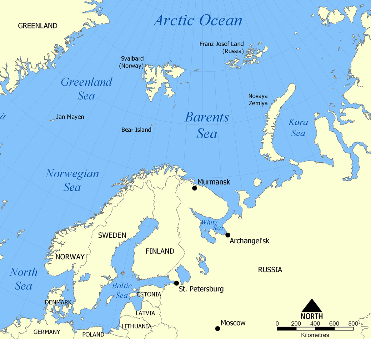
The Barents Sea is a cold, shallow extension of the Arctic Ocean that lies north of Norway and northwest of Russia. It is commonly classified as a marginal sea of the Arctic Ocean. Much of the basin is a continental shelf, with average depths on the order of a few hundred meters and a maximum depth approaching 450 m; its relatively shallow waters and strong exchanges with warmer Atlantic currents give the region a distinct oceanographic character.
Image gallery
10 Images




Geography and oceanography
The Barents Sea is bounded to the west by the Norwegian Sea, to the northwest by the islands of Svalbard, and to the northeast and east by archipelagos such as Franz Josef Land and Novaya Zemlya. The latter separates the Barents Sea from the Kara Sea. Warm, saline water carried northward in the North Atlantic current moderates ice cover along the western and southern margins, while colder Arctic waters influence the northern and eastern reaches. This mixing creates a pronounced polar front and seasonally variable ice conditions.
History and naming
In medieval sources the area was sometimes called the Murman Sea. The modern name commemorates the late 16th-century Dutch navigator Willem Barents, an early explorer of Arctic waters; the naming reflects the era of European exploration and mapping of high-latitude seas. The Dutch connection is often noted in historical accounts of polar voyages and cartography (Dutch seafaring traditions).
Ecology, resources, and uses
The Barents Sea is among the most biologically productive parts of the Arctic because shallow depths and inflowing Atlantic water support plankton blooms that sustain large fish, seabird, and marine mammal populations. Commercial fisheries—most notably for cod and haddock—have long been important. Significant deposits of hydrocarbons and other energy resources exist on the continental margin, and modern exploration and production focus on both onshore and offshore fields; these interests are associated with fossil fuel extraction and related infrastructure.
Contemporary importance and concerns
- Economic: fisheries, shipping routes, and energy development affect regional economies.
- Environmental: oil and gas activity, shipping, and climate-driven reductions in sea ice raise pollution and habitat risks.
- Scientific: the Barents Sea is a key site for studying ocean–ice interactions, climate change impacts, and Arctic ecosystems.
Because it lies at the intersection of Atlantic and Arctic influences, the Barents Sea plays a strategic role ecologically, economically, and geopolitically. Researchers and managers monitor changes in temperature, ice cover, and biological productivity to inform sustainable use and conservation of this sensitive northern sea.
Questions and answers
Q: What is the Barents Sea?
A: The Barents Sea is a marginal sea of the Arctic Ocean, north of Norway and Russia.
Q: What was the Barents Sea called in the Middle Ages?
A: It was called the Murman Sea in the Middle Ages.
Q: Who is Willem Barents?
A: Willem Barents is a Dutch navigator after whom the Barents Sea is named.
Q: What is the average depth of the Barents Sea?
A: The average depth of the Barents Sea is 760 feet (230 m).
Q: What is the maximum depth of the Barents Sea?
A: The maximum depth of the Barents Sea is 1,480 feet (450 m).
Q: What are the borders of the Barents Sea?
A: The Barents Sea is bordered by the Norwegian Sea in the west, the islands of Svalbard (Norway) in the northwest, and the islands of Franz Josef Land and Novaya Zemlya in the northeast and east.
Q: What separates the Kara Sea from the Barents Sea?
A: Novaya Zemlya separates the Kara Sea from the Barents Sea.
Related articles
Author
AlegsaOnline.com Barents Sea Leandro Alegsa
URL: https://en.alegsaonline.com/art/8968
Sources
- books.google.com : The New York Times Almanac 2002