
Shenandoah River
Tributary of the Potomac in Virginia and West Virginia, the Shenandoah River comprises two long forks and a mainstem that drains the Shenandoah Valley and supports recreation, wildlife, and local communities.
Overview
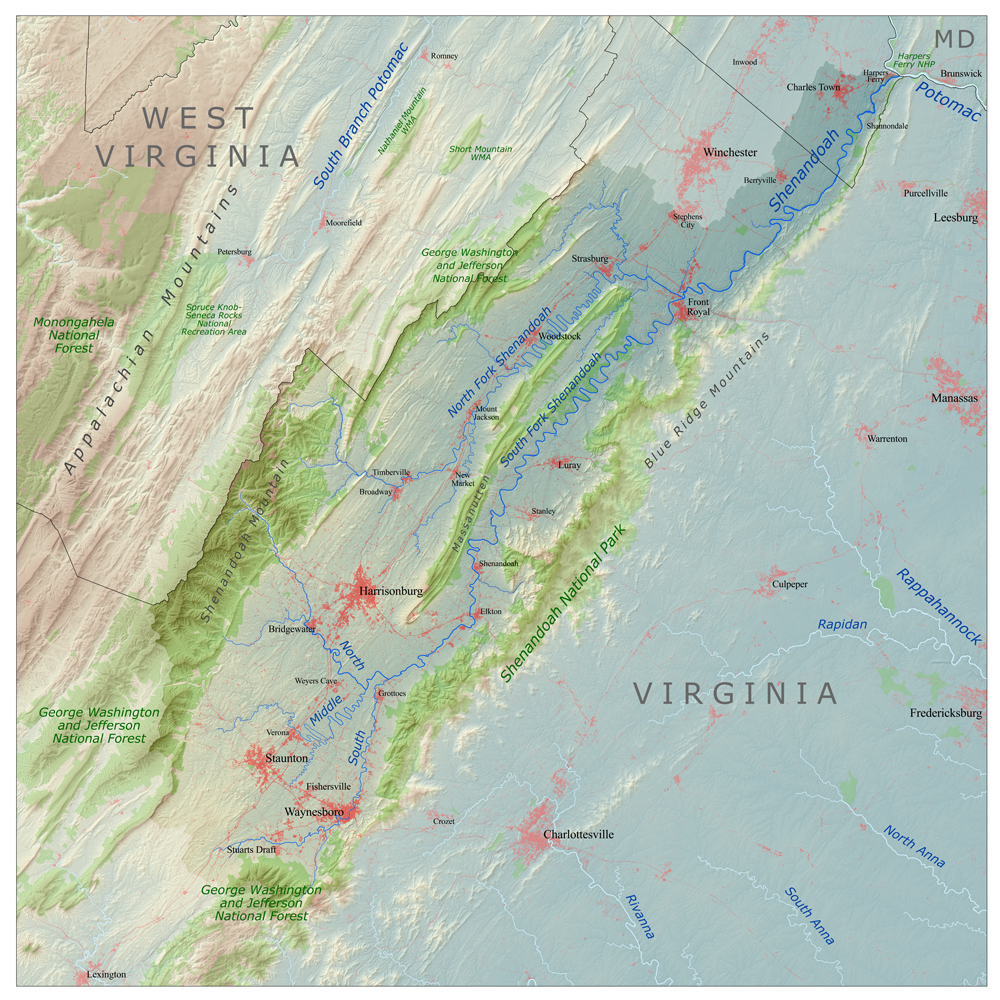
The Shenandoah River is a major tributary of the Potomac River that flows through the Shenandoah Valley in northern Virginia and the Eastern Panhandle of West Virginia. The river system is formed by two principal branches—the North Fork and the South Fork—each of which extends roughly 100 miles before joining to form a mainstem about 55.6 miles long that then flows to the Potomac. The confluence and many mapped points on the river are commonly cited with coordinates such as 39°19′21″N 77°43′40″W.
Image gallery
8 Images



Course and characteristics
The North and South Forks drain distinct portions of the Appalachian foothills and agricultural valleys. After their junction the Shenandoah continues eastward, entering the Potomac River. The river and its tributaries together drain the central and lower Shenandoah Valley as well as the Page Valley in the Appalachians. The Shenandoah is a tributary of the Potomac River and flows across parts of the two U.S. states of Virginia and West Virginia, passing the west side of the Blue Ridge Mountains within the Appalachians and the valley to the west.
History and name
The river has long been important to Indigenous peoples and later European settlers as a source of water, fish, and a corridor for movement. The name "Shenandoah" appears in colonial records and oral traditions; its exact origin is uncertain and is variously attributed to Native American languages or early settler adaptations. Settlements, mills and small river towns developed along its banks through the 18th and 19th centuries.
Uses, ecology and conservation
Today the Shenandoah River supports a wide range of uses: recreational boating, fishing, tubing and wildlife observation are popular, while water from the river contributes to local supplies and agriculture. The river corridor hosts diverse habitats for fish, birds and other wildlife. Like many valley rivers, it is affected by land use changes—agriculture, development and runoff—which have prompted local and regional conservation efforts to improve water quality and preserve riparian habitat.
Notable facts and visitors' information
- The river is commonly enjoyed for canoeing and tubing in summer and trout fishing in cooler reaches.
- The North and South Forks have distinct landscapes and communities upstream of their meeting point.
- For general maps, recreational guides and coordinate references see resources linked here: coordinates, tributary details, and regional pages for the Potomac and the states of Virginia and West Virginia.
Questions and answers
Q: What are the coordinates of the Shenandoah River?
A: The coordinates of the Shenandoah River are 39°19′21″N 77°43′40″W / 39.3225°N 77.727778°W / 39.3225; -77.727778.
Q: How long is the Shenandoah River?
A: The Shenandoah River is 55.6 miles (89.5 km) long with two forks approximately 100 miles (160 km) long each.
Q: Where does the river flow?
A: The river and its tributaries drain the central and lower Shenandoah River valley, as well as Page Valley in the Appalachians on the west side of the Blue Ridge Mountains in northwestern Virginia and Eastern Panhandle of West Virginia.
Q: What states does it run through?
A: The Shenandoah River runs through both Virginia and West Virginia in the United States.
Q: Does it have any tributaries?
A: Yes, it has several tributaries that drain into both sides of the river valley and Page Valley in Appalachians on either side of Blue Ridge Mountains in northwestern Virginia and Eastern Panhandle of West Virginia respectively.
Q: What type of river is it?
A: It is a tributary of Potomac River, meaning that it flows into another larger body of water before emptying out into an ocean or sea elsewhere downstream from its source point at its headwaters or origin point upstream from where it meets other bodies such as lakes or other rivers along its course to its mouth at a delta near an ocean or sea coast line somewhere else downstream from where it begins upstream from its source point at its headwaters or origin point upstream from where it meets other bodies such as lakes or other rivers along its course to its mouth at a delta near an ocean or sea coast line somewhere else downstream from where it begins upstream from its source point at its headwaters or origin point upstream from whereit meets other bodies such as lakes or other rivers alongits course toits mouthat adelta nearan oceanor seacoast linesomewhere elsedownstreamfromwhereit beginsupstreamfromits sourcepointatitsheadwaters ororiginpointupstreamfromwhereitmeetsotherbodies suchaslakesorotherriversalongitscoursetoitsmouthatadeltanearanoceanorseacoastlinesomewhereelsedownstreamfromwhereitbegins
Related articles
Author
AlegsaOnline.com Shenandoah River Leandro Alegsa
URL: https://en.alegsaonline.com/art/89654
Sources
- wdr.water.usgs.gov : "USGS 01636500 Shenandoah at Millville, WV"
- viewer.nationalmap.gov : The National Map
- geonames.usgs.gov : U.S. Geological Survey Geographic Names Information System: Shenandoah River
- simple.wiktionary.org : stalls