
Seward Peninsula
Large peninsula on Alaska’s western coast projecting into the Bering Sea, notable for its geography, Inupiat history, Pleistocene Bering Land Bridge heritage, and Nome gold-rush era towns.
Overview
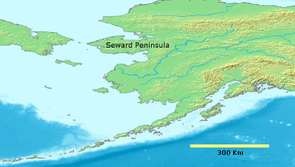
Image gallery
4 Images


Geography and environment
The Seward Peninsula combines coastal lowlands, tundra plateaus, and rugged uplands, including the Kigluaik Mountains and other local ranges. Permafrost, tundra vegetation, and a maritime-influenced subarctic climate shape the landscape: sea ice forms seasonally in the Bering Sea while summers are relatively cool. Marine and terrestrial habitats support migratory birds, seals and walrus alongshore, and land mammals such as caribou and foxes inland.
Human history and archaeology
The peninsula occupies a central place in the story of Beringia. During Pleistocene glacial periods a land connection—often called the Bering Land Bridge—linked what is now Alaska to Siberia, enabling plants, animals, and human populations to move between continents. Archaeological research shows long-term human presence on the peninsula by ancestors of today’s Inupiat peoples; artifacts and sites document millennia of adaptation to coastal and interior environments. The region experienced later contact with Russian and American explorers and traders.
Communities, economy and access
Modern settlements are small and widely scattered. Nome is the largest town on the peninsula and became famous after the turn-of-the-20th-century gold discoveries; the Nome gold rush reshaped local settlement patterns and continues to influence regional identity. Many communities depend on subsistence hunting and fishing supplemented by small-scale mining, government services, and seasonal tourism. Overland transportation is limited—roads rarely connect all villages—so travel often relies on boats, small aircraft, and winter snowmachines.
Conservation and significance
Parts of the Seward Peninsula are protected for their cultural and natural values, including the Bering Land Bridge National Preserve which conserves archaeological sites and diverse ecosystems. The peninsula’s position near the Bering Strait makes it important for studies of climate change, sea-ice dynamics, and migration of species. It also contains Cape Prince of Wales, the westernmost point of the North American mainland.
Notable facts and further resources
- The peninsula played a role in continental migration during the Pleistocene era.
- The region’s indigenous cultures, chiefly Inupiat, maintain strong subsistence traditions and cultural ties to the land.
- For maps and administrative details about the area see regional resources (Seward Peninsula information) and state overviews (Alaska state resources).
Additional reading and local guides can clarify access, wildlife viewing, and community histories: consult regional visitor centers and official land-management pages (Bering Sea region, Arctic Circle context, town of Seward and Kenai Peninsula distinctions).
Questions and answers
Q: Where is the Seward Peninsula located?
A: The Seward Peninsula is located on the western coast of Alaska in the Bering Sea, just below the Arctic Circle.
Q: How long and wide is the Seward Peninsula?
A: The Seward Peninsula is approximately 210 miles (330 km) long and 90 to 140 miles (145 to 225 km) wide.
Q: Is the town of Seward, Alaska on the Seward Peninsula?
A: No, it is not. The town of Seward, Alaska is much further south, on the Kenai Peninsula.
Q: What was once part of the Bering land bridge?
A: The Seward Peninsula was once part of a strip of land called the Bering land bridge that connected Alaska with Siberia with mainland Alaska during a time called the Pleistocene Ice Age.
Q: What came across this land bridge into North America during this time period?
A: People, animals, and plants all came across this land bridge into North America during this time period.
Q: How long have Inupiat Eskimos been living in this area?
A: Archaeologists have found proof that Inupiat Eskimos have been living in this area for thousands of years.
Q: When did the Bering land bridge exist?
A: The Bering land bridge existed millions of years ago during a time called the Pleistocene Ice Age.
Related articles
Author
AlegsaOnline.com Seward Peninsula Leandro Alegsa
URL: https://en.alegsaonline.com/art/89248
Sources
- nps.gov : Cultural Resources in the Bering Land Bridge National Preserve
- dcced.maps.arcgis.com : "Shishmaref, Alaska"
- gi.alaska.edu : Volcanoes, permafrost, earthquakes shape Alaska
- tools.wmflabs.org : 65°20′N 164°15′W / 65.333°N 164.250°W / 65.333; -164.250