Serbia
![]()
The title of this article is ambiguous. For other meanings, see Serbia (disambiguation).
![]()
Srbija is a redirect to this article. For the asteroid see (1564) Srbija.
Template:Infobox State/Maintenance/TRANSCRIPTION
Template:Infobox State/Maintenance/NAME-German
Serbia (Serbian Cyrillic Србија![]() [sř̩bija]; officially Republic of Serbia, Serbian Cyrillic Република Србија [repǔblika sř̩bija]) is a landlocked country in Southeastern and Central Europe. Serbia is located in the center of the Balkan Peninsula, bordered by Hungary to the north, Romania and Bulgaria to the east, northern Macedonia and Albania or Kosovo to the south, Montenegro to the southwest, and Bosnia and Herzegovina and Croatia to the west.
[sř̩bija]; officially Republic of Serbia, Serbian Cyrillic Република Србија [repǔblika sř̩bija]) is a landlocked country in Southeastern and Central Europe. Serbia is located in the center of the Balkan Peninsula, bordered by Hungary to the north, Romania and Bulgaria to the east, northern Macedonia and Albania or Kosovo to the south, Montenegro to the southwest, and Bosnia and Herzegovina and Croatia to the west.
In terms of population, Serbia ranks 22nd among European countries, ahead of Denmark, with a good 7.1 million. The capital and metropolis of the country is Belgrade, other major cities are Novi Sad, Niš, Kragujevac and Subotica. More than 80 per cent of the population are Serbs, but there are also large groups of Hungarians, Roma and Bosniaks.
Serbia's recent history is marked by its role as the largest constituent state of Yugoslavia. Since the final disintegration of Yugoslavia in 2006, it has also been the "sole legal successor" to the Federal Republic of Yugoslavia, which was founded in 1992 (2003-2005 State Union of Serbia and Montenegro).
Serbia is a member of the Black Sea Economic Cooperation (BSEC) and the Central European Free Trade Agreement (CEFTA) and has other free trade agreements. The country's economic performance declined sharply as a result of the Yugoslav wars; it recovered somewhat in the years from 2003 to 2008. After achieving important short-term successes in the EU accession process (including the entry into force of an interim trade facilitation agreement with the EU and the abolition of visa requirements for Serbian citizens), Serbia submitted its candidacy for European Union membership on 22 December 2009 and was granted candidate status on 1 March 2012.
Geography
→ Main article: Geography of Serbia
Note: The description of the geography of Serbia also includes the territory of Kosovo, which is disputed under international law.
Location, relief and geographical division
Serbia stretches across four degrees of latitude on the edge of the subtropics between 46° 11′ N (near Subotica in the northern Serbian province of Vojvodina) and 41° 16′ N near Preševo. From east to west, the Stara Planina near Dimitrovgrad (23° 01′ E). and the Danube near Bezdan (18° 51′ E) form the boundary points. The lowest point is the outlet of the Danube at Prahovo in eastern Serbia, 17 meters above sea level. The highest point is the 2656-meter-high Đeravica in Prokletije (Kosovo) or the 2169-meter-high Midžor on the Bulgarian border.
The territory of Serbia is composed of two types of landscape divided by the Sava-Danube line. North of the Sava and Danube plains lies Vojvodina, a lowland in the Pannonian Plain, where only the gentle rump mountains of Fruška Gora and the Carpathian foothills of the Vršačke Planine stand out somewhat in relief. The former forest steppes of the Danube lowlands are characterized by the hydrological knot of the most important streams of East-Central Europe and by formerly wide floodplain landscapes as well as the aeolian drifting sands (the Deliblatska peščara is known as the "European Sahara") and fertile black earth soils and loess.
South of the Sava and Danube rivers, the country in central Serbia and Kosovo is predominantly mountainous, but presents itself as a topographically diverse and varied area due to the coexistence of mountains, plateaus, basin landscapes and river plains. With the river system of the Morava running practically centrally from south to north, which separates the mountain ranges of the Dinarides, Carpathians and Balkan Mountains into a western and eastern group in the tectonic guideline of the Morava furrow, and the tributaries of the Western and Southern Morava, Ibar and the Drina, the border river to Bosnia, formed as gorges, central Serbia is structured in many ways. In the basins of Metohija and the Blackbird Field and the flanking high mountain ranges such as the highest elevation of Serbia, the Đeravica, the transition to the Pelargonian ("Macedonian") landscape type is found both through the drainage to the Mediterranean (the Blackbird Field drains through the bifurcation of the Nerodimka both to the Black Sea and the Mediterranean) and the interplay of basin landscapes and high mountain horsts.
Waters
Hydrographically, Serbia is mostly located in the catchment area of the Danube, which crosses the country in its middle course over a distance of 588 kilometres. The Danube and its tributaries in the Pannonian lowlands are typical lowland rivers with gentle gradients, numerous oxbows and wide alluvial terraces. Due to the frequent flood risk of Vojvodina, which is located in an important hydrological node, many regulating and hydraulic engineering measures have been created in the form of flood dams, retention basins and also outlet and overflow channels. The most important Danube tributaries here are the Sava (into which the Drina flows), the longest Danube tributary the Tisza, and the Temes. The Danube, Tisza and Sava are also the only navigable waterways in the country.
Among the Danube tributaries of Serbia, the catchment areas of Morava and Drina occupy the largest areas. The longitudinal Morava trench is the main communication artery of the country between the Danube plain and the Mediterranean. Since ancient times, the historically important long-distance road (via militaris) has run through it, which, together with the transversal valleys of the Toplica, Nišava and Zapadna Morava, represents the central natural communication route. Since the Drina Valley, which is also longitudinal, does not represent a continuous communication axis due to its multiple meanders and steep gorge sections, the transversal valleys of the Drina tributaries, on the other hand, could mostly only be integrated into the modern transport infrastructure with the completion of the Belgrade-Bar railway line. Because the Morava Valley geologically also forms a wide tectonic rift whose base consists of crystalline Late Precambrian-Paleozoic rocks, but the Drina Valley runs in Mesozoic sedimentary rocks, which mostly in the form of carbonates allow only steep and narrow canyon valleys, these geological predispositions are also causal for the conspicuous obstacles that the Drina Valley poses for the communicative penetration of the Southeast Dinarides. In eastern Serbia, the Timok catchment is the most important and here its most important transport axis.
The larger mountain rivers of Central Serbia mostly form breakthrough valleys with occasional valley widenings. The middle Drina and Lim valleys are partly stepped by river terraces, on which therefore some larger settlements could be established. Drina and Morava show strongly meandering courses, especially in their lower reaches; these valley sections belong today to the periodically flood-prone landscapes of Serbia, after the Danube and Tisza systems were regulated in the 19th and 20th centuries. Many of the smaller river courses in the mountainous areas, such as the tributaries of the Rasina, are also a constant threat to urban settlements as torrent streams due to episodic flash flood events. Erosion control measures and reforestation efforts in parts of the most vulnerable catchments are particularly intended to minimize the sediment transport volumes that pose the greatest risk during these events.
A significant part of the hydrological systems in Serbia is determined by karst aquifers. These are important in terms of area in the West Serbian-Dinaric limestone mountains and in the Carpatho-Balkan mountain arc of Eastern Serbia (Serbian Carpathians).
Only the extreme southwest of the country is drained by the White Drin to the Adriatic, the extreme southeast via the Pčinja, which flows into the Vardar, to the Aegean.
Today, larger standing waters are mostly found as oxbow lakes on the Danube and Sava; the largest natural lake is Lake Palić with an area of around six square kilometres. Among the artificial reservoirs, Lake Đerdap (Đerdapsko jezero) above the Iron Gate occupies the largest area with 163 square kilometres on the Serbian side (total: 253 km²). Well-known reservoirs are Lake Vlasina on a former high moorland area in the southeast Serbian mountains, Lake Perućac on the Drina and the reservoir in the Uvac canyon.
At 71 meters, Jelovarnik in Kopaonik is the highest waterfall in the country. The largest and longest, but not the deepest gorge in Serbia and in Europe is the Iron Gate.
Climate
Located in the warm temperate climate zone, Serbia is characterized by a temperate continental climate. Precipitation decreases from southwest to northeast, while in particular the precipitation maxima in the southwest shift from early summer to autumn/winter. Thus, a basic feature of the climate of Serbia is established, which is determined by the location to the relatively warm seas (Adriatic, Aegean and Black Sea) and the mountainous nature. The precipitation regime with Mediterranean winter rains disappears with distance from the coast, but can still be observed in the western Serbian mountains and in Kosovo. Only in the more continental Vojvodina the typical precipitation pattern of East-Central Europe with an early summer precipitation maximum, which coincides with the solar maximum, appears.
Due to the chambering of the relief, a variety of microclimatic and macroclimatic modifications occur, which are modified by ventilatory conditions and relief. Mountain climates are found in the higher mountains in the south, west and east of the country.
Winters in Serbia are generally cold and snowy, summers are warm. The coldest month is January, the warmest is July. The lowest temperature recorded so far in Serbia was -38.0 °C (26 January 1954 in Sjenica), the highest was 45.8 °C (16 August 2006 in Paraćin). The average annual temperature in Serbia is 10 °C. The average amount of precipitation is 896 millimeters.
The wind systems are determined by the seasonal pressure gradients. If in winter dry-cold north winds prevail, produced by the Siberian High (Košava, Severac, Moravac); Adriatic lows (in the transitional seasons due to humid-adiabatic foehn effects when the air masses rise from the Adriatic over the Dinarides) bring warm-humid winds from the southwest (Jugozapadni vetar); which are then followed by a short-lived temperature increase in western Serbia and the Sava lowlands. The warm Južni vetar (south wind) is based on the summer etesias, which flows into Serbia from the south across the Morava-Vardar furrow on the front of a Balkan high. While the south wind on the back of the high causes the cooler Meltimi in the Aegean.
Nature reserves and scenic spots
Serbia has five national parks, 20 nature parks and about 590 nature reserves with a total area of 7315.08 square kilometres, which means that more than eight percent of Serbia's area is under nature protection. Serbia has shares in the Green Belt of Europe and is located in the Blue Heart of Europe.
These protected areas, designated for the protection of species and the preservation of the country's biodiversity, also represent supra-regionally important reserves for rare or unique animal and plant species, the unique biotopes as well as landscape elements and landscape forms. Exemplary sites are the steppe dune landscape in the Deliblatska peščara reserve and the primeval mountain forest in the Tara Mountains National Park.
In the Tara Mountains, eleven scattered sites of the pre-glacial relict of the narrow-crowned and "fir-like" (due to its leathery, soft needles) Serbian spruce (Picea omirka (Panč.) Purk.) exist in the National Park. These sites comprise 2760 hectares of special reserve areas, which include Aquilegia nikolicii, a columbine first recognized as a new species in 2013. An unusual relict-endemic deciduous tree, first collected in 1856 by Josif Pančić in the Jastrebica Mountains, is the northern subspecies of the Greek maple (Acer heldreichii ssp. visianii, serb. Planinski javor), which has a distribution centre in Serbia in the subalpine mountain forests. It is the most climate-hardy deciduous tree of the subtropical mountains of the Balkans and, due to the sought-after wood quality, is also traded internationally as an important commercial product in the tonewood segment (even in Italy, violin backs are frequently offered in Balkan maple quality, the English trivial and trade name for Greek maple wood). It is also the most highly quoted raw material for the production of guslen in Serbia, which means that the deposits are subject to strong adjustment.
Among the steppe plants, in the Deliblato Dunes Nature Reserve, in a protected zone covering 34,829 hectares, there are a few locations of the population of the Banat peony (Paeonia officinalis ssp. banatica (Rochel) Soó), consisting of about 40 individual plants, which at the same time constitutes the world population of the forest-steppe plant. Another peony, at the same time the national flower of Serbia - the Byzantine peony - grows in the heat-loving oak forests of eastern Serbia and Kosovo. In folk tradition, it is associated with the blood of the Blackbird heroes and is therefore called the Blackbird Peony (Kosovski božur). Recently, a stand of about 2000 plants of this deep red flowering species, which is also used as a medicinal plant, was discovered on 100 ha at Maljan in Kučaj planina.
The protected landscape areas such as the Suva Planina Special Nature Reserve are home to, for example, Tertiary tropical relics such as the Serbian rock plate or the endemic Pančić columbine. These species, adapted to rocky sites in limestone, are considered typical representatives of the paleoendemic Balkan flora. These protected areas and reserves are also refuges for many other species in the Red Data Book of Serbia.
The five national parks correspond to the category II of the IUCN.
| National Park | accepted in the IUCN list | Opština (Municipalities) | Area (km²) |
| National Park Đerdap | 1974 | Golubac, Majdanpek, Kladovo | 636,8 |
| Kopaonik National Park | 1981 | Raška, Brus | 118 |
| Tara National Park | 1981 | Bajina Bašta | 190 |
| Šara/Sharr National Park | 1986 | Štrpce/Shtërpca, Kačanik/Kaçanik, Prizren, Suva Reka/Suhareka | 390 |
| Fruška Gora | 1960 | Novi Sad, Sremski Karlovci, Beočin, Bačka Palanka, Šid, Sremska Mitrovica, Irig, Inđija | 253,93 |
Eight places in Serbia have been listed in the Ramsar Convention for the Conservation of Wetlands.
| Area | added to the Ramsar Convention | Opština (Municipalities) | Area (km²) |
| Gornje Podunavlje | 2007 | Apatin | 224,8 |
| Labudovo okno | 2006 | Bela Crkva | 37,33 |
| Lake Ludašer | 1977 | Subotica | 5,93 |
| Obedska bara | 1977 | Pećinci | 175,01 |
| Peštersko polje | 2006 | Sjenica | 34,55 |
| Slano Kopovo | 2004 | Novi Bečej | 9,76 |
| Carska bara | 1996 | Zrenjanin | 17,67 |
| Lake Vlasina | 2007 | Surdulica | 32,09 |
Among the scenic sights are numerous geomorphological phenomena. Among them:
- Đavolja varoš (Engl.: "Devil's City") Earth pyramids in southern Serbia (near Leskovac).
- Meander and gorge of the river Uvac (Meandri i klisura reke Uvac) in southwest Serbia (Sandžak).
- Meander and gorge of the Temska River in southeastern Serbia (near Niš).
- Rock of the Babin zub peak in the Stara Planina in southeastern Serbia.
- Rock Stol in eastern Serbia (near Bor).
- Ušaćka pećina (Ušać Cave) in southwestern Serbia.
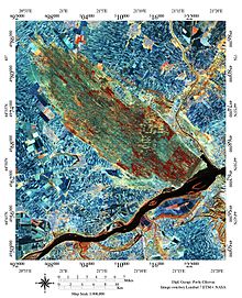
The Deliblatska Peščara. NASA Landsat 7 ETM+
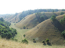
Sand dunes of Deliblatska Peščara
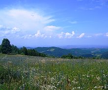
The Šumadija in the centre of Serbia
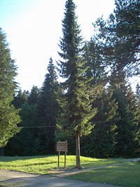
Serbian spruce, Tara National Park
-Jugoslawien_(Serbien).png)
Belgrade climate diagram
.JPG)
Lake Vlasina near Surdulica
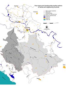
Hydrology with the Morava and Drina river basins
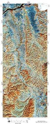
Lower reaches of the strongly meandering Velika Morava to its confluence with the Danube. NASA Landsat 7 ETM+
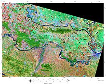
The inter-stream Syrmia of one of the landscapes of Vojvodina. Landsat-8 ETM+ image, 12 March 2014 (infrared false-color aerial image).
Population
With an average age of 40.7 years, the Serbian population is one of the older ones (cf. Germany 46.2) - about 17.4 percent of the population is older than 65 years. The birth rate is 1.78. The average life expectancy is 72.6 years for men and 78.5 years for women. A census in Serbia takes place every ten years, the last census was in 2011.
Ethnicities
The composition of the population varies greatly in the different parts of the country. According to the 2011 census, which did not take place in Kosovo, 83.3% of the inhabitants identified themselves as Serbs. The most significant minorities are Hungarians (3.53%), Roma (2.05%) and Bosniaks (2.02%). Smaller groups include Albanians, Gorans, Bulgarians and Turks in the southern parts of the country, and Croats and Slovaks in the north. In 2017, 9.1% of the population was foreign-born. A large proportion of these are ethnic Serbs originating from other former Yugoslav republics.
According to official statistics, about 148,000 Roma live in Serbia. Unofficially, their number is estimated at 500,000.
In central Serbia live mostly Serbs, but also Wallachians in the east and northeast; Bulgarians in the southeast and northeast; and scattered Roma. In Sandžak, some municipalities are populated by a majority of Bosniaks/Muslims, in the Preševo Valley in the southernmost tip of central Serbia live predominantly Albanians. Overall, 89.48 per cent of the inhabitants of central Serbia describe themselves as Serbs, with Bosniaks representing the second largest ethnic group (2.48 per cent).
Vojvodina (Banat, Batschka and Syrmia) has for centuries been characterised by a mixture of peoples - mainly Serbs (65.05%), Hungarians (14.28%), Slovaks (2.79%), Croats (2.78%), Romanians (1.50%), Roma (1.43%), Bunjewatzen and Schokatzen (about 1%) and formerly also several hundred thousand ethnic Germans (Donauschwaben, Austrians etc.) who were expelled after the Second World War on the grounds of collaboration with the enemy. a.), who were expelled after the Second World War on the grounds of collaboration with the enemy. In recent years, hundreds of thousands of (internal) refugees from the war zones in Croatia, Bosnia and Herzegovina and Kosovo have settled in Vojvodina and the northern part of Serbia. Nevertheless, Vojvodina suffers from a strong population decline. Characteristic is the rural exodus from the actually fertile regions and the growth of the urban population.
The majority of the population in Kosovo today is Albanian (88%). The largest minority are the Serbs (7%).
Languages
The main official language in Serbia is the standard Serbian language. Serbian or Serbo-Croatian is understood and spoken almost everywhere in the country. In the northern Serbian province of Vojvodina, Hungarian, Croatian, Russian, Slovak and Romanian are recognised as official languages in addition to Serbian. Albanian is spoken in Kosovo and parts of southern Serbia.
According to the constitution that came into force in November 2006, the Serbian language in Serbia is officially written in Cyrillic script, although the Latin form is also frequently used in everyday life and in the media.
Religion
The vast majority of the population are Christians, of whom the majority (about 6.3 million) profess the Serbian Orthodox Church. According to the 2011 census, 84.6 per cent of Serbian citizens (excluding Kosovo) profess the Christian Orthodox faith. In addition, there are still with 5 percent Catholics, 1 percent Protestants and a few New Apostolic Christians. Muslims (3.1 per cent) are also resident in Serbia. 3.1 per cent of the population describe themselves as non-denominational, 1.1 per cent as atheists and 0.1 per cent as agnostics.
Previously, the Time Almanac, supported by Encyclopædia Britannica, reported for Serbia, Montenegro, and Kosovo combined 56.8 percent Orthodox, 5.1 percent Catholic, 6 percent other Christian, 16.2 percent Muslim, and 15.9 percent nondenominational and atheist. In contrast, after the independence of Montenegro and Kosovo, the New York Times World Almanac reported 85% Orthodox, 6% Catholic, and 3% Muslim.
Cities and urbanisation
The cities of Serbia developed culturally and historically south of the Sava-Danube line from the Ottoman Çarşı, north of it from Habsburg markets and colonist settlements, which in central Serbia were largely subject to greater modernization even after the Second World War. However, the places in the Serbian part of Sandzak and Kosovo (with the exception of Pristina) partly retained their oriental character.
Urbanisation increased rapidly, especially after 1945, leading to a rapid increase in the population of the larger cities due to industrialisation, rural exodus from poorer regions of the former Yugoslavia and also the migration of war refugees during several waves in the course of the Yugoslav wars.
Among the large cities, the administrative centres of the state, the metropolis of Serbia Belgrade with 1,154,589 inhabitants (10 November 2011) and the seat of government of the autonomous province of Vojvodina, Novi Sad, with 221,854 inhabitants (10 November 2011), play a central role in functional as well as administrative terms. Media and service companies as well as the country's cultural institutions are therefore also concentrated here. Due to their comparatively developed infrastructure, they also have the highest regional importance for transport and trade and show the most dynamic economic development. Due to the central location of Novi Sad and Belgrade on the development axis in Corridor X, they are particularly favoured for investments by the country.
In addition to these primary centres, Niš, with 182,208 inhabitants (10 November 2011), has a complementary central role in southern Serbia after Belgrade. The other larger urban cores of southern Serbia, Leskovac with 59,610 inhabitants (10 November 2011) and Vranje with 54,456 inhabitants (10 November 2011), like Niš, are located on the strategic southern part of the Morava corridor, the historically important main transport axis of the country and likewise of the central Balkan peninsula.
In addition, Kragujevac, with 147,281 inhabitants (10 November 2011), located in the heart of the Šumadija region, and Subotica, with 96,483 inhabitants (10 November 2011), located at Serbia's most important transit crossing to the EU, also have central location functions.
Due to the forced expansion of heavy industry in socialist Yugoslavia, the sites of metal processing and energy production of the ore and lignite deposits mined in the Šumadija region were built up into one of the four important industrial regions in the former Yugoslavia. Therefore, a large part of the remaining Serbian heavy industry is still concentrated here today, which is characterised by a still significant proportion of large military-industrial combines at six locations in particular. This central Serbian industrial belt includes Valjevo with 58,184 inhabitants, Užice with 52,199 inhabitants, Čačak with 72,148 inhabitants, Kraljevo with 63,030 inhabitants and Kruševac with 57,627 inhabitants (as of 10 November 2011).
However, Vojvodina remains the most developed and urbanized region in Serbia. This is why the country's most complex manufacturing and service companies have also settled here. In addition to Subotica and Novi Sad, Zrenjanin with 75,743 inhabitants (10 November 2011), Sombor with 47,485 inhabitants (10 November 2011) and Vršac with 35,701 inhabitants (10 November 2011), as well as the other larger urban centres, are characterised by a comparatively good transport and social infrastructure and also a higher standard of living for the inhabitants than in the rest of the country. In addition, Pančevo, located in Banat, with 73,992 inhabitants (10 November 2011) has increasingly developed into a satellite city of Belgrade since the 1970s and is growing into the metropolitan region of the capital, which continues to develop dynamically in demographic terms.
Based on the 2011 population survey data compared to the previous 2002 census, with the exception of the capital city, only the next two largest centers in the country still have a positive net population.
In Kosovo, Priština assumes the function of the central place and primary economic location.
The major cities of Serbia; number of inhabitants: preliminary results of the 2011 census:
| City | Ew. (narrower urban area) | Ew. (municipality) |
| Belgrade | 1.154.589 | 1.639.121 |
| Novi Sad | 221.854 | 335,701 (with Petrovaradin) |
| Niš | 182.208 | 257.867 |
| Kragujevac | 147.281 | 177.468 |
| Subotica | 105.681 | 141.554 |
| Pančevo | 90.776 | 123.414 |
| Novi Pacar | 85.996 | 125.000 |
| Zrenjanin | 76.511 | 123.362 |
| Čačak | 72.184 | 114.809 |
| Kraljevo | 63.030 | 124.554 |
| Smederevo | 63.028 | 107.528 |
| Leskovac | 60.288 | 144.206 |
Major cities in Kosovo, Kosovo 2011 census:
| City (Serbian Latin/Albanian determined) | Ew. (municipality) |
| Priština/Prishtina | 198.214 |
| Prizren | 178.112 |
| Uroševac/Ferizaj | 108.690 |
| Peć/Peja | 95.723 |
| Đakovica/Gjakova | 94.158 |
| Gnjilane/Gjilan | 90.015 |
| Podujevo/Podujeva | 87.933 |
| Kosovska Mitrovica/Mitrovica | 71.601 |
| Vučitrn/Vushtrria | 69.881 |
| Suva Reka/Suhareka | 59.702 |
The figures are from the latest census, June 2011.
See also: List of the largest cities in Serbia and List of German names of Serbian and Montenegrin places
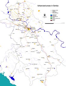
Urbanisation and urban communities
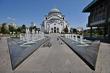
Church of St. Sava of Serbia in Belgrade, one of the largest Orthodox churches in the world
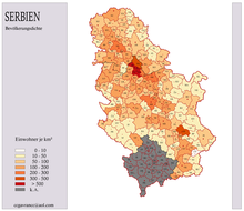
Population density according to the 2002 census
.png)
Ethnic majority areas according to the 2002 census
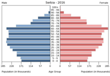
Population pyramid of Serbia without Kosovo 2016
Questions and Answers
Q: What are the coordinates of Serbia?
A: The coordinates of Serbia are 44°N 21°E.
Q: What is the capital city of Serbia?
A: The capital city of Serbia is Belgrade.
Q: What countries border Serbia to the north?
A: Hungary borders Serbia to the north.
Q: What countries border Serbia to the east?
A: Bulgaria and Romania border Serbia to the east.
Q: What country borders Serbia to the south?
A: North Macedonia borders Serbia to the south.
Q: What countries border Serbia to the west?
A: Montenegro, Bosnia and Herzegovina, and Croatia all border Serbia to the west.
Search within the encyclopedia