Seoul
Seoul (Korean ![]() [sʌ.ul/sɔʊl]; see also Seoul's name) is the capital of South Korea. The official Korean name is "Special City of Seoul" (서울특별시 Seoul Teukbyeolsi). This designation refers to its status as the capital and its administrative equality with the provinces (see also Administrative division of South Korea).
[sʌ.ul/sɔʊl]; see also Seoul's name) is the capital of South Korea. The official Korean name is "Special City of Seoul" (서울특별시 Seoul Teukbyeolsi). This designation refers to its status as the capital and its administrative equality with the provinces (see also Administrative division of South Korea).
The population of Seoul is approximately 9.8 million (2019). The city is the center of the Sudogwon metropolitan area (수도권, 首都圈), which is home to about 25.4 million people (2015), or about one-third of the entire Korean Peninsula. Sudogwon is considered one of the five largest metropolitan areas in the world and is the fourth largest economy in the world.
In addition to its status as the capital, Seoul is also the financial, cultural and educational center of South Korea. Fifteen of the Fortune Global 500 companies are headquartered in Seoul, including Samsung, LG and Hyundai. Furthermore, the city hosted the 1988 Summer Olympics and was one of the venues for the 2002 World Cup. As the historical center of South Korea and the origin of the Korean Wave and K-pop, Seoul recorded over 9.5 million tourists in 2018, making it the tenth most visited city in the world.
Seoul was the capital of the Kingdom of Baekje from 18 B.C. to 475, and of the Joseon Empire and the Korean Empire from 1394 to 1910. It was elevated to the capital of the Republic of Korea in 1945. North Korea's constitution also designated Seoul as its legal capital until a 1972 constitutional amendment elevated Pyongyang to the capital of the People's Republic, where the North Korean leadership had established a provisional seat of government since the end of World War II.
Geography
Geographical location
The city is located in the northwestern part of the country near the border with North Korea, an average of 87 meters above sea level on the lower reaches of the Hangang River (한강, 漢江 'Han River'), whose upper reaches Bukhangang 'North Han River' and Namhangang 'South Han River' join east of the city at Yangsu-ri. The city center is surrounded by numerous mountains. Namsan (남산, 南山 'South Mountain') rises in the city center with a television tower and cable car. Mount Bukhansan 'Mountain North of Han[gang]' is in the north of the city, and Namhansanseong Fortress is in the southeast. In the surrounding valleys are many small villages and ancient Buddhist monasteries. South of Seoul is Mount Gwanaksan, an important recreational area.
56 kilometers north of Seoul, on the 38th parallel, which has formed the inter-Korean border since the Korean War, lies the village of Panmunjeom. It was there that the armistice agreement between North and South Korea was signed on July 27, 1953.
In the urban area of Seoul, the hillside flows around several islands, the most important of which is Yeouido. One arm of the river was drained for land reclamation. The historical core of Seoul lies in a geomantically favorable position somewhat north of the river, which flows here slightly w-shaped and after its exit from the urban area in a northwesterly direction towards Ganghwado Island and the Yellow Sea, while to the southwest Seoul merges seamlessly with its port city Incheon.
The geographical coordinates of Seoul are 37° 34′ N, 126° 59′ E37.565654126.978135, which places it approximately at the latitude of Athens (37° 54′ N) and Lisbon (38° 43′ N).
City breakdown
Although Seoul, as a "special city", is considered equivalent to a province in the administrative division of South Korea, its subdivision is the same as that of all other cities - into city districts (구, 區 Gu) and city quarters (동, 洞 Dong). Seoul is divided into 25 boroughs, the first seven of which were established in 1943. The districts are divided into 522 dong, these in turn into 13,787 tong, and these finally into 102,796 ban. The latter, however, are hardly used in everyday life. The districts of Seoul are:
- Dobong-gu (도봉구, 道峰區)
- Dongdaemun-gu (동대문구, 東大門區).
- Dongjak-gu (동작구, 銅雀區).
- Eunpyeong-gu (은평구, 恩平區)
- Gangbuk-gu (강북구, 江北區).
- Gangdong-gu (강동구, 江東區).
- Gangnam-gu (강남구, 江南區).
- Gangseo-gu (강서구, 江西區).
- Geumcheon-gu (금천구, 衿川區).
- Guro-gu (구로구, 九老區).
- Gwanak-gu (관악구, 冠岳區).
- Gwangjin-gu (광진구, 廣津區).
- Jongno-gu (종로구, 鍾路區).
- Jung-gu (중구, 中區)
- Jungnang-gu (중랑구, 中浪區)
- Mapo-gu (마포구, 麻浦區)
- Nowon-gu (노원구, 蘆原區).
- Seocho-gu (서초구, 瑞草區).
- Seodaemun-gu (서대문구, 西大門區).
- Seongbuk-gu (성북구, 城北區).
- Seongdong-gu (성동구, 城東區).
- Songpa-gu (송파구, 松坡區).
- Yangcheon-gu (양천구, 陽川區).
- Yeongdeungpo-gu (영등포구, 永登浦區).
- Yongsan-gu (용산구, 龍山區).
Climate
Seoul is located in the temperate zone, the average annual temperature is 12.5 °C. The climate is characterized by strong contrasts, so the annual maximum temperature is 29.6 °C on average in August, the lowest average temperature is -5.9 °C in January. Seoul's suburbs are generally cooler than downtown Seoul due to the urban heat island effect.
Summers are very warm and humid during the monsoon season (called 장마 Jangma in Korean) from June to September, especially in August. The daily maximum temperatures are often beyond 30 °C. The highest temperature recorded in Seoul is 39.6 °C in August 2018. August is on average the hottest month in Seoul; the temperature averages 25.7 °C. 70% of the annual precipitation, which averages 1450.6 millimeters, falls during the monsoon season, 394.7 millimeters of which falls in the rainiest month of July alone. Seoul has an east side climate.
Winters are strongly influenced by cold winds from Siberia and therefore very cold, but dry. Usually, three very cold days and four warmer days alternate due to a certain high pressure constellation. The coldest month is January, with an average temperature of -2.4 °C, which also has the least precipitation, averaging 20.8 millimeters. The lowest temperature recorded in Seoul was -23.1 °C on December 31, 1972. Even though the coldest temperatures date back to the early days of climate records, temperatures of -10 °C are not uncommon.
| Seoul | ||||||||||||||||||||||||||||||||||||||||||||||||
| Climate diagram | ||||||||||||||||||||||||||||||||||||||||||||||||
| ||||||||||||||||||||||||||||||||||||||||||||||||
| Monthly average temperatures and precipitation for Seoul
Source: KMA, data: 1981-2010 | ||||||||||||||||||||||||||||||||||||||||||||||||||||||||||||||||||||||||||||||||||||||||||||||||||||||||||||||||||||||||||||||||||||||||||||||||||||||||||||||||||||||||||||||||||||||||||||||||||||||||||||||||||||||||||||||||||||||||||||||||||||||||||||
Air quality
In recent years, air pollution and particulate matter have become a growing political issue. According to data from the World Health Organization, the annual average concentration of PM2.5 in Seoul was 24 micrograms per cubic meter in 2014, 2.4 times higher than the recommended maximum value of WHO air quality guidelines. The city government provides real-time air quality data on its website. Yellow Dust, emissions from China, and emissions from Korea and Seoul contribute to Seoul's air pollution.
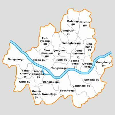
Management structure

Bird's eye view of the city of Seoul
History
Name
→ Main article: Names of Seoul
Seoul was known in the past as Wiryeseong (Hangeul: 위례성; Hanja: 慰禮城, at the time of the Baekje Empire), Hanyang (한양; 漢陽, at the time of Silla), Namgyeong (남경; 南京), and Hanseong (한성; 漢城, at the time of Joseon). During the Japanese occupation, Seoul had the name Keijō (경성; 京城; RR: Gyeongseong).
Unlike other Korean places, there is no spelling in hanja (Chinese characters in Korean) for Seoul. Historically, Korea used Chinese characters, but they were replaced by the Korean script Hangeul. Therefore, almost all Korean places have a corresponding Hanja spelling. Until 2005, the official Chinese name for Seoul was Hànchéng (Chinese 漢城 / 汉城). However, on January 18, 2005, the Seoul government changed the name to the Chinese pronunciation for Seoul to Chinese 首爾 / 首尔, pinyin Shǒu'ěr.
Origin
Archaeological research shows that people settled along the Han River, where Seoul is located today, as early as about 4000 BC. The first historical records of Seoul date back to the first century BC. At the time of the Three Kingdoms, the capital of the Baekje Kingdom, Wiryeseong, was located in the northeastern part of present-day Seoul. Remains of the city wall still exist from this period. In 475, the capital was moved to Gongju and the kingdom of Goguryeo took control of the area. Less than a hundred years later, the Silla Empire gained control of the area. During the Silla period, Seoul was probably just a small village called Hansanju.
Goryeo Dynasty Government
In the later phase of the unified Korean empire of Goryeo, the importance of Seoul grew. In 1068, King Munjong had a summer palace built on the site of present-day Seoul, and the settlement that developed into a city became the administrative seat for the surrounding areas. The city was called Namgyeong ("southern capital"). The actual capital, however, except for very short stretches, was present-day Kaesŏng, located about 60 km to the northwest.
Reign of the Joseon Dynasty
Yi Seong-gye ended Goryeo's rule in 1392, founded the Joseon Dynasty and decided to move the capital. According to a founding story, among pungsu geomancers (experts in feng shui), the power of Gaegyeong, the capital at that time, was considered to be exhausted. Therefore, a new city was to be built at the foot of Gyeryongsan. However, this was not well suited from the point of view of Feng Shui. Instead, the place Hanyang was destined for the capital of a future dynasty. The city was protected by a mountain in the north and a river in the south. Therefore, in 1394, Hanyang was named the capital of Korea and construction began on a new palace, Gyeongbokgung, temples and city walls. The wall was 18 km long and connected the four mountains Bugaksan, Inwangsan, Namsan and Naksan surrounding the city. It still stands there to some extent today. The main city gates have also been preserved. Two of the gates, Sungnyemun (often called Namdaemun) and Dongdaemun, are widely known. The gates were opened and closed daily. A loud bell was rung to signal this.
Further palace buildings followed. From 1405 to 1412 the Changdeokgung was built, and in 1616 the Gyeonghuigung. The name of the city was later changed to Hanseong (한성, 漢城). Although the city's location made it easily defensible and protected by strong walls, it was captured by the Japanese in the Imjin War of 1592 after the Battle of Chungju, and was taken by the Manchurians in 1635. It was not until the reign of King Yeongjo (1724-1776) that the city flourished again, as it was able to take advantage of its good position on the hillside. It grew to become the most important trading center.
In 1872 the king moved back to the Gyeongbokgung. This palace had long fallen into disrepair after being destroyed in the Imjin War and had not been rebuilt until 1865. In the meantime, Changdeokgung, which was not originally intended for this purpose, had served as the seat of government.
Introduction of Christianity in Seoul
In 1784, Yi Pyeok, Kweon Il-shin and Yi Seung-hun established a first church in Seoul with the intention of founding a Catholic religious community. This was exposed to severe persecutions from the beginning. The rulers saw in the Catholics allies of the European colonial powers. The country should remain Confucian. When King Sunjo succeeded his predecessor Jeongjo on the throne, a massive persecution of Catholicism began. In 1801, 1839-1846, and 1866-1876, persecutions of Christians occurred in Seoul and swept the entire country in waves. Nevertheless, the number of Koreans who converted to the Catholic faith grew. The time of persecution and the martyrs are commemorated by the Shrine of the Korean Martyrs on Jeoldusan ("Beheading Mountain") on the banks of the Hangang.
The missionaries used and propagated the now almost forgotten Korean alphabet (한글 Hangeul), which was easier to learn than the Chinese characters (Hanja). During the 19th century, Hangeul was increasingly used in popular education and became accepted as the national script of Korea. This development promoted the spread of the Christian faith, whose scriptures were all published in Hangeul.
With the "opening" of Korea enforced by the USA in 1882, Korea was obliged to tolerate missionary activities. In 1885 the Methodist missionaries Horace Underwood and Henry Appenzellar came to Seoul, who in 1886 together with Presbyterian missionaries founded the still existing Seoul Union Church, in the same year there were also the first secret baptisms of natives. Protestant missionaries had come to Korea before, for example Robert Jermain Thomas, who smuggled Bibles to Korea and was executed in Pyongyang in 1866.
When KoreabecameJapan's colony in 1910, the Japanese demanded the worship of the Tennō. This was rejected by Korean Christians (unlike Japanese Christians) as idolatry. This led to persecution of Christians by the Japanese, but also led to many Christians working in the national independence movement. This and the steadfastness of Christians in persecution led to numerous conversions.
Japanese Colonial Period
Under pressure from Japan, Korea opened up to foreign countries on 24 February 1876. Subsequently, embassies of Japan and Western countries were opened, and a German-Korean friendship and trade agreement was also concluded in June 1882. Foreign companies settled in Seoul and trade continued to flourish. Telegraph lines to Incheon, Ŭiju, and Busan were opened in 1888, and Seoul's first railroad connection opened in 1899 with the Gyeongin line to nearby Incheon. In the same year, the Seoul Electric Tramway began operation. On January 1, 1905, the important Gyeongbu line to Busan was opened, and in November 1905 for general traffic as well. The population, which had been 200,000 for two centuries, began to grow steadily, reaching 730,000 in 1936 and 1,418,000 in 1949.
In 1910, Korea was annexed by Japan and incorporated into the Empire of Japan with the provincial name Chōsen. Hanseong was designated the colonial capital; the official name of the city during this time was Keijō (Jap. 京城; 경성 Gyeongseong, "capital"), capital of the prefecture of the same name (京城府, Keijō-fu; Gyeongseong-bu). The Japanese expanded the city to become the center of the province, greatly enlarged the urban area, and ensured that industry and other economic sectors flourished with large-scale structural measures. The architectural style of the buildings became more modern compared to earlier times. However, a repressive colonial policy was pursued against the population, especially during the Second World War, similar to that in other Japanese-occupied countries: Korean culture was suppressed, men were coerced or forcibly recruited into the Japanese army, and women were abducted to war zones and kept there as so-called comfort women in war brothels, sometimes for years. Korean farmers were forced to give up their land and Koreans were forced to take Japanese names. Japanese was taught in schools.
After Japan's surrender on August 15, 1945, this part of the Japanese colonial empire passed into the American zone of occupation, and Seoul became the seat of the U.S. military government (USAMGIK). Exactly one year after independence from Japan, the city was renamed Seoul. This was the first time that the city was officially named Seoul. With the establishment of the Republic of Korea (South Korea) on August 15, 1948, Seoul became its capital. After being merged with the surrounding province of Gyeonggi-do under Japanese rule, it was now administratively detached from it again and given the status of a special city, equivalent to that of a province.
Korean War
→ Main article: Korean War
On June 25, 1950, the North Koreans crossed the demarcation line and captured Seoul just three days later. The South Koreans were pushed back to a narrow strip around Busan. Only by the landing of UN troops (of it approx. 90 % US troops) with Incheon (28 km west of Seoul) the North Koreans were hit sensitively. The North Koreans entrenched themselves in Seoul and had to be driven out of the city with heavy losses. After three days of fighting, the commander of the US troops declared Seoul liberated on 25 September - three months after the outbreak of the war - even though shots and artillery could still be heard in the northern suburbs.
On January 3, 1951, the South Koreans and Americans had to evacuate the city again, as they could not withstand the superiority of the North Koreans allied with a Chinese "volunteer army". The following day, the city was occupied by North Koreans. By the time Seoul could be retaken on March 14, the North Koreans had kidnapped a large portion of the population. In addition, the city was almost completely destroyed. Eyewitnesses report worse destruction than that of Berlin during World War II.
From the outbreak of the war until August 1, 1953, Busan was the seat of government. However, Seoul was never denied the status of the capital of South Korea.
Recent development
After the end of the Korean War, reconstruction began and Seoul grew very quickly. While the population had dropped significantly during the Korean War, it rose rapidly in the following years. In 1963, the 3 million mark was exceeded. Together with the five-year plans, with which the military government of Park Chung-hee established the economic upswing of South Korea, a plan for the development and modernization of Seoul was also drafted. The administration of the city was placed directly under the Prime Minister. The cityscape underwent massive changes with little regard for the traditional. Besides architectural monuments such as palaces and temples, there are hardly any older buildings than from the 1960s. Due to its proximity to the North Korean border, Seoul could not expand to the north. Population growth was initially concentrated in areas south of the Hangang. Seoul grew to become the political, cultural and economic center of South Korea.
In 1968, the Seoul Tramway ceased operation before the first subway line opened on August 15, 1974. The route network is constantly expanding, also serving the surrounding cities and is connected to Incheon's subway in the west. It is one of the largest subway systems in the world.
In 1986, Seoul hosted the 10th Asian Games before becoming the site of the Summer Olympics two years later. Until 1991 the mayor was appointed by the president, since then he and the city council are directly elected by the population.
In 1994, the city celebrated its 600th birthday, and a time capsule containing 600 items representing the city's modern life was buried on the northern slope of Namsan. The year 1995 brought concern to residents as various structures in the city were destroyed due to construction defects and ineffective official construction supervision. It began with the collapse of the Seongsu Bridge over the Han River in October 1994 (32 deaths), continued through two gas explosions in houses (113 deaths combined), and had a tragic climax in the collapse of the Sampoong Building. This, the worst man-made disaster in South Korea, claimed the lives of 501 people, injured 937 and left six people missing.
During the 2002 World Cup, which was held jointly in South Korea and Japan, the opening match, a preliminary round match and a semi-final match were held in Seoul.
Plans by South Korean President Roh Moo-hyun to relocate the country's seat of government to Chungcheongnam-do Province, 120 kilometers south of Seoul, in the area of the city of Gongju or the neighboring county of Yeongi, have largely failed after massive protests and the negative decision of the Korean Constitutional Court on October 21, 2004. The relocation was a promise made by Roh Moo-hyun during the 2002 presidential campaign to decentralize the administration. Sejong City was established in 2007 and some ministries and agencies were moved there, while many state organs remained in Seoul.
In 2009, in front of the Gyeongbokgung was Gwanghwamun Square. The main gate of the palace is the Gwanghwamun, after which the square is named. Statues of King Sejong and Yi Sun-sin can be found in the square. King Sejong developed the Korean alphabet and renamed the Sajeongmun to Gwanghwamun. The place quickly developed into Seoul's central square. In 2016, millions of people gathered along the square to demonstrate against then-President Park Geun-hye. Directly behind the palace are the Presidential House and Mount Bugak.
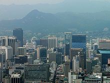
The central district of Jongno
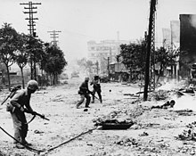
U.S. Marines recapturing Seoul in September 1950.
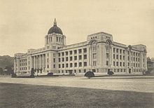
Seat of the Governor General in Keijō.
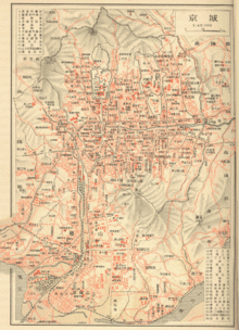
A map of Keijōs from 1937
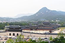
View of the Gyeongbokgung
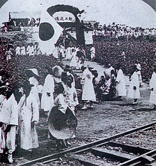
Opening ceremony of the Gyeongbu railway line
Questions and Answers
Q: What is the name of the biggest city in South Korea?
A: The biggest city in South Korea is Seoul.
Q: What is the official name of Seoul?
A: The official name of Seoul is Seoul Special City (Korean: 서울특별시 Seoul Teukbyeolsi).
Q: How many people live in Seoul?
A: Approximately 10 million people live in Seoul.
Q: What percentage of the Korean population does this represent?
A: This represents about 1/5 of the total Korean population.
Q: How much area does it cover?
A: It covers an area of 610 km², which is only 0.6% of South Korea.
Q: Where is it located on the Korean Peninsula?
A: It is located in the middle of the Korean Peninsula.
Q: What major river goes across Central Seoul?
A:The Han River (한강 Han-gang) goes across Central Seoul.
Search within the encyclopedia