Seismology: the study of Earth's vibrations and internal structure
Seismology investigates vibrations of the Earth to reveal subsurface structure, earthquake processes, volcanic systems, and human-made events using seismometers and other sensors.
Seismology is the scientific discipline that records and interprets vibrations that travel through the Earth to infer what lies beneath its surface. It sits within the broader field of geophysics, drawing on principles from physics to understand processes involved in the formation and ongoing dynamics of the Earth and other planetary bodies. By transforming ground motion into digital records, seismologists can reconstruct the timing, size and location of events and map deep structures that are otherwise invisible.
Image gallery
6 Images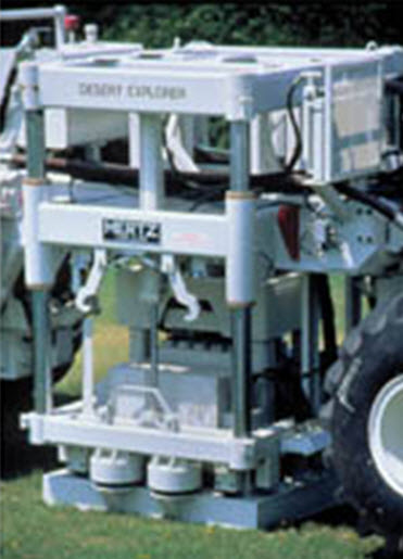


Instruments and how they work
Measurements are made with instruments that convert mechanical motion into electrical signals. Standard sensors include seismometers, which are designed to register a wide range of frequencies, and specialized receivers such as geophones and hydrophones for land and underwater surveys respectively. A typical sensor contains a suspended mass and a sensing element: relative motion between the mass and the instrument body produces a signal through electromagnetic induction or other transduction mechanisms. For example, many sensors rely on a moving coil interacting with a permanent magnet to generate an electrical voltage proportional to ground motion.
Passive and active approaches
Seismology uses two complementary strategies. Passive seismology listens for natural sources such as earthquakes, volcanic tremor, ocean wave interactions and anthropogenic noise. Active seismology creates controlled waves — using mechanical sources, weight drops or small charges — to probe shallower layers with higher resolution. Each approach has trade-offs: passive methods can image large-scale, deep features over time, while active surveys yield detailed pictures of near-surface layering essential for engineering and resource exploration.
Applications and importance
Seismic data support many societal and scientific needs. Key applications include:
- Earthquake monitoring and rapid location of seismic events for hazard assessment and emergency response.
- Volcanic surveillance and investigation of magmatic plumbing systems, informing eruption forecasts and risk mitigation; seismologists often work with volcanologists to study volcano behavior.
- Subsurface exploration for natural resources such as groundwater, oil and gas, and for engineering site characterization.
- Verification of underground explosions and compliance monitoring for nuclear test-ban treaties.
History and notable facts
The practice of detecting ground motions goes back to antiquity: observers in different cultures recorded shaking and designed early instruments to indicate disturbances. An early mechanical seismoscope was developed in China in ancient times to show that distant earthquakes had occurred. Modern quantitative seismology emerged in the late 19th and 20th centuries with improved instruments, global seismic networks and advances in signal processing and computational modeling.
Data analysis and distinctions
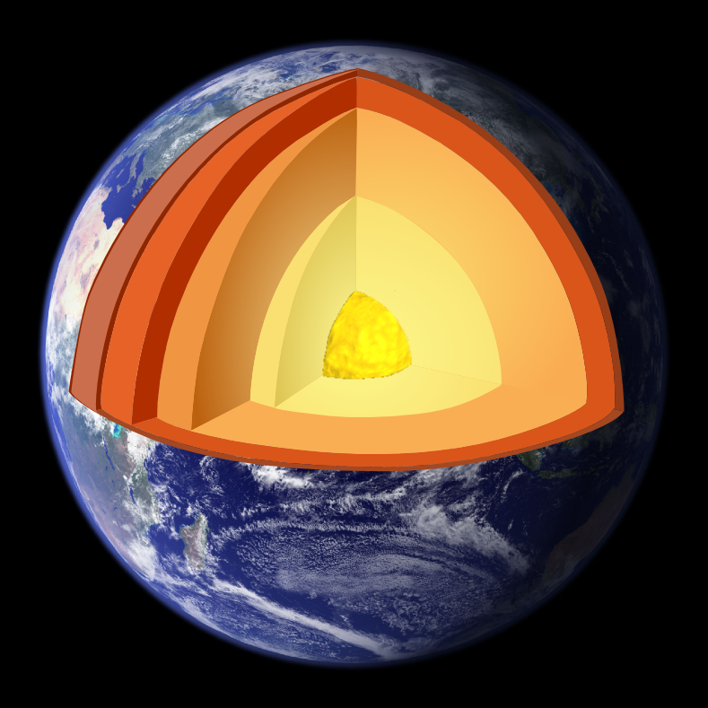
Seismograms are analyzed to estimate source properties (location, depth, magnitude), the path the waves traveled, and local site effects. Different wave types — primary (P) waves, secondary (S) waves and surface waves — carry distinct information: P waves travel fastest through solids and fluids, S waves move only through solids and help identify liquid layers, and surface waves often dominate shaking near the surface. Seismic surveys designed for resource exploration typically emphasize reflected waves, while earthquake seismology focuses on body and surface waves generated by faulting.
Instrumentation and method choice depend on objectives. Field setups may combine many sensor types, including arrays of geophones or networks of broadband seismometers, and in marine settings, arrays of hydrophones. Historical development and instrument design have repeatedly drawn on electromagnetic components such as coils and magnets. For background reading on related disciplines and technologies see resources in geophysics and general references on the physics of planetary interiors (physics, Earth). Early instruments from China are frequently cited in surveys of seismological history (ancient seismometer), and practical insights into volcanic monitoring can be found in literature addressing volcano seismology.
Whether applied to hazard mitigation, scientific research, or resource assessment, seismology remains an essential tool for making the unseen Earth accessible to measurement and interpretation.
Questions and answers
Q: What is seismology?
A: Seismology is the study of what is under the surface of the Earth by measuring vibrations on the Earth's surface.
Q: Who is a person who studies seismology called?
A: A person who studies seismology is called a seismologist.
Q: What is geophysics?
A: Geophysics is a scientific study of the physics of the processes that formed the Earth and other planets.
Q: What devices are used to pick up vibrations in seismology?
A: Seismologists and geophysicists use devices like geophones, hydrophones or seismometers to pick up vibrations.
Q: What are the two types of seismic detectors?
A: The two types of seismic detectors include one that measures up and down vibrations and one that measures side to side vibrations.
Q: What is the purpose of a seismometer?
A: The purpose of a seismometer is to convert vibrations into an electrical signal, which can be stored in a computer for analysis.
Q: What are the possible uses of seismology?
A: The possible uses of seismology include finding the location of earthquakes, picking up underground nuclear tests, examining the crust in a seismic survey to find information about layers of rock, locate oil or gas fields, and understanding the internal structure of volcanoes.
Related articles
Author
AlegsaOnline.com Seismology: the study of Earth's vibrations and internal structure Leandro Alegsa
URL: https://en.alegsaonline.com/art/88610