Seine — major river of northwestern France
The Seine is a principal river of France, rising in Burgundy and flowing northwest through Paris to the English Channel; noted for its historical, commercial and cultural importance.
Overview
The Seine is a major river in France that flows generally northwest from its source in Burgundy to the English Channel. Measured at about 777 kilometres (483 miles), it drains an extensive area and has long been central to the settlement, economy and culture of northern France. Its course links rural headwaters and agricultural lands with large urban centres, most famously Paris, whose historic layout and identity are closely tied to the river.
Image gallery
10 Images


Course, source and basin
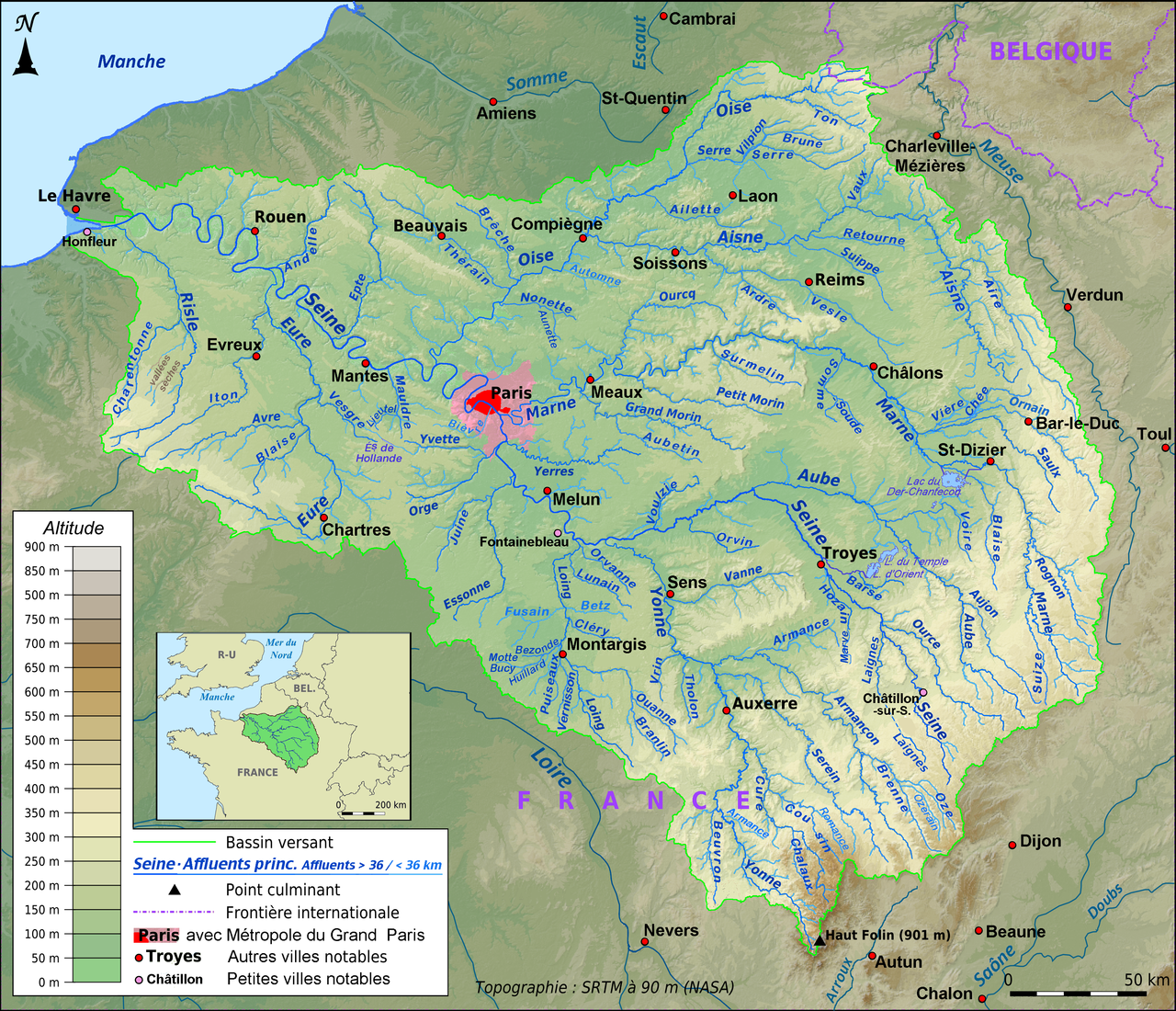
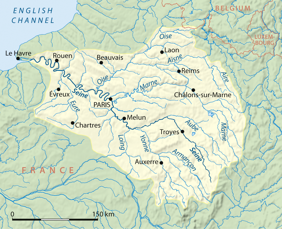
The Seine rises at Source-Seine in the commune of Source-Seine in the department of Côte-d'Or within the region of Bourgogne-Franche-Comté, at an elevation near 444 metres. From there it follows a gently winding route, passing through and near towns such as Troyes and Rouen, before reaching the sea between the ports of Le Havre and Honfleur. The river's drainage basin covers a broad area that supports agriculture, industry and urban populations; this catchment is important for hydrology, flood risk and regional planning.
Tributaries and hydrology
The Seine receives several important tributaries that contribute to its annual flow. Among the largest are rivers well known in the region, which join the Seine along its middle and lower reaches. The lower Seine becomes tidal as it approaches the coast, and tidal influence extends upriver to major ports such as Rouen. Seasonal rainfall, snowmelt in the basin and human alterations such as locks and channels all affect the river's level and flow patterns.
Navigation, ports and economy
The Seine is navigable for a long distance and has historically been one of France's main inland waterways. It supports commercial navigation, local ports, freight traffic and recreational boating. Major ports and harbours along or beside the river and its estuary handle domestic and international trade, while passenger vessels and sightseeing boats are an important part of the tourism economy, particularly in and near Paris.
History, culture and heritage
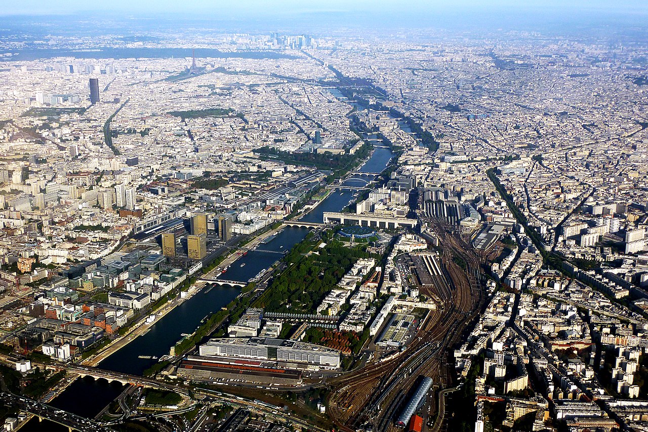
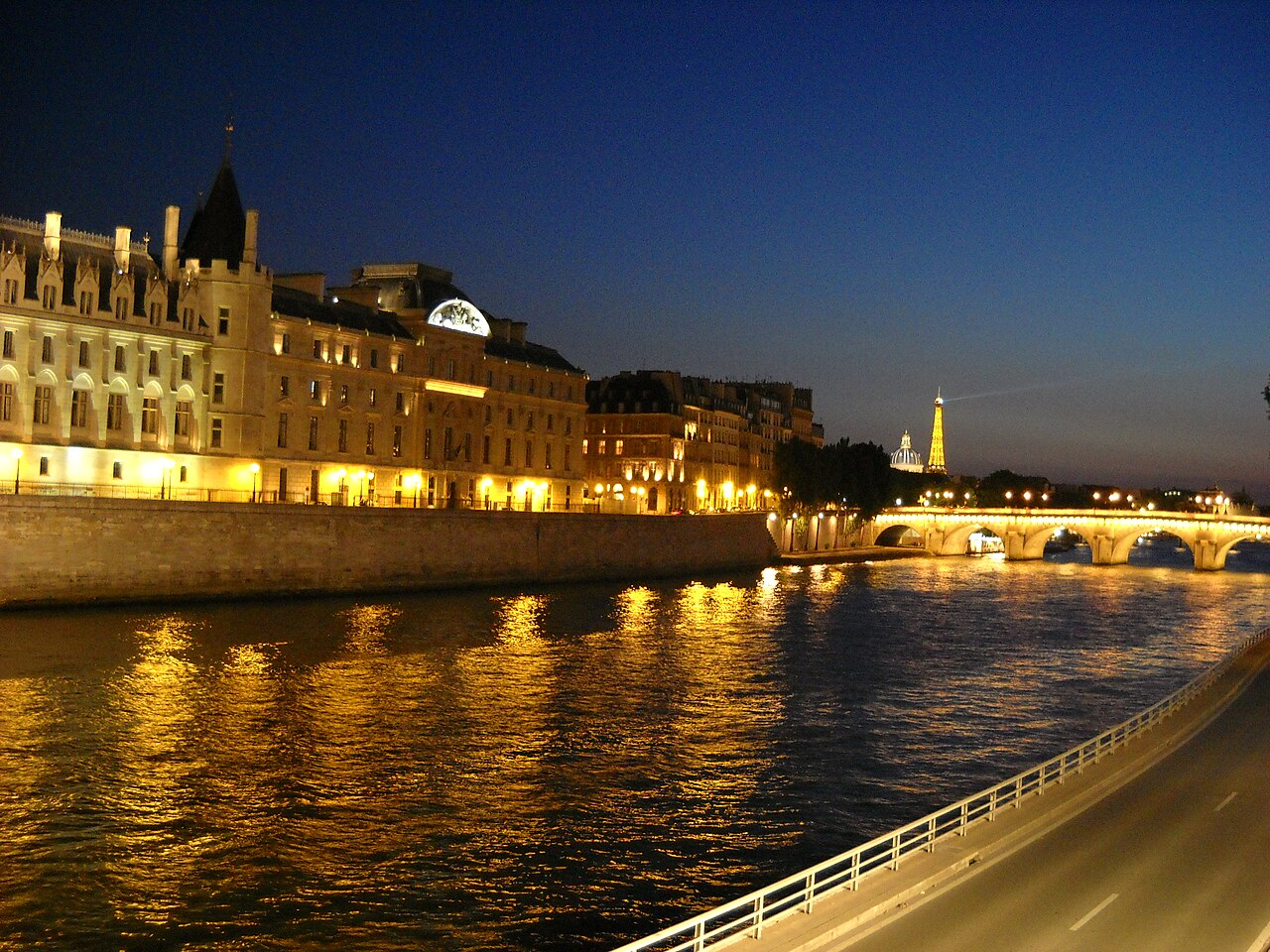
The river has been a transport corridor and focal point for settlement since ancient times. Paris developed on islands and banks of the Seine and many monuments, bridges and quays line its course through the city. The banks of the Seine in Paris, including the Île de la Cité, are recognised for their cultural value. The river has inspired artists, writers and composers, and remains a central motif in French cultural life.
Environment and management
Managing the Seine involves addressing flood risk, water quality, habitat conservation and the needs of urban and industrial water users. Historic floods, including major events that affected Paris, have highlighted the need for monitoring and floodplain management. In recent decades, efforts to reduce pollution and restore aquatic habitats have improved conditions in parts of the river, allowing greater biodiversity and expanded recreational use in selected sections.
Notable places and visitor information
- Paris: the most famous city on the Seine, with many bridges, quays and cultural sites accessible to visitors (Paris).
- Rouen and Troyes: historic towns upstream with riverfronts and inland navigation links (Rouen, Troyes).
- Estuary: the river reaches the sea between Le Havre and Honfleur, where maritime traffic and coastal landscapes meet the river environment.
For research, maps and official information consult regional and national resources covering the basin, public works and environmental agencies in France and the regional authorities of Bourgogne-Franche-Comté and Côte-d'Or. Local guides and port authorities in cities along the Seine provide practical navigation and visitor advice.
Further reading and specialised studies are available through academic and governmental publications; archival records and cultural guides offer detailed histories of the towns and bridges that line the river.
The valley of the Seine
The Seine flows along its entire length through the stratified country of the Paris basin, whose relief is characterized by broad-based high waves, as in the Dry Champagne, and some more concise hills. The narrow valley of the upper course in the plateau of Langres is succeeded in the region of Troyes by a valley bottom about a mile wide between very gentle slopes. Further westwards to the mouth of the Voulzie at Bray-sur-Seine, the valley bottom widens to over 5 km, and finally the slopes become steeper, at least on the north side. The surrounding heights here are about 100 m above the river on the north side, and about 50 m on the south. At Fontainebleau, whose town centre lies in a side valley, there is a valley narrows, in the form of a gate the Seine valley crosses a ridge of heights. At Paris and from there to just before the mouth, the valley runs in numerous loops and correspondingly asymmetrical valley sections with a sliding slope and an impact slope. The width of the valley bottom varies greatly and is narrow for long stretches. The cross-section is asymmetrical even at the Île de la Cité in Paris, where the course of the river is almost straight: south of the river the Quartier Latin does not rise steeply, but nevertheless clearly, while from the north bank the flat Marais ("swamp") extends for several kilometres almost to the Gare du Nord. From Paris to just before the estuary the valley does not become flatter, the valley floor necessarily drops from about 50 m above sea level to near zero, but the elevations remain almost the same.
The Seine valley is known for its numerous castles ("Seine castles"), but also for the automobile industry, petrochemical industry and several power plants located there.

Islands in the Seine
Above the greater Paris area:
- Nogent-sur-Seine: Île Olive, 3 ha
Greater Paris:
- Melun: Île Saint-Étienne, 1200 m × 170 m
- near Évry: Île aux Paveurs, 600 m × 70 m
- Paris:
- Île Saint-Louis, 11 ha, 725 m × 190 m, 2465 inhabitants
- Île de la Cité, 22 ha, 1,19 km × 290 m, 1168 inhabitants
- Île aux Cygnes, 1,3 ha, 890 m × 20 m, uninhabited
- Issy-les-Moulineaux: Île Saint-Germain, 18 ha, parks and residential area
- Boulogne-Billancourt: Île Seguin, 11.5 ha, separated from Île Saint-Germain only by an arm of the river, former Renault factory
- Puteaux: Île de Puteaux, 2,5 km × (140-200) m, recreational area
- Neuilly-sur-Seine and Levallois-Perret: Île de la Grande Jatte, 1,9 km × 150 m, inhabited and recreational area
- L'Île-Saint-Denis: Île Saint-Denis 4,4 km × max. 280 m, 7071 inhabitants
- Carrières-sur-Seine and Chatou: Île de Chatou (Île des Impressionnistes), 8.3 km × max. 280 m
- Louveciennes and Le Port-Marly: Île de la Loge, 2,38 km × (150-220) m
- Andrésy: Île de Nancy, 2.3 km × max. 240 m
Below the Paris metropolitan area
- Near Les Mureaux: Belle-Île, 5.7 km × max. 340 m
- at Mantes-la-Jolie (left bank) and Limay (right bank):
- Île aux Dames: 2,67 km × max. 230 m
- Île l'Aumône: 2 km × max. 278 m
- Bennecourt: Grande Île, 6 km × max 330 m
- Criquebeuf-sur-Seine near Elbeuf: Island with three partial names, Île de Launy - Île de Criquebeuf - Île du Courant, 8.5 km × max. 370 m

Questions and answers
Q: What is the Seine?
A: The Seine is a river in France.
Q: Where does the Seine flow into?
A: The Seine flows into the English Channel between Le Havre and Honfleur.
Q: How long is the Seine?
A: The Seine is 777 kilometres (483 miles) long.
Q: What is the Seine's ranking in France in terms of length?
A: The Seine is the second-longest river in France.
Q: What are some important cities along the Seine's course?
A: Paris, Troyes, and Rouen are some important cities along the Seine's course.
Q: What is the surface area of the Seine's drainage basin?
A: The Seine's drainage basin has a surface of 78,650 kilometres (48,870.84 miles).
Q: Where does the Seine start and at what height above sea level?
A: The Seine starts in Source-Seine, in Côte-d'Or, Bourgogne-Franche-Comté, at a height of 444 metres (1,457 feet).
Related articles
Author
AlegsaOnline.com Seine — major river of northwestern France Leandro Alegsa
URL: https://en.alegsaonline.com/art/88598
Sources
- services.sandre.eaufrance.fr : "Sandre, information on the River Seine"