Seattle, Washington
Seattle is the largest city in Washington state, a Pacific Northwest port and tech hub known for its waterfront, cultural scene, landmark Space Needle, major companies, universities and sports teams.
Overview
Seattle is the largest city in the U.S. state of Washington, located between the waters of Puget Sound to the west and Lake Washington to the east, with the Pacific Ocean beyond the sound. The city proper is home to roughly three quarters of a million residents, while the broader metropolitan area contains several million people. Seattle functions as a regional port, cultural center and a major node in global trade and technology.
Image gallery
10 Images


Landmarks and culture
Visitors often identify Seattle by its skyline and public attractions. The Space Needle, an observation tower, and the city's elevated monorail are visible reminders of the 1962 World's Fair, which helped shape mid-20th-century development. The city has a vibrant arts scene that includes music, theater, visual arts and a well-known coffeehouse culture. Seattle's music history produced globally influential acts and styles; the city's contribution to music includes artists such as Jimi Hendrix and bands like Nirvana and Pearl Jam, which brought international attention in the 1960s and 1990s.
Economy and institutions
Seattle's economy mixes traditional industry and modern technology. Aerospace companies such as Boeing have long had a major presence, while coffee brands like Starbucks and the broader coffee trade are part of the local identity. Upscale retail and department stores such as Nordstrom began in the region, and the city hosts large technology, retail and service employers. Higher education is anchored by institutions including the University of Washington and Seattle University, which contribute to research, workforce development and cultural life.
Sports, recreation and public life
Seattleans follow a number of professional teams and enjoy outdoor recreation on land and water. Notable teams include the Seattle Mariners (baseball), the Seattle Seahawks (American football), Sounders FC in soccer and the WNBA’s Seattle Storm. Parks, waterfront promenades, ferry routes and nearby mountains make boating, hiking and skiing accessible. The city's combination of maritime setting and urban amenities shapes daily life and leisure opportunities.
History and media presence
From its origins as a timber and shipping center, Seattle expanded with rail connections and industrial growth in the 19th and 20th centuries. Its cultural footprint extends into television and film: several series and productions have been set or filmed in the city, including shows like Frasier and Grey's Anatomy, reflecting both the recognizable cityscape and its metropolitan character.
Climate and notable facts
Seattle's climate is often described as a warm-summer Mediterranean type (Csb in the Köppen climate classification), with mild, wet winters and relatively warm, dry summers. The reputation for frequent cloud cover and drizzle is balanced by long summer daylight and extensive green spaces. Today Seattle remains an important Pacific Northwest center for commerce, culture and education, notable for its waterfront geography, entrepreneurial ecosystem and distinctive urban character.
Geography
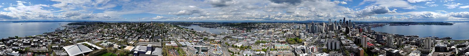
enlarge and show information about the picture
![]()
360° panorama of Seattle, photographed from the Space Needle
Geographical position
Seattle is located on the isthmus between Puget Sound and Lake Washington at 47°37'35" N. B. and 122°19'59" w. L., in the shadow of the Olympic Mountains to the west; the Issaquah Alps and the Cascade range join it to the east. The rivers, lakes, and forests were once very fertile, so that the original inhabitants formed one of the few settled hunter-gatherer cultures.
The city itself is very hilly, with the steepest grades being in Old Town. The geography of the Downtown district has been greatly altered over the decades. Whereas at the beginning of settlement it was a short, flat, and washed-over coastline followed by a bluff, the bluff was flattened and, in order to end the regular flooding, the land on the coast was filled in, so that today one finds a continuous steep rise from the coast in the Downtown district. This work created a network of underground passageways and basements, Seattle Underground.
Seattle is dominated by water, along with mountains and hills. On the western side, Puget Sound allows access to the Pacific Ocean. Within the city are several lakes, such as Lake Washington and Lake Union, which are connected by canals. The city has an area of 369.2 km2. 217.2 km2 of it is land, 152.0 km2 is water. Thus, the share of water in the area is 41.16%.
Due to its location, the city and its surroundings allow a wide range of leisure activities from water sports to hiking and mountaineering to winter sports.
Seattle is located in the Pacific Northwest on a geologically active zone. Several strong earthquakes have shaken the city in its history so far:
- 14 December 1872 (Mw 7.3)
- 13 April 1949 (Mw 7,1)
- 29 April 1965 (Mw 6.5)
- 28 February 2001 (Mw 6,8)
Just 83 kilometres to the southeast is Mount Rainier, a 4,392-metre-high stratovolcano that last erupted in 1854.
Climate
| Seattle, Washington | ||||||||||||||||||||||||||||||||||||||||||||||||
| Climate diagram | ||||||||||||||||||||||||||||||||||||||||||||||||
| ||||||||||||||||||||||||||||||||||||||||||||||||
| Monthly average temperatures and precipitation for Seattle, Washington
Source: National Weather Service, US Dept of Commerce | ||||||||||||||||||||||||||||||||||||||||||||||||||||||||||||||||||||||||||||||||||||||||||||||||||||||||||||||||||||||||||||||||||||||||||||||||||||||||||||||||||||||||||||||||||||||||||||||||
The climate is maritime. There are (September to early June) both humid (humides) and dry (arides) climate (late June to late August). The average annual temperature is 11.2 °C. The frequent rainfall results in an annual total of 857 mm. In summer there is almost no rainfall, while in winter there is up to 140 mm of precipitation per month. Temperatures are mild, which is a typical sign of maritime climate. The lowest average temperatures are around 7 °C, while in summer they reach just under the 20 °C mark between June and September. The surrounding mountains protect the city from strong gusts of wind. In winter there is only light snowfall.

History
The arrival of the Denny family, known as the Denny Party, who landed at Alki Point on November 13, 1851, is considered the birth of Seattle. They relocated to the more sheltered Elliott Bay, now Pioneer Square, in April 1852. The first plans for the establishment of a settlement (Town), known as plats, were filed on May 23, 1853. The corresponding first cadastral boundaries can still be seen in the cityscape today. The town's first boom was based on the lumber industry and the money extracted from the pockets of loggers by enterprising ladies like Mother Damnable, among others. The Seattle municipality has gone through several boom-crash cycles and successfully used times of crisis to expand its infrastructure.
The founding of the city (City) as such dates to 1869, and the naming after the Native American chief Seattle was largely the result of the efforts of David Swinson "Doc" Maynards, the city's first physician.
Between 1890 and 1910, Seattle's population increased sixfold. On June 6, 1889, a major fire destroyed much of the city. A dry spring and high winds hampered the fight against the flames. By evening, nearly 26 acres of the city had been destroyed. In 1909, the Alaska-Yukon-Pacific Exposition was held on what is now the University of Washington campus. In 1914, one of Seattle's first landmarks, the Smith Tower, opened. At 159 meters, it was the tallest building west of the Mississippi River at the time. In 1919, Seattle was the site of the country's first general strike.
The beginning of modern Seattle is seen as the 1962 Century 21 Exposition, which saw the construction of many of the city's landmarks such as the Space Needle, KeyArena (Coliseum), Pacific Science Center, and Seattle Center Monorail. In 1994, similar to Portland, a new Urban Villages Strategy was adopted as part of the city planning process. It defined the districts intended for further concentration and intensification of trade and industry or as residential areas, the design of infrastructural investments, and the preservation of the cityscape and landscape and nature conservation.
In December 1999, on the fringes of the WTO conference in Seattle, violent clashes broke out between opponents of globalisation and the police.

Related articles
Author
AlegsaOnline.com Seattle, Washington Leandro Alegsa
URL: https://en.alegsaonline.com/art/88380