Schweinfurt — city in Franconia, Germany
Schweinfurt is a mid-sized city on the Main River in Lower Franconia, Bavaria, known for precision engineering, a historic riverfront, and proximity to Würzburg and Bamberg.
Overview
Schweinfurt is a city in the Franconian region of northern Bavaria with a population of roughly 50,000. It sits on the Main River and functions as a regional centre for commerce, education and manufacturing. For municipal information see the city's pages: Schweinfurt.
Image gallery
10 Images


Location and transport
The town lies in Lower Franconia and is part of the Main river corridor, a historic transportation route. Road and rail connections link Schweinfurt to larger urban centres in the region. Its position between river valleys has long shaped local settlement and industry; the area is commonly described as part of Franconia.
Economy and industry
Schweinfurt is best known for precision engineering and the production of bearings and related mechanical components. Specialized manufacturers and suppliers make the city an important node in global supply chains for automotive and industrial machinery. The industrial character coexists with smaller commercial enterprises and logistics facilities serving river and rail freight.
History
The town has medieval roots and developed into a centre of crafts and trade over centuries. Its industrial importance increased in the 19th and 20th centuries as mechanical manufacturing took hold. During the 20th century Schweinfurt's factories made it a strategic target in wartime bombing; the city was rebuilt and modernised in the post‑war period.
Culture, education and landmarks
Local cultural life includes museums, galleries and historic churches, alongside parks and promenades on the Main. The city hosts higher education facilities and applied sciences programmes that serve the region and support engineering and business studies. Museums and collections reflect both art and the town's industrial heritage.
Notable facts and nearby cities
Schweinfurt combines an industrial profile with riverside public spaces and a compact urban centre. It lies within easy reach of larger Franconian cities: Würzburg to the southwest and Bamberg to the north. Visitors and researchers often note the city's role in precision manufacturing and its recovery and rebuilding after wartime damage.
- Region: Lower Franconia, Bavaria
- River: Main
- Approximate population: ~50,000


Etymology
According to Wolf-Armin von Reitzenstein, it was not the pig but Swin that gave the town its name. The word probably does not originate from Old High German, but was brought by the Franks from their original territories around the Meuse and Scheldt. In Dutch Zwin [zʋin] denotes a priel, a watercourse in mudflats and marshes. Swin properly means to decrease (dwindle) and in this context refers to the shallow water of a ford. The word was also in use in Old Saxon, as indicated by several places called Swinford in the British Isles, and also Swinemünde on the Swine.
The first settlement of Schweinfurt, which was called Suuinfurtero marcu at the time of its first documentary mention, was located east of today's old town between Marienbach and Höllental, at the level of the Sennfelder Seenkranz, a former branch of the Main. There the ford over the main stream and the tributary is assumed, since fords were preferably built at river arms, with a more safe river crossing in stages. The settlement name is attested as follows:
|
|
1 First documentary mention of Schweinfurt
2 First documentary evidence of Schweinfurt as an imperial city and thus at the same time first evidence of the city charter
"Could have been called Mainfurt, could have been called Weinfurt, because you lead wine, but Schweinfurt, Schweinfurt it shall be."
- Friedrich Rückert, born in Schweinfurt in 1788

Geography
→ Main article: Geography of Schweinfurt
Location
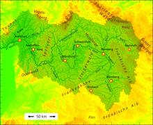
Schweinfurt is located in the middle of the German-speaking area (D-A-CH), which is why the region has become an important logistics location. Since Brexit, the center of the European Union area is 30 km southwest of the city. There are three international airports within a 120 km radius. Schweinfurt is located at the beginning of the Main Triangle, which is followed downstream by the Main Quadrangle (see middle lower figure) and is surrounded by the Haßberge, Steigerwald, Spessart and Rhön Biosphere Reserves. The city lies in a metropolitan area of high climatic contrasts, with the hot summer Main-Franconian Plates in the south and international winter sports in Oberhof in the Thuringian Forest in the north.
East and north of the city are located close to nature on the Main floodplain and the Schweinfurter Rhön (see figure on the right). The lowest point of the city area is in the southwest at the Main at 202 m above sea level, the highest in the north in the Schweinfurter Rhön at 343 m above sea level.
· 
Schweinfurt is located on the Europakanal...
· 
...in the middle of the Main River basin...
· 
...and at the northeast edge of the Schweinfurt basin
New centrality
The fall of the Iron Curtain fundamentally changed Schweinfurt's economic geography. In 2005, the A 71 Erfurt-Schweinfurt was completed as German Unity Transport Project No. 16 and Germany's most expensive motorway. The city on the Main became a central German motorway junction.
Since 2017, Berlin can be reached by train in under three and a half hours thanks to the 10 billion euro German Unity Transport Project No. 8. Even before that, it was possible to reach Munich from 2 hours 33 minutes and Hamburg from 3 hours 57 minutes via the two nearby high-speed lines with ICE stops in Würzburg and Bamberg. Berlin and Munich can be reached about three quarters of an hour faster from Schweinfurt than from Frankfurt am Main. As part of the DB long-distance traffic offensive, Schweinfurt is expected to receive a direct Intercity connection in December 2028 with the new IC Bamberg - Schweinfurt - Stuttgart - Tübingen.
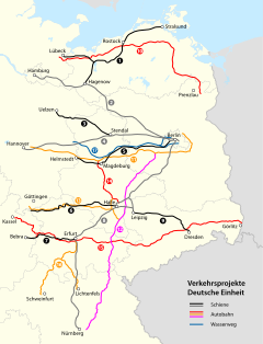
New centrality of Schweinfurt due to German reunification and new transport projects
| Dortmund 350 km | Kassel 200 km | Erfurt 160 km |
| Frankfurt a. M. 160 km |
| |
|
| 10° |
|

Berlin (City-West) via A 70: 450 km, via A 71: 442 km
The above kilometre figures refer to the distances between the city centres for journeys via motorways
Almost all federal highways with the 7 as the first digit lead in the direction of Schweinfurt or the opposite direction. 5 km west of the motorway junction Schweinfurt/Werneck the 50th degree of latitude (see above: 50°), which corresponds to the Main line and A 70, intersects the 10th degree of longitude (see above: 10°), which is identical to the north-south axis of Europe Denmark - northern Italy and the A 7. This is the only confluence point of a main latitude and main longitude in Germany (confluence monument).
Regional planning
Schweinfurt is the regional centre and capital of the Main-Rhön planning region, an otherwise rural region with 436,125 inhabitants (31 December 2019). Main-Rhön (No. 3) is one of 18 planning regions in Bavaria; it includes the independent city of Schweinfurt and the districts of Schweinfurt, Haßberge, Bad Kissingen and Rhön-Grabfeld. Main-Rhön is considered a Bavarian spa region with five spas, three of them state spas; 20 km northwest of Schweinfurt lies the former world spa Kissingen.
The conurbation area around Schweinfurt has a west-east extension of 15 kilometres from Euerbach to Forst. From north to south, it extends from Oerlenbach in the district of Bad Kissingen in a corridor along a development axis through the upper Werntal valley to Schwebheim and Heidenfeld over 23 kilometres respectively.
Natural classification
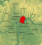
The largest area of the urban area lies in the Schweinfurt Basin (main unit 136). The north-east belongs to the mountainous natural area Hesselbacher Waldland (main unit 139), which is identical to the landscape Schweinfurter Rhön.
Geology and tectonics
The geology of the urban area ranges from the older hard limestones and marls of the Upper Muschelkalk at the bottom to the softer clayey-marly Lower Keuper (Lettenkeuper), interrupted by individual sandstones and limestone banks, to the soft mudstones of the Gipskeuper at the top. Sediments (gravel and sand) created the alluvial plain between the Main River and the Schwebheim Forest.
The tectonics of the urban area is shaped by the Kissingen-Haßfurt fault zone, which strikes north-east of the city centre from north-west to south-east and separates the uplift area of the Kissingen-Haßfurt saddle from the Schweinfurt trough.
Waters
The water areas of the city cover approx. 170 hectares (2021). Between the city centre and Sennfeld lie the Main, which is up to 170 m wide there, and two (former) tributaries: the Altarm Saumain and the Altwasser Sennfelder Seenkranz. They form a water complex up to 800 m wide. The Wern flows in an arc through the northwest of the city area and the Marienbach and Höllenbach flow into the Main from the Schweinfurt Rhön. On both sides of the southern city limits are several dredging lakes, natural lakes and Main bays with bathing opportunities. (See also: Recreation)
Schweinfurt is free of floods, as it lies at least approx. 10 metres above the water level of the Main. However, floods and heavy ice repeatedly caused major damage on the Main and in the immediate vicinity, especially in 1845 and 1909.
See also: Main islands in Schweinfurt and Main bridges in Schweinfurt
Forests, parks and protected areas
Within the city area, despite narrowly drawn political boundaries, lie relatively extensive forests (Stadtwald and Hospitalstiftung), with a total area of 1,756 hectares. The forest areas are mostly located in the northeast on the heights of the Schweinfurt Rhön, deciduous forest dominates. The Schwebheim Forest lies 100 metres lower and has a completely different character in the board-flat, winter-mild lowland south of the Main surrounded by lakes. In addition to deciduous forest, pines also occur here on the sandy soil. There are 25,000 city trees along streets and in parks, which is why Schweinfurt is considered a green city.
The fortifications are among the oldest botanical gardens in Germany and stretch for 2 kilometres along the Main, with primeval forest-like riparian forests at the edge. The old town is largely surrounded by ring parks, including the plane tree promenade at Unterer Wall. A green area is located on a mountain of rubble from the last war in the Musikerviertel, Seinäjoki Park is located at Deutschhof above Höllental, and the Baggersee recreation area is to the south (see: Recreation). The main cemetery and Willy Sachs Stadium are also park-like, with large stands of trees. Zoological gardens can be traced back in Schweinfurt to the middle of the 19th century. In 1966, the Wildpark an den Eichen was opened in the city forest with the first animal enclosures and expanded over the decades. Today, 500 animals live there on 18 hectares.
There are nine allotment garden sites with a total of 40.5 hectares. Six allotment garden associations with more than 1,000 allotment gardens are united in the city federation of allotment gardeners.
In terms of nature conservation, Schweinfurt forms one of a total of nine inner-Bavarian urban agglomerations (code number 309, 40 km²), with an effective proportion of protected areas of 3.54 %. One nature reserve, two landscape conservation areas, two FFH areas and one geotope are located in the city area.
See also: List of nature reserves in the city of Schweinfurt, List of landscape conservation areas in Schweinfurt, List of FFH areas in the city of Schweinfurt and List of geotopes in Schweinfurt
Viticulture
The local viticulture has hardly any economic but still cultural importance. The vineyards, which are free of large vineyards, with 3.54 hectares of planted vineyards (2017) belong to the Volkacher Mainschleife area of the Franconian winegrowing region. In Schweinfurt, viticulture has been practiced for over 1000 years. A monastery from Alsace ordered wine from Suinuurde in the 8th century. In the 19th century it was an important wine-growing and wine-trading town, in 1802 with about 320 hectares of vineyards. The north-eastern part of the town lies largely on former vineyards.
In 1902, phylloxera appeared in Franconia and hit the Schweinfurt area particularly hard. Since the 1980s, viticulture with the leading variety Silvaner has been practiced again in the historic vineyards Schweinfurter Peterstirn and Schweinfurter Mainleite. Due to the almost complete interruption of viticulture, the vineyards in Schweinfurt and in many places in the district of Schweinfurt, in contrast to the Würzburg and Kitzingen area, were spared from being assigned to the controversial large vineyards. The same is true for the big land consolidation of the 1970ies, with destruction of historical structures.
Climate
Precipitation is low by western German standards at just over 600 mm per year, due to the location east of the Rhön-Spessart ridge, on the leeward side (Schweinfurt dry plate). Continuous rains have always lasted a maximum of half a day. In midsummer there are often heat storms, which is why Schweinfurt became "Germany's lightning capital" in 2015 with 4.5 lightning strikes per square kilometre. With 1665 hours of sunshine (average 2014-2018), the city is in the higher range (for comparison: the sunniest German city Freiburg im Breisgau has 1740 hours of sunshine).
The winters are sometimes cold, the transitional periods relatively mild for Bavarian conditions due to the low altitude and the summers are usually warm. Spring arrives soon in the Schweinfurt basin and is very pronounced. The temperate continental climate does not occur anywhere else in western Germany, but is widespread in eastern Germany. Schweinfurt and Berlin climate corner data are almost identical.
Due to climate warming, the more severe winters that occurred until the 1980s rapidly declined. Summers became at times tropically hot, especially in the south, in the Schweinfurt basin, but have always been more moderate in the north, in the Schweinfurt Rhön, where winters tend to be more pronounced. For Schweinfurt, "a Mediterranean climate with precipitation like on the Costa Brava (400 mm) is predicted by 2050".
In the city climate, the heat island effect is mitigated by favourable topographical factors and is less than in neighbouring Würzburg, for example. Schweinfurt is not located in a basin, has a relatively large amount of green space and water and the Main valley runs in the main wind direction from east to west.
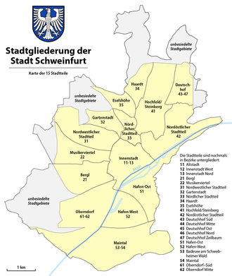
City breakdown
The city area consists almost only of the core city (reasons see: incorporation). There is no official city division, but the city area was only administratively divided into 26 statistical districts and these assigned to 15 districts (blue links on the following list). It remains unclear whether the old town also forms its own district or only a statistical district.
· 
Old Town,
Krumme Gasse
· 
City centre,
Justice centre and Kaufhof
· 
City Centre-West, Luitpoldstraße
· 
Deutschhof,Kreuzbergstraße
| Urban division and social structure | ||||
| No. | Name of statistical district/borough | Inhabitants31 | Foreigners | Dual nationals |
| 11 | Old Town | 2.529 | 17,7 | 6,9 |
| 12 | Downtown-West | 4.291 | 29,4 | 15,7 |
| 13 | Downtown North | 3.994 | 23,0 | 13,1 |
| 21 | Bergl | 9.162 | 18,8 | 23,9 |
| 22 | Musicians' Quarter | 3.103 | 20,4 | 20,1 |
| 31 | Northwestern district | 3.314 | 19,1 | 15,5 |
| 32 | Garden City | 2.787 | 6,6 | 9,4 |
| 33 | Northern district | 3.024 | 11,9 | 16,6 |
| 34 | Haardt | 1.779 | 7,4 | 17,4 |
| 35 | Donkey Heights | 2.561 | 4,3 | 13,9 |
| 41 | High field/Steinberg | 5.126 | 7,6 | 10,8 |
| 42 | Northeastern district | 2.734 | 7,4 | 8,2 |
| 43 | Deutschhof-Süd | 1.855 | 6,1 | 26,3 |
| 44 | Deutschhof-Mitte | 1.454 | 9,6 | 27,4 |
| 45 | Deutschhof East | 962 | 7,3 | 25,7 |
| 46 | Deutschhof-Nord | 963 | 6,0 | 14,6 |
| 47 | Deutschhof-Zeilbaum | 784 | 1,9 | 11,4 |
| 51 | Port East | 244 | 7,8 | 7,4 |
| 52 | Port West | 22 | 50,0 | 4,5 |
| 53 | Schweinfurt-South/Baggersee | 4 | 0,0 | 0,0 |
| 54 | Maintal | 2 | 0,0 | 0,0 |
| 61 | Oberndorf-Süd | 1.135 | 11,3 | 9,7 |
| 62 | Oberndorf-Mitte | 1.326 | 16,1 | 13,7 |
| 32.5, 36, 63 | Various peripheral areas | 47 | 2,1 | 25,5 |
| Schweinfurt total | 53.202 | 14,6 | 16,2 | |


Related articles
Author
AlegsaOnline.com Schweinfurt — city in Franconia, Germany Leandro Alegsa
URL: https://en.alegsaonline.com/art/88009
Sources
- destatis.de : "Alle politisch selbständigen Gemeinden mit ausgewählten Merkmalen am 31.12.2018 (4. Quartal)" · web.archive.org
- statistikdaten.bayern.de : "Fortschreibung des Bevölkerungsstandes"
- commons.wikimedia.org : Schweinfurt
- wikidata.org : wikidata.org/wiki/Q4126
- catalogue.bnf.fr : cb119463181
- data.bnf.fr : (data)
- d-nb.info : 4053863-1
- id.loc.gov : n81090716
- musicbrainz.org : 48b04c09-0d97-4f72-8e68-9219c159a841
- aleph.nkp.cz : ge507283
- uli.nli.org.il : 000986653
- viaf.org : 154780919
- worldcat.org : lccn-n81090716