Saxony-Anhalt
Saxony-Anhalt is a federal state in central Germany known for its historic towns, cultural heritage (Luther and Bauhaus), varied landscapes from the Elbe plains to the Harz mountains, and post‑reunification development.
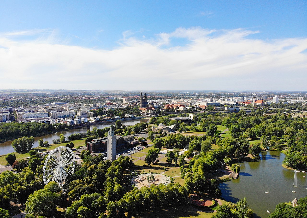
Saxony-Anhalt (German: Sachsen-Anhalt) is one of Germany’s 16 federal states (state), located in the central-northern part of the country. It lies in Germany and covers an area of about 20,445.26 km² (km2 / 7,894.0 sq mi). The state has a population of roughly 2.58 million people and its capital is Magdeburg. The region combines industrial centers, agricultural plains and low mountains, and it plays an important role in Germany’s cultural history.
Image gallery
10 Images


Geography and major cities
Saxony-Anhalt occupies a transitional zone between the North German Plain and the Harz mountains. The Elbe River is the region’s main waterway and has shaped many towns and fertile agricultural areas. Major urban centers include Magdeburg (the administrative capital), Halle (Saale), Dessau-Roßlau and Lutherstadt Wittenberg; the state also includes smaller historic towns such as Quedlinburg and Wernigerode. Landscapes vary from river valleys and broad fields to forested hills, offering both natural parks and areas of productive farmland.
History and development
The territory of today’s Saxony-Anhalt has a complex past: it comprises lands that historically belonged to different medieval principalities, bishoprics and duchies. After World War II the area became part of the Soviet occupation zone and later was included in East Germany (the GDR). Saxony-Anhalt was created in its modern form after German reunification in 1990 and has since undergone structural change, adapting its economy and infrastructure to the market economy while preserving many historic monuments.
Culture, economy and significance
The state is notable for its cultural legacy. It is closely associated with Martin Luther and the Reformation, and it hosts museums, churches and memorials tied to that history. Dessau is famous for the Bauhaus school of design, and several medieval towns and cathedrals attract visitors. Economically, Saxony-Anhalt mixes manufacturing and chemical industries with agriculture and an increasing presence of renewable energy; economic modernization and demographic change are continuing challenges and opportunities.
Notable sites and distinctions
- UNESCO World Heritage locations and historic towns such as Quedlinburg, the Bauhaus buildings in Dessau and the Luther memorials in Wittenberg.
- The Harz mountains, including protected natural areas and traditional mining landscapes.
- River landscapes along the Elbe with floodplain ecosystems and cultural routes.
Visitors and students of German history value Saxony-Anhalt for its concentration of heritage sites and its role in the Reformation and modern design movements. As a federal state it continues to balance preservation of historic resources with contemporary economic renewal and environmental management.
Geography
In the north, Saxony-Anhalt is dominated by flat land. The sparsely populated Altmark region is home to old Hanseatic towns such as Salzwedel, Gardelegen, Stendal and Tangermünde. The transition from the Altmark to the Elbe-Börde-Heide region with the fertile, sparsely wooded Magdeburger Börde is formed by the Colbitz-Letzlinger Heide and the Drömling. The towns of Haldensleben, Oschersleben (Bode), Wanzleben-Börde, Schönebeck (Elbe), Aschersleben and Magdeburg, from which the region derives its name, are located in the Magdeburger Börde.
In the southwest lies the Harz mountains with the cross-border Harz National Park, the Harz foothills and the Mansfelder Land region, as well as the towns of Halberstadt, Quedlinburg, Wernigerode, Thale, Lutherstadt Eisleben and Sangerhausen, among others.
The Halle (Saale)/Merseburg/Bitterfeld-Wolfen conurbation (also known as the "chemical triangle") is located on the border with Saxony and extends as far as Leipzig in Saxony. Since the end of the 19th and beginning of the 20th century, the chemical industry has been located here with its economic focus in Leuna.
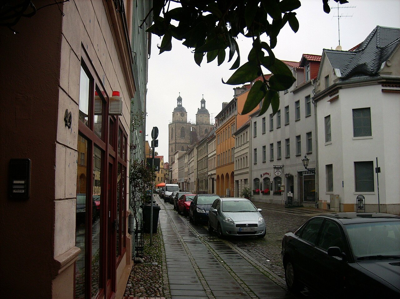
Zeitz, Naumburg (Saale), Weißenfels and Freyburg (Unstrut) are located on the Saale, the Weiße Elster and the Unstrut in the south of the state, where the Saale-Unstrut wine-growing region is located. Finally, Saxony-Anhalt also includes the Anhalt-Wittenberg region in the east, with the third largest city in the state, Dessau-Roßlau, which emerged from the old Anhalt residence city of Dessau, the Lutherstadt Wittenberg and part of the Fläming region.
Regions
- Altmark
- Anhalt
- Anhalt-Wittenberg
- Chemistry Triangle
- Magdeburg region
- Resin
- Mansfeld region
- Eastphalia
- Saale-Unstrut region
Landscapes
- Altmark with
- Colbitz-Letzlinger Heath
- Drömling
- Elbe lowlands with
- Central Elbe Biosphere Reserve
- Dessau-Wörlitz Garden Realm
- Fiener Bruch
- Magdeburg Börde
- Northern Harz foreland with
- Large halyard
- Hakel
- Huy (mountain range)
- Big break
- Harz / Harz National Park
- Lower Saale Valley Nature Park
- Fläming / Fläming Nature Park
- Düben Heath Nature Park
- Nature Park Saale-Unstrut-Triasland with
- Querfurt plate
- Golden Meadow
- Kyffhäuser
- High Schrecke
- Karow Plate
Low mountain ranges and mountains
The largest low mountain range in Saxony-Anhalt is the Harz, which is also home to the highest elevation in Saxony-Anhalt and all of northern Germany. This is with 1141.1 m above sea level the Brocken.
See also: List of mountains and elevations in Saxony-Anhalt
Waters
Overall, the waters in Saxony-Anhalt are in a poor condition. The high amounts of slurry from factory farming are causing problems for the water bodies. Only in Saxony are the waters in a worse state.
Rivers
The following rivers and/or streams flow through Saxony-Anhalt in whole or in part. Known flowing waters (with respective total length) are:
|
Lakes
Saxony-Anhalt originally had only a few lakes. Where salts occur underground, representatives such as the Arendsee in the Altmark and the Mansfeld lakes Süßer- and Salziger See were formed by subsidence of the earth. The majority of the larger lakes in Saxony-Anhalt, on the other hand, are man-made. Most of them were created by the renaturation of old opencast pits from lignite mining. The following list gives an overview of the largest lakes in Saxony-Anhalt:
|
|
Dams
Muldestausee, Rappbode dam, Kelbra dam, Wippertal dam


History
For the history of the area before 1944, see, among others, Altmark, Archdiocese of Magdeburg, High Diocese of Halberstadt, Quedlinburg Abbey, Province of Saxony and Anhalt, for the main article, see History of Saxony-Anhalt.
In July 1944, the former Prussian province of Saxony, consisting of the administrative districts of Magdeburg, Merseburg and Erfurt, was divided. The provinces of Magdeburg and Halle-Merseburg were created. The administrative district of Erfurt was subordinated to the Reich Governor of Thuringia. After the German capitulation in 1945 the Soviet Military Administration in Germany (SMAD) united the two provinces Magdeburg and Halle-Merseburg, furthermore the Free State of Anhalt (around Dessau), the former Brunswick exclave Calvörde and the eastern part of the district Blankenburg in the Harz, also previously belonging to the state of Brunswick, as well as the Thuringian enclave Allstedt to the new province Saxony and the name was changed to province Saxony-Anhalt in October 1946. In the course of the dissolution of Prussia, the province of Saxony-Anhalt proclaimed its own state constitution on 10 January 1947. On 21 July 1947 it was renamed the Land of Saxony-Anhalt. The state capital became Halle. The state covered 24,576 km².
In July 1952, as part of the administrative reform in the GDR, the state of Saxony-Anhalt was de facto dissolved (de jure it continued to exist for a few years) and divided into the two districts of Halle and Magdeburg. In the process, border adjustments were made, in which individual towns and municipalities were incorporated by the neighbouring districts or hived off to them, whereby the district borders shifted in relation to the former state borders.
On October 3, 1990, the state of Saxony-Anhalt was re-established by the Land Introduction Act. Since then, Saxony-Anhalt has once again consisted of the former districts of Halle (without the district of Artern) and Magdeburg as well as the district of Jessen, which had already belonged to Saxony-Anhalt before 1952. Magdeburg became the state capital. Saxony-Anhalt's partner state during the construction of the new structures was Lower Saxony. The early 1990s were marked by frequent changes of state governments and political affairs. As a result, the initially ruling CDU lost the second state elections after reunification and a state government of SPD and Bündnis 90/Grüne tolerated by the PDS came into being (Magdeburg model). Prime Minister Reinhard Höppner governed the state for two legislative periods in a time of great economic and labour market restructuring, after the Greens left in a PDS-tolerated SPD-alliance government. Saxony-Anhalt had to cope with the highest unemployment rate of all federal states. In the third election period since reunification, the extreme right-wing DVU succeeded in entering the Landtag. However, this group soon broke up over internal disputes and was not re-elected to the Landtag in 2002. The continuing economic crisis led to another change of government in the 2002 elections. Since then, Saxony-Anhalt has been governed initially by a CDU/FDP government, then by a CDU/SPD government under Wolfgang Böhmer. After the state elections in 2011, he was replaced by Reiner Haseloff for reasons of age, who in turn has led a so-called Kenya coalition since 2016.
Cultural history
The area of what is now Saxony-Anhalt was one of the cultural focal points in the German-speaking world in the early Middle Ages. Today's state capital Magdeburg was one of the political centres in the Holy Roman Empire of the German Nation at that time. Today, the well-preserved architectural monuments typical of the state from the Romanesque and Gothic periods (see also: Romanesque Road), such as the cathedrals of Magdeburg and Halberstadt, the old town of Quedlinburg and many castles and churches, bear witness to the former importance of the entire region. According to the state marketing association, Saxony-Anhalt is the state with the highest density of UNESCO World Heritage Sites in Germany. These include the Bauhaus Dessau in Dessau-Roßlau, the Luther memorials in Wittenberg and Eisleben, the old town of Quedlinburg, the Dessau-Wörlitz Garden Realm with the Wörlitz Park and Naumburg Cathedral. Characteristic of the local villages and towns are, in addition to winding half-timbered old towns and closely built villages, also often with half-timbered architecture and old village churches worth seeing, also buildings from the time of the Prussian province of Saxony, which at the time was considered the richest province in the country.


Related articles
Author
AlegsaOnline.com Saxony-Anhalt Leandro Alegsa
URL: https://en.alegsaonline.com/art/87698