Santorini: Greek island of the Cyclades and volcanic caldera
Santorini is a volcanic island in the southern Aegean Sea, noted for its caldera, whitewashed towns, Bronze Age archaeology, viticulture and popular tourism; capital: Thira (Fira).
Overview
Santorini is a Greek island in the Cyclades archipelago of the southern Aegean Sea. Its capital is Thira (often spelled Fira). The island lies roughly 63 miles from Crete and has a permanent population of around 13,600. Santorini is widely known as the remnant of a volcanic caldera and is one of the most visited islands in Greece.
Image gallery
10 Images


Geography and volcanic character
The modern island occupies the rim of a submerged caldera formed when a large volcanic eruption caused the central part of the island to collapse. The crescent of high cliffs that faces the caldera contains villages, harbors and terraces. Santorini is considered an active volcano, and eruptions in antiquity and the modern era have shaped its coastlines and geology.
History and archaeology
One of Santorini's most important archaeological sites is Akrotiri, a Bronze Age settlement preserved under volcanic ash. The island's major prehistoric eruption, often dated to the second millennium BCE, had significant regional effects and is a subject of ongoing research. Later history includes medieval and Venetian periods that helped shape local architecture and settlement patterns.
Towns, architecture and culture
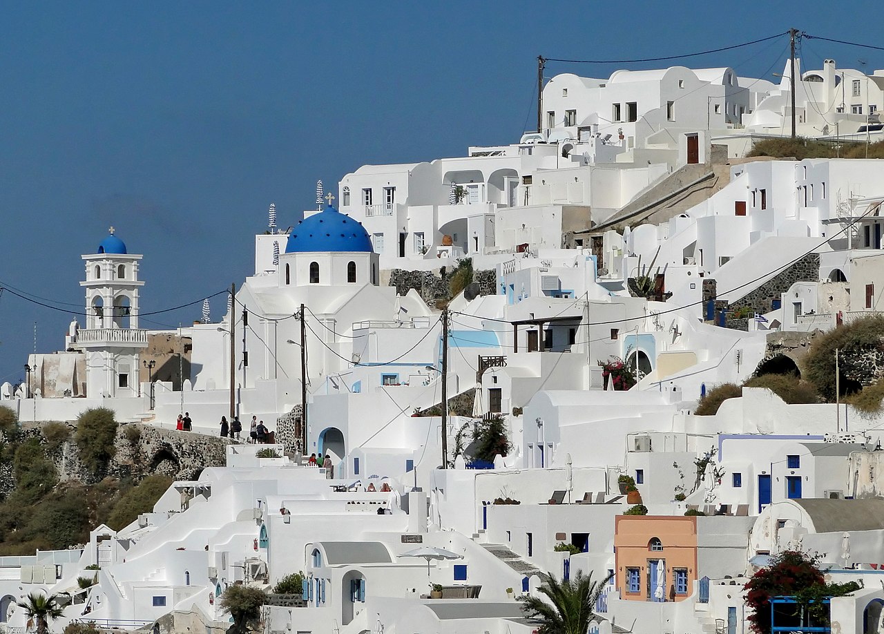
Settlements such as Fira and Oia are famous for whitewashed houses, narrow lanes, blue-domed churches and cliffside views over the caldera. Traditional building techniques, stone terraces and windmills are common. Local culture blends maritime, agricultural and tourism influences, and festivals often celebrate wine and religious traditions.
Economy, wine and tourism
Tourism is the island's dominant economic activity, with visitors attracted by volcanic landscapes, sunsets, archaeological sites and beaches that range from red and black sand to pebbled coves. Santorini also has a noted viticulture: hardy local grape varieties, such as Assyrtiko, are grown on volcanic soils and produce distinctive dry white wines that are important to the island's economy.
Notable facts and travel links
- Santorini forms part of the Cyclades group and is administered as a regional unit of Greece. For administrative and visitor information see local administration.
- The island's volcanic caldera is a key natural attraction; geological and safety information can be found at volcanic/visitor resources.
- Ferry and sea connections link Santorini with other islands and with Crete; schedules and routes are commonly listed through regional transport providers such as Crete and island services.
Santorini's mixture of dramatic geology, preserved antiquity, distinctive architecture and vibrant tourism makes it a widely recognized destination in the Mediterranean. Visitors and researchers alike come for its landscapes, archaeological heritage and unique agricultural products.
Location and geography
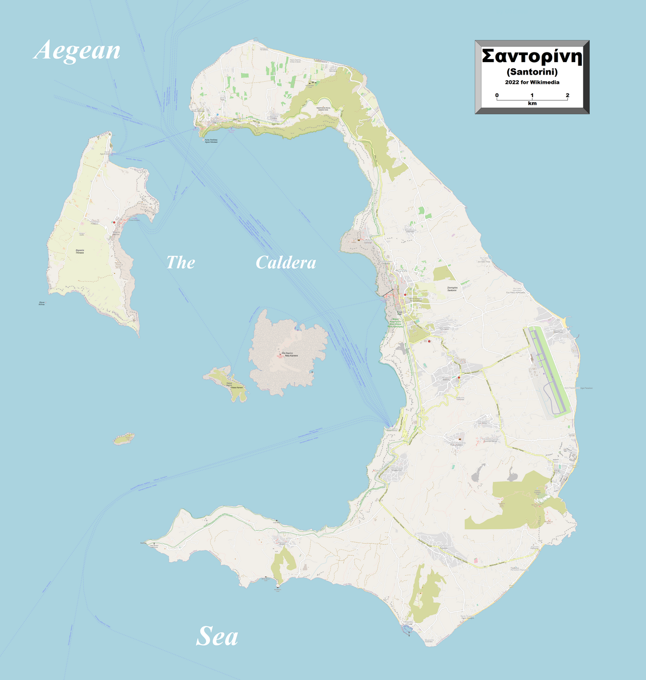
The Santorini archipelago is located in the southern Aegean Sea about 120 km north of Crete. The nearest islands are Anafi 22 km to the east and Ios 19 km to the north; Milos is about 77 km to the northwest.
The islands of Thira, Thirasia and Aspronisi, arranged in a ring, form the edge of a caldera flooded by the sea, in the centre of which lie the islands of Palea Kameni and Nea Kameni. The entire archipelago has a diameter of about 16 km. The total area is about 92.5 km². Due to the geological development, the Christiana Islands and the underwater volcano Kolumbos also belong to the Santorini archipelago.
From the 150 to 350 m high caldera wall, the slope of Thira and Thirasia is gentle towards the outside. Only in the southeast of Thira the Profitis Ilias massif, with 567 m the highest elevation of the archipelago, interrupts this gentle slope. In many places a wide black lava beach forms the transition to the sea. In other places the pumice reaches the sea and forms cliffs. On Thira, with the exception of the Profitis Ilias massif, and on Thirasia, deep erosion gullies in the soft pumice cover, caused by winter rains, characterize the topography.
The maximum extent of the main crescent-shaped island of Thira is 17.4 km from Cape Mavropetra (Ακρωτήριο Μαυρόπετρα Akrotirio Mavropetra) in the north to Cape Exomytis (Ακρωτήριο Εξωμύτης Akrotirio Exomytis) in the south. The width varies from 1.2 km in the north to about 6 km in the south. About 70% of the island's surface is covered by layers of pumice, some of which are massive. In the north these layers are interrupted by older volcanoes, in the south by older lava domes. Lava and cinders and the metamorphic basement each account for 15 %.
The caldera of Santorini covers an area of about 84.5 km², the extension in north-south direction is about 11 km, in west-east direction almost 8 km. The absolute height is about 700 m in the north of Thira from the sea bottom. The caldera floor consists of four sub-basins. The northeastern sub-basin reaches a depth of almost 400 m and was probably formed with the processes of the Minoan eruption.
f1![]() Map with all coordinates: OSM | WikiMap
Map with all coordinates: OSM | WikiMap
| The individual islands | ||||
| Name | Greek name | surface km² | Height | Location |
| Thira | Θήρα (f. sg.) | 79,1940* | 567 | 36° 24′ N, 25° 27′ O36.403599625.4563522 |
| Thirasia | Θηρασία (f. sg.) | 9,2460* | 295 | 36° 26′ 8″ N, 25° 20′ 21″ O36.435577725.3391933 |
| Nea Kameni | Νέα Καμένη (f. sg.) | 3,3380* | 127 | 36° 24′ 16″ N, 25° 23′ 50″ O36.404359525.3973007 |
| Palea Kameni | Παλαιά Καμένι (f. sg.) | 0,5250* | 98 | 36° 23′ 52″ N, 25° 22′ 49″ O36.397658425.3802204 |
| Aspronisi | Ασπρόνησι (n. sg.) | 0,1420* | 70 | 36° 23′ 1″ N, 25° 20′ 53″ O36.383494325.3481197 |
| Aghios Nikolaos | Άγιος Νικόλαος (m. sg.) | 0,003*0 | 36° 27′ 27″ N, 25° 22′ 20″ O36.457369525.3722703 | |
| Kimina | Κίμινα (n. pl.) | 0,0005* | 36° 25′ 2″ N, 25° 19′ 26″ O36.417216125.3238189 | |
* Estimated area


Geology
In the Pliocene, about three million years ago, movements at the plate margins caused the collapse and flooding of the Cyclades Massif. At the southern margin, the subduction of the AfricanPlate under the Aegean Plate led to the melting of the crustal material and the formation of a volcanic island arc. The Santorini archipelago lies in the central area of this so-called Cycladic arc.
The base of the Santorini archipelago is formed by a non-volcanic basement of Upper Triassic reef limestones and Tertiary phyllites, partly metamorphosed into marble. At Athinios, granite intruded these metamorphic rocks during the Upper Miocene. The main part of the Santorini archipelago is formed by several volcanic complexes that partially overlie the basement.
This basement formed a non-volcanic island as a remnant of the Cyclades massif and extends from the Profitis Ilias massif and the Gavrilos hills in the southeast to the caldera wall at Athinios and Cape Thermia in the west. Volcanic activity began about 1.6 million years to 600,000 years ago. An eruption center southwest of the Cyclades massif formed a new island, and the existing one was partially covered. Another volcano formed to the north of Thira 500,000 years ago, while further activity to the south united the volcanic and non-volcanic islands. Two violent eruptions 200,000 and 180,000 years ago produced a layer of pumice up to 70 m thick and overlaid the previous volcanoes. Due to the emptying of the magma chamber, a volcanotectonic collapse occurred and the first caldera was formed.
A total of twelve explosive eruptions with a VEI value of 5 or higher (a VEI value of 7 is discussed for the Minoan eruption) produced the main quantity of volcanic products in the past 200,000 years. Active phases were followed by periods of quiescence; on the basis of charred plant remains, it has been possible to demonstrate the formation of soil during longer periods of quiescence. The shape of the archipelago changed several times. Powerful eruptions were followed four times by the formation of a caldera. This repeated alternation of volcanic formation and volcanotectonic collapses can be traced today in the northern part of the caldera. As a result of three explosive eruptions, the Skaros caldera was formed less than 100,000 years ago, the Cape Riva caldera 21,000 years ago, and the present caldera about 3600 years ago, caused by the Minoan eruption. In its aftermath, submarine eruptions with lava outflows started near the center of the caldera and built up the Kameni volcano with the islands of the same name from the caldera floor in 500 m sea depth in several phases during the past 2200 years.
With three eruptions in the 20th century, Kameni volcano is the most active volcano (besides Nisyros) in the eastern Mediterranean.
Historical and current observation of volcanic activity
The volcanic activity in the caldera of Santorini and the formation of the Kameni Islands were already reported by ancient scholars such as Strabon, Plutarch and Pausanias, and numerous observations have been handed down. The descriptions of the formation of Nea Kameni from 1570 onwards are particularly well known. The French geologist Ferdinand André Fouqué followed the eruptions of Nea Kameni for several months in 1866 and wrote a monograph about them. Hans Reck published a comprehensive work on the eruption period from 1925 to 1928. In contrast, the older islands of Thira and Thirasia received little attention for a long time. The discovery and excavation of Akrotiri raised initial questions; since the 1960s, the formation of the older islands has been the subject of international research.
In the summer of 1995, the Institute for the Study and Observation of the Santorini Volcano (I.S.M.O.SA.V.) began work as part of an EU-funded volcano monitoring research programme.
Since 9 January 2011, a new phase of volcanism began on Santorini with swarming earthquakes and a bulging of the island. A group of researchers led by Andrew Newman set up a network of ten seismographs and about 20 GPS stations since 2006. According to the team's calculations, the intrusion of a magma mass of about 14 million m³ below Santorini is the cause of the uplift of 5 to 9 cm and the seismic activity. Stations on opposite sides of the caldera also moved 14 cm apart. It is unclear if and when a new volcanic eruption will actually occur; however, scientists believe an eruption is likely in the next few years. However, observations of similar calderas around the world show that such phases of uplift and subsidence, and even the intrusion of a magma body, do not automatically have to result in timely volcanic eruptions. The next eruption may take place in years or decades.
Minerals and rare rocks
Due to its diverse geological structure, Santorini is rich in different rocks, each of which can contain interesting minerals.
In the volcanic rocks basalt, dacite, pumice and tuff there are gas bubbles, which offered cavities for the formation of minerals. In them you can find, among other things, quartz crystals and zeolites (natrolite, chabasite).
In volcanic rocks that have been hydrothermally altered and are silicate-rich, chalcedony, quartz, agate, and opal (usually as hyalite) are found.
Very rarely, secondary rocks may have entered a magma chamber and been metamorphosed there, forming skarn. Garnet and pyroxene crystals (up to 3 cm) can be found in it.
In the area of the older bedrock, which can be found for example at the port of Athinios (slate, marble and dolomite), there are mineralizations that are bound to old tectonic faults. These are recognizable by distinct black or reddish veins. The following minerals can be found there: galenite/leucite (up to 3 cm large inclusions), cerussite, linarite (very rare), malachite, dolomite crystals, chalcopyrite (mostly as limonitized pseudomorphs).
Fossils
The ash layers of the volcanic eruptions have sometimes preserved plant remains that until recently could be found in the former pumice quarry near Thira. These included palm leaves, terebinth leaves and olive leaves. These finds are about 30,000 to 60,000 years old. Currently, the site, which is actually a natural monument of the highest importance worthy of protection, is being filled in with rubbish.
The most recent fossils are in the boundary layer to the Minoan volcanic eruption. For example, Tom Pfeiffer found a charred olive tree there that helped date the Minoan catastrophe.
Much older, on the other hand, are the fossils at the Profitis Iias summit from the Cretaceous period, where there is mainly deep-sea fauna from around 120 to 150 million years ago, for example with hippurites.


Related articles
Author
AlegsaOnline.com Santorini: Greek island of the Cyclades and volcanic caldera Leandro Alegsa
URL: https://en.alegsaonline.com/art/87212
Sources
- vulcan.wr.usgs.gov : "Decade Volcanoes"