Sanday, Orkney
![]()
The title of this article is ambiguous. For other meanings, see Sanday (disambiguation).
Sanday (Engl. "sand island") belongs to the Scottish Orkney Islands. It lies about 28 km northeast of the island's capital Kirkwall. The name of the almost treeless, flat island (the highest elevation is 66 m) comes from the Vikings and refers to the island's sandy beaches.
With a length of 20 km at a maximum width of 8.5 km, it is the largest of the northern Orkney Islands with an area of 50.43 km². The coastline is very long due to narrow headlands and deep cutting bays. Sanday has a mild climate (temperatures between 0 and 20 °C), but is exposed to strong winter storms. The island is surrounded by several groups of small uninhabited islands (Holmes) (Holms of Ire, Holms of Spurness), which are bird havens and seal sanctuaries.
In 2011 Sanday had a population of 494. The main population centres are Kettletoft, where the ferry docked until 1992, and Roadside, also known as "Lady Village". Most residents live in scattered houses. Sanday has two general stores, a church, a doctor's office, two nurses, a school, two pubs, a small museum, a bicycle shop, two auto repair shops, a "Village Hall" at the school, and a small indoor swimming pool. The school offers kindergarten, seven primary grades and four secondary grades. Island children spend their final school years at the school in Kirkwall and can stay in a special school hostel during the week. During the 1870s the island had its highest population of around 2500 residents. A relic of this time is the abandoned village of Ortie, located in the north.
The main economic activities are agriculture (mainly livestock farming), coastal fishing, especially for mussels, crabs and lobsters, and increasingly tourism.
The island's most famous resident was the composer Sir Peter Maxwell Davies (1934-2016). The fact that the Orkney Islands Council prohibited the local registrar from marrying Davies to his partner Colin Parkinson on their home island attracted international attention in 2007.
Traffic
There are regular ferry services from Loth to Kirkwall and the neighbouring island of Eday. Other neighbouring islands (Westray, Papa Westray, Stronsay and North Ronaldsay) are occasionally accessible by ferry in summer. There are also daily scheduled flights to Mainland and Stronsay. Due to the distances involved, it is difficult to see all the sights on Sanday in a day visit.
On Sanday there is a public minibus service that takes passengers to and from the ferry by order.
Rental bicycles are available.
Places of interest
Besides the natural beauties such as the rare plants and the sandy beaches often populated by seals, there are numerous archaeological sites.
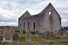
Neolithic settlement is evidenced by Quoyness Cairn on the Elsness Peninsula, a Maeshowe-type structure. Dating from the 3rd millennium BC, the site is very well preserved and has an internal height of about four metres. The island has three other megalithic sites, of the Stalled Cairn type. To the northeast is the Toftsness burial ground, with over 800 barrows. It is one of the largest prehistoric burial sites in northern Europe. At the end of Tresness headland lie the Broch of Wasso. At the Old Lady Kirk there are the prehistoric "Ladie's Fingers", (grinding grooves). Other structures and burial grounds, most of which have not been excavated, date from the Stone, Iron and Viking Ages.
Among the spectacular finds is the Viking boat grave of Scar or Quoy Banks, uncovered by the storm in 1985, with grave goods such as a brooch, sword, sickle and spindle whorls. A whalebone plaque, the Scar Dragon Plaque, is particularly fine (all finds are now in Kirkwall Museum). Nearby is the Stone o' Scar.
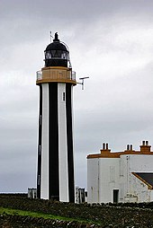
To the east is the lighthouse of "Start Point", built in 1802, which is separated from the main island at high tide. On the peninsula of Tresness, to the south lies the farm of the same name with the well-preserved Horse Energie House, a hexagonal stone structure with a pyramid roof, where horses generated the energy to run the farm. An example of an attempt to generate the necessary energy by a steam engine is the now derelict Stove Model Farm to the south. The operator failed because the cost of the fuels coal and peat, which are not available on Sanday, was too high.
Two hotels, a hostel with space for caravans and tents, several accommodations and holiday apartments are available for guests.

Lighthouse "Start Point

Ruin of the Lady Kirk
Questions and Answers
Q: Where is Sanday located?
A: Sanday is located in Orkney, Scotland.
Q: What is the size of Sanday?
A: The area of Sanday is 50.43 square kilometres (19.5 sq mi).
Q: How does one get to Sanday?
A: Sanday can be reached by Orkney Ferries or plane from Kirkwall on the Orkney Mainland.
Q: What are the main centres of population in Sanday?
A: The main centres of population in Sanday are Lady Village and Kettletoft.
Q: What activities does Sanday offer?
A: Cultural activities in Sanday revolve around the school.
Q: Is Sanday the largest island in Orkney?
A: No, Sanday is the third largest of the Orkney Islands.
Q: Is Sanday an uninhabited island?
A: No, Sanday is one of the inhabited islands of Orkney.
Search within the encyclopedia