
San Andreas Fault
Major transform fault in California marking the Pacific–North American plate boundary; site of large historic earthquakes and an active area of study and hazard.
Overview
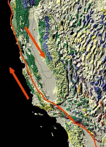
The San Andreas Fault is the principal transform boundary between the Pacific Plate and the North American Plate in California. It is a right-lateral, or dextral, strike-slip fault system: if one stands on one side and looks across, the opposite side appears to move to the right. The feature is not a single crack but a broad zone of broken and offset rock that stretches roughly northwest–southeast across the state and links to spreading centers and fault systems farther south and offshore.
Image gallery
10 Images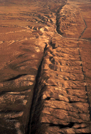





Structure and segments
The fault zone consists of several parallel strands and subsidiary faults rather than one simple, continuous line. It extends from northern coastal California near Cape Mendocino to the Salton Sea and the northern reaches of the Gulf of California, where it merges with areas of crustal spreading. In northern and central California the system threads offshore and onshore through bays and mountain ranges, making visible offsets in landscapes, reservoirs, and urban infrastructure. For example, the fault comes onshore near Daly City and passes through the Santa Cruz Mountains, while south of San Jose it trends through agricultural valleys and foothills toward southern California.
History and notable earthquakes
The modern San Andreas system began to develop in the early to middle Miocene; many estimates place its origin at about 20 million years ago as the plate boundary evolved. Its most famous rupture produced the devastating 1906 San Francisco earthquake, which extensively damaged San Francisco and surrounding communities. More recent large events attributed to strands of the system include the 1989 Loma Prieta earthquake in the Santa Cruz Mountains. Other parts of the overall plate boundary produce seismicity beneath the Los Angeles region and the Sea of Cortez; the fault network interacts with many regional structures, including strands that run under the Los Angeles Basin.
Surface expression and creep
In places the fault produces dramatic surface offsets: scarps, shifted river channels, and disrupted roads and fences. Some segments are locked and accumulate elastic strain until they rupture in earthquakes; others slowly slip at the surface in a process called fault creep. The town of Hollister is a well-known example where creeping strands have displaced sidewalks, curbs, and foundations. The fault’s surface track also controlled local landscape features and artificial reservoirs—Crystal Springs Reservoir, for example, lies along a fault-influenced valley.
Scientific study and monitoring
Geologists first recognized and described the fault in the late 19th century; field studies and mapping by scientists such as Andrew Lawson documented its offset rocks and distinctive geology. Lawson noted faulted serpentinite in an area later associated with the Golden Gate approaches; anecdotal accounts mention the exposure of this serpentinite near where the Golden Gate Bridge south tower was later placed. Since those early surveys, advances in paleoseismology, GPS and InSAR geodesy, and seismic networks have greatly improved knowledge of slip rates, segment behavior, and earthquake history, while continuing to refine models of earthquake likelihood and ground shaking.
Hazards, preparedness, and significance
The San Andreas Fault is central to earthquake hazard in California. Large ruptures can generate strong shaking, landslides, surface rupture, and secondary effects such as fires and infrastructure failure. Because urban areas, transportation corridors, and critical utilities cross or lie near the fault zone, planning and preparedness—building codes, retrofitting, early warning systems, and public education—are important components of risk reduction. Scientists emphasize that different strands behave differently: some are mature sites for major earthquakes while others relieve stress gradually. Understanding that variability is crucial for realistic hazard assessments.
Key facts and distinctions
- The San Andreas is a transform, right-lateral (strike-slip) plate boundary linking northern and southern California tectonics.
- It is a multi-stranded zone several miles wide in places rather than a single narrow rupture.
- Historic ruptures include the 1906 and San Francisco event and the 1989 Loma Prieta earthquake; other earthquakes occur on nearby faults and under urban basins like the Los Angeles Basin.
- Some portions creep slowly at the surface (notably near Hollister), while other portions are locked and prone to larger events.
- Geological study began in earnest in the 1890s, with fieldwork documenting offset rocks such as serpentinite near early construction sites (including the Golden Gate Bridge south tower area).
Contemporary work continues to combine field mapping, trenching, and high-precision geodesy to refine where and how the fault might rupture next. For residents, planners and scientists alike, the San Andreas remains both a fundamental feature of California’s landscape and a focus for ongoing research and preparedness efforts.
Questions and answers
Q: What type of fault is the San Andreas Fault?
A: The San Andreas Fault is a right-moving ('dextral') strike-slip fault.
Q: What plates does the San Andreas Fault mark the boundary between?
A: The San Andreas Fault marks the boundary between the North American Plate on the east and the Pacific Plate on the west.
Q: When did the San Andreas Fault first appear?
A: The San Andreas Fault first appeared about 20 million years ago.
Q: Where does it run from Cape Mendocino to?
A: From Cape Mendocino, it runs offshore to Tomales Bay.
Q: Who discovered the San Andreas Fault in 1895?
A: The San Andreas fault was discovered by Andrew Lawson in 1895.
Q: What event happened at Crystal Springs reservoir that was caused by this fault?
A: Crystal Springs reservoir is formed by the fault itself.
Q: Where did 1989 Loma Prieta Earthquake occur? A:The 1989 Loma Prieta Earthquake occurred in Santa Cruz mountains, where it bends slightly eastward.
Related articles
Author
AlegsaOnline.com San Andreas Fault Leandro Alegsa
URL: https://en.alegsaonline.com/art/86765