
Saipan: Island and Capital of the Northern Mariana Islands
Saipan is the largest island and administrative center of the U.S. Commonwealth of the Northern Mariana Islands, known for its tropical scenery, WWII history, Chamorro and Carolinian cultures, and tourism economy.
Overview — Saipan is the largest island and the capital of the United States Commonwealth of the Northern Mariana Islands. It lies in the Marianas archipelago in the western Pacific Ocean. The island is often described by its tropical beaches, limestone cliffs, and a complex history shaped by indigenous Chamorro culture, periods of foreign rule, and intense fighting during World War II. For pronunciation and audio references see pronunciation. Saipan is sometimes referenced simply as the CNMI capital or the Marianas' main tourism hub.
Image gallery
10 Images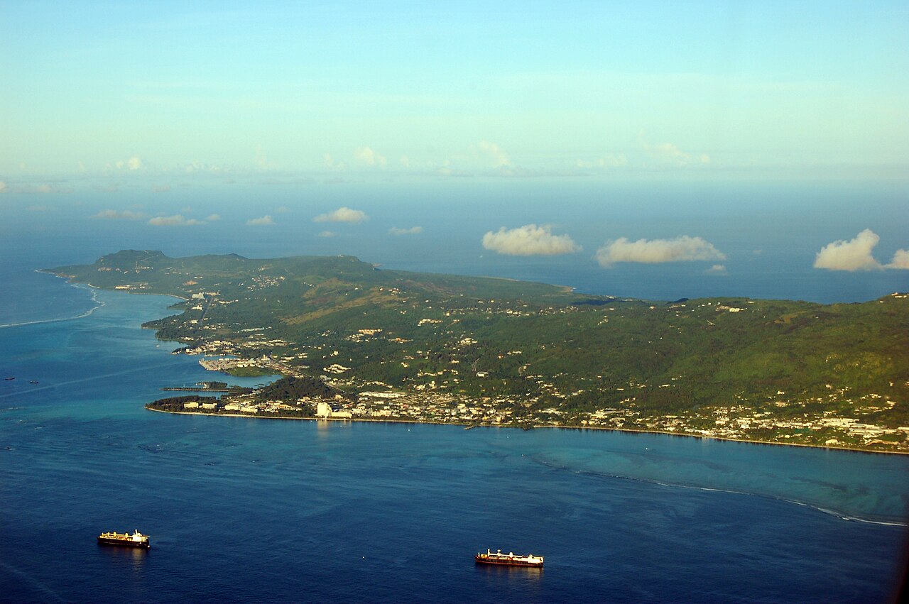


Geography and environment
Saipan occupies roughly 115 square kilometres and stretches about 20 km long by 9 km wide. Its coordinates are near 15.25° north latitude and 145.75° east longitude. The island sits approximately 200 km north of Guam. The terrain combines a central plateau and low hills with fringing coral reefs, sandy beaches, and steep limestone cliffs along parts of the coast. The broader island chain and regional setting are described on resources about the Marianas archipelago and the western Pacific Ocean. Maps and area statistics are available via general geographic references area details.
History and development
Saipan's earliest inhabitants were the Chamorro people, whose settlements and customs shaped the island long before European contact. Over centuries the Marianas experienced Spanish colonization, later German administration, and then Japanese control in the early 20th century. Saipan became a major battleground in 1944 when Allied forces captured the island from Japan; remains and memorials from that period are still prominent. After World War II the island entered trusteeship under the United Nations administered by the United States and eventually formed a political union as the Commonwealth of the Northern Mariana Islands. For context on the island's political relationship see references to the United States and the CNMI.
Population, culture and economy
At the 2000 census Saipan was reported to have more than 62,000 residents, but population figures have varied in later counts due to migration and economic changes. The island's communities include indigenous Chamorro and Carolinian peoples, and significant Filipino, Chinese, Korean and other Pacific Islander populations; multiple languages are used alongside English. The local economy relies heavily on tourism, government services, and supporting industries such as retail and hospitality; garment manufacturing was once a notable sector. Local culture blends traditional Pacific island customs with influences from East Asia and the United States.
Tourism and notable sites
Visitors come for snorkeling, diving, beaches, and World War II landmarks. Prominent sites include:
- American Memorial Park and other commemorative sites honoring WWII events;
- Banzai Cliff and Suicide Cliff, steep limestone promontories with wartime history;
- Managaha Island, a small offshore islet popular for swimming and day trips;
- Mount Tapochau, the island's highest point with panoramic views.
Natural attractions, reef snorkeling and local festivals also draw visitors; practical travel information and visitor services are commonly listed through regional tourism portals and guides island information.
Climate, transport and governance
Saipan has a tropical marine climate with relatively stable temperatures year-round, a wetter season and a risk of tropical storms and typhoons. The island functions as the political and administrative center of the Commonwealth, hosting government offices and services. Main transport links include Saipan International Airport and ferry connections to nearby islets; Guam lies to the south and is the nearest major regional hub. For location specifics see references to latitude coordinates, longitude references, and distance to Guam.
Notable facts: Saipan combines scenic Pacific island landscapes with layered histories that are visible in its cultural life and preserved sites. It remains an important center for the Northern Mariana Islands, balancing tourism, local traditions and its political association with the United States.
Questions and answers
Q: What is Saipan?
A: Saipan is the largest island and the capital of the United States Commonwealth of the Northern Mariana Islands (CNMI), which is a chain of 15 tropical islands in the western Pacific Ocean.
Q: Where is Saipan located?
A: Saipan is located at a latitude of 15.25° north and a longitude of 145.75° east, about 200 km (120 mi) north of Guam, and it is part of the Marianas archipelago in the western Pacific Ocean.
Q: What is the total area of Saipan?
A: Saipan has a total area of 115.39 km² (44.55 sq mi).
Q: How many people lived in Saipan at the 2000 census?
A: At the 2000 census, there were over 62,392 people living in Saipan.
Q: How long and wide is Saipan?
A: Saipan is about 20 km (12.5 mi) long and 9 km (5.5 mi) wide.
Q: Is Saipan a popular tourist destination?
A: Yes, Saipan is a popular tourist destination in the Pacific.
Q: What is the pronunciation of Saipan in English?
A: The pronunciation of Saipan in English can be [saɪ'pæn], [saɪ'pɑn], or ['saɪpæn].
Related articles
Author
AlegsaOnline.com Saipan: Island and Capital of the Northern Mariana Islands Leandro Alegsa
URL: https://en.alegsaonline.com/art/86349
Sources
- census.gov : Census Bureau Releases, Census 2000 Population Counts for the Commonwealth of the Northern Mariana Islands
- wikidata.org : wikidata.org/wiki/Q51679
- d-nb.info : 4436338-2
- id.loc.gov : n85830728
- musicbrainz.org : c27f30b5-263e-4d2d-abf5-b187fa322c14
- catalog.archives.gov : 10044468
- id.ndl.go.jp : 00628523
- viaf.org : 153685073
- worldcat.org : lccn-n85830728