Saint-Gilles (Sint-Gillis): a Brussels municipality and urban quarter
Saint-Gilles (Sint-Gillis) is a densely populated municipality in the Brussels-Capital Region of Belgium, known for 19th-century rebuilding, diverse architecture and the Brussels-South transport hub.
Overview
Saint-Gilles (French) or Sint-Gillis (Dutch) is one of the nineteen municipalities that make up the Brussels-Capital Region. It lies immediately south of the historic centre of Brussels in Belgium and functions as a compact, mixed-use urban quarter. Administratively independent as a municipality, Saint-Gilles is noted for its relatively high population density, a varied building stock and its role as a transport and cultural crossroads within the Brussels metropolitan area.
Image gallery
5 Images


Historical development
For much of its early history Saint-Gilles was a village on the outskirts of Brussels. The character of the area changed decisively after 1830, when Brussels became the capital of the newly independent Belgian state. Rapid urban expansion followed: a mostly rural place of some 2,500 inhabitants around 1800 grew into a dense urban municipality by the late 19th and early 20th centuries. Available records indicate a rise to over 33,000 inhabitants by 1880 and a reported peak of roughly 60,000 around 1910.
The mid-19th century remodeling of Saint-Gilles was part of wider changes in Brussels' urban fabric. In the 1860s the municipal street plan and public works were reshaped under the direction of urban planners and engineers, among them Victor Besme. Major infrastructure and civic projects associated with that period included the creation of new boulevards such as Avenue Louise, the construction of the new Brussels-South railway station, and the erection of prominent public buildings and churches. These interventions converted former rural land into an urban grid of streets, squares and transit facilities.
Characteristics and notable places
Saint-Gilles mixes residential blocks, small shops, cultural venues and administrative buildings. The late 19th- and early 20th-century construction boom left a rich variety of architectural styles: dense townhouse rows, eclectic façades, and examples of Art Nouveau and Beaux-Arts detailing common to Brussels of that era. The municipality also hosts important civic institutions built during its period of rapid growth.
- Transport: the presence of Brussels-South (Gare du Midi / Brussel-Zuid) gives the area a major rail connection to national and international services.
- Architecture: streetscape features from the 19th-century rebuild remain visible across the municipality.
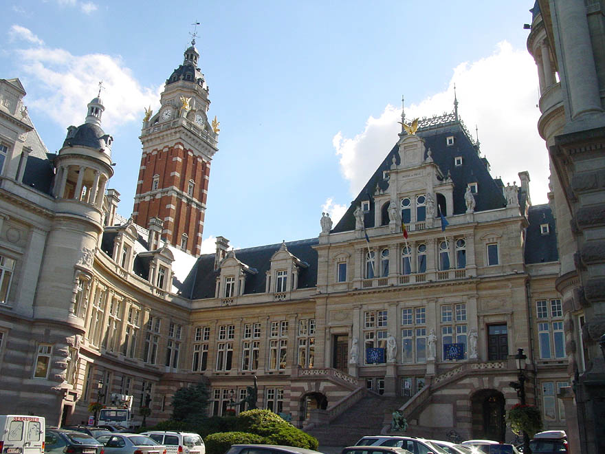
- Civic buildings: town hall, former jails and parish churches are part of the local heritage linked to the period of enlargement.
Contemporary role and importance
Today Saint-Gilles is primarily urban and residential, with a lively street life and a mix of long-term residents and newer arrivals. Its compactness and transit links make it an important node for commuters and for businesses that serve the wider city. The municipality's high density contrasts with more suburban parts of the Brussels region and contributes to its reputation as a bustling inner-urban district.
Distinctive facts and administration
As an official municipality Saint-Gilles retains its own local council and mayor within the framework of the Brussels-Capital Region. The area's bilingual character, with both French and Dutch used in public life, reflects the wider linguistic and administrative complexity of Brussels. The reconfiguration of streets and public works in the 19th century, championed by planners such as Victor Besme, remains a defining chapter in the municipality's urban history and continues to shape its identity.
For further basic information on the regional and national context, see resources about the Brussels-Capital Region and Belgium. Local guides and municipal records provide more detailed accounts of individual streets, buildings and demographic changes over time.
Questions and answers
Q: What is Saint-Gilles?
A: Saint-Gilles is a municipality in the Brussels-Capital Region of Belgium.
Q: What happened in 1830 in relation to Saint-Gilles?
A: In 1830, Brussels became the capital of newly founded Belgium, which led to the growth of the rural village of Saint-Gilles.
Q: How has the population of Saint-Gilles evolved over time?
A: The population of Saint-Gilles increased from 2,500 around 1800 to more than 33,000 in 1880, eventually reaching a peak of 60,000 in 1910.
Q: Who remodeled the pattern of the streets in Saint-Gilles?
A: The pattern of the streets in Saint-Gilles was completely remodeled by architect and urbanist Victor Besme.
Q: What were some of the buildings constructed in Saint-Gilles in the 1860s?
A: In the 1860s, buildings such as the Louise Avenue, the Brussels-South railway station, the new Saint-Gilles church, and the new jail and city hall were constructed in Saint-Gilles.
Q: Is Saint-Gilles a densely populated municipality?
A: Yes, Saint-Gilles is one of the densest municipalities in the Brussels agglomeration.
Q: What language names are used for Saint-Gilles?
A: Saint-Gilles is known as "Saint-Gilles" in French and "Sint-Gillis" in Dutch.
Related articles
Author
AlegsaOnline.com Saint-Gilles (Sint-Gillis): a Brussels municipality and urban quarter Leandro Alegsa
URL: https://en.alegsaonline.com/art/85666
Sources
- statbel.fgov.be : Population per municipality as of 1 January 2016
- monographie.org : Monographie de Saint-Gilles lez-Bruxelles - Histoire et description illustrées
- worldcat.org : 80713780
- commons.wikimedia.org : Saint-Gilles (Brussels)