
Saigon River — main waterway of Ho Chi Minh City and southern Vietnam
Principal river in southern Vietnam that flows through Ho Chi Minh City into the Mekong Delta region; important for navigation, commerce, fisheries and urban infrastructure, with tidal and flood management challenges.
Overview: The Saigon River is a principal river in southern Vietnam that passes through the metropolitan area of Ho Chi Minh City. In Vietnamese it is known as Sông Sài Gòn and is one of the important waterways of Vietnam. The river system begins in the catchment of the Dau Tieng Reservoir near the border area with Cambodia and flows generally south and south‑southeast for about 150 kilometres before entering a tidal floodplain connected to the Mekong Delta network.
Image gallery
10 Images


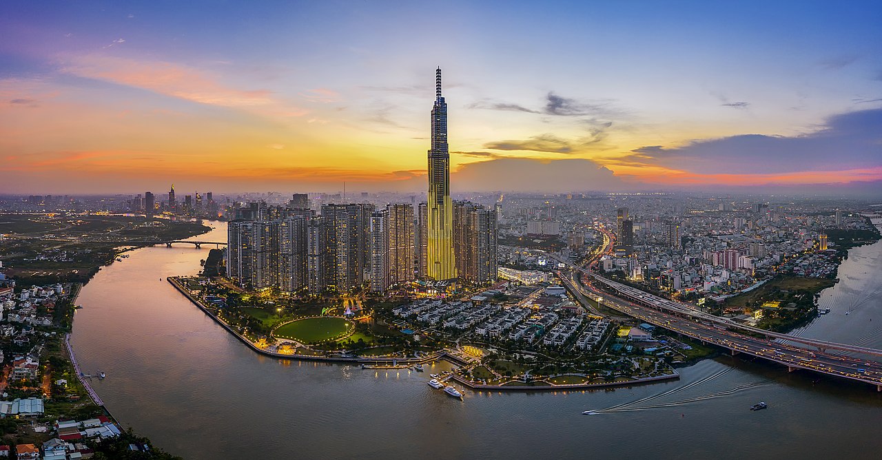


Course and characteristics
The Saigon River collects drainage from a mixed rural and urban basin. Its upper reaches are influenced by reservoir releases that moderate seasonal flow, while its lower reaches are tidal and linked to a complex of estuarine channels. The river exchanges water with adjacent waterways and irrigation canals (canal links), and it converges with other rivers in the estuary system before passing under major crossings such as the Phu My Bridge and reaching coastal waters. Flow patterns and water levels are affected by rainfall, reservoir operations and tidal cycles (flow data).
History and development
Human settlement and trade have long been oriented to the Saigon River. Small ports, landing places and markets arose on its banks; during colonial and later periods the river became a conduit for rice, rubber and manufactured goods. Over the 20th and 21st centuries the riverfront has been transformed by urban expansion in Ho Chi Minh City, with roads, port facilities and riverside development reshaping traditional waterfront communities. Redevelopment efforts seek to integrate transport, flood protection and public open space while maintaining commercial access.
Economic uses
- Transport and trade: the river supports barges, ferries and cargo vessels that move goods into and out of the region, sustaining regional commercial activity and hinterland connections.
- Port infrastructure: the Saigon River hosts major river port facilities that serve Ho Chi Minh City and surrounding provinces; wharves handle container traffic, bulk commodities and domestic freight (river port).
- Fisheries and aquaculture: local communities harvest wild fish and practice aquaculture for species including carp and catfish; shrimp (shrimp) and snails (snails) are also produced or gathered in connected waterways.
- Water supply and industry: treated river water contributes to municipal and industrial uses after appropriate processing.
- Recreation and tourism: river cruises, promenades and riverside markets provide recreational and visitor attractions along the waterfront.
Ecology and management
The Saigon River supports diverse aquatic life, but intensive urbanization, untreated wastewater, industrial discharges and sedimentation have stressed riverine ecosystems. Authorities, research institutions and community groups have implemented monitoring, pollution control and restoration measures. Stocking programs have released native species to help rebuild local populations, and conservation initiatives aim to balance livelihoods with biodiversity by protecting nursery habitats and improving water quality (native species programs).
Flooding, tides and infrastructure
The river's lower reaches lie on a low floodplain and are subject to tidal influence from the sea. High tides combined with heavy rainfall can produce urban inundation in low-lying districts of Ho Chi Minh City; stormwater and rainwater management are therefore central to municipal planning. Engineering responses include improved drainage, flood barriers, embankments and coordinated reservoir operations upstream to reduce peak flows. Maintaining navigable channels and port access while managing sedimentation is another recurring infrastructure task.
Communities and livelihoods
Riverside communities rely on the Saigon River for transport, fishing and small-scale commerce. Traditional livelihoods coexist with modern urban jobs, and there is active interest in community-based programs that combine flood mitigation, waste reduction and habitat restoration to support fisheries and water-based enterprises. Public awareness campaigns and local projects often aim to reduce pollution inputs and encourage sustainable use of river resources.
Regional context and further resources
The Saigon River basin lies within a broader hydrological and economic landscape that includes tributary systems, reservoirs and the Mekong Delta. For general information on the river and navigation, see basic river information pages (river information) and studies of river hydraulics and flow. Practical resources related to port operations, riverfront planning and transport are available through municipal portals and local agencies (port, city). Topics such as canal connectivity (canal networks), delta links (delta), commercial uses (commerce) and specific aquaculture practices (shrimp, snails) are discussed in regional reports and community notices. Readers seeking ecological or fisheries guidance may consult summaries of restocking and management initiatives (restocking).
Questions and answers
Q: What is the Saigon River?
A: The Saigon River is a river in Vietnam that flows south and south-southeast for about 150 kilometres.
Q: Where does the Saigon River begin?
A: The Saigon River begins at Lake Dau Tieng near the country of Cambodia.
Q: What is the purpose of the river system in southern Vietnam?
A: The river system in southern Vietnam helps with water transport for commercial activities and supplies water to businesses and agricultural operations.
Q: Where is the river port on the Saigon River located?
A: The river port on the Saigon River is located at Ho Chi Minh City.
Q: What rivers meet at the end of the Saigon River?
A: The Saigon River meets the Nha Be and Dong Nai rivers at its end.
Q: Why does Ho Chi Minh City regularly flood?
A: Ho Chi Minh City regularly floods due to either tidewater or rainwater.
Q: What kinds of aquatic life can be found in the Saigon River?
A: The Saigon River has many fish, and shrimp and snails are popular for farming. Recently, the government released native fish to improve the population.
Related articles
Author
AlegsaOnline.com Saigon River — main waterway of Ho Chi Minh City and southern Vietnam Leandro Alegsa
URL: https://en.alegsaonline.com/art/85296
Sources
- documents.worldbank.org : "Viet Nam - Dau Tieng Irrigation Project"
- iwapublishing.com : iwapublishing.com
- monre.gov.vn : monre.gov.vn/v35/default.aspx?tabid=675&CateID=59&ID=120623&Code=9E9Y120623