Saar (river) — course, history, and significance in France and Germany
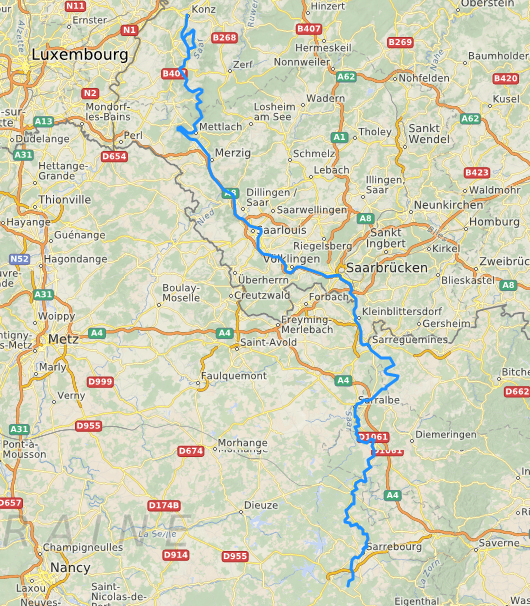
The Saar is a transboundary river rising in the Vosges (Grand Est, France) and flowing north through Saarland and Rhineland-Palatinate into the Moselle near Trier. Overview of its course, history, uses, and environment.
Overview
The Saar (French: Sarre) is a notable river in western Europe that flows from the Vosges highlands in northeastern France through parts of the German federal states of Germany, notably Saarland and Rhineland-Palatinate, before joining the Moselle near Trier. The Saar's valley links upland water sources with lower Rhine tributaries and has been an important corridor for transport, industry and settlement for centuries.
Image gallery
10 Images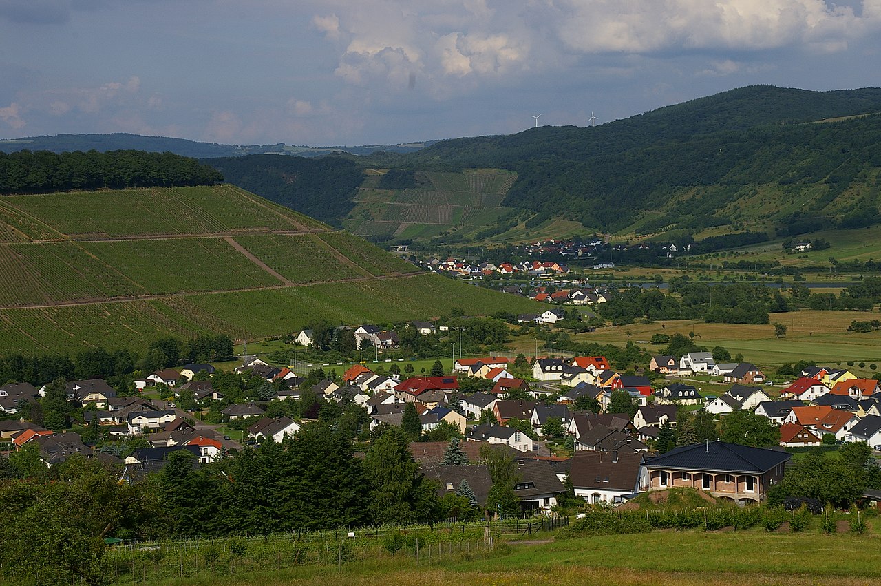


Course and characteristics
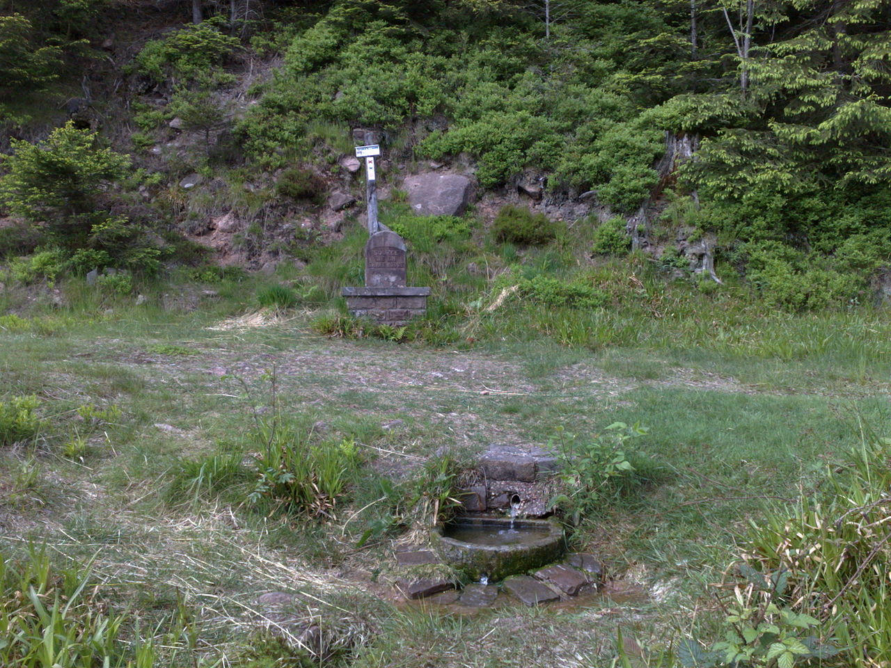
The river rises in the Vosges massif in the Grand Est region and descends generally northward, collecting a number of smaller streams and brooks along its route. Its middle and lower reaches form a broad valley with meanders, floodplains and engineered channels where waterways have been modified to support navigation and flood control. The Saar's basin includes woodland, agricultural areas and urbanized corridors centered on historic towns and industrial centers.
History and name
The Saar is recorded in classical literature; the Latin form Saravus appears in the late Roman poem Mosella by the Roman poet Decimus Magnus Ausonius. Over time the name evolved in local languages — in French as Sarre and in German as Saar — reflecting the river's position on cultural and political frontiers. Its valley has seen Celtic, Roman and medieval settlement layers and later industrial development tied to coal and steel in the 19th and 20th centuries.
Uses and economic importance
Historically the Saar valley supported mining and heavy industry because of nearby coal and iron deposits. Navigation improvements made parts of the river suitable for barges and freight, linking inland industry to the Moselle and Rhine networks. Today the river remains important for local transport, recreation and tourism: riverside trails, cycling routes and preserved industrial heritage sites draw visitors.
Ecology and management
Like many European rivers, the Saar has been managed extensively: dams, channels and flood protection coexist with restoration projects aimed at improving water quality and habitat. Efforts to reestablish fish migration routes and revive wetlands reflect broader environmental policies across regional authorities. Cross-border cooperation between French and German administrations is central to managing water resources, flood risk and conservation along the Saar.
Notable towns and features
- Upper reaches: upland springs and wooded valleys in the Grand Est region.
- Middle course: industrial towns and transport corridors, with mixed urban and rural landscapes.
- Lower reaches: approaches to the Moselle near Trier and connections to the wider Rhine network.
The Saar continues to be valued for its historical significance, regional economic role and natural environment. Information and resources about its watershed, navigation rights and conservation initiatives are available through regional agencies and cross-border partnerships (Grand Est authorities and Saarland administrations cooperate on planning). For further context on rivers and regional geography see related materials linked by administrative and cultural institutions.
Related topics: river management, transboundary river cooperation, industrial heritage and regional landscapes.
Questions and answers
Q: Where is the Saar river located?
A: The Saar river is located in northeastern France (Grand Est) and western Germany (Saarland, Rhineland-Palatinate).
Q: Which river does the Saar flow into?
A: The Saar is a right tributary of the Moselle River.
Q: Where does the Saar originate?
A: The Saar originates in the Vosges Mountains in Grand Est.
Q: In which language was the first written mention of the Saar found?
A: The first written mention of the Saar was found in the poem Mosella by the Roman poet Decimus Magnus Ausonius in Latin language as Saravus.
Q: Is the Saar a left or right tributary of the Moselle River?
A: The Saar is a right tributary of the Moselle River.
Q: In which direction does the Saar flow?
A: The Saar flows northwards into the Moselle near Trier.
Q: What is the Saar called in French?
A: The Saar is called Sarre in French.
Related articles
Author
AlegsaOnline.com Saar (river) — course, history, and significance in France and Germany Leandro Alegsa
URL: https://en.alegsaonline.com/art/85067
Sources
- wiki.dickinson.edu : Wiki text and translation of the poem Mosella
- lorraine.developpement-durable.gouv.fr : "Débits Caracteristiques en m3/s"
- lorraine.ecologie.gouv.fr : Länge in Teilstrecken
- services.sandre.eaufrance.fr : "La Sarre (A9--0100)"
- services.sandre.eaufrance.fr : "Ruisseau de Gondrexange (A9020440)"
- services.sandre.eaufrance.fr : "Ruisseau le Landbach (A9040380)"
- services.sandre.eaufrance.fr : "Ruisseau le Naubach (A9080300)"
- services.sandre.eaufrance.fr : "L'Albe (A91-0200)"
- services.sandre.eaufrance.fr : "Ruisseau la Rosselle (A95-0200)"
- services.sandre.eaufrance.fr : "Ruisseau Bruchbach (A9600440)"
- services.sandre.eaufrance.fr : "La Nied (A9--0120)"
- services.sandre.eaufrance.fr : "La Bievre (A9030300)"
- services.sandre.eaufrance.fr : "L'Isch (A90-0210)"
- services.sandre.eaufrance.fr : "Ruisseau l'Eichel (A92-0200)"
- services.sandre.eaufrance.fr : "La Blies (A93-0200)"