Ruhr
![]()
This article is about the Ruhr metropolitan region; for the corresponding regional association, see Regionalverband Ruhr.
With around 5.1 million inhabitants and an area of 4,438.69 square kilometres, the Ruhr region is Germany's largest conurbation and the fourth largest in Europe. The name of this densely populated central region of North Rhine-Westphalia is derived from the Ruhr River, which runs along its southern edge. Together with its surrounding area, which is also densely populated, and the conurbations along the Rhine, which extend far into the Cologne Bay, it forms the Rhine-Ruhr metropolitan region, in which around ten million people live in an area of around 7000 square kilometres. It is the central part of the European mega-region "Blue Banana". Plans to form a Ruhr metropolis are often subsumed under the term Ruhrstadt. In 2010, the Ruhr region was European Capital of Culture under the short designation RUHR.2010 (along with Pécs/Hungary and Istanbul).
The Ruhr area historically belongs to Westphalia and the Rhineland and is essentially formed by several large cities that have grown together. From the settlements on the central Lower Rhine, the urban landscape merges seamlessly to the east into the Rhine-Ruhr region and to the south into the Rhine region. Four of the five major centres and core cities of the Ruhr area (Duisburg, Essen, Bochum and Dortmund) were already established in the Middle Ages along the Westphalian Hellweg and reached their present structure with industrialisation and mining in the 19th and 20th centuries. The fifth regional centre (Hagen) was not established until the 18th century.
The term Ruhr region is usually based on the boundaries of the Ruhr Coal District Settlement Association, founded in 1920 and now the Ruhr Regional Association (RVR). The RVR includes the independent cities of Bochum, Bottrop, Dortmund, Duisburg, Essen, Gelsenkirchen, Hagen, Hamm, Herne, Mülheim an der Ruhr and Oberhausen as well as the districts of Recklinghausen, Unna, Wesel and the Ennepe-Ruhr district, which belong to the Rhineland and Westphalia. The data in the following refer to the administrative area of the RVR. A separate administrative district for the Ruhr conurbation does not yet exist; it is divided between the three districts of Arnsberg, Düsseldorf and Münster.
Geography

enlarge and show information about the picture
![]()
Panorama of the western Ruhr area (with markings)
In 2012, the Regionalverband Ruhr determined the spatial extent and boundaries of the Ruhr region. In this context, the centre of the Ruhr area was determined by calculation between the westernmost and easternmost as well as the northernmost and southernmost points. The point of intersection and thus the midpoint of the "Metropole Ruhr" is located in the Herne district of Röhlinghausen at Rolandstr. 49 in 51° 31′ 3″ N, 7° 8′ 42″ E51.51757.145. At this point, a granite stone with the inscription "You are at the geographical midpoint of the Ruhr region in Herne-Röhlinghausen" was erected at the edge of the sidewalk.
Nature area
The Ruhr area has a share in several natural units. The urban landscape lies at the intersection of the Westphalian Lowland Plain, the Lower Rhine Plain and the Rhenish Slate Mountains. To the north of the Lippe, the natural units of the Westmünsterland and the Kernmünsterland adjoin. South of the Ruhr it extends into the Bergisches and Märkisches Hügelland. To the north of the Ruhr, the loess plains of the Westenhellweg natural area adjoin. Between the Lippe and the Westenhellweg lies the Emscherland. The Emscher separates the Westphalian Bay from the Rhenish Slate Mountains. Corner points are Wesel (district Wesel) in the northwest, Duisburg in the southwest, Hagen in the southeast and Hamm in the northeast. The west-east extension from Sonsbeck to Hamm is 116 kilometres, the north-south extension from Haltern am See to Breckerfeld is 67 kilometres.
According to data from the Ruhr Regional Association (RVR), 37.6 per cent of the area of the Ruhr region is built on. 40.7 percent of the area is used for agriculture. The share of forest is 17.6 percent. The remaining share is accounted for by water areas and other land. The relatively high proportion of forest and agricultural land for an industrial region is initially explained by the four predominantly rural districts which also belong to the RVR. In addition, the outlying districts of the independent cities of the Ruhr Area also have a rural character. This includes the Siepental landscape, which the incorporation treaties concluded at the beginning of the 20th century had already classified as "valley hollows" worthy of protection. The Ruhr Coal District Settlement Association also aimed to prevent the individual towns from growing together and urban sprawl. To this end, from 1923 onwards it bought up plots of land, kept them free of buildings of any kind and defined them as regional green corridors. Their north-south course has been preserved to this day between the cities in the Ruhr conurbation despite fundamental conflicts of objectives.
Urbanization
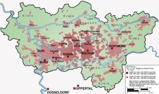
Viewed on a map, the Ruhr area could be considered a single large city, as there are no discernible boundaries between the individual cities, at least in the west-east expansion. Thus, the Ruhr area can be described as a polycentric urban landscape. In this context, one also speaks of the Ruhr city or "Metropole Ruhr". The area is characterised by its similar urban and economic geographic development.
Due to its history, the Ruhr area is structured differently than monocentric agglomerations such as Paris, which were created by the rapid merging of smaller towns and cities with a core city. The individual cities and districts of the Ruhr Area grew independently of each other during industrialisation. The population density of the Ruhr core zone is just under 2,280 inhabitants per square kilometre.
| Population, area and population density in the Ruhr region (31.12.2019) | |||
| City/county | Inhabitants | Area | Population density Inhabitants per km² |
| County boroughs | |||
| Bochum | 365.587 | 145,66 | 2.509 |
| Bottrop | 117.565 | 100,61 | 1.168 |
| Dortmund | 588.250 | 280,71 | 2.096 |
| Duisburg | 498.686 | 232,8 | 2.142 |
| Food | 582.760 | 210,34 | 2.770 |
| Gelsenkirchen | 259.645 | 104,94 | 2.474 |
| Hagen | 188.686 | 160,45 | 1.176 |
| Hamm | 179.916 | 226,43 | 795 |
| Herne | 156.449 | 51,42 | 3.043 |
| Mülheim an der Ruhr | 170.632 | 91,28 | 1.869 |
| Oberhausen | 210.764 | 77,09 | 2.734 |
| Circles | |||
| Ennepe-Ruhr district | 324.106 | 409,64 | 791 |
| Recklinghausen district | 614.137 | 761,31 | 807 |
| Unna district | 394.891 | 543,21 | 727 |
| Wesel district | 459.976 | 1.042,8 | 441 |
| District-free cities (total) | 3.318.940 | 1681,73 | 2.071 |
| Counties (total) | 1.793.110 | 2756,96 | 650 |
| Ruhr area (total) | 5.112.050 | 4.438,69 | 1.152 |
The transitions between the cities are characterised by loose suburban development, undeveloped areas and sometimes even agricultural land. In the core zone of the Ruhr area, the city boundaries sometimes run right through densely built-up outer districts and are difficult to recognise. Often, the change of urban area cannot even be seen by a change of street names, as streets in peripheral locations may cross the city boundaries several times and, in order to avoid confusion, are named and numbered throughout.
The development of the Ruhr region from an original natural area to a location of the coal and steel industry and the rapid settlement during industrialization is a frequently chosen research topic in anthropogeography. For example, the settlement history of the Ruhr area is currently being studied in relation to the classical system of central places.
In the course of recultivating industrial wastelands, new park landscapes and local recreation areas are created, such as the Hoheward Landscape Park in the northern Ruhr area. Along the only partially renaturalised Emscher river, the Emscher Landscape Park, which connects the regional green corridors created by the SVR in a north-south direction, forms a green belt running in an east-west direction between the cities. The numerous gardens and parks in the region are integrated into the European Garden Heritage Network.

Map of the settlement structure of the Ruhr area
.jpg)
Centre of the "Metropole Ruhr" at Rolandstraße 49 in Röhlinghausen
Geology
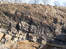
Geologically, the Ruhr area is regularly defined by the occurrence of Upper Carboniferous coal-bearing strata, more or less independent of their depth. The coal seams graze the surface along the Ruhr and sink to the north. At the level of the river Lippe they lie at a depth of 600 to 800 metres. The average thickness of the strata is 1-3 metres. The geology of the underground was decisive for the development of coal mining in the Ruhr area. It is related to the formation of the supercontinent Pangaea. At the beginning of the Variscan mountain building 400 to 300 million years ago in the Devonian and Carboniferous periods (the name means coal age), ore solutions began to rise along tectonic fault lines in the course of mountain building and some ore deposits were formed.
Simultaneously with the rise of the Rhenish Slate Mountains in the Upper Carboniferous, a subsidence of the northern foreland began, into which sediments were periodically poured. Over millions of years, the depositional environment alternated between a shallow sea, the formation of river deltas and sedimentation by eroded sediments from the new mountains. In the warm and humid climate of that time, large bogs could form, which were often covered by thick sandy sediments, causing the carbonization of the plant material. Thus hundreds of coal-bearing layers were formed in the subsoil. Of these, however, only those 70-80 seams that reach a sufficient thickness were and are worth mining. The large-scale subsidence caused that today at Witten (southern edge of the Ruhr area) the coal reaches up to the earth's surface, but at the northern edge (for example at Marl) it lies about 1500 metres deep.
Coal mining and drainage
For decades the coal mining industry drove the economy in the Ruhr area. There were collieries in many places in the Ruhr area, all of which have now closed. However, Ruhr mining has also caused considerable damage, including subsidence. In some places the ground is now lower than the surrounding waters. Therefore the Ruhr area cannot do without a large number of pumping stations. If the pumping stations were to be shut down, the Ruhr area would turn into a lake district, according to the Westdeutsche Allgemeine Zeitung and Der Westen. Also in a report of the Deutsche Welle it was stated that mine water and groundwater rise would be a threat for the Ruhr area. Not only is the Ruhr area in danger of being flooded by groundwater after major subsidence, but also mine water polluted by minerals has to be cleaned constantly to prevent it from penetrating into the groundwater strata that serve as drinking water supply. Constant pumping, so that no land goes under, costs about 220 million euros a year, paid for by the RAG foundation. It is still unclear who will pay in the long run for these burdens of eternity if the mining companies were to withdraw.

Low thickness coal seams (Namur C, Upper Carboniferous) in a quarry at Wetter (Ruhr)
Search within the encyclopedia