→ Main article: History of Rostock
Name
The name Rostock can be traced back to the 11th century: to rastokŭ, a Slavic (Old Polish) term meaning something like "flowing apart" in reference to the Warnow River. From the 12th to the early 14th century, variants of Rozstoc appear via Rostoch, Rotstoc, Rotstoch, Rozstoc, Roztoc and Rostok - and finally Rostock around 1366. Additions to the name have been known since the 1920s: until 1945 Seestadt, from 1990 Hansestadt and since 2018 Hanseatic and University City of Rostock.
Medieval
Emergence of the city
Archaeological finds document Slavic craftsmen and trading places on the right bank of the Warnow (between today's Dierkow and Gehlsdorf) from the 8th century onwards. At the latest in the 12th century there was a Kessin princely castle with an early urban market settlement. The chronicle Gesta Danorum (around 1200) is considered to be the first reliable record of Rostock. In it, the Dane Saxo Grammaticus reports on the destruction of the Slavic princely castle in 1161 by King Waldemar I and the subjugation of Prince Pribislaw and his enfeoffment by the Saxon Duke Henry the Lion in 1167. Among the new castles of the new vassal was also the Urbs Rozstoc, which gradually developed into a second focal point of the land of Mecklenburg next to the nearby castle of Kessin.
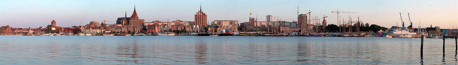
The starting point of Rostock's development as a city was the settlement on the higher left bank of the Warnow. Craftsmen and merchants settled here in the 12th century, and Prince Nicholas I granted the monks of the Doberan Monastery duty-free access to the Rostock market in 1189. This is also the first documentary mention of Rostock. The first documentary mention of the city of Rostock dates back to June 24, 1218, when Heinrich Borwin I confirmed the Lübische town charter. Soon the city expanded from the Petrikirche to the south and received another parish with the quarter around the Nikolaikirche. New settlements were established in the west with St. Mary's Church as the parish church and its own market, as well as a new town even further west, the centre of which was St. Jacob's Church. From 1262 to 1265 the three settlements were united. The middle settlement core became the administrative centre of the town with a town council, a court and a new town hall. A ring-shaped city wall was built for protection. The Stone Gate, the Kröpelin Gate, the Monk's Gate and the Cow Gate are still preserved today.
Even the city fires of 1250 and 1265 could not stop Rostock's rapid rise to become the most important city in Mecklenburg. The centre of the Rostock dominion was strengthened by trade privileges and rights such as fishing rights on the Lower Warnow. In 1252 the city forest Rostocker Heide could be acquired, in 1264 the seaport near Warnemünde (Hohe Düne), in 1278 the Hundsburg near Schmarl and in 1286 the Wendish Wyk on the right side of the Warnow. This ensured, among other things, the desired free access to the Baltic Sea twelve kilometres away.
Hanseatic City
As early as 1259, Rostock had formed an alliance with the councillors of the cities of Lübeck, Stralsund, Wismar and Kiel. The Wendish League of Cities is considered the nucleus of the German Hanseatic League; it was strengthened by further cities in 1283 in the treaty known as the Rostock Land Peace. Until the last Hansa Convention in 1669, Rostock took a leading role - in competition with Stralsund for the role of the most important city in the Baltic Sea behind Lübeck. Significant for this were merchants who maintained trade relations with the cities of Riga (Rigafahrer) and Visby on the island of Gotland, as well as the herring trade of the Schonenfahrer at the Schonische Messe. With regard to trade with Norway, the Rostock Wiekfahrer concentrated on controlling the factories in Oslo and Tønsberg on the Oslo Fjord. The only product of Rostock's own that it exported to any significant extent was beer.
Flourishing and university
When the territorial rule of Rostock ended in 1323, the city council had already survived several uprisings of the craftsmen and citizens. The 14th century is generally regarded as a time when the city flourished: in 1323 the fishing village of Warnemünde was acquired outright, in 1325 the city received the right to mint coins, and in 1358 full jurisdiction. The buildings begun in the 13th century, especially the four parish churches (see above) and some monasteries, were completed, the town hall was architecturally enhanced by new corner towers, pointed-arched blinds and circular rosettes. The Hanseatic city had reached the peak of its autonomy. With about 14,000 inhabitants, it was one of the largest cities in northern Germany around 1410.
Another visible sign of Rostock's importance was the oldest university in northern Europe, founded in 1419. Both the sovereigns and the city council pursued the goal of consolidating their respective positions of power with the foundation. Despite several exits due to political turmoil, Rostock was to play a leading role in science for two centuries through its university.
→ Main article: University of Rostock
early modern period
The Reformation in Rostock started from St. Peter's Church, where Joachim Slüter had served as chaplain since 1523. Surprisingly, the council gave up its resistance in April 1531 and declared Martin Luther's teachings binding in all four main parish churches. The university as well as the monasteries of the Holy Cross, St. Johannis and the Charterhouse in Marienehe, however, remained faithful to the old teachings.
In June 1549 Johann Albrecht I enforced the Lutheran confession for all estates and dissolved almost all Mecklenburg monasteries in 1552. In Rostock, the nunnery of the Holy Cross resisted the Reformation for a long time until it was converted into a convent for the upper classes of the city. The Charterhouse of Marienehe was forcibly abolished in 1552.
In 1523 the estates joined together and confronted the sovereigns with self-confidence. During the feud of the counts in 1534, there were again riots and the city council had to recognize a citizens' council composed of 64 merchants and craftsmen. When the war ended in 1535 with a defeat by Denmark, the old conditions were restored without any significant opposition, but in future the council was to face citizens' committees in all disputed cases. In 1562 to 1565 a council of sixty was placed on an equal footing with the town council, and again defied it for a citizens' charter. After the city had refused him the formal oath of homage, Johann Albrecht I, who was allied with the council, entered Rostock with armed forces, dissolved the sixties and destroyed the citizens' charter. At the beginning of 1566 the stone gate and the southern city wall were torn down and a fortress was built in front of the city. It was not until the Rostock inheritance treaties of 1573 (First Rostock Inheritance Treaty) and 1584 that the smouldering conflict between the city and the sovereign was settled. Rostock acknowledged the sovereignty of the duke, especially with regard to jurisdiction and the payment of taxes. Rostock's efforts to achieve imperial immediacy had thus finally failed, but the Stone Gate could be rebuilt and the ducal fortress could be razed. In 1583/84, in addition to the council, which continued to be made up of patricians capable of holding office, a new citizens' committee was set up, the Hundertmänner-Kollegium, which was made up of 40 brewers, 20 other merchants and 40 craftsmen. After several centuries of unrest, this was the first time that the city had achieved long-term internal peace. In contrast to earlier citizens' committees, the sovereigns were hardly able to play the council and the college off against each other, even though the cooperation between the two bodies was not always free of tension.
Around 14,000 inhabitants, a good 800 gabled houses and about 250 to 300 breweries were an expression of prosperity at the end of the 16th century. The economy was completely determined by maritime trade and brewing.
The Thirty Years' War (1618-1648) irrevocably brought about the end of the Hanseatic League. At first Mecklenburg was hardly affected by the war, but with the entry of Denmark into the war, the war spread to northern Germany and the hostilities reached Mecklenburg in 1627. Wallenstein occupied the town with an army of 1000 men and turned it into a garrison town. In Warnemünde a redoubt was built to be able to hold the harbour. In 1631 the imperial occupation of Rostock ended and the "Swedish period" began. This change of power had no major consequences for Rostock, for example the university flourished despite the turbulent times. While the countryside and the villages of Mecklenburg were defenceless against the violence and plundering of the soldiery, the city walls of Rostock offered protection to many refugees. Rostock's maritime trade, however, declined drastically. The city was hit hardest by a customs duty granted to the Swedes by the dukes of Mecklenburg off Warnemünde.
In a phase of stagnation after the Thirty Years' War, the devastating town fire of 1677 occurred. Almost the entire old town and a considerable part of the northern middle town fell victim to the flames. In total, a third of all the buildings in the town were destroyed - about 700 houses and stalls. It weighed particularly heavily that the centre of Rostock's brewing industry in the streets leading to the harbour had been destroyed. The number of breweries fell from almost 200 to less than 100, the population, which had been 14,000 at the end of the 16th century, dropped to 5,000.
The Great Northern War of 1700 to 1721 brought a further deterioration of trade links and led to looting by Danish and Swedish troops.
The Seven Years' War also marked the city, which was occupied by Brandenburg from 1758 to 1762. In addition, the absolutist princes took advantage of Rostock's weakness and secured their power in the long term during this period with the Landesherrlichen Erbverträgen of 1755 and 1788. Since 1702, Rostock had temporarily become the residence of the dukes and had finally become a Mecklenburg country town. In the 18th century, the university sank into insignificance and also had to compete with a ducal university in neighbouring Bützow, which existed from 1760 to 1789. It was not until the end of the 18th century that Rostock slowly began to rise again.
enlarge and show information about the picture
Vicke Schorler: True Abcontrafactur of the highly praiseworthy and widely famous old sea and hens city Rostock - capital in the country of Meckelnburgk (1578-1586)
19th century
The Mecklenburg bourgeois-liberal opposition of the March Revolution against the Estates State, which was politically dominated by aristocratic landowners, gathered around the Rostock editorial office of the Mecklenburgische Blätter and the Rostock Zeitung in 1847/48. In November 1848 the moderate workers' association was also founded. The old council system was reformed in 1848. After 30 months, however, the Grand Duke of Mecklenburg-Schwerin reinstated the old body of one hundred men.
Rostock's maritime trade grew steadily in the 19th century and remained the city's economic driving force. In the mid-19th century Rostock had the largest merchant fleet in the Baltic region, most of whose ships were built in local shipyards. Rostock was connected to the German railway network in 1850.
Due to the North German law on freedom of movement of November 1, 1867, freedom of settlement became effective in the entire federal territory in January 1868, so that Rostock's ban on Jews seeking to settle and earn a living in the city, which had been maintained since 1350, was also dropped. It was not until the second half of the 19th century that the city brought new wealth with the freedom of trade and comprehensive industrialisation. In 1890 the Actien-Gesellschaft "Neptun" Schiffswerft und Maschinenfabrik in Rostock, today's Neptun-Werft, was founded as the first large industrial enterprise in Mecklenburg. Other growing economic branches were the chemical industry, agricultural machinery construction as well as the building industry and service companies. Warnemünde developed into one of the most important seaside resorts in Germany in the first decades of the 19th century. With the founding of the German Empire in 1871, the dynamic development process of the Gründerzeit also began in Rostock, although Rostock lagged behind most German cities of comparable size in its development.
Since 1830 Rostock began to grow beyond the area of the medieval city wall boundaries for the first time. Many city gates were demolished in the course of the defortification of the city in the 19th century. The Zwinger, which stood as a fortified tower in front of the Steintor, was also blown up by Prussian pioneers in 1849.
On 10 August, Wilhelm II visited the regiment bearing his name, Grand Ducal Mecklenburg Fusilier Regiment "Kaiser Wilhelm" No. 90, on the occasion of its 125th birthday, as well as the town hall, St. Mary's Church and the university.
First to Second World War
The hardship of the First World War resulted in unrest and strikes by the civilian population. Three days after the Kiel sailors' revolt, 1500 sailors, infantrymen and Landsturmleute formed a soldiers' council on 6 November 1918. Workers at the Neptune shipyard, the Dolberg munitions factory and other factories declared their solidarity and formed a workers' council one day later.
After the economic crisis during the Weimar Republic, aircraft construction in particular was able to provide new impetus in Warnemünde with the two companies Heinkel and Arado founded in the early 1920s. The most important industrial enterprise remained the Neptun shipyard.
With the Gleichschaltung of the Länder, all KPD mandates were abolished and the city council was reconstituted on the basis of the Reichstag elections of March 1933, which were no longer considered free elections and in which the NSDAP had become the strongest party in Rostock with 35.5 %. Since some bourgeois parties boycotted the election staging over the filling of the assigned mandates and the DVP and the Christian Social People's Service transferred their mandates to the NSDAP, the new city council was composed of 15 deputies of the NSDAP, 12 of the SPD and 8 of the Kampffront Schwarz-Weiß-Rot. Immediately after the Enabling Act of 24 March 1933 and the nationwide ban on the SPD on 22 June 1933, the city council consisted exclusively of National Socialists. On the basis of the Law for the Restoration of the Professional Civil Service, 31 offices were filled with "politically reliable" persons; sympathizers of the SPD or KPD were removed from office. Since the NSDAP lacked suitable administrative experts, the conservative Lord Mayor Robert Grabow (DNVP) could not be replaced at first, until Walter Volgmann (NSDAP) took over his office in April 1935. At the same time, the German Municipal Code made the city council.
The start of the boycott of Jews took place in Rostock as early as 30 March 1933 with the posting of SA men in front of Jewish shops and continued the following day with a large rally on the Reiferbahn. From 1938 to the middle of 1939, the ousting of Jewish businesses was completed. Within the framework of the Polish Action, a total of 37 Jews were deported to Poland on October 28, 1938. During the November pogrom of 1938 the synagogue burned down. 64 Jews arrested by the Gestapo were sent to the Altstrelitz penitentiary under difficult prison conditions. Of the 70 Jews still living in Rostock at the beginning of the war, only 14 survived. Most were deported to concentration camps in 1942/43 and murdered there. Some of the victims are commemorated today by memorial stones embedded in the ground (see also: List of memorial stones and Stolpersteine in Rostock).
The armament of the Wehrmacht brought Rostock a significant economic upswing. In 1935 Rostock had 100,000 inhabitants for the first time.
During the Second World War, the armaments factories used the local population, foreign forced labourers and prisoners of war, as well as prisoners from the Ravensbrück concentration camp.
As the centre of the armaments industry of the Third Reich, Rostock was the target of air raids by the Royal Air Force from June 1940. Particularly heavy area bombing raids hit the city on 23/24 and 26/27 April 1942 ("Viertagebombardement"), targeting the armaments factories and the city centre. Air raids followed in May and October 1942, in April 1943 and April 1944. At the end of the war, 2611 of the 10,535 residential buildings had been completely destroyed, and a further 6735 damaged.
On 1 May 1945 Rostock was occupied almost without a fight by the Red Army, which moved in via the Petribrücke. The mayor with his family and the mayor took their own lives. There was looting, theft and rape.
1945 until 1990
In August 1945, typhoid and diphtheria broke out in the city, in November also typhus. At the end of the war, only 69,000 people remained in Rostock. By 1950, the number of inhabitants had risen again to pre-war levels due to people returning from the war and displaced persons.
Not only large companies were subject to dismantling by the occupying power, but also numerous medium-sized enterprises.
In the first free election in the Soviet occupation zone, the municipal election on 15 September 1946, the SED received 48.87%, the LDPD 27.7%, the CDU 20.5% and the Women's Committee 1.98% of the votes. The mayor Albert Schulz, (SED, before SPD), who criticized the forced unification of SPD and KPD to the SED resigned in summer 1949 and fled. Ideological and economic repressions such as the Aktion Rose, which particularly affected Warnemünde, as well as the mass flight to the West led to discontent, which also resulted in strikes and demonstrations by workers in Rostock on 17 June 1953.
In 1952, Rostock had become a district city as a result of the administrative reform. The city was systematically upgraded, for example with the Baltic Sea Week, which was held from 1955 onwards and became the GDR's most important major event with an international accent after the Leipzig Fair. In the following years, the city developed into the shipbuilding and shipping centre of the GDR. In addition to the shipyards, the Dieselmotorenwerk (DMR) was built in 1949, the later Fischkombinat in 1950 and the Deutsche Seereederei Rostock (DSR) in 1952. Between 1957 and 1960, the Rostock overseas port was built.
In 1949, the reconstruction of the very badly damaged city centre between Marienkirche and Grubenstraße began. In 1948, the western city wall between Kröpeliner Tor and Fischerbastion had been demolished. From 1953 onwards, the first reconstruction projects were realised in the form of Langer Straße in the city centre and a new development area in Reutershagen in the style of socialist classicism. In 1960, the war-damaged Jakobikirche, the damaged Petritor with parts of the eastern city wall and the partially destroyed Rostock City Theatre (1895-1942) at the Steintor were demolished.
By 1988, the city had grown to over 250,000 inhabitants. From the mid-1960s onwards, new districts were built in industrial prefabricated slab construction with a total of 54,000 apartments, in which more than half of all Rostock residents then lived. Many old buildings in the inner city, on the other hand, were left to decay. The northern part of the old town, where the war damage had only been poorly repaired, was almost completely demolished in the early 1980s and replaced by prefabricated buildings a few years later.
From 1989/90
During the time of upheaval in 1989, Rostock's churches were focal points for opposition forces, who gathered in St. Mary's Church for memorial services led by Pastor Joachim Gauck. The first Thursday demonstration took place on 19 October. At the end of November, a round table was formed in Rostock to actively shape the political upheaval.
After the German reunification in 1990, the city had to struggle with enormous economic problems and experienced a strong population decline of about 50,000 inhabitants, which only came to a halt after 2000. The xenophobic riots of Lichtenhagen in August 1992, in which several hundred partly extremist rioters and up to 3,000 applauding spectators took part, must be seen as a low point of this period and are considered the most massively racially motivated attacks in German post-war history.
Rostock hosted the International Garden Show (IGA) in 2003 and has since maintained a congress and exhibition hall on the site. A joint bid with Leipzig to host the 2012 Summer Olympics failed in the international pre-selection by the IOC in 2004. In June, the 2007 Heiligendamm G8 Summit was held in the seaside resort of Heiligendamm to the west. In September 2012, the Darwineum, an evolutionary exhibition, opened at Rostock Zoo. In 2018, the city celebrated the double anniversary of 800 years of Rostock and 600 years of the university. To mark this anniversary, Deutsche Post AG issued a special stamp with a face value of 70 euro cents.
Population development
→ Main article: Rostock demography
Since Rostock did not grow beyond its borders for a long time, the population remained constant from the Middle Ages until the 19th century at a maximum of 11,000 to 14,000 people. It was only with industrialisation that this began to grow rapidly and in 1935 exceeded 100,000, making Rostock a major city. By 1940, the population had risen to 129,500. Due to the Second World War, this had fallen by about half to 68,928 by May 1945, but then rose rapidly with the immigration of German expellees from the eastern provinces.
In 1971, the number of 200,000 inhabitants was exceeded. In 1988, the city's population peaked at around 254,000. After the fall of communism in the GDR, the city lost 22 percent of its inhabitants, 55,000, due to high unemployment, the departure of many inhabitants to the surrounding areas and a decline in the birth rate. In 2007, Rostock's population rose again to over 200,000 people, with 200,413 people living in the city at the end of the year. By mid-2012, the population had risen to 204,320 people with their main residence in Rostock. In the course of the population growth, the importance of the real estate market and in particular the housing market in Rostock and its regiopolitan region is also increasing; rental and property prices are constantly rising in attractive residential locations such as urban perimeter block districts and villa colonies. In addition, new housing estates are being built in many parts of the city.