The Baja California Peninsula is a slender, roughly 1,200-kilometre landform that extends southeast from the U.S.–Mexico border and separates the Pacific Ocean on the west from the Gulf of California (Sea of Cortez) on the east. Politically it contains two Mexican states: Baja California in the north and Baja California Sur in the south. The peninsula is geographically diverse, ranging from desert lowlands and coastal plains to rugged mountain ranges and volcanic features. Its long, linear shape and position between two very different marine environments give rise to striking contrasts in climate, ecology and human use along each coast.
Geography and geologic setting
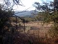
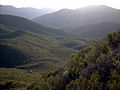
Physically the peninsula is narrow—generally 80–220 kilometres across—and dominated by the Peninsular Ranges, a chain of mountains that run along much of its length. To the east the Gulf of California is a deep, tectonic sea formed by long-term rifting and transform fault activity; to the west the continental slope drops toward the Pacific. The region is tectonically active: the opening of the Gulf and motion along related faults continue to shape the landscape, producing earthquakes and a legacy of volcanic landforms. One example of volcanic activity in the past is a caldera complex formed during eruptions hundreds of thousands of years ago.
Climate and marine influences
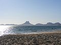
Climatic conditions on Baja California vary with latitude, elevation and exposure to the two adjacent bodies of water. The Pacific coast is influenced by the cold California Current and frequent coastal fog, locally known as camanchaca, which moderates summer heat and provides moisture in otherwise arid areas. The Gulf of California has warmer, more sheltered waters and a more pronounced tidal regime in its northern reaches where the sea is shallow. These different oceanographic regimes support distinct marine communities: the Pacific coast is known for nutrient-rich upwelling that supports whales and productive fisheries, while the Gulf hosts exceptionally high biodiversity and many islands that serve as important breeding grounds for seabirds and marine mammals.
Flora, fauna and islands
The peninsula is part of the Sonoran Desert region and contains a high proportion of endemic plants and animals adapted to arid conditions and island environments. Vegetation ranges from coastal scrub and chaparral to cactus-dominated deserts; iconic plants include massive cardón cacti, ocotillo and the unusual boojum tree. Wildlife includes a variety of reptiles, small mammals and birds, many of which are restricted to the peninsula or to its offshore islands. The Gulf of California supports dense marine life: porpoises, dolphins, seals and migratory whales frequent its waters, and seabird colonies occupy many islands. Several island groups and coastal areas have been recognized for their conservation value because of these unique assemblages.
Human history, settlement and economy
Indigenous peoples have inhabited the peninsula for thousands of years, adapting their subsistence to coastal and desert conditions. European contact from the 16th century brought exploration, missionary activity and later settlement patterns that reshaped the region. Today the peninsula combines traditional fishing and ranching with modern industries: commercial and artisanal fisheries, tourism (notably in resort towns such as Cabo San Lucas and La Paz), salt production in the northern gulf, and growing services linked to cross-border trade in the north. A major north–south highway completed in the 1970s established continuous road access from the U.S. boundary to the southern tip, which has been a key factor in expanding tourism and commerce.
Conservation and contemporary issues
Despite its natural wealth, Baja California faces environmental challenges. Freshwater is scarce across much of the peninsula; coastal and island ecosystems are sensitive to overfishing, invasive species and development pressure from tourism and expanding towns. Conservation efforts include protected areas, marine reserves and international recognition of some Gulf islands, but managing tourism growth, securing sustainable fisheries and maintaining clean water supplies remain ongoing priorities. Scientific study and local stewardship continue to play important roles in balancing economic uses with protection of the peninsula's distinctive landscapes and biodiversity.
Notable distinctions
- It is one of the longest peninsulas in the world and separates two very different marine systems.
- The peninsula harbors a high rate of endemism among plants and reptiles, and many offshore islands are important seabird breeding sites.
- Its geology records active rifting and transform faulting associated with the opening of the Gulf of California.
- Coastal fog on the Pacific side, driven by cold ocean currents, creates microclimates that sustain vegetation in otherwise arid terrain.
Overall, the Baja California Peninsula is a region of striking contrasts—between sea and land, north and south, desert and mountain—that supports a unique mix of natural communities and human activities. Its combination of scientific interest, cultural history and economic opportunity makes it a prominent feature of northwestern Mexico and an object of ongoing conservation focus.