Rio Grande (Río Bravo): Geography, History, and Environmental Issues
Overview of the Rio Grande (Río Bravo): its course from Colorado to the Gulf, role as an international border, historical importance, uses, and contemporary environmental and management challenges.
Overview
The Río Grande, called the Rio Grande in English and often the Río Bravo or Río Bravo del Norte in Spanish, is one of North America's major rivers. It flows from highlands in the interior of the continent toward the Gulf of Mexico and serves both as a natural watercourse and, for much of its lower reach, as an international boundary between the United States and Mexico. The name "Río Grande" literally means "great river" in Spanish.
Image gallery
10 Images


Course and geography
The river's headwaters arise in the San Juan Mountains of Colorado. From there it flows south through New Mexico, where it traverses high desert and valley landscapes and passes several urban centers. Continuing southeast it enters Texas, where a long stretch of the river forms the international border with Mexico. Along the border the river runs adjacent to the Mexican states of Chihuahua, Coahuila, Nuevo León, and Tamaulipas, before finally reaching the Gulf of Mexico.
Characteristics and uses
The Rio Grande passes through diverse climates and elevations: alpine headwaters give way to arid basins and irrigated agricultural valleys. Its waters are used for municipal supply, irrigation, limited hydropower generation, and recreation such as boating and fishing. Large urban areas and agricultural regions depend on its flow, and numerous dams and diversion works regulate water for human uses.
History and political role
The river has long been important to Indigenous peoples, Spanish and Mexican settlers, and later to communities on both sides of the modern border. Since the 19th century the Rio Grande has had political significance as a boundary; treaties and bilateral agreements now govern allocation, flood control and infrastructure. Because rivers naturally change course, its shifting channels have occasionally complicated border definitions and land ownership.
Environmental challenges
The Rio Grande faces several environmental pressures: periodic drought and variability in precipitation reduce flows, while agricultural and urban demands often strain supplies. Water quality concerns include salinity, agricultural runoff and wastewater discharges. Habitat loss has affected native fish and riparian vegetation. In response, regional agencies, binational commissions and local stakeholders work to manage allocation, restore habitat and balance human and ecological needs.
Notable facts and distinctions
- The river is known by two prominent names—"Rio Grande" in the U.S. and "Río Bravo" in Mexico—reflecting different cultural and historical traditions.
- Its upper course flows through high mountains and plateaus, while its lower course serves as an international border.
- Management of the river requires cooperation across state and national boundaries and involves multiple jurisdictions and treaties.
For further reading on regional geography, water law and conservation efforts, consult governmental and academic resources that specialize in transboundary river management and the ecology of the U.S.–Mexico borderlands.

The names of the river
The river already had a variety of names: Rio Grande, meaning Great River, it was also called in translation in the languages of various Indian tribes, among whom it bore the names Mets'ichi Chena, P'osoge, and Paslápane. The Comanches called the river ocuebi.
The Spaniards who arrived in the 16th century first called the river Río de las Palmas; because they got to know it from its mouth, where there were extensive beaches with light sand and a multitude of palm trees. Among the Spaniards alone, who "rediscovered" it in various places in the early days, and did not know at that time that it was always the same river, the Río de las Palmas, it bore a variety of names:
- Río Caudaloso (Watery River)
- Río de la Nuestra Señora (River of Our Patroness)
- Río Turbio (Turbid River)
- Río Guadalquivir (named after the Guadalquivir (from Arabic "great river") in Spain)
- Río de la Concepción (River of Conception)
- Río de la Buenaventura del Norte (River of the Bonaventura of the North)
- Río del Norte (River of the North)
- Río del Norte y Nuevo México (River of the North and New Mexico)
- Río Bravo del Norte (Wild River of the North)
- Río Grande del Norte (Great River of the North)
In the United States, it was called the Tiguex River (Tiguex was the name of the river in the language of the Tiwa, a Native American tribe native to New Mexico and western Texas), the River of May, and the Grand River.
The river still has two names: North of the river (in the USA) it is called Rio Grande, south of this (in Mexico) it is called Río Bravo (Wild River) or also Río Bravo del Norte (Wild River of the North). The name Río Bravo was given in 1598 after two horses died in the floods of the river during an expedition of the Basque Juan de Oñate.
The course of the river
Colorado
The Rio Grande rises in the San Juan Mountains, which extend from southwestern Colorado into northern New Mexico and form part of the Rocky Mountains. The river's source is in the Rio Grande National Forest, San Juan County, in Colorado at an elevation of more than 10,000 feet (3,600 m) and is fed primarily by snowmelt on the mountain peaks on the Continental Divide, which are still several hundred feet higher. While the snowmelt on the west side flows into Lake Powell via the Animas River, the San Juan River and the Colorado River, the snowmelt on the east side joins the Rio Grande.
The fledgling Rio Grande is first held back in a dam built in the early 20th century by some farmers out of rocks and earth, called Farmer's Junior Dam. The area behind the dam, at an elevation of about 2,700 meters, became known as Rio Grande Reservoir. From here, the cold water flows down a narrow stretch of about 80 km and is mainly trout region. The still young river then spreads out in the San Luis Valley, about 180 km long and up to 90 km wide, which runs north-south between the San Juan Mountains to the west and the Sangre de Cristo Mountains to the east.
New Mexico
While the Rio Grande flows leisurely through the San Luis Valley and initially maintains its speed when leaving it at the Lobatos Bridge, a huge change occurs about 40 km below the bridge at Lee's Trail. Here the stream becomes torrential and barely navigable. Michael Jenkinson, author of Wild Rivers of America, calls the section from Lee Trail to the confluence with the Red River "pure horror." In this section of just 20 km, the river loses about 200 meters of elevation.
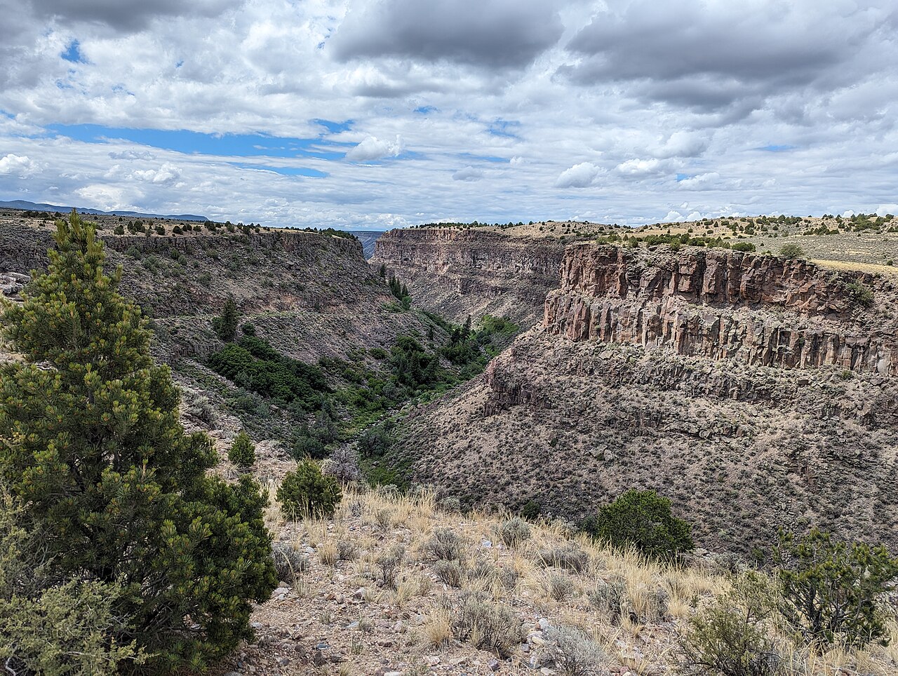
The section described above is part of the Rio Grande Gorge, a 125 km long and up to 300 m deep gorge that the river created itself ages ago to flow through the basalt of the Taos Plateau.
After a long stretch through largely uninhabited territory, the river flows again for the first time about 70 km south of Taos through a small town called Española and from here through the Santa Fe National Forest towards Albuquerque, the largest city in New Mexico.
About 200 km further south begins the Elephant Butte Reservoir, completed in 1916, which extends over a length of about 60 km and an average width of 2.4 km, making it the largest reservoir in New Mexico.
About 40 km downstream is another reservoir, Caballo Lake, built in the 1930s, which is almost 29 km long and was once built to use water drained from Elephant Butte Reservoir to generate electricity.
Elephant Butte Reservoir is located about 8 km north and Caballo Reservoir about 25 km south of the town of Truth or Consequences.
Further downstream, the Rio Grande flows through Las Cruces, the second largest city in the state of New Mexico, which it leaves about 2 miles southwest of the Texas border town of Anthony.
Border river between Texas and Mexico
From the western border of El Paso and the city of Juárez on the other side of the river, the Rio Grande forms the border between the United States and Mexico for about 2,000 km until its mouth in the Gulf of Mexico.
In the 20th century, the river was artificially straightened several times, as a result of which its stretch between El Paso and the former Fort Quitman has now been reduced to almost half: While the natural stretch was 248 km, today it measures only 137 km and is therefore almost identical to the land stretch of about 130 km.
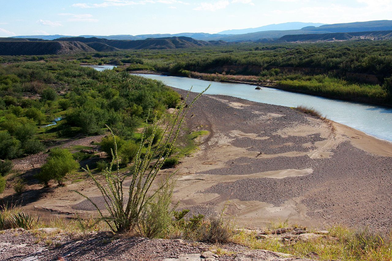
However, the course of the river behind Fort Quitman was not straightened and has been struggling with the problem of insufficient water ever since. Up to the tributary of the Río Conchos some 320 km downstream, shortly before the border towns of Presidio (Texas) and Ojinaga (Chihuahua), the Rio Grande degenerates into a largely invisible body of water that has been almost completely destroyed by the tamarisk trees that are abundant there. This plant was imported from North Africa and Central Asia in the 19th century to stabilize the river basin, but has long been to the river's detriment, which is why the stretch between El Paso and Fort Quitman is now known as "The Forgotten River." "Forgotten" is the name given to the river because it is largely invisible and looks largely as it does in the photo above right, which shows a drought from Big Bend National Park further downstream; for even beyond the tributary of the Río Conchos, the water flows are not always tremendous, although the largest tributary of the Rio Grande, which rises in the Mexican state of Chihuahua, was known, especially in earlier times, for supplying the main river with sufficient water. But apparently an increasing withdrawal of water for irrigation of agricultural land in Chihuahua has ensured that the water volume of the Río Conchos has also decreased considerably and since then the relationship between the US state of Texas and the Mexican state of Chihuahua has become rather tense. But while the farmers in Texas primarily blame Mexico for the low water volume, the Mexican settlers on the other side of the Rio Grande accuse the USA of destroying the river basin by the tamarisk. But there are also considerable discrepancies between the US states of Colorado, New Mexico and Texas regarding the use and transmission of water from the Rio Grande.
A few kilometres past Presidio, the Rio Grande flows for about 95 km along Big Bend Ranch State Park, ending just before Lajitas. Beyond Lajitas, the Rio Grande reaches Big Bend National Park, at the edge of which it forms the border between the USA and Mexico for 393 km. On the Mexican side, after a little more than a third of this distance, the Rio Grande leaves the state of Chihuahua and enters the state of Coahuila.
For the last 111 km of Big Bend National Park, as well as the adjacent 214 km stretch, the river flows through a region called the Rio Grande Wild and Scenic River. It is the only area where the river takes a northerly direction.
A few hundred miles beyond the national park, the Rio Grande flows through Amistad Reservoir. This is located in the Amistad National Recreation Area, where the Pecos River and the Devils River, two of the most important tributaries, join the Rio Grande. From the end of the reservoir, it is 19 km downstream to the Texas city of Del Rio and its Mexican sister city Acuña.
From there, the Rio Grande takes 88 km to the border towns of Eagle Pass (Texas) and Piedras Negras (Coahuila). For the next 92 km to Laredo (Texas) and Nuevo Laredo (Tamaulipas), the Rio Grande leaves the state of Coahuila on the Mexican side behind the town of Hidalgo, which has only about 1,500 inhabitants, and flows along Nuevo León (the only settlement here is the town of Colombia, which has barely 500 inhabitants) for a stretch of only 15 km, before the river continues its last section along the state of Tamaulipas.
Sixty-four kilometers southeast of Laredo and Nuevo Laredo is Falcon Reservoir, with the Mexican Río Salado tributary to the Rio Grande. Halfway between the reservoir and the border towns of Reynosa (Tamaulipas) and McAllen (Texas), the Mexican Río San Juan flows into the Rio Grande at Camargo.
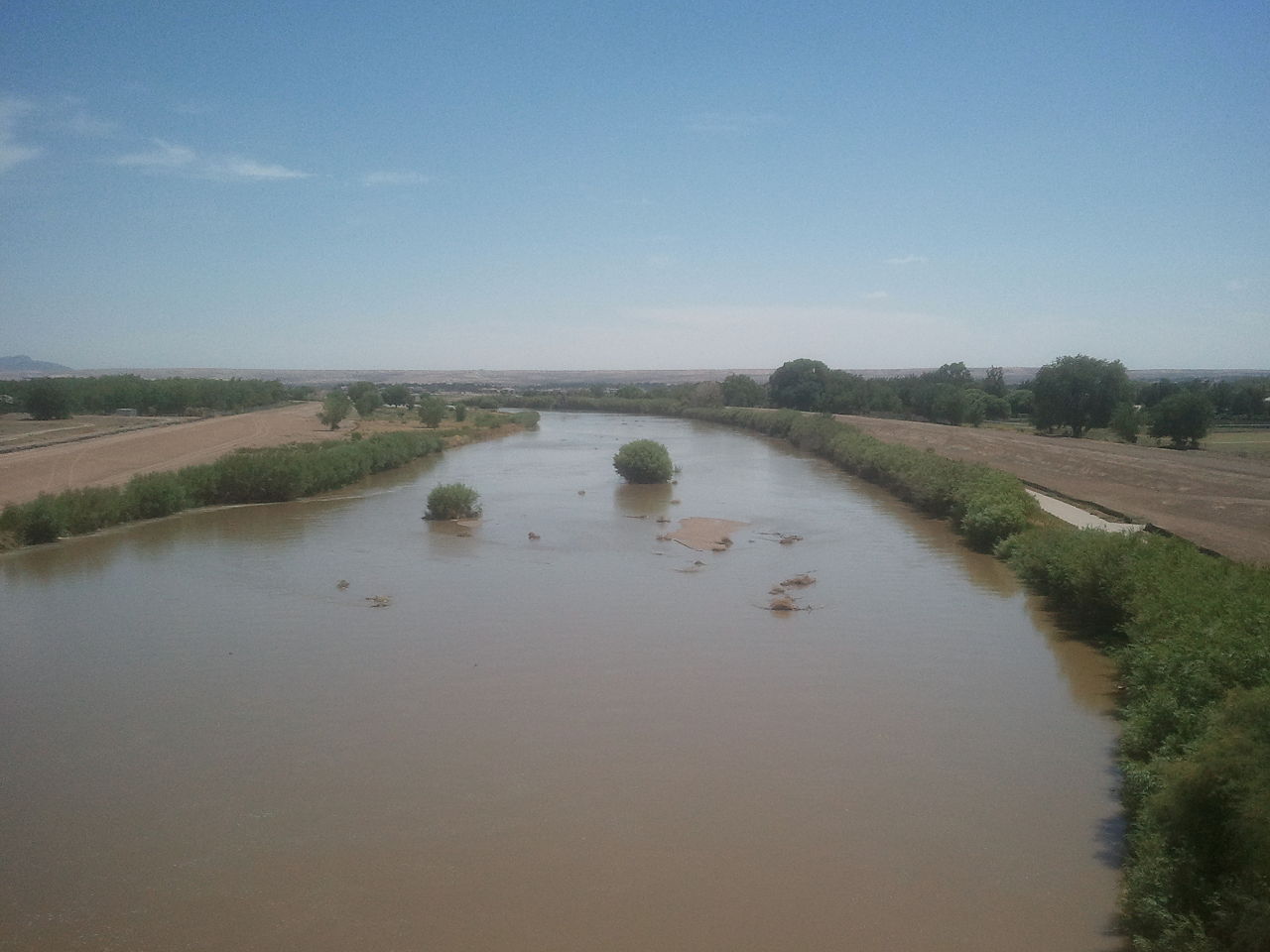
The final stretch of the river passes through Texas' Starr County, Hidalgo County, and Cameron County, all of which are part of the Lower Rio Grande Valley, one of the poorest residential areas in the United States. The two most important cities in the Rio Grande Valley are McAllen, located in Hidalgo County, and its largest city, Brownsville, located further downstream in Cameron County. From there, and from its Mexican sister city Matamoros, it is about 40 km to the mouth of the Rio Grande into the Gulf of Mexico. However, this is the unusual end of a river, as the Rio Grande soon widens out beyond these last two border towns and seeps into the river delta. It is the end of the river rather than its mouth, as Mexican guide Gilberto Rodríguez put it to author Jan Reid. So Jan Reid finally concludes, "We've let the Rio Grande degenerate into a river that can't find its way to the sea."


Related articles
Author
AlegsaOnline.com Rio Grande (Río Bravo): Geography, History, and Environmental Issues Leandro Alegsa
URL: https://en.alegsaonline.com/art/83002