Rio de Janeiro: overview, geography, history and culture
Profile of Rio de Janeiro covering its location, landmarks, history, economy, transport and cultural life, with key distinctions and notable facts.
Overview

Image gallery
10 Images


Geography and notable landmarks
Set along the Atlantic coast, Rio is built around Guanabara Bay and includes famous shoreline neighborhoods such as Copacabana and Ipanema. Dominant physical features include Sugarloaf Mountain (Pão de Açúcar) and the 30‑metre‑tall statue of Christ the Redeemer on Corcovado hill. Urban green areas include Tijuca National Park, a large urban forest within the city limits. Sports and entertainment venues such as the Maracanã stadium, and an international airport (often referred to by the name of Antônio Carlos Jobim) also shape the city’s profile.
History and development
Colonial settlement began in the 1500s. Over centuries Rio grew as a port and administrative center, its economy tied to sugar, coffee and later industrial processing. Remnants of the colonial era survive in landmarks such as the Arcos da Lapa, an aqueduct that once supplied water to the early town; the structure and its route are often described with the original Portuguese name and function (Arcos da Lapa). The city’s urban fabric expanded through the 19th and 20th centuries into a dense metropolitan region of neighboring municipalities.
Economy, suburbs and transport
Rio’s economy combines tourism, services, commerce and manufacturing. Traditional industrial sectors in and around the city have included textiles, food processing, chemicals and metallurgy, while parts of the metropolitan area host heavy industry and logistics hubs (Metropolitan region). Parts of the municipality retain small agricultural areas — for example the suburb of Campo Grande produces local fruits and vegetables. Nearby cities such as Nova Iguaçu and Duque de Caxias are part of the continuous urban agglomeration. Road links connect Rio to other major Brazilian centers; the Presidente Dutra highway links the city to São Paulo, itself the largest metropolis in the region (largest city designation).
Public transport and local features
Within the city, transport includes buses, metro lines and historic systems such as the electric tram or bonde that still runs to some neighbourhoods (bonde). The combination of steep hills, narrow streets and a sprawling coastline has produced a distinctive urban pattern in which formal neighbourhoods sit near informal settlements often referred to as favelas. Conservation areas such as Tijuca and other protected corridors help preserve biodiversity despite urban pressures.
Culture, events and modern role
Rio is internationally renowned for its cultural expressions: samba schools, Carnival parades, bossa nova music and a lively street life. The city hosted the 2016 Summer Olympic Games, an event that prompted investment in venues and transport (2016 Olympics). Tourism remains a major economic driver, with visitors drawn by beaches, festivals and panoramic viewpoints.
Quick facts and reading
- Former national capital: capital until 1960.
- State capital: Rio de Janeiro (state).
- Harbour and bayside geography: Guanabara Bay.
- Local transport historic note: tram (bonde).
- Regional connections and industry corridor along the Dutra: São Paulo connection and metropolitan industry (region).

Geography
Geographical position
Rio de Janeiro is located just north of the Tropic of Capricorn, nestled between the Atlantic Ocean to the south, Guanabara Bay to the east, and the foothills of the Serra do Mar, part of the central Brazilian highlands, to the north and west. The administrative urban area has a surface area of 1182 square kilometers and lies on average 31 meters above sea level. It is characterized by the bays and beaches along the shores, as well as by granite hills called morros, which are part of the foothills of the Serra do Mar.
These granite hills also include Rio's two landmarks, the 394-meter-high Sugarloaf Mountain, located directly on a peninsula in Guanabara Bay, and the 704-meter-high Corcovado with the statue of Christ at its summit. Another is the 533-meter-high Morro Dois Irmãos. The highest point of the urban area is the 1022-meter-high Pico da Tijuca, which lies in the middle of an extensive nature reserve.
The city is divided into two parts by a chain of hills. The Zona Sul (South Zone) stretches along the Atlantic coast with the famous beach districts of Ipanema and Copacabana. The northern part, on the other hand, includes the historic city center and today's business center, as well as the neighborhoods in the north.
City breakdown
See also: Administrative regions of the city of Rio de Janeiro
V - D
Sub-prefectures and districts (bairros) of the city of Rio de Janeiro
| Centro e Centro Histórico | Bairro de Fátima | Catumbi | Centro | Cidade Nova | Estácio | Gamboa | Mangueira | Paquetá | Praça XV | Praça Mauá | Santo Cristo | São Cristóvão | Saúde |
|
| Zona Sul | Bairro Peixoto | Botafogo | Catete | Copacabana | Cosme Velho | Flamengo | Gávea | Glória | Humaitá | Ipanema | Jardim Botânico | Lagoa | Laranjeiras | Leblon | Leme | Rocinha | Santa Teresa | São Conrado | Urca | Vidigal | |
| Zona Norte 1 | Abolição | Acari | Água Santa | Anchieta | Barros Filho | Benfica | Bento Ribeiro | Brás de Pina | Cachambi | Caju | Campinho | Cascadura | Cavalcante | Cidade Universitária | Coelho Neto | Colégio | Cordovil | Costa Barros | Encantado | Engenheiro Leal | Engenho da Rainha | Engenho de Dentro | Engenho Novo | Guadalupe | Honório Gurgel | Irajá | Jacaré | Jardim América | Lins de Vasconcelos | Madureira | Marechal Hermes | Maria da Graça | Oswaldo Cruz | Parada de Lucas | Parque Anchieta | Parque Colúmbia | Pavuna | Penha | Penha Circular | Pilares | Quintino Bocaiúva | Riachuelo | Ricardo de Albuquerque | Rio Comprido | Rocha | Rocha Miranda | Sampaio | São Francisco Xavier | Todos os Santos | Turiaçu | Vasco da Gama | Vaz Lobo | Vicente de Carvalho | Vigário Geral | Vila Cosmos | Vila da Penha | Vista Alegre | |
| Zona Norte 2 | Complexo do Alemão | Del Castilho | Higienópolis | Inhaúma | Jacarezinho | Manguinhos | Méier | Piedade | Tomás Coelho | | |
| Zona Norte 3 (Ilha do Governador) | Bancários | Bonsucesso | Cacuia | Cocotá | Freguesia da Ilha | Fundão | Galeão | Ilha do Governador | Jardim Carioca | Jardim Guanabara | Maré | Moneró | Olaria | Paquetá | Pitangueiras | Portuguesa | Praia da Bandeira | Ramos | Ribeira | Tauá | Tubiacanga | Zumbi | |
| Zona Oeste | Bangu | Barra de Guaratiba | Campo dos Afonsos | Campo Grande | Cosmos | Deodoro | Gericinó | Guaratiba | Inhoaíba | Magalhães Bastos | Paciência (Rio de Janeiro) | Padre Miguel | Pedra de Guaratiba | Realengo | Santa Cruz | Santíssimo | Senador Camará | Senador Vasconcelos | Sepetiba | Vargem Grande | Vargem Pequena | Vila Militar | |
| Barra e Jacarepaguá | Barra da Tijuca | Anil (Rio de Janeiro) | Camorim | Cidade de Deus | Curicica | Freguesia | Gardênia Azul | Grumari | Itanhangá | Jacarepaguá | Jardim Sulacap | Joá | Pechincha | Praça Seca | Recreio | Taquara | Tanque | Vila Valqueire | |
| Tijuca e Adjacências | Alto da Boa Vista | Andaraí | Grajaú | Maracanã | Praça da Bandeira | Vila Isabel | Tijuca | |
In addition to the 8 subprefectures (subprefeituras) and 160 districts (bairros), the city of Rio de Janeiro is divided into 34 administrative regions (Regiões Administrativas).
Rio de Janeiro is divided into 4 geographical regions (North, South, West and Central), which are further subdivided into 8 sub-prefectures (Subprefeituras), 33 administrative regions (Regiões Administrativas) and 160 districts (Bairros). These are in turn statistically assigned to five planning areas (Áreas de Planejamento). The planning areas are:
- Área de Planejamento 1: Centro, Paquetá, Portuária, Rio Comprido, Santa Teresa, São Cristóvão
- Área de Planejamento 2: Botafogo, Copacabana, Lagoa, Rocinha, Tijuca, Vila Isabel
- Área de Planejamento 3: Anchieta, Complexo do Alemão, Ilha do Governador, Inhaúma, Irajá, Jacarezinho, Madureira, Maré, Méier, Pavuna, Penha, Ramos, Vigário Geral
- Área de Planejamento 4: Barra da Tijuca, Cidade de Deus, Jacarepaguá
- Área de Planejamento 5: Bangu, Campo Grande, Guaratiba, Realengo, Santa Cruz
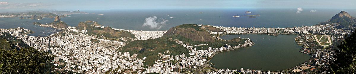
enlarge and show information about the picture
![]()
View from Corcovado over Botafogo, Urca and the Sugar Loaf (left), Leme (middle), Ipanema, Leblon and Lagoa (right)
Climate
Due to Rio de Janeiro's location in the low latitudes, on the Atlantic Ocean and Guanabara Bay, the city's climate is tropical with twelve humid months. A warm climate dominates, but is tempered by the steady trade winds.
The highest temperature in Rio de Janeiro was officially measured on 14 January 1984 at the weather station in the Bangu district with 43.2 °C, the lowest on 19 July 1926 at the weather station in the Campo dos Afonsos district with 4.8 °C.
The average annual temperature is 22.6 °C with only slight monthly variations (maximum temperature in January/February: 25.5 °C, minimum temperature in July: 20.2 °C) and an average annual precipitation of 1173 millimetres. The highest precipitation falls in the months of December to April, when it is summer in the southern hemisphere. The least precipitation falls in the winter months of July and August.
| Temperature and precipitation in the long-term mean (1961-1990)
Source: World Meteorological Organization; | ||||||||||||||||||||||||||||||||||||||||||||||||||||||||||||||||||||||||||||||||||||||||||||||||||||||||||||||||||||||||||||||||||||||||||||||||||||||||||||||||||||||||||||||||||||||||||||||||||||||||||||||||||||||||||||||||||||||||||||||||||||||||||||

History
Colonial Times
According to the Treaty of Tordesillas, the Portuguese laid claim to the territory of present-day Brazil discovered at the end of the 15th century. France, however, did not recognize the treaty and in 1555 founded Fort Coligny on the Ilha do Serigipe off the coast of present-day Rio de Janeiro under Vice Admiral de Villegagnon; the territory controlled from here was named France Antarctique. On the opposite coast, de Villegagnon then founded the settlement of Henriville. At that time, Tupi Indians of the Tamoios and Tupinambás tribes, with whom the French allied themselves, lived in this region. It was not until ten years later, in 1565, that the French were driven from there by the Portuguese, who then founded the city of São Sebastião do Rio de Janeiro on March 1, 1565, at what is now Morro do Castelo.
In 1680, Rio de Janeiro became the capital of the southern regions of Brazil; at that time, the settlement was one of the most important Portuguese bases on Brazilian territory, with a population of around 4,000. Since 1700, Rio de Janeiro developed into the most important port city in Brazil, mainly triggered by gold discoveries in the neighboring region of Minas Gerais.
Although the city was attacked and occupied by the French in 1710/1711 (→ Battle of Rio de Janeiro) and was only able to obtain the withdrawal of the French for a large ransom, it recovered rapidly in the following years and became the capital of the Viceroyalty of Brazil on 27 January 1763.
Rio de Janeiro experienced a significant further increase in importance in 1808, when the Portuguese court fled there in connection with the French invasions to escape Napoleon's forces marching on Lisbon. Along with the court, a large number of artists, scientists and nobles moved to Brazil, and the city's economic and cultural life underwent an enormous transformation. The Brazilian National Library, for example, traces its origins to the holdings brought by the Portuguese royal family. In 1815, Rio de Janeiro became the capital of the United Kingdom of Portugal, Brazil and the Algarves.
In the course of this, many colonial restrictions were lifted, which greatly promoted economic development and triggered a population explosion that lasted until the 1980s. Within just under a hundred years, the population had risen to over 500,000 inhabitants (1891) and reached approximately five million by 1980.
In the early 19th century, Rio became a transshipment point for the African slave trade in South America. About 900,000 slaves reached the continent via the Valongo wharf in the city center, which was started in 1811.
Independence
The Portuguese royal court returned to Portugal in 1822, as a result of the Liberal Revolution that broke out in Portugal in 1820. After the departure of the Portuguese court, Brazil declared itself the independent Empire of Brazil under Prince Dom Pedro de Alcântara. Rio de Janeiro retained the status of capital, where the prince now resided as Emperor Pedro I. Due to succession disputes in Portugal and domestic political problems in Brazil, he abdicated in 1831, leaving his underage son behind. He ascended the throne as Dom Pedro II in 1840. Among other things, he initiated the construction of a railway, the first section of which was opened in Rio de Janeiro in 1858, followed by the Companhia Ferro-Carril de São Cristóvão in 1873.
Even when Brazil became a republic in 1889 following a military coup, Rio de Janeiro remained the capital. In the first half of the 20th century, Rio de Janeiro experienced a social flourishing, as the city became a destination for movie stars and international high society. Some Portuguese writers, such as the writer and translator Jorge de Sena, sought refuge in Rio de Janeiro from the "Estado Novo" authoritarian dictatorship in Portugal founded by António de Oliveira Salazar. A final cultural outgrowth of this era was the emergence of Brazilian jazz bossa nova from 1957 onwards, which became world famous through songs such as Garota de Ipanema/The Girl from Ipanema by Antônio Carlos Jobim and Vinícius de Moraes.
Due to the emergence of mass tourism in the second half of the 20th century, the image of the districts close to the beach in particular has changed considerably, which today is characterised above all by numerous hotels, while the districts further away from the sea have been characterised above all by increasing slumming, known as favelas.
In 1960, Rio de Janeiro lost its status as capital to the newly built city of Brasília under Juscelino Kubitschek. At the same time, the city became an independent city-state of Guanabara, which was merged with the state of Rio de Janeiro in 1975. The city became the capital of the new state. The city gained international political attention again in 1992, when the UN Environment Summit was held there.
As a venue for the 2014 World Cup and as host of the 2016 Summer Olympics, the city once again attracted the world's attention, but after that it was only able to stay afloat financially with the help of the federal government.


Questions and answers
Q: What is the population of Rio de Janeiro?
A: According to the 2000 Census, the city had 5,473,909 people.
Q: When did Eduardo Paes become Mayor of Rio de Janeiro?
A: In 2008 Eduardo Paes became Mayor.
Q: What is the name of a famous mountain in Rio de Janeiro?
A: Sugar Loaf Mountain (in Portuguese, Pão de Açúcar) is a famous mountain in Rio de Janeiro.
Q: What type of industries are located in and around Rio de Janeiro?
A: Industries such as textiles, food, chemicals, and metallurgy are located in and around Rio de Janeiro. Most of these industries are located in the northern and western suburbs of the city.
Q: How far away from São Paulo is Rio de Janeiro?
A: The cities of Rio and São Paulo are linked by the Presidente Dutra Highway (also known as Via Dutra), which is 420 kilometers (about 261 miles) away from São Paulo.
Q: When was Tijuca National Park created? A: Tijuca National Park was created in 1961.
Q:When did Brazil host the Summer Olympic Games?
A:Brazil hosted the Summer Olympic Games in 2016.
Related articles
Author
AlegsaOnline.com Rio de Janeiro: overview, geography, history and culture Leandro Alegsa
URL: https://en.alegsaonline.com/art/82995
Sources
- newclimateeconomy.net : newclimateeconomy.net