Rhön: low mountain region in central Germany
The Rhön is a volcanic-origin low mountain range in central Germany spanning Hesse, Bavaria and Thuringia, known for hiking, gliding, traditional farms and the Rhön Biosphere Reserve (UNESCO, 1991).
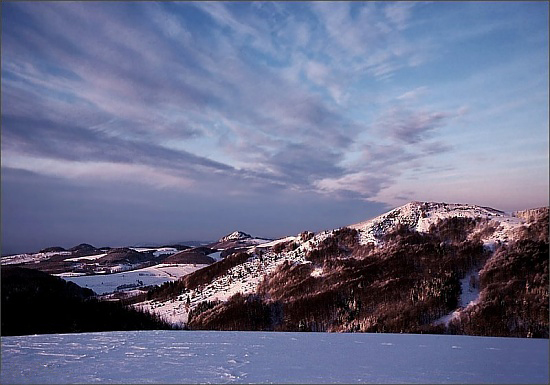
The Rhön is a compact, rolling low mountain region in central Germany that straddles three federal states: Hesse, Bavaria and Thuringia. Its landscapes combine open plateaus, rounded basalt cones and valleys, and the area is widely appreciated for scenic views, traditional agriculture and a long history of human settlement. Although modest in elevation compared with the Alps, the Rhön's character and geology make it a distinct part of Germany's Mittelgebirge (low mountain) region.
Image gallery
10 Images


Geology and landscape
The Rhön was shaped by ancient volcanic activity that left basaltic summits, lava flows and volcanic domes. These remnants of extinct volcanism lend a patchwork of heath, grassland and rocky outcrops that contrast with surrounding forested ranges. The Rhön is separated from the Vogelsberg mountains by the valley of the Fulda River, and the two areas are often compared because both owe much of their relief to past volcanic events; the nearby Vogelsberg itself is a large volcanic complex (Vogelsberg).
Highest summits and notable forms
- Wasserkuppe — the region's highest and most famous peak, long associated with gliding and meteorology.
- Heidelstein — a broad, exposed ridge valued for views and seasonal flora.
- Kreuzberg — known for its monastery and compact basalt shape.
- Milseburg and Ellenbogen — other prominent domes that frame the central Rhön.
These summits are accessible by an extensive network of marked trails. Hikers and walkers use nearly 6,000 km of paths that cross heath, meadow and woodland, offering routes for short day trips or longer multi-day treks.
Ecology and protection
In 1991 the Rhön was designated a UNESCO Biosphere Reserve to promote a balanced relationship between conservation and sustainable local development (UNESCO). The reserve highlights the mosaic of semi-natural grasslands, raised bogs and beech woods, and protects a range of plant and animal communities, including rare orchids, ground-nesting birds and insect assemblages associated with extensive pastoral land use. Management emphasizes traditional farming practices, biodiversity-friendly grazing and visitor education.
Human use, tourism and culture
The Rhön has a long tradition of recreational aviation: sailplane pilots have flown from the ridges here since the early 20th century, attracted by reliable updrafts and open slopes (gliding). Walking and cycling paths draw outdoor enthusiasts (hikers), while rural tourism includes stays on working farms and guesthouses that offer local cuisine and an insight into regional life (farm stays). Small market towns and hamlets preserve regional architecture, folk customs and seasonal festivals, and historic chapels, observation towers and ruins add cultural interest for visitors.
Conservation and tourism are coordinated across state and local authorities to reconcile visitor pressure with habitat protection. The Rhön's mix of open summits, traditional land use and geological interest makes it a useful example of how natural and cultural landscapes can be managed together for recreation, research and rural livelihoods.
Further information about the Rhön's geology, routes and conservation initiatives can be found via regional guides and local authorities (volcanic heritage, Vogelsberg context, Fulda valley, and local tourism offices). Practical resources and maps are available from hiking associations and visitor centers (central Germany, Hesse, Bavaria, Thuringia), while conservation projects often publish species lists and habitat surveys online (UNESCO, trail guides, agritourism).
Those planning a visit should respect seasonal access rules, follow marked paths and consult local information on weather and protected areas to help preserve the Rhön's open panoramas and biological diversity for future generations.
Questions and answers
Q: Where are the Rhön located?
A: The Rhön are located in central Germany, in the states of Hesse, Bavaria and Thuringia.
Q: What is the geological origin of the Rhön?
A: The Rhön are the product of ancient volcanic activity.
Q: How are the Rhön separated from the Vogelsberg Mountains?
A: The Rhön are separated from the Vogelsberg Mountains by the Fulda River and its valley.
Q: What are the main activities that tourists can enjoy in the Rhön?
A: Tourists can enjoy hiking on nearly 6,000 km of tracks through the picturesque scenery and gliding, which has been done there since the early twentieth century. Nowadays, people also come to stay on a farm during holidays.
Q: When was the Rhön declared a Biosphere Reserve by UNESCO?
A: The Rhön was declared a Biosphere Reserve by UNESCO in 1991.
Q: What is the highest mountain range in the Rhön?
A: The highest mountain range in the Rhön is not specified in the text.
Q: What is the significance of the Rhön being a Biosphere Reserve?
A: The Rhön being a Biosphere Reserve means that it is recognized as an important ecosystem for sustainable development and nature conservation.
Related articles
Author
AlegsaOnline.com Rhön: low mountain region in central Germany Leandro Alegsa
URL: https://en.alegsaonline.com/art/82539