Rhineland
![]()
The title of this article is ambiguous. For other meanings, see Rhineland (disambiguation).
Rhineland (often abbreviated Rhld., Latin Rhenania) refers to not more precisely defined areas on the German Middle and Lower Rhine.
The term for the originally Frankish-populated areas only came into use around 1800, after France had annexed the parts of the Electoral Palatinate on the left bank of the Rhine. It essentially comprised the territories of a few small duchies on the Rhine, the imperial city of Aachen, and the Catholic territorial areas of the archbishoprics of Cologne, Mainz, and Trier.
With the reorganization of Europe in 1815, the territories on the left bank of the Rhine were divided between Prussia, Hesse-Darmstadt and Bavaria. Bavaria named its Wittelsbach-Palatinate territories Rheinkreis, Pfalz or Rheinpfalz, while the Grand Duchy of Hesse (Hesse-Darmstadt) called its new province Rheinhessen. Prussia, in turn, combined the province of the Grand Duchy of the Lower Rhine and the province of Jülich-Kleve-Berg in 1822 to form the Rhine Province. For the later, sometimes quite complex developments (Allied occupation of the Rhineland after 1918, division into the federal states of Hesse, Rhineland-Palatinate, Saarland and North Rhine-Westphalia, decision-making for today's division, identity issues, cultural region of the Rhineland, etc.), see the following two sections.
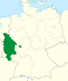
Prussian Rhine Province (green), anno 1830 .
The term "Rhineland"
One can only speak of the Rhineland as a comprehensive designation for the areas on the Middle and Lower Rhine with a uniform political and social structure from 1797 onwards with the state integration of the left bank of the Rhine into revolutionary France. The unification of all the French-occupied lands on the left bank of the Rhine, from the Electoral Palatinate to the Duchy of Cleves, which was first temporarily planned as the Cisrhenian Republic, was not carried out. Instead, the entire left territory from the Electoral Palatinate onwards was annexed by France. The four new French departments formed in the process were Roer, Rhine-Moselle, Saar and Donnersberg.
Before that, this area was essentially divided between various duchies and the Catholic "territorial areas" of the three electorates of Cologne, Mainz and Trier, in which the archbishops also held secular power as electors. In addition, there were various counties, smaller enclaves, dominions, abbeys and the two large and ancient imperial cities of Aachen and Cologne in this entire area. The inhabitants of the various duchies, counties, archbishoprics and free imperial cities were therefore also not called Rhinelanders until 1797 and for many centuries, but Berger, Geldener, Jülicher, Klever, Kölner and Kurkölner and so on. All these territories had their own authorities with a wide variety of laws and regulations and a legally privileged upper class, the members of the nobility. Even the geographical term "Rhineland" was not applied until the end of the 18th century, accordingly the inhabitants of these territories could not be "Rhinelanders".
After the Congress of Vienna in 1815, the territories lying on the left bank of the Rhine were divided between Prussia, Hesse and Bavaria. Bavaria called its territory on the left bank of the Rhine, which largely corresponded to the former Electoral Palatinate with the territories of the Palatine collateral lines of the Wittelsbach dynasty, Rheinkreis (later Pfalz or Rhine Palatinate), while the Grand Duchy of Hesse called its left bank province Rheinhessen. The Prussian territories comprised most of the formerly French-annexed left bank of the Rhine, to which was added, on the right bank, essentially the territory of the Grand Duchy of Berg bequeathed by Napoleon Bonaparte. The modern legal and communal order introduced by France was largely adopted in these areas. The Napoleonic Code civil as a civil legal order continued to exist in all territories on the left bank of the Rhine until the entry into force of the Civil Code on 1 January 1900.
The entire Prussian territories were initially combined into two provinces, the Grand Duchy of the Lower Rhine and the Province of Jülich-Kleve-Berg, and then united into a single Rhine Province from 1822. The province consisted of the administrative districts of Aachen, Düsseldorf, Cologne, Coblenz and Trier. Especially for this province the name Rhineland became established, also in its Latinized form Rhenania. Since before the 19th century only the northern areas up to about the mouth of the Ruhr had belonged to Prussia until the unification into the Rhine province, and the new acquisitions were also predominantly Catholic, there was also resistance among Protestant Prussians against integration into the new rule. Separatist counter-movements formed, which one also wanted to undermine by the historicizing term Rhineland with the formation of research institutions for the regional-historical common history of the Rhineland. These separatist tendencies, which still led to the attempt to form a Rhenish Republic in 1923, could not prevail in the end.
After the First World War, the term Rhineland temporarily acquired a new level of meaning as a result of the Allied occupation of the Rhineland in 1918/19. When people spoke of the occupied Rhineland, they meant not only the whole of Germany on the left bank of the Rhine, but also the "bridgeheads" (30-km zone) around Cologne, Koblenz and Mainz that were occupied on the right bank of the Rhine.
The Rhineland in this sense is distributed among Hesse, North Rhine-Westphalia, Rhineland-Palatinate and Saarland in the German post-war order as a result of the occupation zones established by the Allies after World War II. New territorial divisions divided the Rhineland into the Lower Rhine of North Rhine-Westphalia and the Middle Rhine of Rhineland-Palatinate; only a small part of the northern Middle Rhine is now also part of the state of North Rhine-Westphalia. Rhineland-Palatinate includes the greater part of the areas on the Middle Rhine, including the areas on the right bank of the Rhine below the height of Bonn to the Rheingau-Taunus district, as well as Rhinehesse and the former Bavarian Rhine Palatinate, while Hesse no longer has any territory on the left bank of the Rhine. A special status, as already temporarily after the First World War, had briefly until 1 January 1957 the Saarland.
In a narrower sense, one now often refers only to the North Rhine-Westphalian part when speaking of the Rhineland; thus one often speaks of the Rhineland Regional Association as an abbreviation. For the Evangelical Church in the Rhineland, the original extent of the church province, which is congruent with the territorial status of the Prussian Rhine Province, has not changed over all historical upheavals.
Common geographical definition
Although the term Rhineland cannot be precisely defined in geoscientific terms, it has been used almost uniformly in linguistic usage since the post-war order:
The Rhineland part of North Rhine-Westphalia borders the Netherlands to the north and west, Belgium to the southwest and Westphalia to the east. The part of Rhineland-Palatinate borders on Belgium and Luxembourg in the west, on Saarland (formerly also part of the Rhineland) in the southwest and on the North Palatinate mountains and Rhine-Hessian Switzerland in the south. To the east it borders on Hesse, to the northeast on Westphalia. The highest elevation of the North Rhine-Westphalian part of the state is the mountain Weißer Stein with 689 m, located in the Eifel. The Erbeskopf in the Hunsrück is with 816 m the highest elevation of the Rhineland-Palatinate part and thus of the Rhineland as a whole and also the highest German mountain left of the Rhine, which flows through the country from southeast to northwest. Between Bingen and Bonn it cuts through the Rhenish Slate Mountains. The low mountain range bordering the North German Plain runs east of the Rhine along the lower reaches of the Ruhr, then south roughly on the line Mülheim an der Ruhr-Solingen-Bergisch Gladbach-Bonn, then west to northwest in an arc via Düren to Aachen.
The theory put forward here, that Rheinhessen with Mainz is to be counted as part of the Rhineland, is opposed by authoritative regional institutions that do not see it that way at all. Nowhere in these essays is a reference to the Rhineland to be found.
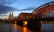
Cologne Rhine panorama with the cathedral (left) and the Hohenzollern bridge
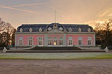
Benrather Castle in the south of Düsseldorf
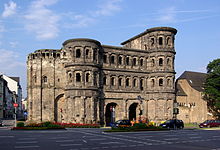
City gate Porta Nigra in Trier, the former Roman Augusta Treverorum
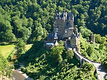
Castle Eltz above the Elzbach in the East Eifel (Maifeld)
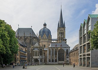
Aachen Cathedral, the burial place of Charlemagne with pre-Romanesque octagon (centre). Until 1531, 31 Roman or Roman-German kings were crowned here.
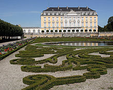
Electoral Cologne Augustusburg Palace in Brühl
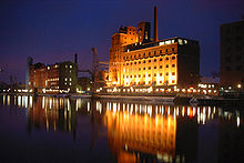
Former warehouse row in Duisburg's inner harbour repurposed for offices and leisure activities
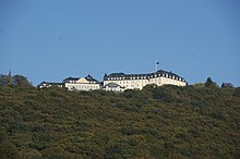
Petersberg with Federal Guest House in the Siebengebirge (Königswinter near Bonn)
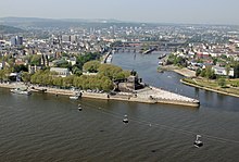
Mouth of the Moselle into the Rhine at the Deutsches Eck in Koblenz
Questions and Answers
Q: What does the word Rhineland mean now?
A: The Rhineland now refers to areas of Germany along the middle and the lower Rhine.
Q: What countries border on the Rhineland?
A: Luxembourg, Belgium, and the Netherlands border on the Rhineland to the west, and the Rhine River borders the region to the east.
Q: What happened to the German and Dutch-speaking areas in the middle and lower Rhine after the French were defeated?
A: The German and Dutch-speaking areas in the middle and lower Rhine were added to the Kingdom of Prussia and were called the Rhine Province.
Q: What happened to the western part of the Rhineland after World War I?
A: The western part of the Rhineland was under Allied control and was demilitarized with no military activities allowed, under the Treaty of Versailles.
Q: When did German forces send armies back to the Rhineland?
A: German forces sent armies back to the Rhineland in 1936, three years before World War II began.
Q: What was the Rhineland previously known as?
A: The Rhineland was previously known as an area on both banks of the Rhine in Central Europe.
Q: What is the German word for the Rhineland?
A: The German word for the Rhineland is Rheinland.
Search within the encyclopedia