Reykjavík
![]()
Reykjavik is a redirect to this article. For the Canadian village, see Reykjavik (Manitoba).
Reykjavík [ˈreicaˌviːk] is the capital of Iceland and the northernmost capital in the world (latitude 64° 08' N, 269 kilometres south of the Arctic Circle). The city forms the municipality of Reykjavíkurborg (isl. City of Reykjavík) with some rural areas and quite a few islands. Reykjavíkurborg is by far the largest municipality in the seven-municipality Höfuðborgarsvæðið (literally: the capital area). A total of 202,341 people lived in this densely populated municipality at the end of 2010.
The name Reykjavík is the Icelandic word for "smoke bay"; it probably comes from the fumes of the hot springs in the area and is attributed to a misunderstanding by the first settler Ingólfur Arnarson. The town is the oldest permanent settlement in the country. Although the first settlers populated the land as early as 870 AD, the area grew very slowly and was not officially elevated to a town until 1786.
Reykjavík is Iceland's largest city, with a population of 128,793 as of 1 January 2019; it is home to approximately 37.3% of the country's total population. Over 200,000 people live in the metropolitan region of Reykjavík. The city is located on the Atlantic Ocean, more precisely on Faxaflói Bay below the approximately 900-meter-high local mountain Esja.
The city is home to most of the country's university faculties and various other colleges, theatres, museums and cultural institutions, as well as a deep-sea port. In the middle of the city lies a small lake called Tjörnin. This lake is also one of the largest breeding grounds for water birds in the southwest of Iceland.

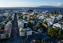
Reykjavík from the tower of Hallgrímskirkja
Geography
Location
Reykjavík is located in the southwest of the island at the foot of the Reykjanesskagi peninsula, but the sparsely populated suburbs extend far to the south and east. The zone of plate tectonic shift that crosses Iceland from southwest to northeast also passes over this peninsula. Therefore, earthquakes are more frequent, but usually of low magnitude.
The city's coastline is characterized by (semi-)islands, caves and straits. During the last ice age (until about 10,000 years ago), parts of today's city area were covered by glaciers, other parts were below the waterline. During warm periods and at the end of the Ice Age, some of today's hills (such as Öskjuhlíð) were islands. The Öskjuhlíð and Skólavörðuholt hills are former shield volcanoes that were active during the warmer periods of the Ice Age. At 914 metres high, Esja is the highest mountain in the area.
The largest river that crosses Reykjavík is called Elliðaár, is not navigable and is known for its abundance of salmon. South and southwest of the capital is the nature reserve Heiðmörk.
Just a short distance from the Arctic Circle, Reykjavík receives only four hours of sunlight on the shortest days of the year. In summer, the nights are as bright as during the day.
Climate
Reykjavík is located in the subpolar climate zone. However, due to its location directly on the coast and close to the Gulf Stream, the city's climate has a significant maritime character. This results in a relatively small temperature difference between the individual seasons with comparatively mild winters and cool summers. Since the beginning of the 20th century, mean annual temperatures have fluctuated between 3 °C and 6.5 °C.
In winter, temperatures rise to just above freezing on average during the day and fall to just below freezing at night. Temperatures below -10 °C are rarely measured, despite the location just below the Arctic Circle. The lowest temperature ever measured is -24.5 °C (on 21 January 1918).
In summer, temperatures reach around 15 °C during the day, while it usually cools down to below 10 °C at night. Warm days with values above 20 °C are recorded only occasionally. The highest temperature ever measured is 25.7 °C (on 30 July 2008).
Precipitation (0.1 mm and more) falls on average on 148 days per year. The potential evaporation reaches 400 mm per year. The annual sum of sunshine duration is about 1,250-1,300 hours. May is the sunniest month of the year with an average of just over 6 hours per day, whereas December and January do not even reach an average of 1 hour of sunshine per day.
Places with similar climates are Tórshavn (Faroe Islands) and Dutch Harbor (Alaska) in the northern hemisphere, and Ushuaia (Argentina) and Stanley (Falkland Islands) in the southern hemisphere.
| Reykjavík | ||||||||||||||||||||||||||||||||||||||||||||||||
| Climate diagram | ||||||||||||||||||||||||||||||||||||||||||||||||
| ||||||||||||||||||||||||||||||||||||||||||||||||
| Monthly average temperatures and precipitation for Reykjavík
Source: | ||||||||||||||||||||||||||||||||||||||||||||||||||||||||||||||||||||||||||||||||||||||||||||||||||||||||||||||||||||||||||||||||||||||||||||||||||||||||||||||||||||||||||||||||||||||||||||||||||||||||||||||||||||||||||||||||||||||||||||||||||||||||||||||||||||||||||||||||||||||||||
City breakdown
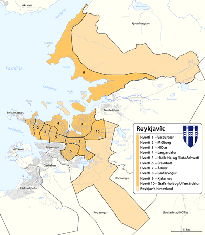
Reykjavík is divided into ten municipalities (hverfi):
| No. | Borough | surface km² | Population2010 |
| 1 | Vesturbær | 2,9 | 15.703 |
| 2 | Miðborg | 3,6 | 8.618 |
| 3 | Hlíðar | 3,3 | 9.612 |
| 4 | Laugardalur | 6,4 | 15.239 |
| 5 | Háaleiti og Bústaðir | 4,3 | 13.755 |
| 6 | Breiðholt | 5,5 | 20.646 |
| 7 | Árbær | 6,1 | 10.192 |
| 8 | Grafarvogur | 14,0 | 18.130 |
| 9 | Kjalarnes | 61,7 | 834 |
| 10 | Grafarholt og Úlfarsárdalur | 22,5 | 5.416 |
| - | Græni Trefillinn1) | 144,2 | - |
|
| Reykjavík | 274,5 | 118.145 |
1)Green belt (Reykjavík hinterland)
In the official statistics of Iceland 31 statistical districts are shown for Reykjavík or the capital municipality Reykjavíkurborg as a further subdivision of the Hverfi.


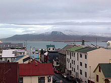
Reykjavík: In the foreground the street Vítastígur, in the background the river Esja.
Population development (Reykjavíkurborg municipality)
| 1801 | 1860 | 1901 | 1910 | 1920 | 1930 | 1940 | 1950 | 1960 | 1970 | 1980 | 1985 | 1990 | 1995 | 2003 | 2006 | 2008 | 2009 |
| 600 | 1.450 | 6.321 | 11.449 | 17.450 | 28.052 | 38.308 | 55.980 | 72.407 | 81.693 | 83.766 | 89.868 | 97.569 | 104.258 | 113.387 | 116.446 | 118.861 | 121.230 |
More than 200,000 inhabitants live in the metropolitan region of Reykjavík. Five of Iceland's municipalities are located in the capital region: Garðabær: population 16,299, Hafnarfjörður: population 29,799, Kópavogur: population 36,975, Mosfellsbær: population 11,463 and Seltjarnarnes: population 4664 (as of 1 January 2019).
Search within the encyclopedia