Regensburg — historic city on the Danube
Regensburg is an eastern Bavarian city on the Danube, known for its exceptionally preserved medieval old town, the Stone Bridge and St. Peter's Cathedral. It is a regional cultural, economic and university centre.
Overview
Regensburg is a city in the east of the German state of Bavaria that lies on the Danube. It has a long urban continuity from the Roman period to the present and a compact, well-preserved medieval centre. The city hosts around 138,000 inhabitants and functions as an administrative, cultural and educational hub. The Czech name for Regensburg, appearing in historic sources, is Řezno.
Image gallery
10 Images


Landmarks and urban character
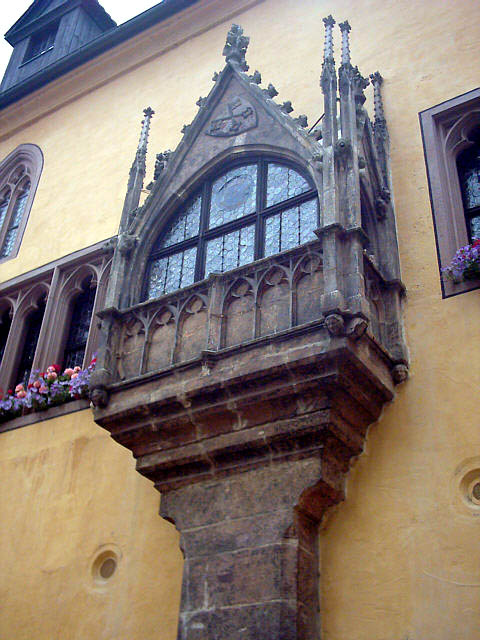
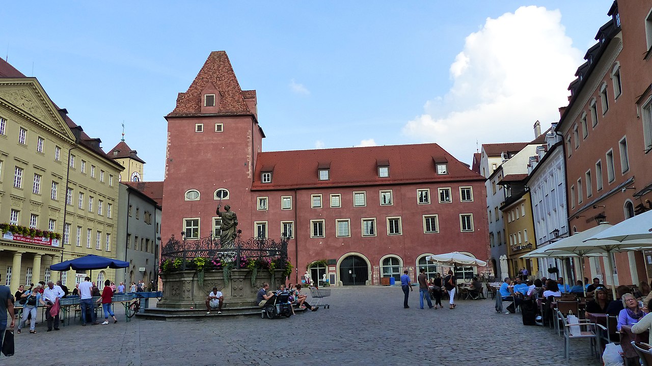
Regensburg's historic core preserves layers of Roman, medieval and later architecture. The Stone Bridge (Steinerne Brücke), built in the 12th century, was for centuries a major crossing of the Danube and a key element of north–south European trade routes. Dominating the skyline is St. Peter's Cathedral (Regensburger Dom), a high Gothic church noted for its twin towers and stained-glass windows. The Old Town Hall, patrician houses with inner courtyards, and riverside streets create a distinctive urban ensemble that attracts many visitors.
- Stone Bridge (Steinerne Brücke)
- St. Peter's Cathedral (Regensburger Dom)
- Old Town Hall and historic merchant houses
- Remnants of the Roman castrum and Porta Praetoria
History
Founded as the Roman castrum Castra Regina, Regensburg developed into an important medieval trading centre and later was recognised as a Free Imperial City. Over the centuries it preserved many public and private buildings. In the early modern period the city became the seat of the Imperial Diet on several occasions and hosted long-term assemblies that shaped regional politics. Its well-preserved ensemble of streets and buildings has led to formal recognition of the value of the old town for heritage and history.
Economy, education and culture
Modern Regensburg combines heritage tourism with a diversified economy that includes manufacturing, high-technology firms and a lively service sector. Higher education and research are important: the city is home to the University of Regensburg and several institutes, which contribute to cultural life, research and a student population that animates nightlife and the arts. Cultural offerings range from museums and classical concerts to seasonal markets and street festivals.
Transport and context
Regensburg is well connected by road and rail to other German cities and lies on important regional routes. The Danube has historically shaped transport and commerce; today river tourism and cruises help interpret the city's history. For broader context about the country and federal state, see information on Germany and Bavaria.
Visiting
The compact old town is best explored on foot, where narrow lanes, market squares and riverside promenades reveal the character of the city. Guided walks, specialist tours and seasonal events provide varied ways to experience Regensburg's history, architecture and living traditions.


Geography
Geographical location
Regensburg is located at the northernmost point of the Danube and at the mouths of the left tributaries Naab and Regen. Two Danube islands are located in the city area, the Obere Wöhrd (eastern tip Jahninsel below the Steinernes Brücke) and the Untere Wöhrd. Today's Stadtamhof district, a small Bavarian town until 1924, originally formed the northern bank of the Danube and also became an island after 1970, separated by the construction of the Europe Canal. This canal functions as a navigation bypass for the Steinerne Brücke and for the old town of Regensburg.
Four very different large natural areas meet in the urban area:
- the Franconian Jura,
- the Bavarian Forest,
- the Danube plain or the Lower Bavarian loess plain (Gäuboden) and
- the Lower Bavarian Tertiary hill country.
These natural spaces shape the urban body in form and extent, the city is situated in a classic "gateway location" at a transition point between topographical narrowness and expanse. The Danube leaves the hills and mountains here and flows into the Gaeuboden plain. This results in little or no expansion potential for the districts to the north and west. All future urban expansion areas are located in the east and south of the city, i.e. in the large Danube plain and in the relatively flat foothills of the Lower Bavarian tertiary hill country.
The historic Bavarian Iron Road, which connects numerous industrial and cultural monuments, ends in Regensburg. Metals and semi-finished products from the Upper Palatinate were transported on this road to the Regensburg transhipment centre. In its last section from Amberg, the Iron Road runs for 60 km as a waterway of the rivers Vils and Naab until the Naab flows into the Danube at Regensburg.
Neighboring communities
The following cities and municipalities, which belong to the district ofRegensburg, border the city of Regensburg. They are named clockwise starting in the north: Lappersdorf, Zeitlarn, Wenzenbach, Tegernheim, Barbing, Neutraubling, Obertraubling, Pentling, Sinzing and Pettendorf.
City breakdown
Until the beginning of the 19th century, Regensburg was limited to the area of the old Roman camp and the areas to the west and east of the city, which were first enclosed by city walls in the 10th century and then extended in the 14th century. Since the 12th century, the city area of Regensburg, limited by the Danube and the course of the city wall, was divided into eight guards, each of which was presided over by a guard lord who had police and military powers. Until 1663 the guards were responsible for the recruitment of citizen soldiers, after that there were professional soldiers. From 1803 onwards, the typical local names of the Wachten were simplified by a capital letter A to H, the so-called Litera, and the houses in a Wacht were numbered consecutively. This resulted in a classification of the buildings with short designations consisting of letter and number, which was continued until around 1900 and can still be seen today on some old house number signs. In 1806 a guard was added, the so-called Feldwacht with litera J, for all areas outside the city walls. However, the expansion of the town soon led to difficulties and from 1900 onwards, the names were changed to street names and house numbers.
In contrast to many other cities, Regensburg retained a relatively compact settlement structure until modern times. Although this led to a "city of short distances", the entire city - with the exception of the clearly recognizable old town, the green area of the university and the two Wöhrde (Danube islands) - has the appearance of a very homogeneous settlement area. The inner structuring elements of the city include the many large green spaces and water areas, the inner old town core with the partially disturbed green belt and the multitude of encumbering infrastructure elements such as railway lines, motorways and federal roads.
With the incorporation of Kumpfmühl in 1810/18, a leap was made towards the south across the east-west railway line. After the beginning of the 20th century Regensburg expanded with a series of incorporations, especially in 1924, 1938 and 1977. For the exact listing of the city districts, their area and the sequence of incorporations including the area gained, see Population and area of Regensburg.
Climate
The city is located in the temperate climate zone with a continental influence. The Regensburg climate is characterized in particular by stable and dry summers and thus differs from the climate of the foothills of the Alps, which is rainy in summer. Regensburg is the northern limit of the foehn, which is common in the foothills of the Alps. It gives from the Keilberg the view of the Alps, its occurrence is extraordinarily rare. In contrast, persistent fog and high fog persist for very long periods in autumn and winter, with longer periods of closed snow cover being rare. Due to its location in a valley, Regensburg often suffered from smog in earlier times. The average annual temperature is 8.0 degrees Celsius, the average annual precipitation 646 millimeters. This puts Regensburg at the lower end of Bavaria's cities.
The warmest months are June to August with an average of 16.2 to 18.0 degrees Celsius and the coldest December to February with an average of -0.9 to -2.7 degrees Celsius.
The greatest amount of precipitation falls from June to August with an average of 74 to 93 millimetres, the least in March and November with an average of 33 to 39 millimetres.
| Regensburg | ||||||||||||||||||||||||||||||||||||||||||||||||
| Climate diagram | ||||||||||||||||||||||||||||||||||||||||||||||||
| ||||||||||||||||||||||||||||||||||||||||||||||||
| Monthly average temperatures and precipitation for Regensburg
Source: DWD; wetterkontor.de | |||||||||||||||||||||||||||||||||||||||||||||||||||||||||||||||||||||||||||||||||||||||||||||||||||||||||||||||||||||||||||||||||||||||||||||||||||||||||||||||||||||||||||||||||||||||||||||||||||||||||||||||||||||||||||||||||||||||||||||||||||||||||||||||||||||||||||


Religions
Confession statistics
At the end of 2019, of the 168,876 residents, 49.0% were Roman Catholic, 12.5% were Protestant, and 38.5% belonged to another religious community or no religious community. In the previous year 2018, of the 168,426 residents, 50.2% were Catholic, 12.8% were Protestant, and 37.1% belonged to another religious community or no religious community. In 2017, 51.4% of Regensburg's population was Catholic, 13.1% was Protestant, and 35.5% belonged to other or no religious community. In 1970, 82.4% of the population had been Catholic and 14.5% Protestant. The term "Protestant" includes the Lutheran, Reformed and Uniate confessions, but not the free churches. Since 1950 (when 84.3% of the population were Catholic), the proportion of Catholics in the total population has been steadily decreasing.
Christianity
In 739, Saint Boniface founded the bishopric of Regensburg. In the following period, numerous monasteries were founded. Regensburg was in close cultural exchange with Cashel, Ireland. Clergymen were trained there who later came to Regensburg. The diocese of Regensburg was first subordinated to the archdiocese of Mainz, later to the archdiocese of Salzburg. Even though due to the accumulation of benefices Regensburg often lacked the personal presence of its chief shepherd, since the canonical erection of the bishopric there has been a succession of Regensburg bishops, only slightly interrupted by the modalities of appointment, up to the present day.
After the introduction of the Reformation in October 1542 and the first public communion on October 15, 1542 in the Neupfarrkirche, the city council and the citizens had converted to Protestantism, but the Catholic imperial estates remained in the city of Regensburg, as did the Catholic bishop's see and the imperial-free monasteries of Obermünster and Niedermünster and the imperial-free monastery of St. Emmeran, which did not belong to the territory of the imperial city itself. The Catholic confession continued to be represented in the city and became the predominant confession after 1810 due to numerous immigrants. The mixture of confessions had given Regensburg a special position in the empire at an early stage and, in addition to its proximity to imperial Vienna, was also a reason why the Perpetual Diet took its seat in Regensburg. The city offered a territory in the empire where both confessions could meet peacefully.
Until the Imperial Deputation in 1803, the office of the Imperial Chancellor was tied to the Archbishop's See of Mainz. In 1803, this was Carl Theodor Anton Maria Reichsfreiherr von Dalberg. With the Reichsdeputationshauptschluss the rights of Mainz were transferred to Regensburg, and Dalberg became Archbishop of Regensburg, which he remained until his death in 1817. In 1817/1821 the diocese of Regensburg was newly circumscribed and placed under the ecclesiastical province of Munich and Freising. The diocese of Regensburg is the largest Bavarian diocese in terms of area, covering 14,665 square kilometres, and is made up of 33 deaneries. The 24 parishes and 4 other pastoral offices of the city of Regensburg belong within the diocese to the deanery of Regensburg, which forms the region of Regensburg with the deaneries of Laaber, Alteglofsheim, Donaustauf and Regenstauf.
After the introduction of the Reformation, the Protestant congregations were led by a superintendent. A consistory existed as church administration authority. After the transfer to Bavaria in 1810, the congregations became part of the Evangelical Lutheran Church in Bavaria. Within this regional church, the seven Regensburg congregations belong to the Regensburg deanery in the church district of the same name.
In the area of the free churches, there are congregations of the Adventists, the Baptists, the Mennonites (since 1820) and the Methodists as well as a Pentecostal Free Christian Church and a Free Evangelical Church in Regensburg today.
In addition, there is an Old Catholic parish in Regensburg. The Russian Orthodox parish uses the Maria Schutz Church in the city park. The Romanian Orthodox parish of St. Trinity uses the monastery church of St. Matthias in Ostengasse. In its monk's choir behind the high altar a chapel was established in 1974 by the Eastern Church Institute Regensburg, which is used today by the Serbian Orthodox parish.
The Church of Jesus Christ of Latter-day Saints is represented by a congregation in Regensburg.
During his six-day pastoral tour of Bavaria in 2006, Pope Benedict XVI spent three days in Regensburg. He celebrated Holy Mass on the Islinger Feld, located on the southern outskirts of the city, together with about 230,000 people. In addition, he gave a lecture at the university that was subsequently criticized by the Islamic side and celebrated an ecumenical vespers in the cathedral with high representatives of the Protestant and Orthodox Churches.
From 28 May to 1 June 2014, the 99th German Catholics' Day took place in Regensburg. This was the third Katholikentag in Regensburg, the first was held in 1849 and the second in 1904.
Judaism
→ Main article: Judaism in Regensburg
Regensburg was the first Jewish community in Bavaria and one of the most important in Europe in the Middle Ages. The earliest documented mention of a Jew in Regensburg dates from 981. In the following centuries, the community flourished and produced some of the most famous contemporary scribes and lyricists such as Isak ben Mordechai, Efraim ben Isaak (Efraim the Great from Regensburg) and Jehuda ben Samuel he-Chasid (Jehuda the Pious). The Jewish quarter was located on what is now Neupfarrplatz. In 1519 the synagogue was destroyed and the Jews were expelled. From 1669 Jews again lived in the city. Between 1861 and 1871 the community grew from 150 to 430 members. A new synagogue was built in 1912.
The eventful history of the Jewish community in Regensburg ended for the time being with the destruction of the synagogue on the night of the pogroms in 1938 and the deportation and murder of Regensburg's Jews during the Second World War. The approximately 400 Jews in Regensburg were dispossessed, robbed and deported. About 250 were murdered.
After the end of the war in 1945 Regensburg took in about 3,500 Jews who had been liberated from the Flossenbürg concentration camp. In addition, there were Jews with unclear nationality who had fled from camps in Eastern Europe to the Bavarian US occupation zone and were therefore counted among the large group of so-called displaced persons. They were accommodated in the Ganghofer Settlement. Most of them emigrated to the USA or Israel, so that in 1953 Regensburg counted only about 400 Jews. At the beginning of the 1990s there were just 60. Since the collapse of the Soviet Union the number has risen again to about 400.
During excavations at Neupfarrplatz, remains of the synagogue were rediscovered in 1995. The city set up an information centre there, the document Neupfarrplatz. It provides information underground about the eventful history of Neupfarrplatz: Jewish ghetto and religious centre of international importance, expulsion of Jews, Catholic pilgrimage church Zur Schönen Maria, Protestant Neupfarrkirche as the mother church of Austrian and south-eastern European Protestantism. The floor plan of the former synagogue is traced by a walk-on floor relief of white concrete designed by Israeli artist Dani Karavan, which was inaugurated on July 13, 2005. The Jewish Community Center with a synagogue, inaugurated in 2019, stands on the site of the previous building destroyed in the Pogrom Night a few 100 meters east of Neupfarrplatz in the street "Am Brixener Hof". Jewish cemeteries are located in Schillerstraße west of the city park and in a section of the municipal cemetery on the Dreifaltigkeitsberg.
Islam
The number of Muslims registered as living in Regensburg is probably between 4,000 and 5,000, of whom a good half are probably of Turkish descent. From the remaining countries of origin of Muslim immigrants, which range from Morocco to Pakistan and Indonesia, as in many other large German cities, a larger group of Tunisians, who have lived in the city since 1969, and the Iraqis, who became residents especially in the years after 1995, are worth mentioning. In addition to two Turkish mosque associations of the DITIB (Merkez Mosque, Lindnergasse, founded in 1978, later DITIB Association) and the VIKZ (Adolf-Schmetzer-Strasse) there is an "Albanian-Islamic Cultural Centre" (Alte Straubinger Strasse), a branch of the Ahmadiyya (Von-Donle-Straße) and two Arab associations, the "Islamic-Arabic Cultural Association" (As-Siddiq, Walderdorffstraße) and the "Islamic-Arabic Cultural Centre" (Al-Rahman-Mosque/Masjid Arrahman).
After moving out of its former premises in Hemauerstraße, the latter built a large community centre on Alte Straubinger Straße in 2009.
Muslim cemeteries are located in a section of the municipal cemetery on the Dreifaltigkeitsberg as well as in the village of Kareth, which lies to the north of Regensburg.
Buddhism
In 1978 a Buddhist meditation group was established in Regensburg under the guidance of Lama Ole Nydahl. Subsequently, the Buddhist Center Regensburg was founded, since 1999 in the historic building Brixener Hof, currently the largest Buddhist group in the city. The Buddhist Centre is organised in the non-profit association Buddhist Centres Bavaria of the Karma Kagyu Lineage e. V. under the Buddhist umbrella organisation Diamantweg (BDD) e. V.. In addition to the Diamond Way Centre, several other Buddhist groups are active in Regensburg, such as the Regensburg Buddhist Meditation Group, Zen Buddhists and Won Buddhists.


Related articles
Author
AlegsaOnline.com Regensburg — historic city on the Danube Leandro Alegsa
URL: https://en.alegsaonline.com/art/81843
Sources
- destatis.de : "Alle politisch selbständigen Gemeinden mit ausgewählten Merkmalen am 31.12.2018 (4. Quartal)" · web.archive.org
- destatis.de : destatis.de/DE/ZahlenFakten/LaenderRegionen/Regionales/Gemeindeverzeichnis/Administrativ/…
- statistikdaten.bayern.de : "Fortschreibung des Bevölkerungsstandes"
- wdl.org : "Book of Nature"
- commons.wikimedia.org : Regensburg
- wikidata.org : wikidata.org/wiki/Q2978
- catalogue.bnf.fr : cb119335624
- data.bnf.fr : (data)
- d-nb.info : 4048989-9
- id.loc.gov : n79129587
- musicbrainz.org : c16535bd-85a7-4b2a-899b-d93854cb972c
- catalog.archives.gov : 10045420
- aleph.nkp.cz : ge131742
- uli.nli.org.il : 000110243