
Canton of Redange — western Luxembourg canton overview
Administrative canton in western Luxembourg centered on Redange-sur-Attert; rural, hilly, with the Attert valley, small towns and communes, local agriculture and cross-border ties with Belgium.
Overview
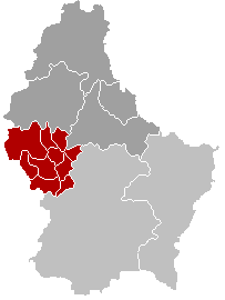
The Canton of Redange is an administrative district in the west of Luxembourg. Its administrative seat is the town of Redange, often called Redange-sur-Attert. The canton lies near the national frontier and is characterized by a mix of small towns, agricultural land and wooded hills. Its approximate central coordinates are noted as 49°48′N 5°48′E.
Image gallery
4 Images


Names and identity
In Luxembourgish the area is known as Réiden. As a canton it forms one of the country's local government layers inside the Grand Duchy of Luxembourg. The canton takes its name from its capital, shown in official contexts as Redange, and frequently referred to by its full traditional name Redange-sur-Attert.
Geography and administration
The terrain includes river valleys — notably the Attert — rolling countryside and patches of forest. The canton contains several communes and municipal centers that range from small market towns to farming villages. Administrative functions are concentrated in the capital, while local services are distributed across the constituent communes.
Economy and culture
Economic activity in the canton is largely rural: mixed farming, local crafts, and small enterprises play an important role. Commuting to larger urban areas is common. Cultural life reflects Luxembourg's multilingual character and local traditions, with community festivals, parish events and preservation of regional architecture.
History and notable facts
The canton developed over centuries as part of Luxembourg's territorial organization, shaped by its border location and agricultural base. Its rivers and road links have historically influenced settlement patterns. Today it is valued for its scenic landscapes and as a quieter residential region with ties to neighboring areas across the border.
- Location note: central coordinates shown above for reference.
- Character: primarily rural, with small urban centers.
- Administration: capital at Redange-sur-Attert.
Questions and answers
Q: What are the coordinates of Redange?
A: The coordinates of Redange are 49°48′N 5°48′E / 49.800°N 5.800°E / 49.800; 5.800.
Q: What is the capital of Redange?
A: The capital of Redange is Redange, also called as Redange-sur-Attert.
Q: In which country is the canton of Redange located?
A: The canton of Redange is located in Luxembourg.
Q: How do you say "Redange" in Luxembourgish?
A: In Luxembourgish, "Redange" is said as "Réiden".
Q: What type of geographical area is the canton of Redange?
A: The canton of Redange is a canton, which is an administrative division or subnational entity within a country or state.
Q: Is there any other name for the capital city of this canton?
A: Yes, the capital city of this canton has another name - it's called as "Redange-sur-Attert".
Related articles
Author
AlegsaOnline.com Canton of Redange — western Luxembourg canton overview Leandro Alegsa
URL: https://en.alegsaonline.com/art/81720
Sources
- commons.wikimedia.org : Canton of Redange
- statistiques.public.lu : "Surface area of the cantons and municipalities"
- statistiques.public.lu : "Population by canton and municipality 1821 - 2017"
- legilux.public.lu : "Mémorial A, 1978, No. 46"