Quebec City
Québec (French [kebɛk] ![]() ) or Quebec (English [kɨˈbɛk]), also called Ville de Québec or Quebec City for better distinction, is a major city in eastern Canada. The capital of the province of Quebec of the same name, it is located on the north bank of the Saint Lawrence River, at the mouth of the Rivière Saint-Charles and before the beginning of the Saint Lawrence Estuary. Its distinctive geographical features are the striking narrowing of the stream, which gave the city its name, and the Colline de Québec plateau, which rises steeply above the stream for about a hundred metres and on which the city centre is located.
) or Quebec (English [kɨˈbɛk]), also called Ville de Québec or Quebec City for better distinction, is a major city in eastern Canada. The capital of the province of Quebec of the same name, it is located on the north bank of the Saint Lawrence River, at the mouth of the Rivière Saint-Charles and before the beginning of the Saint Lawrence Estuary. Its distinctive geographical features are the striking narrowing of the stream, which gave the city its name, and the Colline de Québec plateau, which rises steeply above the stream for about a hundred metres and on which the city centre is located.
Originally, the Saint Lawrence Iroquois lived here in the village of Stadacona. In 1543, a first French colonization attempt led by Jacques Cartier failed. On July 3, 1608, the navigator Samuel de Champlain founded a trading post from which the later city developed. Three years after the conquest by English adventurers, Québec returned to French possession in 1632. Further English or British attempts at conquest in 1690 and 1711 failed. In 1759, the British finally succeeded in taking the city after a two-and-a-half month siege and the Battle of Abraham Plain. In 1867, Quebec became a provincial capital in the new Canadian state. In the second half of the 19th century, the city lost its status as a leading economic centre to Montreal and stagnated for several decades. During the 20th century, Québec emerged as the undisputed centre of the eastern part of the province.
Architecturally, Québec is considered the most European city in North America, due to its well-preserved old town with numerous buildings of predominantly French design dating back to the 17th century. The upper part of the old town is surrounded by city walls, which are supplemented by a citadel. Québec is today the only fortified city in the Americas north of Mexico. In 1985, UNESCO declared the old town and fortifications a World Heritage Site.
With 531,902 inhabitants (2016), Québec is the second largest city in the province and the eleventh largest in Canada. It achieved this status in 2002, when the population tripled due to the incorporation of several suburbs. 93.8% of the population is French-speaking. The metropolitan region Communauté métropolitaine de Québec, which includes the city of Lévis south of the Saint Lawrence River, has a population of 812,205 (2017). The economy is dominated by the service sector, with an above-average representation of public administration. Tourism is also of great importance. Industry is focused on research-intensive cutting-edge technology; the formerly dominant wood-processing industry now plays only a marginal role.
Geography
Location
The city is located in the south of the province named after it, Québec, about 120 kilometres northwest of the border with the US state of Maine. Montreal is 233 kilometres away to the southwest, the federal capital Ottawa 378 kilometres to the west-southwest. Boston is 498 kilometres to the south and Halifax 644 kilometres to the east-southeast.
Waters
Québec is located on the north bank of the Saint Lawrence River, the third largest river in North America (measured by discharge). The stream is two and a half to three kilometres wide above the city and narrows to just over a kilometre around the city centre. It then divides into two arms, which surround the Île d'Orléans. After this island, the Saint Lawrence estuary begins, which is over 350 km long and up to 60 km wide. Because the channel greatly increases the flow velocity and the tides are still noticeable (1.8 to 3.1 m difference between low and high tide) due to the small difference in altitude with the Atlantic Ocean, the Québec Narrows is a challenging place for navigation.
The most important tributary is the Rivière Saint-Charles, which lies entirely within the city limits. It rises in Lac Saint-Charles on the northern outskirts of the city, meanders strongly, especially in its upper reaches, towards the southeast and flows into the Saint Lawrence River after 35 kilometres. Its catchment area, which includes several other rivers, is the most densely populated in the province of Québec. A small part of the urban area in the far northwest is part of the catchment area of the Rivière Jacques-Cartier. The lower reaches of the Rivière Montmorency form the city's eastern boundary, and the southwest of the city is drained by the Rivière du Cap Rouge and Lac Saint-Augustin. There are a total of 230 still waters and 695 km of flowing waters in the 454.1 km² urban area.
Topography and geology
Three geological regions almost meet on the city's territory and are only a few kilometres apart. Along the north bank of the Saint Lawrence River rises the Colline de Québec. This plateau, 13 kilometres long and one to four kilometres wide, was crucial to the city's formation and development. It extends from Cap Rouge in the west to Cap Diamant near the mouth of the Rivière Saint-Charles. The plateau, which reaches a height of 110 metres (about a hundred metres above the surrounding terrain), is bordered by rocky slopes that drop steeply, especially towards the stream. The Colline de Québec is one of the few Appalachian foothills north of the stream. The base is composed of sandstone and mudstone, and slate is found on the rocky outcrops.
The broad, shallow valley of the Rivière Saint-Charles, together with the adjacent terraces of Charlesbourg and Beauport, is part of the Saint Lawrence lowlands. Sedimentary layers up to 60 metres thick have been deposited there - mainly sand and gravel, with occasional peat. About 11,500 to 9800 years ago, during the final phase of the last cold period, the lowlands were below sea level in the Champlain Sea. This shallow inlet of the Atlantic Ocean disappeared due to progressive postglacial land uplift. During this process, large quantities of sediments were deposited and islands were initially formed (including the Colline de Québec). About 9000 years ago, a freshwater lake took the place of the Sea of Champlain, Lac Lampsilis. This existed for about 2300 years, giving way to the forerunner of the Saint Lawrence River. For about 3000 years, the stream has roughly corresponded to its present shape.
In the northern third of the city area are foothills of the Laurentian Mountains. They are part of the Canadian Shield, a vast area of very old igneous rocks. The Laurentian Mountains are highly eroded remnants of the Grenville Mountain Formation, which occurred during the Mesoproterozoic, about 1 to 1.6 billion years ago. Predominant is anorthosite interbedded with feldspar. This dark rock is covered by gravel and sand deposits, a legacy of glaciations. The highest point of the town is the 485-metre-high Mont Bélair. A striking stratification marks the transition between the Canadian Shield and the Saint Lawrence lowlands. The Rivière Saint-Charles, for example, pours over the 28-metre-high Kabir Kouba waterfall (Chute Kabir Kouba). To the far east, where the Escarpment almost reaches the Saint Lawrence, the Rivière Montmorency overcomes the 83-metre Montmorency Falls (Chute Montmorency), the highest waterfall in the province.
Neighboring communities
Neighbouring municipalities are Saint-Augustin-de-Desmaures and Sainte-Catherine-de-la-Jacques-Cartier to the west, Shannon and Saint-Gabriel-de-Valcartier to the northwest, Stoneham-et-Tewkesbury, Lac-Delage and Lac-Beauport to the north, and Sainte-Brigitte-de-Laval and Boischatel to the northeast. On the opposite side of the Saint Lawrence River, to the south, is the city of Lévis. Within the city limits, there are three enclaves: the town of L'Ancienne-Lorette, the community of Notre-Dame-des-Anges, which covers only four hectares, and Wendake (an Indian reserve of the Wyandot).
Climate
Québec has a boreal, humid continental climate, which corresponds to the effective climate classification Dfb. Due to its proximity to the ocean, the maritime climate also exerts some influence. Summers are short and hot and humid, with an average maximum temperature of 25 °C (77 °F). On some days, temperatures can rise well above 30 degrees Celsius, with relatively high humidity throughout. Winter is characterised by very cold, snowy and windy weather, with prolonged periods of frost below -20 °C. Spring and autumn are mild, but there can be large fluctuations in temperature. The annual rainfall is about 1190 mm. From November to April, the average snowfall is about 303 cm, with 110 days with a snow cover of more than 20 cm. The annual sunshine duration is 1916 hours. The lowest temperature ever recorded was -36.1 °C on February 2, 1962, and the highest was 35.6 °C on July 17, 1953. The largest amount of rain in one day was 81.2 mm on September 14, 1979, and the largest amount of new snow was 52 cm on December 15, 2003. The Saint Lawrence River usually freezes over from mid-December to late March (in extreme cases from late November to early May), so river navigation must be maintained with icebreakers.
| Quebec | ||||||||||||||||||||||||||||||||||||||||||||||||
| Climate diagram | ||||||||||||||||||||||||||||||||||||||||||||||||
| ||||||||||||||||||||||||||||||||||||||||||||||||
| Monthly average temperatures and precipitation for Québec
Source: Canadian Climate Normals 1981-2010: Aéroport international Jean-Lesage | |||||||||||||||||||||||||||||||||||||||||||||||||||||||||||||||||||||||||||||||||||||||||||||||||||||||||||||||||||||||||||||||||||||||||||||||||||||||||||||||||||||||||||||||||||||||||||||||||||||||||||||||||||||||||||||||||||||||||||||||||||||||||||||||||||||||||||
fauna and flora
Just over 35% of the city is forested, with forests predominantly covering the northern portion located on the Canadian Shield. Prior to European settlement, there were few non-forested areas. The original vegetation varied according to soil and climatic conditions, generally with deciduous forest in the south and coniferous forest in the north. On the Colline de Québec, sugar maples predominated, along with lime, beech, and elm. Red maples were found on lower, wetter sites, and red oaks and Weymouth pines on drier sites. Along the Rivière Saint-Charles there were mainly birch forests, interspersed with various other deciduous trees. To the north, pine forests still predominate, with occasional yellow birch. In total, there are 30 nature and landscape reserves in the city.
Because forests are often immediately adjacent to residential areas, numerous animal species have adapted to life in urban environments. The most common mammal species include gray squirrels, red squirrels, chipmunks, striped skunks, tree sparrows, muskrats, raccoons, mink, woodchucks, red foxes, snowshoe hares, moose, white-tailed deer, and various New World mice. Occasional sightings include wolves and coyotes, as well as black bears. The herpetofauna (the totality of amphibians and reptiles) has low biodiversity and is severely threatened by urbanization and agriculture and forestry. In total, only 20 different species are counted. In contrast, the avifauna (totality of bird species) is characterised by a great diversity due to the different habitats. Although no systematic inventory exists, at least 324 species have been recorded to date. The Saint Lawrence Current in particular has a diverse ichthyofauna: Up to 71 fish species occur, with cod, perch, pike and sucker carp being the most common. Diversity in the tributaries is significantly lower.
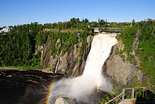
Montmorency Falls
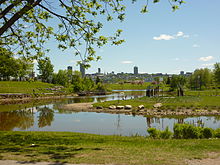
Urban park landscape on the Rivière Saint-Charles
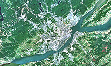
Satellite photo with Québec and Lévis
History
Name origin
The city's name comes from the narrowing of the river between Québec and the opposite Lévis. In the Algonkin language, the word Kebec means "where the river narrows". The Algonkin themselves have always referred to the town as Kephek, and the Mi'kmaq who live further east as Gepeg, the latter of which can also be translated as "bottleneck". According to a less common theory, kepek is said to have been a request from the Innu living north of this area for Samuel de Champlain to step down from his ship.
While the name Québec quickly caught on, over the years there were two serious proposals for another city name. Champlain himself suggested in 1618 that the city be called Ludovica in honour of the French King Louis XIII. After the creation of the Canadian Confederation in 1867, the problem was that the new province of Québec was named the same as the city. To avoid confusion, the city was to be named Stadacona (after an earlier aboriginal settlement). Submissions to this effect were unsuccessful.
Several variant spellings can be found in older documents: Quebecq (1601), Kébec (1609), Quebec (1613). The designation of the city's inhabitants also took different forms: Kébécois (1935), Québeccois (1835), Quebecois (1754), Québécois (1775), Québecquois (1825), Québécuois (1910), Quebequois (1754), and also Stadaconien. In French, the distinction between city and province is made by prefixing the latter with the definite article le.
Early history and discovery
The oldest traces of human settlement are found in the Place Royale area of the Lower Town. Stone tools discovered there are around 5000 years old and date from the Archaic period and the early Woodland period. The tools were made by local hunters, gatherers and fishermen from locally available stone. Also in the Archaic period, about 4000 years ago, people settled on the eastern shore of Lac Saint-Charles.
Under the Place Royale, pottery from the Woodland period was found, dating from about 2400 to 450 years ago. Around 500 AD, the regions around Québec and Montreal began to develop different styles of pottery, which is considered to indicate groups or tribes with different identities. Finds of pipe bowls (and thus the production of tobacco) point in a similar direction, namely ethnic differentiation and increasing agriculture. These pipe bowls were rare before 700, but later common and widespread. The northeastern part of the later upper town may have been settled from the mid-14th to the mid-16th century.
In 1534, the French navigator Jacques Cartier was commissioned by King François I to find a northwest passage to Asia. His first expedition took him as far as the island of Anticosti, but he did not venture further into the Saint Lawrence estuary. He sailed up the stream with a second expedition in 1535, reaching what is now the city on September 7, and discovered the village of Stadacona, a Saint Lawrence Iroquois settlement of about 500 inhabitants, on the lower reaches of the Rivière Saint-Charles. After an exploratory voyage upstream to Île de Montréal, Cartier wintered in Stadacona. When he returned to Europe in May 1535, he had the Iroquois ruler Donnacona kidnapped, who died four years later in France.
In 1541, the king commissioned the courtier Jean-François de La Rocque de Roberval to build a colony. La Roque entrusted Cartier with the execution of the plan. The latter's third expedition was not only to establish a permanent French presence in the NewWorld, but also to find the fabled kingdom of Saguenay. Some 350 colonists arrived at Stadacona in August 1541. Due to hostilities, they sailed several miles upstream and established the settlement of Charlesbourg-Royal at Cap Rouge. Raids by the Saint Lawrence Iroquois, a severe winter, and scurvy plagued the colonists. In June 1542, disillusioned, they returned to France. A second group of 200 settlers under La Roque's command had left for Charlesbourg-Royal two months earlier and arrived there in July. The problems continued unabated, so the settlement was finally abandoned in the spring of 1543.
French Colonial Period
Champlain undertook a reconnaissance in 1603, following Cartier's footsteps. The village of Stadacona could no longer be found and the Saint Lawrence Iroquois had disappeared without a trace. Apart from nomadic Algonkin and Innu, the Saint Lawrence lowlands were largely uninhabited. The disappearance of the original population has been blamed on conflicts with neighboring Iroquois tribes, effects of epidemics introduced by Europeans, such as Basque fishermen, or a migration movement toward the Great Lakes. The former was considered most likely, but the processes behind it remain unclear. Archaeologically, seven distinguishable groups can be identified along the Saint Lawrence River. Among these, the Québec group was engaged in long-distance trade, which brought them into possession of the products of the hunters of beluga whales and seals on the Atlantic coast. In addition, the Québec Iroquois differed from the rest in that they did not develop a sedentary horticultural culture, but instead used the estuary in seasonal migrations. In doing so, they developed a common way of life with Algonkin groups.
Also in 1603, Pierre Dugua de Mons was granted a trading monopoly in New France by King Henri IV, with the fur trade in particular promising great profit. He lost his monopoly in 1607 due to complaints from rival merchants, but regained it a year later after pledging to establish a trading post on the St. Lawrence River. The founding date of Quebec City is July 3, 1608, when Champlain landed at Cap Diamant on De Monts' behalf and craftsmen and workmen began to erect the Habitation de Québec at what is now Place Royale. This "habitation" served as a dwelling, fort, and trading post. Only eight of 28 expedition members, including Champlain, survived the first winter. Gradually, the situation stabilized and a small influx of colonists began. In 1620, the first building on the plateau was built, the Château Saint-Louis.
In 1627, under the chairmanship of Cardinal Richelieu, the Compagnie de la Nouvelle France was founded, a state-privileged trading company with an unlimited monopoly on the fur trade. Even before its associates could begin to bring 4000 settlers to New France in accordance with the contract, France and England had gone to war with each other as part of the Thirty Years' War. An expedition of the adventurer David Kirke captured Québec on July 19, 1629. With the exception of the family of the first settler, Louis Hébert, the French inhabitants left the settlement; their number had been only 85 in 1627, all men. The conquest had occurred three months after the signing of a peace treaty, so France insisted on restitution. This was agreed in 1632 in the Treaty of Saint-Germain-en-Laye. Catholicism exerted a great influence on society at an early date. In 1615 the first Franciscan missionaries arrived in Québec; Jesuits followed in 1625, and Ursulines and Augustinian nuns in 1639. While the social elite and religious communities settled in the upper town, merchants, sailors and craftsmen populated the lower town.
The Compagnie had only moderate success in the economic development and colonization of New France, moreover, the territory was poorly secured militarily. King Louis XIV declared the colony a province in 1663 and placed it directly under the Crown. He designated Québec as the capital and restructured the administration. At the time, the city had only a little over 500 inhabitants (almost a quarter of whom were clergymen), and there was also a great imbalance between the sexes. To stimulate population growth, the king financed the passage and dowry of young single women from poor backgrounds. Between 1663 and 1673, some 800 "daughters of the king" (filles du Roi) arrived in Québec in this way. In 1665, the King sent 1200 men of the Carignan-Salières regiment to eliminate the threat of Iroquois raids in the Beaver Wars. At the conclusion of the campaign, over a third of the soldiers settled here. The immigrants came mainly from the north and west of France, more precisely from the provinces of Normandy, Île-de-France, Aunis, Poitou, Perche and Saintonge.
Trade was restricted by law to France and other French colonies. New France therefore had a constantly negative trade balance. This resulted in a chronic shortage of cash for decades, so that from 1685 playing cards were temporarily in circulation as a substitute currency. In 1688, King William's War broke out, pitting the French and the Wabanaki Confederacy against the English and Iroquois. In response to incursions in New England, an English fleet under the command of William Phips sailed to Quebec in the fall of 1690 to capture the city. After Governor Louis de Buade de Frontenac rejected the surrender demand on October 16, French troops and militia managed to rout the English in the Battle of Québec after eight days. In the next of the "French and Indian Wars", Queen Anne's War, a fleet again attempted to capture the city. The British Quebec Expedition ended in disaster on August 22, 1711, when eight ships capsized in the St. Lawrence River; 890 soldiers and sailors were killed. From 1693 a system of walls and ramparts was built around the city, but in 1721 the government decided against developing the partially isolated fortifications into a proper fortified city. The destruction of Louisbourg during King George's War caused great anxiety among the population in 1745. Immediately the governor ordered the completion of the fortifications. The Chemin du Roy, completed in 1737, enabled a more intensive exchange of goods with Montreal, as the Saint Lawrence River, which froze over in winter, was no longer an obstacle.
British rule
Five years after the outbreak of the Seven Years' War in North America, a British force of 168 ships sailed up the Saint Lawrence River in June 1759. The siege of Quebec began on June 26 and lasted over two and a half months. The French repulsed a first attempt at storming on July 31 at the Battle of Beauport. The decisive battle on the Plains of Abraham on 13 September ended in a British victory and enabled the siege ring to be closed, after which the French garrison surrendered five days later. Both commanders-in-chief, James Wolfe and Louis-Joseph de Montcalm, did not survive the battle. Seven months later, French troops from Montreal attempted to retake Quebec. Although they were victorious at the Battle of Sainte-Foy on April 28, 1760, they were unable to take the city. They retreated to Montreal, where they eventually succumbed to British superiority. With the Peace of Paris in 1763, New France finally passed into British possession. Québec became the capital of the new British province of Québec and the most important administrative centre of British North America.
Despite heavy destruction from artillery fire, the city quickly recovered from the consequences of the war. Fearing revolts and a reconquest by France, the British repaired the fortifications. For financial reasons, they initially refrained from expanding them. The Quebec Act, which came into force in 1774, guaranteed religious freedom and restored French private law. In this way, the British secured the loyalty of the great landowners and the clergy. This act was one of the Intolerable Acts ("intolerable laws") that increased unrest in the southern Thirteen Colonies and contributed to the outbreak of the American War of Independence there the following year. In the early months of the conflict, the Continental Army attempted to drive the British from the province of Québec and win French Canadians to the Revolution with a push north. At the Battle of Quebec on December 31, 1775, American troops under Richard Montgomery and Benedict Arnold entered the lower city but were repulsed. They broke off the subsequent siege without result in May 1776.
Even after the British conquest, Québec remained an important trading city, although many French wholesalers left. They were increasingly replaced by the British, who benefited from a much larger trading network. They took control of the fur trade, fishing, shipbuilding, and troop supply, while French Canadians were relegated to intermediate and retail trade. The lumber industry initially played a minor role, as Britain met its lumber needs through imports from the Baltic region. In 1806 the situation changed abruptly when Napoleon Bonaparte imposed the Continental Blockade. A decade-long boom set in, which continued unabated after the end of the Coalition Wars thanks to advantageous customs tariffs. Most of the lumber exported from Québec came from the Outaouais region and was transported here by raftsmen. For a time, Québec was the third largest port in North America behind New York and New Orleans. The export of lumber also stimulated shipbuilding: At its peak around 1860, 28 shipyards were in operation, building sailing vessels of all kinds. In addition, there were numerous suppliers such as sailmakers or ropemakers.
Between 1786 and 1812, the fortifications were further strengthened, including the addition of four Martello towers. The last and most important element was the Citadel of Québec, built between 1820 and 1832. After its completion, the military claimed about a quarter of the city's area for itself, the garrison was between 1000 and 1500 men strong. By the mid-19th century, the installations were considered disruptive to the city's expansion, especially since they were by then considered technically obsolete. In the Romantic era, however, it was the medieval-looking town complex, nestled in the surrounding natural beauty, that attracted numerous travellers from Europe and the USA from the 1820s onwards. In 1842, Charles Dickens described Québec as "the Gibraltar of America" in his Notes from America. Contrast this with the privations of the inhabitants. The numerous immigrants passing through repeatedly brought in epidemics; in 1832 alone, 3292 people died of cholera. Inadequate building regulations in the suburbs encouraged major fires: on 28 May 1845 some 1600 houses were destroyed in the Faubourg Saint-Roch, and a month later a further 1300 in the Faubourg Saint-Jean; more than 20,000 people were temporarily homeless.
During the French colonial period, there had been no independent city administration, the administration was carried out directly by the colonial authorities. After the conquest, the city was initially under military administration for five years. From 1764 onwards, justices of the peace appointed by the governor were responsible for municipal affairs. Although they were able to expand their powers over time, this simple administrative structure soon became inadequate for the rapidly growing city and complaints were frequent. Finally, in 1833, Quebec was granted a charter (municipal code) and an elected mayor. The governor temporarily repealed the charter three years later and reinstated it in 1840. From 1791, Québec was the capital of the British colony of Lower Canada. In the province of Canada, created in 1841, the capitals changed several times; Québec held this status from 1852 to 1856 and from 1859 to 1866.
Canadian provincial capital
In October 1864, the Quebec Conference took place, where delegates from several colonies negotiated the future of British North America. They agreed to form the Canadian Confederation. As of July 1, 1867, Quebec was the capital of the province of the same name within the new Canadian Confederation. The parliaments of Lower Canada and the Province of Canada had once met in the former Bishop's Palace until it burned down in 1854. The building that was built to replace it did not meet the requirements, as it was also used as a post office. Therefore, the representative Hôtel du Parlement was built between 1877 and 1886. Another important event was the withdrawal of the British garrison in 1871. Before that, several city gates had been demolished to improve the flow of traffic. A committee led by Governor General Lord Dufferin successfully campaigned for the preservation of the historically significant city walls and the rebuilding of two gates. The last significant major fire occurred in 1889 in the Faubourg Saint-Sauveur, destroying some 500 houses. In the same year, boulders from Cap Diamant fell on the lower town; the Québec landslide claimed 45 lives.
Compared to Montreal, which developed into the economic metropolis of Canada, Québec quickly fell behind from the middle of the 19th century. There were many reasons for the decades of stagnation. Exports of unprocessed raw lumber declined in favour of lumber produced elsewhere. Trade flows increasingly shifted toward the U.S. and western Canada, favouring Montreal and Toronto. Technological advances caused the local shipbuilding industry to collapse completely in the 1870s: Wooden sailing ships were no longer in demand and were supplanted by ships with metal hulls. The port was also no longer competitive, as the dredging of a channel in the St. Lawrence River allowed ocean-going ships to sail past Québec to Montreal. Connection to the railway network was a long time coming. The Grand Trunk Railway, opened in 1855, ran along the south shore, so goods and passengers had to be ferried to and from Lévis. It was not until February 11, 1879, that a line opened along the north bank of the St. Lawrence River to Quebec. The city had to be content with becoming a regional centre for the east of the province.
At the turn of the 20th century, the upswing began again. On the one hand, this development was favoured by several incorporations, which gave the town room to expand. On the other hand, new industries with thousands of jobs had settled. These included the shoe industry, the textile and clothing industry, the tobacco industry, the paper industry, breweries and the manufacture of munitions. The largest employer was the underwear manufacturer Dominion Corset with over 1000 employees. The railroad network was focused on the northern hinterland, and a direct link to markets in the United States was still lacking. In 1903, construction began on the Quebec Bridge across the St. Lawrence River. The project, financed by the federal government, was ill-starred. Due to serious planning errors, the nearly completed bridge collapsed completely in 1907, killing 76 workers. An installation error caused the middle section to collapse in 1916, claiming 13 lives. It was not until 1919 that the bridge could be opened to rail traffic, and ten years later also to road traffic.
A new landmark in Québec was the Château Frontenac. Opened in 1893, this Canadian Pacific Railway hotel was instrumental in the city's development as a major tourist destination. Shortly after the outbreak of the First World War, the Valcartier military base for 25,000 recruits was established near the city in September 1914. During a demonstration against the introduction of conscription, which was controversial among francophones, four people died on April 1, 1918, when soldiers fired into the crowd. In Quebec City alone, 500 people died of Spanish flu at the end of the war. The city government was emphatically progressive in the 1920s, demolishing numerous buildings to make way for wider streets and modern new buildings. This approach was particularly striking when the Price Brothers paper company was allowed to build its headquarters, the Édifice Price, in the middle of the old town between 1929 and 1931. Political resistance arose against the endangerment of the architectural heritage, which gradually brought about a change of heart.
The world economic crisis that began in 1929 hit industry hard, and the city administration reacted to the sharp rise in unemployment with job creation measures. The situation did not ease until the beginning of the Second World War, when armaments production caused a surge in employment. In August 1943, the Quadrant Conference was held in Quebec. William Lyon Mackenzie King and Winston Churchill, the prime ministers of Britain and Canada, and U.S. President Franklin D. Roosevelt discussed the surrender of Italy and plans for Operation Overlord. In September 1944, they met for the Second Québec Conference. In October 1945, the FAO was established in Québec. The mayor then had the idea that his city should apply to become the headquarters of the United Nations - an ultimately unsuccessful venture.
Development into a modern metropolis
In the decades following the Second World War, the capital region experienced a rapid boom, caused by the baby boom and by a final surge of industrialisation. The core city grew only slowly due to a lack of expansion opportunities and even showed declining population figures from the 1970s onwards, while the previously rural suburban communities experienced rapid suburbanisation. The striking expansion of the settlement area within a few years entailed a high rate of automobile use. Between 1960 and 1976, a dense network of urban highways emerged. At the end of the 1960s, urban planners assumed that the Québec agglomeration would have a million inhabitants by the turn of the millennium and that a highway tunnel under the old city would be essential to cope with the additional traffic. After just under a hundred metres had been bored, the project was halted in 1976 for financial reasons. For three decades, unused access ramps stood on the north slope of the Colline de Québec until they were demolished in 2007. Université Laval moved from downtown to a sprawling campus in the suburb of Sainte-Foy. Retail trade increasingly shifted to large shopping centres.
During the Quiet Revolution of the 1960s, a fundamental social change took place. The Quebec provincial government secularized education and health care, which had previously been controlled by the Roman Catholic Church. In addition, several sectors of the economy were nationalized. The numerous new functions of the state led to a marked increase in the size of the civil service. As there was a lack of suitable premises, a new representative government quarter was built. Because of its exposed location near the highest point of the Colline de Québec, it symbolized the state's new self-image. Deindustrialization, as well as government austerity measures that halted the growth of public administration beginning in the 1980s, required a reorientation toward the knowledge economy. In April 2001, Quebec was the site of the third Summit of the Americas, whose main theme was a proposed Free Trade Area of the Americas. Over 20,000 anti-globalization protesters protested the summit for days, attempting to break through the more than three-kilometre-long security fence around the meeting site in the old city. An investigative report two years later accused the police of using excessive force against the demonstrators.
Incorporations
Until the end of the 19th century, the urban area was limited to the old town and immediately adjacent suburbs. The first commune to be incorporated was Saint-Sauveur in 1889. It was followed by Saint-Malo (1908), Limoilou (1909) and Montcalm (1913). Québec thus encompassed an area roughly equivalent to today's central borough of La Cité-Limoilou. It took more than five decades before the next expansion. In 1970, Duberger and Les Saules were incorporated. In 1971 Neufchâtel was added, and in 1973 Charlesbourg-Ouest. These communes roughly correspond to the municipality of Les Rivières.
In 2001, the provincial government led by the Parti Québécois decided on numerous municipal mergers; for example, the provincial capital was to be merged with twelve suburban municipalities. Despite strong political opposition, the government ordered the merger of Québec with Beauport, Cap-Rouge, Charlesbourg, L'Ancienne-Lorette, Lac-Saint-Charles, Loretteville, Saint-Augustin-de-Desmaures, Saint-Émile, Sainte-Foy, Sillery, Val-Bélair and Vanier as of January 1, 2002. The Parti libéral du Québec won the provincial election in April 2003. One of its election promises was to put the mergers to a referendum after the fact. However, the new government set conditions that were difficult to meet. First, one-tenth of all registered voters had to sign a petition to bring about a vote. Second, at least 35% of all registered voters had to approve (so a simple majority was not enough for secession). Referenda were held in all former municipalities on July 20, 2004. Six approved secession from Québec, but only L'Ancienne-Lorette and Saint-Augustin-de-Desmaures reached the necessary quorum. These municipalities were re-established on January 1, 2006, but had to cede some of their former powers to the federation of municipalities.
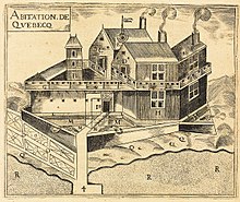
Habitation de Québec, drawn by Samuel de Champlain (1608)
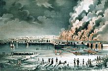
Great fire in the Faubourg Saint-Roch (28 June 1845)
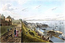
Walkers in the upper town looking towards the harbour (1833)
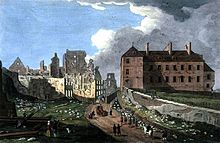
Ruins next to the bishop's palace after the conquest (1759)
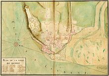
City map (1727)
.jpg)
Québec in 1700
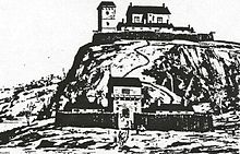
Sketch of Charlesbourg-Royal from the year 1542
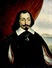
Champlain as he was imagined around 1870
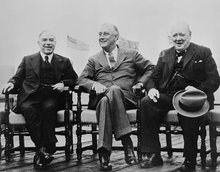
Quadrant Conference 1943; from left to right: William Lyon Mackenzie King, Franklin D. Roosevelt, Winston Churchill
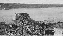
Collapse of the Québec Bridge, 1907
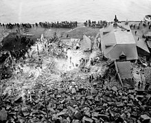
Landslide in the lower town, 1889
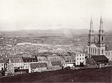
View from the upper town into the valley of the Rivière Saint-Charles (1858)
Search within the encyclopedia