Punjab
![]()
This article is about the former province of Punjab in British India, for other meanings see Punjab (disambiguation).
The Punjab, in German Punjab (also Pundschab), was the name for a former province in British India from 1849 to 1947. In 1947, the area was divided between the now independent states of Pakistan (Punjab Province) and the Indian Union (Punjab State). The name Punjab (Punjabi: ਪੰਜਾਬ panjab pañjāb) is derived from Persian پنجاب pandschāb, DMG panǧāb, 'five-stream land' (from پنج pandsch, DMG panǧ, 'five' and آب, DMG āb, 'water').

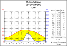
Climate diagram Multan

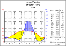
Climate diagram Lahore

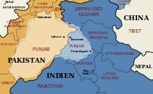
Map of Punjab against the background of the present borders
_with_cities.png)
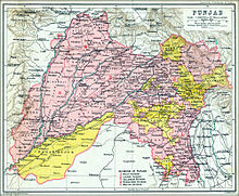
Topographical map of the Punjab, from which the designation "five-stream country" becomes clear

The Punjab in 1909. The territory directly administered by the British is marked in pink, the princely states in yellow.
Geography
Geographically, Punjab refers to the wedge-shaped southwestern converging flood plain of the five left bank Indus tributaries Jhelam, Chanab, Ravi, Beas and Satluj. The western boundary of Punjab is formed by the Suleiman Mountains on the border with Afghanistan. To the north the Salt Range and the Himalayas, to the south the Thar Desert and to the east a low watershed to the Gangetic lowlands border Punjab. The Punjab area is formed mainly by extremely fertile Quaternary alluvial fans lying 10 to 15 m above the valley bottoms. It is the largest closed irrigation area on earth, with an irrigated area of 102,000 km², almost four times the irrigated area of the Nile (26,000 km²).
Traditionally, only the areas in the immediate vicinity of the rivers were irrigated in early summer by channeling the high water of the summer monsoon onto the fields. During the British colonial rule, the construction of dams and canals made it possible to use higher-lying areas for agriculture by year-round irrigation and to obtain several harvests a year.
Water Use
In 1960, India and Pakistan regulated water use in Punjab in the Indus Water Treaty. According to this treaty, India is allowed to divert the headwaters of the Ravi, Satluj and Beas rivers to its territory, but in return must ensure that Pakistan has access to the water of the Indus, Chanab and Jhelam rivers. To enable year-round irrigation on the one hand and to prevent flooding during the summer monsoon on the other, further dams and canals have been built.
The expansion of irrigated land had serious ecological consequences. Due to the year-round water supply, the groundwater level rose sharply and extensive areas became swampy. In the southern part of the Punjab, the high temperatures and the resulting high evaporation with low rainfall (see climate diagram Multan) lead to salinization of the soils. Attempts are being made to solve this problem by digging wells up to 100 m deep and pumping out the groundwater.
Search within the encyclopedia