Punakha District (Bhutan)
Punakha District is a historic and fertile district in western Bhutan, known for Punakha Dzong, river valleys, agriculture, and parts of Jigme Dorji National Park. The administrative centre is Punakha town.
Overview
Punakha District lies in western Bhutan; its map coordinates place it among the country's river valleys. It is one of the 20 administrative districts of Bhutan, and its administrative centre is Punakha town. The district combines significant cultural landmarks, productive farmland and protected mountain environments.
Image gallery
8 Images


Geography and environment
Punakha occupies a lower-altitude valley carved by major rivers, with subtropical and temperate zones as elevation rises toward the north. The valley floor is irrigated and fertile, and the confluence of two rivers contributes to its historical importance. Higher slopes lead into forested foothills and alpine terrain that forms part of important conservation areas.
History and cultural importance
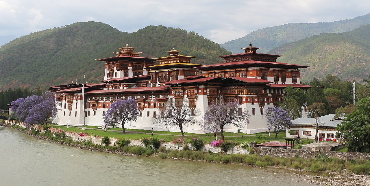
Historically Punakha has been central to the formation of modern Bhutan. The district contains the famed Punakha Dzong, an ornate fortress-monastery built in the 17th century by Zhabdrung Ngawang Namgyal. For centuries the dzong served as a seat of government and a winter residence for the central monastic body. It remains the site of major religious festivals and state ceremonies.
Administration and protected areas
The district is subdivided into eleven village blocks (gewogs), the basic units of local government that manage rural administration and services. Parts of Jigme Dorji National Park fall within the district boundary, linking Punakha to one of Bhutan's largest conservation reserves and contributing to regional biodiversity and watershed protection.
Economy, tourism and risks
Agriculture is an economic backbone: rice paddies and irrigated crops flourish on the valley floor, while horticulture and livestock are common at higher elevations. Cultural tourism centered on Punakha Dzong, seasonal festivals and outdoor activities such as river excursions and treks draw visitors. The district also faces environmental challenges common to Himalayan valleys, including seasonal floods and the long-term impacts of changing mountain hydrology.
Notable facts
- Punakha is recognized for its historic dzong architecture and national ceremonies.
- The combination of lowland agriculture and nearby alpine conservation makes it ecologically diverse.
- Administrative organization into eleven gewogs supports localized governance and rural development.
For visitors and scholars alike, Punakha offers a compact view of Bhutan's cultural history, living religious traditions and a working agricultural landscape set against protected mountain terrain.
Questions and answers
Q: How many districts does Bhutan have?
A: Bhutan has 20 districts.
Q: Where is the administrative center of Punakha District located?
A: The administrative center of Punakha District is located in Punakha.
Q: What is the name of the national park in Punakha District?
A: The name of the national park in Punakha District is Jigme Dorji National Park.
Q: How many village blocks are there in Punakha District?
A: There are eleven village blocks in Punakha District.
Q: What are the coordinates of Punakha District?
A: The coordinates of Punakha District are 27°40′N 89°50′E / 27.667°N 89.833°E / 27.667; 89.833.
Q: What is the significance of Punakha District in Bhutan?
A: Punakha District is one of the 20 districts in Bhutan and is home to the administrative center of Punakha and Jigme Dorji National Park.
Q: How is Punakha District divided?
A: Punakha District is divided into eleven village blocks.
Related articles
Author
AlegsaOnline.com Punakha District (Bhutan) Leandro Alegsa
URL: https://en.alegsaonline.com/art/80048