Po (river, Italy)
Longest river in Italy, flowing east from the Cottian Alps to the Adriatic; vital for the Pianura Padana's ecology, economy, navigation and cultural history.
Overview
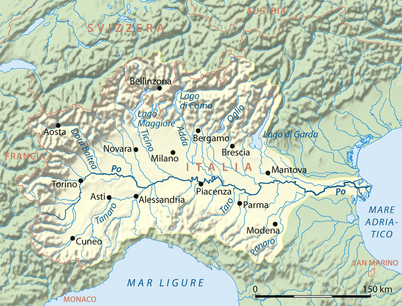
The Po is the longest river in Italy, running about 652 km from its alpine source to the Adriatic Sea. Rising near Monviso in the Cottian Alps, the Po traverses the broad lowland known as the Pianura Padana and drains an area of roughly 71,000 km². In antiquity it was known to Roman writers as Padus and sometimes as Eridanus; in modern Italian it is simply the Po. Its course and floodplain have shaped northern Italian settlement, agriculture and industry for millennia.
Image gallery
8 Images


Course and physical characteristics
The river flows generally eastward across northern Italy, from high alpine terrain to the shallow Adriatic basin. The main source is on the slopes of Monviso; smaller headwaters join as the river descends. The Po empties into the Adriatic Sea in a broad delta north of Venice. Along its route it passes by or near important urban centres, notably Turin, and connects indirectly with Milan through historic canals in Lombardy that were improved in the Renaissance.
Major tributaries contribute much of its flow; among the best known are the Dora Riparia, Dora Baltea, Tanaro, Ticino, Adda, Oglio and several Apennine feeders such as the Secchia and Panaro. The lower Po spreads onto a wide alluvial plain and divides into numerous branches before reaching the sea.
Delta, ecology and notable features
Near its mouth the river forms a complex delta with hundreds of channels and several principal distributaries, historically named Po di Maestra, Po della Pila, Po delle Tolle, Po di Gnocca and Po di Goro. The delta and adjacent wetlands support diverse birdlife, fish and marsh habitats. Parts of the southern delta, including the lagoon and channels around Comacchio, are known for eel fisheries and traditional saltworks; the area has long been prized for its aquatic resources and biodiversity.
Human use, economy and management
The fertile plain through which the Po runs—the Pianura Padana—is Italy's dominant agricultural and industrial region. Intensive cultivation produces cereals, rice, fruit and vegetables, supported by irrigation fed from the river and its canals. Navigation historically linked interior towns; the Milanese canal network (the navigli) was improved during the Renaissance with input credited to engineers including Leonardo da Vinci. Flood control, drainage and water allocation on the Po are managed by national and regional bodies; one specialised institution often cited in this context is the Magistrato delle Acque.
History, culture and hazards
The Po valley has been central to Italy's history since pre-Roman and Roman times, forming the heartland of Roman Cisalpine Gaul and later key medieval and modern states. The river appears in literature and local traditions and has long governed settlement patterns. At the same time the Po has posed recurrent flood risk: levees, canals and basin engineering have reduced some danger but also changed natural habitats and sediment flows.
Environmental concerns and research
Water quality and ecosystem health in the Po have been subjects of scientific study and public debate. Chemical pollutants, agricultural runoff and altered flow regimes affect fish and wetland communities. In the mid-2000s monitoring detected human drug metabolites in the river system, prompting research into wastewater transport and public-health indicators; for example reports noted traces of benzoylecgonine, a metabolite excreted after use of cocaine, found in samples and in human urine studies, which raised concerns about contamination pathways and urban wastewater treatment.
Quick facts and references
- Length: about 652 km
- Drainage basin: ~71,000 km²
- Source: Monviso (Cottian Alps)
- Mouth: Adriatic Sea, delta north of Venice
- Notable towns on or near the river: Turin, and linked cities such as Milan
For further general information see regional river authorities and Italian environmental agencies; historical overviews and ecological assessments provide complementary perspectives on the Po's long role in shaping northern Italy's landscape and society. Additional material on the river's delta and fisheries can be found through resources that focus on wetlands and coastal management (delta, eels).
Questions and answers
Q: What is the Po river?
A: The Po (Latin: Padus, Italian: Po, ancient "Eridanus") is a river that flows 652 kilometers (405 miles) eastward across northern Italy, from Monviso (in the Cottian Alps) to the Adriatic Sea near Venice.
Q: How long is the Po river?
A: The Po has a length of 652 kilometers (405 miles).
Q: What cities does it go through?
A: The Po goes through many important Italian towns, including Turin (Torino) and Milan (Milano), in Lombardy.
Q: What did Leonardo da Vinci help design related to the river?
A: Leonardo da Vinci helped design a net of channels called navigli which are connected to Milan.
Q: What is located at the end of its course?
A: At the end of its course, it creates a wide delta with hundreds of small channels and five main ones called Po di Maestra, Po della Pila, Po delle Tolle, Po di Gnocca and Po di Goro.
Q: What region does it correspond to in Roman times?
A: The vast valley around the River corresponds to Roman Cisalpine Gaul which was divided into Cispadane Gaul (South of the River) and Transpadane Gaul (North of the River).
Q:What substances were found in water from this river in 2005 ?
A:In 2005 water from this River was found to contain "staggering" amounts of benzoylecgonine which is excreted by cocaine users in urine.
Related articles
Author
AlegsaOnline.com Po (river, Italy) Leandro Alegsa
URL: https://en.alegsaonline.com/art/77554
Sources
- commons.wikimedia.org : Po river