Platte River
A broad, shallow river in Nebraska formed by the North and South Platte; important geographically, historically and ecologically as a migratory bird corridor and watering route for westward travelers.
Overview
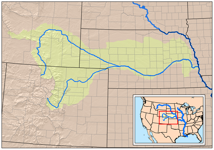
The Platte River is a major waterway in the central United States formed where the North Platte and South Platte rivers meet in western Nebraska. From that confluence it flows generally eastward across the state to join the Missouri River. The river is commonly described as wide, shallow and braided rather than deep and channelized, a character that shaped how people and wildlife used it for centuries. It is sometimes called the Nebraska River in older sources and maps.
Image gallery
9 Images


Physical characteristics
The Platte is notable for its low gradient and its tendency to split into many shallow channels separated by sandbars and islands. These braided channels carry seasonal flows that vary with snowmelt and rainfall, making the river broader and shallower than many similarly long rivers. Although the main stem is about 310 miles long, the full Platte system — including its North and South forks — drains a much larger region of the central Plains and Rocky Mountain front ranges.
History and human use
For Native American peoples the Platte valley provided water, fish and transit. In the 19th century it became a major corridor for overland emigration: the Oregon, California and Mormon Trails followed the river for long stretches because it offered relatively level travel and access to water. Towns and irrigation projects later developed along its banks, and the river has supported agriculture, municipal water supplies and local recreation ever since.
Ecology and wildlife
The Platte's shallow braids and exposed sandbars create habitat that is critical for several bird species. Most famously, the river valley in central Nebraska is a staging area for large numbers of sandhill cranes during spring migration, attracting scientists and birdwatchers. Wetland and riparian zones along the Platte also support waterfowl, wading birds, fish and a variety of native plants. Conservation concerns include altered flow regimes, water withdrawals for irrigation, and habitat fragmentation.
Importance and distinctions
- The river is not navigable for commercial traffic in the way deeper rivers are because of its braided, shallow nature.
- It served as a natural guide and lifeline for 19th‑century emigrant trails crossing the Great Plains.
- Its valley is a key stopover on the Central Flyway for migratory birds, especially sandhill cranes.
For maps and further information about the Platte's course and watershed, see regional resources on the Platte River and general references to the United States river network.
Run
The river is formed in western Nebraska at North Platte by the confluence of its headwaters, the North Platte River and the South Platte River, which rise in the Rocky Mountains of Colorado not far from the Continental Divide. In a wide arc it flows first southeast and then northeast, passing the towns of Gothenburg, Cozad, Kearney, and Grand Island on its way. Five miles southeast of Columbus the Loup River enters. The Platte River then flows east past Northbend to Fremont and turns south. After flowing south past Omaha, it joins the Missouri River a few miles north of Plattsmouth.
The Platte River drainage basin is approximately 233,100 square kilometers. Together with the North Platte River, it is 1593 km long. The Platte River drains one of the driest areas of the Great Plains, and therefore its flow is significantly less than other rivers of comparable length in North America. For most of its course, it is a wide but shallow river.
In pioneer days, the Platteriver was humorously described as "a mile wide at his mouth, but only six inches deep" and this was applied to Nebraska-born politician William Jennings Bryan.
In western Nebraska, the banks and riverbed are an oasis in an otherwise semi-arid region. The middle section of the Platte River is an important resting place for migrating waterfowl on the middle bird migration path of North America, for example whooping cranes and sandhill cranes.
The river has shrunk considerably in the last seven decades, which is partly due to irrigation measures, but is largely due to the construction of dams. These serve the drinking water extraction of the growing population of Colorado, for which the use of groundwater is no longer sufficient.
History
The first European to explore the Platte River was the French explorer Étienne de Veniard, Sieur de Bourgmont, who named the river "Nebraskan" in 1714. The word is from the Oto language and means "shallow water." Later, the river got its name from the French word for flat, "platte." To the French, the river was a valuable transportation route in the fur trade with the Indians from the Pawnee and Oto tribes.
The river lay in a gray area between Spanish and French claims to the Great Plains. Joseph Naranjo, an explorer of African Indian descent, had also come as far as the Platte and later led the Villasur Expedition here to stop French expansion. This expedition was the furthest penetration of the Spanish into the great plains.
After the area was ceded to the United States by the Louisiana Purchase, Major Stephen Harriman Long explored and mapped the river in 1820. He played an important role in the westward migration of the 19th century. Both the Oregon Trail and the Mormon Trail followed the course of the Platte and North Platte Rivers. During the 1860s, the two rivers formed the route of the Pony Express and later the alignment for the Union Pacific Railroad's section in the construction of the first railroad across North America. In the 20th century, the valley was used for the alignment of the Lincoln Highway and later Interstate 80, which runs parallel to the Platte and North Platte Rivers through most of Nebraska.
Related articles
Author
AlegsaOnline.com Platte River Leandro Alegsa
URL: https://en.alegsaonline.com/art/77368