
Piave
The Piave is a major river in northeastern Italy that rises in the Alps and flows southeast through the Veneto plain to the Adriatic Sea near Venice; noted for its historic and economic importance.
Overview
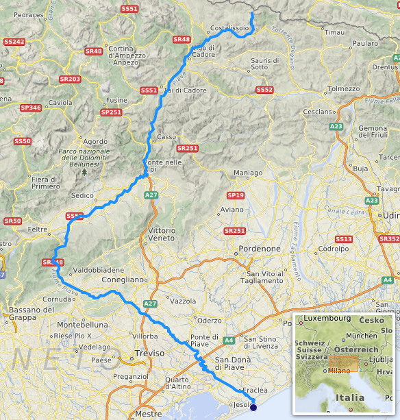
The Piave is a prominent river in northeastern Italy. Its source lies in the high Alps and it travels southeast across mountain valleys and the Venetian plain before emptying into the Adriatic Sea near the lagoon of Venice. The river is approximately 220 kilometres long and is the longest watercourse wholly contained within the Veneto region. For precise map coordinates see coordinates.
Image gallery
4 Images


Course and characteristics
The Piave rises among alpine peaks and descends through steep upper valleys, becoming a braided, faster-flowing stream in its middle reaches and a broader, meandering river as it crosses the plain. It passes through the landscape of Veneto and has served as an important watershed for agriculture and settlements in northern Italy. Its mouth opens into the Adriatic Sea close to the city of Venice.
History and cultural significance
The Piave has long been part of regional history and identity. In modern times it gained national prominence during World War I, when it formed a defensive line; the river and the events around it are commemorated in Italian memory and song. The watercourse has been featured in local literature, music and patriotic tradition.
Uses, ecology and management
The river supports irrigation, local drinking-water supplies and hydroelectric schemes in its upper basins, while navigation is limited to small craft in lower stretches. Its alpine headwaters sustain cold-water fish species, whereas human uses and seasonal variability affect ecological conditions. Authorities manage flood risk, water allocation and conservation measures to balance agriculture, energy production and habitat protection.
Notable facts and distinctions
- The Piave is the longest river running entirely within the Veneto region.
- Its alpine origin in the Alps gives it a marked seasonal flow pattern, with snowmelt influencing discharge.
- The river is identified on maps and in reference works as an important geographic feature of the region's river system and of Venice's broader maritime landscape.
For further geographic details and regional studies consult mapping resources and environmental reports available through regional institutions and archives (map data, alpine studies, coastal research, river databases, northern Italy, Venice, Veneto).
Questions and answers
Q: What are the coordinates of the Piave river?
A: The coordinates of the Piave river are 45°31′46″N 12°43′39″E / 45.52944°N 12.72750°E / 45.52944; 12.72750.
Q: Where is the Piave river located?
A: The Piave river is located in northern Italy.
Q: Where does the Piave river begin?
A: The Piave river begins in the Alps.
Q: What direction does the Piave river flow in?
A: The Piave river flows southeast.
Q: How long is the Piave river?
A: The Piave river is over 220 kilometers (140 miles) long.
Q: Where does the Piave river flow into?
A: The Piave river flows into the Adriatic Sea near the city of Venice.
Q: Is the Piave river the longest river of the Veneto region?
A: Yes, the Piave river is the longest river of the Veneto region.
Related articles
Author
AlegsaOnline.com Piave Leandro Alegsa
URL: https://en.alegsaonline.com/art/76706
Sources
- treccani.it : "Piave"
- adbve.it : "Bacino del Fiume Piave - Piano stralcio per la sicurezza idraulica del medio e basso corso"