Pforzheim — German city known for jewelry, industry and Black Forest gateway
Pforzheim is an urban city in Baden-Württemberg, Germany, known as the 'Goldstadt' for its long jewelry and watchmaking tradition, located at the edge of the Black Forest with about 116,000 inhabitants.
Pforzheim is an urban city in Germany, located in the federal state of Baden-Württemberg. Home to roughly 116,000 people, the town is widely known by the nickname "Goldstadt" (Golden City) because of its historic and still-active cluster of jewelry and watchmaking firms. Its position near the northern edge of the Black Forest has shaped local industry, transport and leisure.
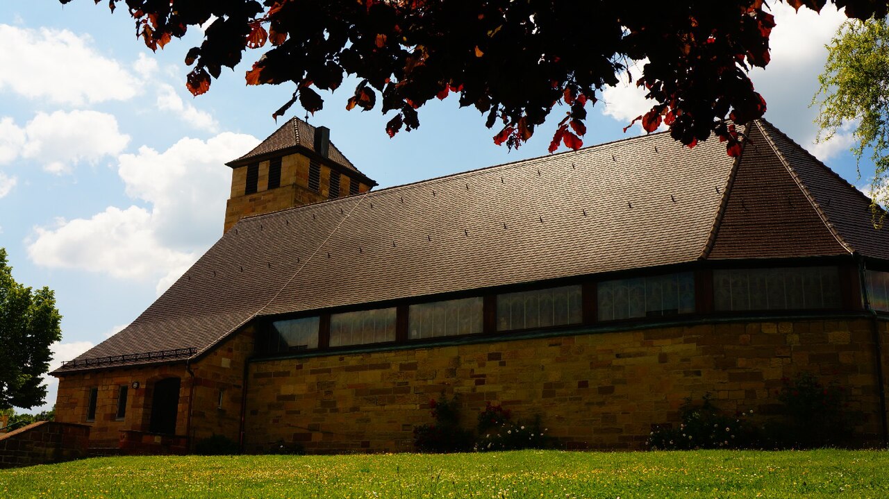
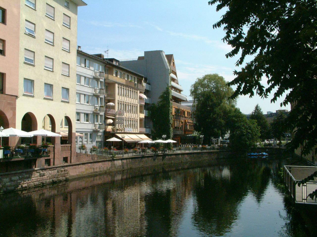
Image gallery
10 Images


Geography and setting
The city sits where several small rivers meet and at the transition from lowland plain to forested highland, offering a mixture of urban districts and nearby wooded countryside. This location made Pforzheim a natural service and manufacturing center for the surrounding region and a convenient starting point for visitors to the Black Forest.
Historical outline
Pforzheim's roots extend back many centuries as a market and craft centre that gradually gained civic rights and grew in importance. Industrialization amplified its role in precision trades, especially in the 19th and 20th centuries, when goldsmithing, watchmaking and small metalworking firms became dominant employers. The city suffered severe destruction during a major air raid in the closing months of World War II and underwent extensive postwar reconstruction and modernization.
Economy, education and culture
Jewelry, watches and related precision engineering remain central to the local economy, supported by a network of designers, apprenticeships and specialist suppliers. Pforzheim also hosts a university of applied sciences with programs in business, design and engineering that link directly to the city's creative and technical industries.
- Key cultural institutions include a dedicated jewelry museum and specialist galleries that document the city's craft history.
- Annual fairs and trade events bring makers, retailers and designers together for exhibitions and networking.
- Vocational schools and design studios maintain the skills pipeline for goldsmithing and related trades.
Pforzheim functions as an independent urban district with municipal services, parks and cultural venues serving both residents and commuters. It is connected by regional road and rail links, providing access to larger nearby cities and to recreational areas in the Black Forest. For official information and visitor details see the official municipal website.
Visitors often seek Pforzheim for its specialist shops, museums and craft workshops, or use it as a base for exploring wooded valleys and trails. The combination of industrial heritage, design education and scenic surroundings gives the city a distinctive regional role.


Geography
City breakdown
The city of Pforzheim consists of the core city and the municipalities Büchenbronn, Eutingen an der Enz, Hohenwart, Huchenfeld and Würm, which were incorporated by the territorial reform of the 1970s. According to § 8 ff. of the main statutes of the city of Pforzheim, these municipalities have a local council and a local administration to represent their locality. The formerly incorporated villages of Dillweißenstein, which was formed from the villages of Dillstein and Weißenstein shortly before the incorporation into Pforzheim, and Brötzingen belong to the core city. The modern city structure only partially corresponds to the former municipal boundaries.
· 
Brötzingen
· 
Büchenbronn
· 
Dillstein
· 
Eutingen
· 
Hohenwart
· 
Huchenfeld
· 
Würm
· 
Weissenstein
The city of Pforzheim consists of the following 15 districts. In addition to the districts with their own local administration, this also includes parts of the core city:
- Au (with Haidach, Hagenschieß and Altgefäll)
- Brötzingen (with Arlinger)
- Buckenberg
- Büchenbronn (with Sonnenberg)
- Dillweißenstein (with Sonnenhof)
- Eutingen (with Mäuerach)
- Hohenwart
- Huchenfeld
- Downtown
- Nordstadt (with Maihälden)
- East Town
- Southeast City
- Southwest City
- West Town
- Würm
Neighboring communities
The following communities border the municipality of Pforzheim. They are all located in the Enzkreis - with the exception of Unterreichenbach to the south, which belongs to the district of Calw.
In the north: Ispringen, Neulingen, Kieselbronn...
In the east: Niefern-Öschelbronn, Wurmberg, Wimsheim
In the south: Tiefenbronn, Neuhausen, Unterreichenbach, Engelsbrand
In the west: Birkenfeld, Keltern, Kämpfelbach
Floor space allocation
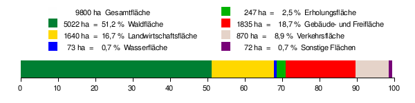
According to data from the State Statistical Office, as of 2015.
Spatial planning
The tasks of regional spatial planning are carried out by the Northern Black Forest Regional Association. Pforzheim is designated as a regional centre. The seat of the regional association is Pforzheim. The regional association comprises the city district of Pforzheim and the districts of Enzkreis, Calw and Freudenstadt.
Natural location
According to Germany's natural landscape classification, both the former city limits and the current municipal territory extend over the Gäu region (Enz valley, Kraichgau) and the Black Forest. The town centre lies in a widening of the Enz valley at the confluence of the Nagold and Enz rivers. The bedrock in the valley bottom changes from shell limestone (Gäuland) to red sandstone (Black Forest). From a natural point of view, the Enz valley from Birkenfeld and including the city centre of Pforzheim is counted as part of the Gäuland. The Nagold takes in the Würm at the southern edge of the city, which is why Pforzheim is often referred to as a three-river city. The outlying districts and incorporations also extend to the plateaus of the Black Forest and Kraichgau to the south and north, Dillstein and Weißenstein lie in the Nagold valley moving south, Würm in the Würm valley moving southeast. Water volume and catchment area of the Nagold are much higher at the confluence with the Enz, nevertheless the river is called Enz in the further course.
The municipal area of Pforzheim covers the following natural units (recorded for the Geographical Survey of Germany):
- 12 Neckar-Tauber-Gäue (Gaeu areas shaped by the Muschelkalk, which also extend to the east and north of the Black Forest)
- 122 Obere Gäue (after Kraichgau and Neckar basin the third large Gäu area in the Pforzheim region, extends between Würm and Baar and begins a little southeast of the city limits)
- 123 Neckar basin (wide Gäu basin between Stuttgart and Heilbronn)
- 123.1 Southwestern Neckar Basin
- 123.10 Eastern Hagenschieß
- 125 Kraichgau (also includes areas which are not considered to be part of the Kraichgau proper, e.g. the Enz valley in Pforzheim)
- 125.3 Pfinzhügelland (includes areas outside the catchment area of the Pfinz, e.g. the Pforzheimer Enztal)
- 125.32 Eastern Pfinzgau
- 125.33 Building solder plate
- 125.34 Pforzheim Enz valley
- 15 Black Forest (low mountain range between Pforzheim and Hochrhein, in the Pforzheim area characterised by red sandstone)
- 150 Black Forest edge plates (along the northern and eastern edge of the Black Forest)
- 150.1 Eastern Black Forest Rim Plates
- 150.13 Enz-Nagold plate
There are therefore a total of five natural sub-units in the Pforzheim municipal area:
125.34 Pforzheimer Enztal: Central natural subunit for Pforzheim, around which the other subunits are grouped. The Pforzheimer Enztal extends in a southwest-northeast direction from Birkenfeld to Enzberg. While the upstream areas belong to the Black Forest to the south and the downstream areas belong to the Neckar Basin to the east, the Pforzheim Enz Valley belongs to the Kraichgau region, which extends to the north and west of Pforzheim. In this unit are mainly the Pforzheim districts of Innenstadt, Oststadt, in Eutingen is river downstream the left bank of the Enz the rise to the Bauschlotterplatte. On the right of the Enz the edge plate black forest runs out in the Eutinger oak forest and goes over in Niefern into the Neckar basin (nature area 125), north city, west city and Brötzingen as well as the northern areas of the districts southwest city and southeast city. The Pforzheim Enztal is a 150 m deep bottom valley with terraced valley slopes. The wide, wetted valley floor consists of a floodplain clay cover overlying red sandstone gravels. The valley floor and valley slopes are almost completely built up.
125.33 Bauschlotter Platte: Extends north of the Pforzheim Enz valley, named after the village of Bauschlott. The northern parts of the Pforzheim districts of Nordstadt and Eutingen are located in this unit. The Bauschlotter Platte is a slightly disintegrated shell limestone plateau with soils very well suited for agriculture (Korngäu type). However, the fertile arable land based on it is increasingly being lost due to the new Hohenäcker industrial estate spreading out around the Pforzheim-Nord motorway junction. The low degree of erosion of the Bauschlotter Platte indicates that the direct Rhenish erosion has hardly arrived here yet.
125.32 Eastern Pfinzgau: Extends northwest of the Pforzheim Enz valley. The northwestern parts of the Pforzheim district Nordstadt (especially the industrial area Wilferdinger Höhe) are located in this unit. It is a strongly disintegrated shell limestone plateau of the Heckengäu type.
150.13 Enz-Nagold-Platte: Extends south of the Pforzheim Enz valley and has a misleading designation as it mainly includes the Nagold area. The southern areas of the Pforzheim districts of Südweststadt and Südoststadt as well as the districts of Büchenbronn, Dillweißenstein, Huchenfeld, Hohenwart, Würm and Buckenberg with Haidach are mainly located in this unit. This Black Forest plateau, built mainly of red sandstone, is predominantly forested and relatively extensive (reaching as far as Altensteig in the south). The valleys of the Nagold are deep and cut into the plate with steep slopes. On the Riedeln between the valleys there are clearing islands (e.g. Huchenfeld and Hohenwart).
123.10 Östlicher Hagenschieß: Comprises a small area southwest of the Pforzheim Enz valley. The designation is misleading, as the unit includes not only the eastern half of the Hagenschieß, but also adjacent Gäu areas to the east (Wurmberg and Wiernsheim). The Hagenschieß in itself is a large wooded area in the east of the city, most of which belongs to Pforzheim. While the western Hagenschieß belongs to the Black Forest (to the unit "150.13 Enz-Nagold-Platte"), the eastern Hagenschieß is counted to the Neckar Basin, as it is predominantly a shell limestone plateau (Wellengebirge). Despite its arable suitability, the eastern Hagenschieß is largely forested for historical reasons (former cooperative forest of the surrounding communities).
Nature reserves
Pforzheim has a share in three nature reserves. The Felsenmeer, with its size of 5.6 ha, as well as the nature reserve Mangerwiese-Wotanseiche, with its size of 65.4 ha, are completely located on Pforzheim's municipal territory. Pforzheim has a share of 125.8 ha in the nature reserve Unteres Würmtal, which covers a total of 158.5 ha. A total of 196.80 hectares are under nature conservation, which is 2.01 percent of the municipality's area.
Dialect Geography
Pforzheim lies in an area where Swabian and South Franconian dialect features mix. This transitional area extends from the northern Black Forest eastwards to the south of Heilbronn and has a relatively large north-south extension at Pforzheim's latitude (in the south beyond Calw and Weil der Stadt). Pforzheim lies rather at the northern edge of this transition area.
In the Pforzheim area, the language borderlines are geographically hardly oriented to natural borders and connecting routes, but rather to earlier political and ecclesiastical borders. The first influence was the new political northern border of Alemannia drawn around 500, through which the Alemannic-populated area of Pforzheim came under Frankish rule and was influenced linguistically accordingly. The new border ran about 20 km south of Pforzheim, near Calw. Later the area near Pforzheim became part of Baden. However, this Baden area always extended finger-shaped into the surrounding Württemberg area and took part in the linguistic development from a former Alemannic to a new Swabian language area. Therefore, diverse fine linguistic border lines still separate the Pforzheim region linguistically from the northern Baden area around Karlsruhe.
The actual city dialect of Pforzheim was characterized by numerous interactions between native and immigrant dialects. The dialect of the Au district, which was dominated by rafters, contrasted with the dialect of the actual core city, which was dominated by merchants and craftsmen. The increasingly rural settlement of the Old Town to the east of the town also had its own character. Through industrialization, immigration and urban growth, Au and Alte Stadt lost their linguistic characteristics. Industry-induced immigration (mainly between 1870 and 1910, but also before the 18th century) was mainly from the Swabian-speaking areas. Sexauer distinguished four dialect groups in the early 20th century: the conservative Au-Dillstein dialect, an older and a younger city dialect, and the dialect of the immigrants. The city dialects abandoned South Franconian in favour of Swabian dialect features, but South Franconian innovations also found their way in. Over time, the influence of the written language in particular grew. With it, the formerly strong French influence in the city dialect was lost, as were various expressions typical of the jewellery industry.
Climate
| Pforzheim 2010-2020 | ||||||||||||||||||||||||||||||||||||||||||||||||
| Climate diagram | ||||||||||||||||||||||||||||||||||||||||||||||||
| ||||||||||||||||||||||||||||||||||||||||||||||||
| Monthly average temperatures and precipitation for Pforzheim 2010-2020
Source: [2] | |||||||||||||||||||||||||||||||||||||||||||||||||||||||||||||||||||||||||||||||||||||||||||||||||||||||||||||||||||||||||||||||||||||||||||||||||||||||||||||||||||||||||||||||||||||||||||||||||||||||||||||||||||||||||||||||||||||||||||||


History
Overview of the history of political events
Before the Roman conquest in the first century AD, the area of today's Pforzheim lay in the territory of the Celts. Direct traces of the Celts can be found from the time 500 to 300 BC. A bronze horse figurine found near Pforzheim dates from this early Celtic period. A statue of the Celtic goddess of healing, Sirona, was recovered from a well. A fragment of an altar found during the great regulation of the Enz River in 1909 near the Old Town Church is attributed to the Celtic Black Forest goddess Abnoba. The find led to the naming of the Enuferweg as Abnobastraße. The Roman era lasted until the 3rd century, during which time a ford was established on the Enz for the Strasbourg-Cannstatt Roman road. The resulting settlement was called Portus. Near Neuenbürg/Waldrennach there is evidence of melting furnaces/race furnaces of the Celts for iron extraction (mine "Grube Frischglück", Neuenbürg). Roads or waterways were necessary for the further processing and transport of the iron products. Therefore, it can be assumed that the Enz ford was already important in Celtic times.
Around 259/260 Alemannic population groups overcame the Limes. Around 500, Alemannia was incorporated into the Frankish Empire. The northern border of Alemannia was thereby shifted far to the south; if it had previously been close to the Main, it now ran far south of Pforzheim, near Calw. Possibly in the 11th century, Pforzheim was part of Salian territories and passed from the Salians to the Staufers in 1125.
By marriage Pforzheim came to the Guelphs in 1195 and a few years later, 1220-1227, again by marriage, from the Guelphs via Frederick II to the von Baden. The process of becoming a town possibly began as early as the Hohenstaufen period and lasted until the 14th century. In 1344, ownership of the parish church (included both St. Martin and St. Michael) passed from the Hirsau monastery to the Lichtenthal monastery. Between 1462 and 1750 Pforzheim was merely a fief of the Electorate Palatinate with Baden. An order of the margrave of Baden, Christoph I, brought the loss of political autonomy to the city in 1486.
Jörg Ratgeb was involved in the peasants' uprising in 1525 in the Duchy of Württemberg for the rebels. This became his undoing. After the suppression of the uprising on May 18, 1525 near Böblingen by the Truchsess von Waldburg-Zeil, he was imprisoned and sentenced in Pforzheim on the basis of the Bamberg Halsgerichtsordnung. The sentence was "for the sake of the Paurenkrieg and Hertzog Ulrich" to be cut into four pieces by horses while still alive and was carried out on the market square in front of today's town hall.
After the division of Baden, Pforzheim (then also Pfortzhaim) belonged from 1515/1535 to 1771 (with interruptions) to the Lower Margraviate of Baden (Ernestine line, later also called the Margraviate of Baden-Durlach). In 1535 Pforzheim was chosen as the residence of the Lower Margraviate, but the residence was moved to Durlach as early as 1565. Pforzheim also became the central burial place of the Ernestine line in 1538 and remained so for the united Baden after 1771.
Between 1519 and 1556 the Reformation was introduced in Pforzheim and Baden-Durlach. Due to the sale of Liebenzell and other territories to Württemberg in 1594 and the following years, Pforzheim fell to the periphery of Baden-Durlach. During the Thirty Years' War (1618-1648) the town was mostly out of Baden's grasp (1624-1635 occupation by imperial or Swedish troops, 1635-1645 Pforzheim belonged to Bavaria).
In 1803 Baden became an electorate, in 1806 a grand duchy. Between 1871 and 1933 Baden was a federal state of the German Reich, since 1918 as a free state. Under the Nazi regime of the German Reich, Baden and Pforzheim were brought into line in 1933 (abolition of the rights of the constituent states, appointment of the mayor of Pforzheim by the NSDAP, reshuffle of the city council on the basis of the Reichstag election results in 1933). From April 1945, the city belonged to the French occupation zone for a few months, and from July 1945 to 1949 to the US occupation zone, in which the state of Württemberg-Baden was established. In 1952 Württemberg-Baden was absorbed into the state of Baden-Württemberg.
Historical political geography
Before the Napoleonic adjustment in 1803/1806, the parishes located in the present-day Pforzheim city area belonged predominantly to the Baden-Durlachian Oberamt Pforzheim. Other municipalities of the Pforzheim district (e.g. Dietlingen, Ispringen, Eisingen, Bauschlott, Dürrn, Niefern) were located mainly in the north and northwest, as were other Baden areas, namely the Stein and Frauenalb districts. The present-day Pforzheim districts of Würm and Hohenwart belonged to family territories organized in the imperial knighthood, both under Baden sovereignty. Hohenwart was part of the land of the imperial knightly family of Gemmingen-Steinegg, the so-called Biets, which lay in the southeast along the Würm and remained Catholic. To the east and southwest lay Württemberg territories, above all the Neuenbürg and Liebenzell offices in the southwest and the extensive territory of the Maulbronn monastery office in the east.
Early history
The town goes back to a Roman settlement at an Enz ford (around 90 AD), the name probably from the Latin portus = harbour/stacking place.
The first document, the Roman Leugenstein of Friolzheim from 245 AD, refers to the Roman settlement portus. The settlement was located on the Roman military road between the Upper Rhine and Neckar regions precisely where the long-distance trade and military road crossed the Enz in a ford, shortly after joining the Nagold. It was probably already at this time that rafting became established in the Roman settlement, as the Enz became navigable from Portus onwards due to the inflow of the Nagold and Würm rivers. Nothing is known about a presumed harbour on the Enz. With some probability the Latin name is incompletely handed down and had further components. A widespread misconception, dating back to Philipp Melanchthon, is that the name Pforzheim can be traced back to porta = gate/Porta Hercyniae (to the Black Forest). Reuchlin's speculative derivation of the name from the Trojan Phorkys as mythical founder of the city is also wrong.
Large Roman buildings begun in the 3rd century suggest that the small craftsmen's settlement was to be developed into an administrative centre, such as a civitas capital. In 259 and 260, Franks and Alamanni conquered the areas of the Roman Empire on the right bank of the Rhine. The settlement of Portus was razed to the ground. The tradition about the settlement breaks off for the time being.
Some pottery sherds and coins make a continuation of the settlement probable, but the settlement continuity could also have been very weak in real terms. A settlement only really becomes tangible again with the row graves from the 6th and 7th century, which, however, lie about 800 m downstream of the Roman settlement. Later, during the Carolingian period, the Old Town of Pforzheim grew over the Roman settlement itself. A testimony to this time is, among other things, the burial site at the Kappelhof in the basement of the Caritas building.
1067 to 1500
In 1067 Pforzheim was mentioned for the first time in a document of Emperor Heinrich IV, around 1080 the settlement received the right to hold markets. Documented visits to Pforzheim by Heinrich IV were in the years 1067 and 1074. In 1100, the codex of the Hirsau monastery showed that the Old Town of Pforzheim already had market rights before 1100 and was owned by the Hirsau monastery. In the 12th century, the Old Town was monastic and ecclesiastical with a St. Nicholas Chapel (patron saint of rafters and boatmen), under the protection of an early St. Martin's Church, and had competition from a new settlement core (Neustadt), below a castle hill 800 m upstream with a St. Michael's Chapel (today's Schlossberg with castle church). The new town grew quickly.
In 1220 the margraves of Baden chose Pforzheim as their residence. The focus shifted in favour of the New Town; the Old Town lost importance. In 1240 a Pforzheim mayor is mentioned in a document for the first time. In 1447, the marriage of Margrave Karl I of Baden to Katharina of Austria, the sister of Emperor Frederick III, was celebrated with great pomp at the Pforzheim Princely Wedding.
In the second half of the 15th and 16th centuries, the Pforzheim Latin School developed into one of the most important schools of learning in southern Germany. Its teachers and students played an important and prominent role in the spread of humanism and the Reformation. Among the most famous students were Philipp Melanchthon and the Pforzheim-born humanist Johannes Reuchlin. He is the namesake of the Reuchlinhaus cultural center, which was inaugurated in 1961 and includes an international jewelry museum, as well as the Reuchlin High School. In addition, the Reuchlin Prize was named after the scholar. The award was first presented in 1955 on the occasion of the celebration of the 500th birthday of Johannes Reuchlin.
1500 to 1680
See also: Baden-Durlach
In 1501 Margrave Christoph I issued the order of the rafters or skippers in Pfortzheim. One of the oldest trades in Pforzheim is rafting. The single logs and small rafts from the Black Forest (the long and straight firs were ideal as building material) rafted over the Enz, Nagold and Würm were re-tied in the Pforzheimer Au to large rafts for the lower Enz and the waterline Neckar/Rhine. The rafting stations of Weißenstein, Dillstein and Pforzheim were well known to every rafter of the past centuries. At that time, Pforzheim also had a customs station where rafters had to pay a fee for navigating the waterways.
From 1535 to 1565 the town became the residence of the Baden Margrave Ernst I during the division of the Baden lands by inheritance. Afterwards the residence was transferred to Durlach, which is why one speaks of the Baden-Durlach line. However, the town remained the seat of a Baden office and the castle church continued to be the burial place of the Baden margraves. Ernst's son Charles II introduced the Reformation in 1556. The monastery church of the Dominicans became the Lutheran town church. In 1618, at the beginning of the Thirty Years' War, Pforzheim had about 2500 to 3000 inhabitants and was thus by far the largest of the towns of the Margraves of Baden. By this time, Pforzheim had already lost much of its importance, partly because many upper-class families (patricians) left the town in the 15th century.
In 1645, towards the end of the Thirty Years' War, Bavarian troops burned down the Old Town. It was rebuilt without fortifications; this sealed its status as a village-like hamlet, and it disappeared from the historical record except for a few marginal notes. The new town continued to exist. In the 13th-15th centuries, Pforzheim flourished economically due to the energetic support of the margraves of Baden, who regarded the town as the most important base of their household power, and its favourable location at the crossroads of major trade routes. The timber trade and rafting, tanning, cloth and cloth-making contributed to the wealth of the town, as did the handicrafts. Three religious orders settled in the town. The last decades of this heyday, in which the political and economic supremacy began to waver, are highlights of the town's history from an intellectual point of view.
1680 till 1830
From 1689 to 1697, the War of the Palatinate Succession caused great destruction in southwestern Germany. Pforzheim was plundered and burned down a total of three times by French troops under the command of King Louis XIV. Brigadier Comte Ezéchiel de Mélac was responsible for the occupation of the town in October 1688, the devastating burning of the town in January 1689, the artillery bombardment and a second burning in August 1689. Further destruction was under the command of Marshal Joseph de Montclar and Marshal Duc de Lorge. Furthermore, Duc de Villeroy was responsible for the artillery bombardment of the city and the sacking in August 1691. Under General Chamilly, the city was again occupied and sacked in September 1692. The princely crypt in the castle church was devastated in the process.
In 1718, the Pforzheim orphanage (Landeswaisenhaus) was opened in the building of the former Dominican convent. This orphanage, tollhouse, infirmary, penitentiary and workhouse later became the nucleus of the jewellery and watch industry that still exists today.
In 1767 the jewellery and clock industry was founded in Pforzheim by Margrave Karl-Friedrich. With the support of an entrepreneur from Switzerland, a watch factory was set up in the orphanage to employ the orphans. Some time later, the manufacture of jewellery was added. The company developed rapidly and was soon exporting all over the world, although watch production soon disappeared and only experienced a renaissance from 1920 onwards with the manufacture of wristwatches. Around 1800, Pforzheim was considered the first factory town in Baden with 900 factories and the most important centre of costume jewellery production in the world. Many of the 26,000 employees came from the surrounding area and were thus commuters. These were called Rassler. In 1809, the Baden office of Pforzheim was divided into a city office and a First and Second Land Office. However, the latter two were reunited in 1813 to form the Landamt Pforzheim. In 1819, the City and County Offices of Pforzheim were united to form the Superior Office of Pforzheim, which was transferred to the District Office of Pforzheim in 1864.
See also: Karl Friedrich (Baden)
1830 until 1918
In 1836, Ferdinand Oechsle developed the must scale in the city, which is still used today to measure the must weight of freshly pressed grape juice in degrees Oechsle. From 1861 to 1863, the construction of the Karlsruhe-Mühlacker railway line connected Pforzheim to the railway network. In 1868 and 1874, with the construction of the Enztalbahn and the Nagoldtalbahn, the two large Black Forest valleys leading into Pforzheim were also connected to the railway. This ushered in the end of rafting.
In 1888, the year of the Three Emperors, Pforzheim was the destination of the first overland journey by automobile, which Bertha Benz, a native of Pforzheim, undertook from Mannheim with her two sons without the knowledge of her husband Carl Benz. Since 2008, the Bertha Benz Memorial Route has commemorated this pioneering act. Ten years later, the entrepreneur Bernhard Heinrich Mayer was the first person from Pforzheim to acquire his own automobile, a Benz "Victoria".
Jewish families had been resident in the city since the 19th century. They established the Jewish cemetery in 1846, which was occupied until 1877, after which a Jewish cemetery was established in the new interdenominational Pforzheim main cemetery. In 1893 the Jewish community built a synagogue. In the 19th century the textile, metal and jewellery factories in Pforzheim formed the industrial centre of the Grand Duchy of Baden.
Pforzheim's master builder Alfons Kern founded the city's cultivation of tradition. He planned the new town hall building of 1893/1895 and rendered outstanding services to the establishment of a municipal collection of antiquities and paintings as well as the enlargement and reorganization of the town archive. In 1905 he resigned from the building authority and now devoted himself solely to the expansion of the collections, which moved into their own buildings in the 1920s and 1930s. Kern was awarded honorary citizenship of the city in 1939, and the painting collection bore his name from that year on.
Furthermore, in the course of the years 1830 to 1918, two previously autonomous parishes were incorporated; the Brötzinger parish was incorporated at the turn of the year 1904/1905, the Dillweißensteiner at the turn of the year 1912/1913. A total of 1762 ha were incorporated in parallel.
1918 to 1945
During the November pogroms in 1938, the Old Synagogue Pforzheim was desecrated and severely damaged. The Jewish community was obliged to bear the costs of demolition. On 22 October 1940, 186 Jews remaining in the city were deported in the Wagner-Bürckel action. Only a few survivors returned.
In 1939, the Pforzheim District Office became the Pforzheim County, whose seat was Pforzheim. At the same time, the city became a district-free city. In 1944, 18,622 workers were employed in 101 companies, at least 10,000 of them in the armaments industry.
Pforzheim industry played a major role in the development of technological innovations such as the X-beam method for better target acquisition (developed by G. Schaub Apparaturenbau-GmbH, used against Coventry, among others). In some areas of on-board radio equipment, up to 50% of the parts came from Pforzheim. In order to satisfy the increasing demand, Pforzheim companies also resorted to forced laborers, such as forcibly deported workers from the Vosges (from the fall of 1944), interned Italian prisoners of war (from 1943/44), forced laborers from the Ukraine and Russia. The request for concentration camp prisoners is known.
On the outskirts of the city was a factory for the production of anti-aircraft grenades. In addition, the city played a key role in the rail transport of military units. Should the north-south line in the Rhine valley fail, the town, which lay on the alternative route over the Black Forest and provided a connection to the east-west lines, would have been an important transshipment point for supplies to the southern eastern front and the western front. However, the British Royal Air Force originally listed Pforzheim only as a lower-ranking alternate target in the target hierarchy.
On February 23, 1945, during the air raid on Pforzheim, 379 British bombers almost completely destroyed the city within 22 minutes. At least 17,600 people were killed. The bombs and the firestorm that developed in the closely built-up old town killed almost a third of the population present. In terms of casualties, it was the third heaviest attack by Allied bombers during the Second World War, after the bombings of Hamburg and Dresden. 98% of the city centre was destroyed. Pforzheim was thus one of the most heavily destroyed cities during the war. Overall, this attack was the most concentrated and consequential by the Allies. Its aim was also, as elsewhere, to demoralize the population; perhaps the precision engineering industry, which had largely switched to the production of detonators during the war years, also played a role. However, since some of the factories had been outsourced, the attack may also have been aimed directly at the old town, which, with its half-timbered houses, was chosen as a quick-burning target.
See also: List of Allied air raids on the German Reich (1939-1945)
Germany ultimately lost the Second World War step by step. Still at the beginning of April 1945, Pforzheim was declared a so-called fortified place, which meant that the city was to be defended relentlessly. From April 8 to April 18, the city was completely occupied by French troops. Elsewhere in Germany, the war continued until early May. It finally ended on 8 May with the unconditional surrender of the Wehrmacht.
Since 1945
From 1945 to 1948 Pforzheim was under US military administration (after initial French occupation) and was part of the new state of Württemberg-Baden. During these and the following years, the population grew again due to the influx of displaced persons, refugees, resettlers and immigrants. As early as 1950, Pforzheim's industry was once again recording export sales in the millions. The city was already booming, the reconstruction plan had hardly been noticed by the citizens in 1946 and had been passed almost unanimously.
Today's cityscape is characterised by the functionalist architecture of the 1950s. As in many war-damaged cities, Pforzheim in the immediate post-war period was also concerned with the rapid reconstruction of the urban infrastructure. Representative individual buildings in the architectural style of these years are the main railway station, the district court and the Reuchlinhaus. The Protestant City Church, inaugurated in 1968, also follows this sober architecture. Only in the northern and southern parts of the city are there stylistically older buildings. Exemplary streets with a significant number of buildings from the pre-war period are Zähringerallee and Nebeniusstraße.
In 1955, the city of Pforzheim endowed the Reuchlin Prize, named after the Pforzheim humanist Johannes Reuchlin, for outstanding German-language work in the field of the humanities.
In the 1960s, the Wilferdinger Höhe was developed and later industrially and commercially built on; previously there were orchards and fields. Other commercial areas are Hohenäcker and Brötzinger Tal.
On July 10, 1968, an F4 tornado struck the city and surrounding area. Two people died, over 200 were injured, 2300 houses were damaged.
During the district reform on 1 January 1973, the district of Pforzheim was absorbed into the newly formed Enzkreis, whose seat became the city of Pforzheim. It itself remained district-free. Pforzheim also became the seat of the Northern Black Forest region, which was formed in 1973. On 1 January 1975, the number of inhabitants exceeded 100,000 with the incorporation of Huchenfeld, making Pforzheim a large city. In 1983 the Heimattage Baden-Württemberg took place in Pforzheim. Pforzheim East was redesigned for the State Garden Show in 1992. At the end of the 20th century, the production of jewellery and watches in Pforzheim lost much of its importance. In addition, the Maihälden area was developed in the 1990s and subsequently extensively built on.
Since 1999/2000 some parts of the city have been redeveloped.


Related articles
Author
AlegsaOnline.com Pforzheim — German city known for jewelry, industry and Black Forest gateway Leandro Alegsa
URL: https://en.alegsaonline.com/art/76313
Sources
- destatis.de : "Alle politisch selbständigen Gemeinden mit ausgewählten Merkmalen am 31.12.2018 (4. Quartal)" · web.archive.org
- destatis.de : destatis.de/DE/ZahlenFakten/LaenderRegionen/Regionales/Gemeindeverzeichnis/Administrativ/…
- destatis.de : "Gemeinden in Deutschland nach Fläche, Bevölkerung und Postleitzahl am 30.09.2016"