Pee Dee River (Great Pee Dee)
Major river of North and South Carolina, rising in the Appalachians, continuing from the Yadkin, and flowing to the Atlantic with historic, ecological, and economic importance.
Overview
The Pee Dee River, often called the Great Pee Dee, is a prominent waterway in the southeastern United States. It rises in the highlands of the Appalachian region and flows generally southeast to the Atlantic coast. The river's upper reaches are known as the Yadkin River until the confluence with the Uwharrie system; below that point the watercourse is commonly called the Pee Dee. The river and its basin have shaped settlement, commerce, and ecosystems in portions of both North Carolina and South Carolina. Geographic coordinates frequently given for a central point along the river include 34°43′16″N 79°52′54″W.
Image gallery
2 Images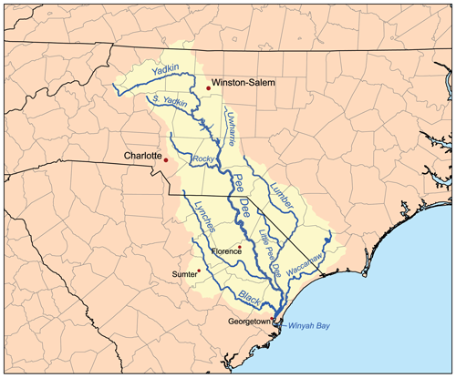
Course and physical characteristics
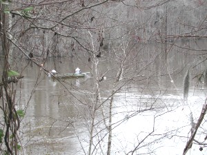
The Pee Dee watershed collects water from upland hardwood forests, piedmont hills, and coastal plain lowlands before reaching a tidal estuary near the Atlantic. Its identity as the Pee Dee begins where the Yadkin system transitions and continues through a mixture of meanders, bottomland hardwoods, and marshy floodplains. Downriver the channel broadens and becomes influenced by tides and brackish waters as it approaches Winyah Bay and the ocean. Along its course the river receives numerous tributaries and supports a range of environments from clear upland streams to wide, slow-moving lowland reaches.
Tributaries, towns, and features
Key features of the basin include reservoir systems, wetlands, and agricultural floodplains. The river has been modified in places by dams and impoundments for flood regulation and energy production, and these structures influence flow patterns and sediment transport. Communities and cities established near the river have long used it for transport, industry, and water supply. Notable human and natural elements associated with the Pee Dee include:
- Major feeder and related rivers, including the Yadkin above the name change and tributary systems linked to the Uwharrie country.
- Urban and rural centers that developed along its banks and relied on the river for mills, navigation, and irrigation.
- Reservoirs and managed reaches created to mitigate flooding and provide power and recreation (dam works and flood control projects).
History and name
The river and the surrounding region take their modern English name from the Indigenous Pee Dee (Pedee) people, who lived in the area at the time of European contact. Early European explorations interacted with the river in the 16th and 17th centuries: a Spanish reconnaissance led by associates of Lucas Vázquez de Ayllón is recorded to have traveled portions of the coast and river in 1521, giving it a name in Spanish as Rio de San Juan Bautista. Later English maps and colonial documents used variants such as Pedee and Pee Dee. The river therefore carries layered names and stories reflecting Indigenous presence and European exploration (Native American history and early Europeans).
Uses, ecology, and significance
The Pee Dee basin supports a diversity of fish, waterfowl, and wetland plants, especially where freshwater meets tidal estuary. Its floodplains host productive soils that have supported agriculture for centuries. Recreational activities such as boating, fishing, and birdwatching are common, and protected areas along the river help conserve habitat. At the same time, managed flows, dams, and land-use changes have altered native habitats, so conservation and resource-management efforts are ongoing.
Regional identity and notable facts
The name of the river also identifies a broader cultural and geographic area known in South Carolina as the Pee Dee region; that regional name derives from either the Indigenous people or the river itself (Pee Dee region, Pee Dee tribe). The river's dual naming with the Yadkin in its upper course (Yadkin) and its appearance in early Spanish accounts underline its long role as a corridor of travel, trade, and ecological connection across state lines. Researchers, managers, and local communities continue to balance navigation, energy, agriculture, and habitat protection in the Pee Dee watershed.
For additional maps, conservation plans, and historical summaries consult regional resources and archives that document the river's geography, management, and cultural history (Appalachian headwaters, coordinate references, and local repositories in South Carolina and North Carolina).
Further reading and resources: see hydrology studies, ecological assessments, and cultural histories that explore how the Pee Dee has shaped—and been shaped by—people and the landscape (colonial history, Indigenous perspectives, and infrastructure reports on dams and flood control).
Related articles
Author
AlegsaOnline.com Pee Dee River (Great Pee Dee) Leandro Alegsa
URL: https://en.alegsaonline.com/art/75432
Sources
- geonames.usgs.gov : U.S. Geological Survey Geographic Names Information System: Pee Dee River
- sac.usace.army.mil : "Great Pee Dee River Basin; Report No. 11"
- commons.wikimedia.org : Pee Dee River