Paris: an overview of France’s capital, geography, culture and transport
Comprehensive overview of Paris: location, geography, history, culture, economy, transport and notable facts about the French capital.
Overview
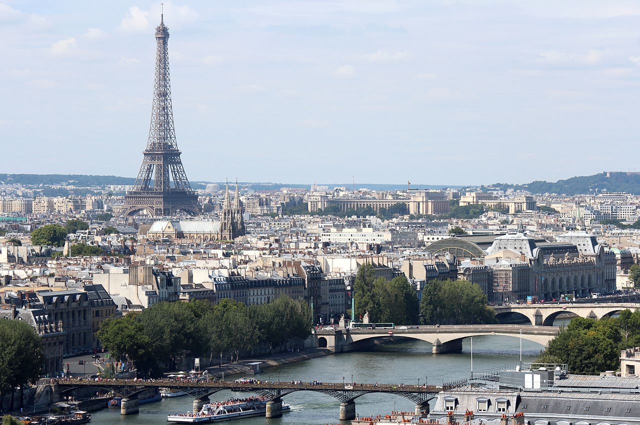
Paris, often called the "City of Light", is the capital and largest city of France. The commune covers roughly 105 square kilometres and contains a population of about 2.1 million people inside its municipal limits; the broader urban area is home to many millions more. As a national centre for government, commerce and culture, Paris has a significance that extends well beyond its administrative boundary.
Image gallery
6 Images


Geography and layout
The historic core of Paris is located on and beside the river Seine, which bisects the city and gives rise to the familiar designations of the Right Bank (north) and the Left Bank (south). Paris is relatively compact compared with many global capitals and is ringed by suburban departments and green belts; there are several notable forests and parks on its outskirts that shape its metropolitan footprint (nearby woodlands). Because so many people live within the municipal area, Paris ranks among the most densely populated cities in the European Union.
History and development
Paris has origins in a small Iron Age settlement that grew into a Roman town and, over centuries, became the political and cultural heart of the French realm. Medieval neighbourhoods, Renaissance churches and wide 19th‑century boulevards reflect layers of development. Major urban transformations during the 1800s reshaped streets, public spaces and infrastructure; many of the city’s landmarks date to these earlier periods or to subsequent restorations.
Culture, arts and institutions
The city is a global cultural hub, home to world-class collections of art and historic institutions such as major museums. Parisian theatres, galleries and concert halls play prominent roles in national life, and cuisine ranges from traditional French brasseries to international restaurants reflecting a diverse population. Paris also functions as a centre for media, fashion and higher education, and remains an influential voice in European and global cultural affairs (cultural scene).
Economy, government and transport
As the seat of national government and many large corporations, Paris is central to the French economy and to national politics. The city’s transport network is extensive: an underground rapid transit system, the Metro, opened around 1900 and today covers well over 200 kilometres of routes. River transport, buses and regional rail link the core to suburbs and neighbouring regions. Paris is served by two major international airports, which connect it to destinations worldwide.
Landmarks, distinctions and practical notes
Visitors often think of emblematic sites when they picture Paris. Important examples include:
- Historic landmarks — cathedral, palaces and monuments that embody centuries of history.
- Museums and galleries — institutions preserving art, archaeology and cultural collections.
- Public spaces — boulevards, parks and riverfronts used daily by residents and visitors.
Paris has long been among the world’s most visited cities. It also faces modern urban challenges such as air and light pollution, housing and transport congestion. The city’s multicultural population contributes to a wide range of languages, cuisines and social life. For current practical information about visiting, cultural programming or municipal services, consult official resources or specialist guides (nickname, country, EU context, Seine, green areas, economy, government, culture, art, museums, Metro, airports).


Geography
enlarge and show information about the picture
![]()
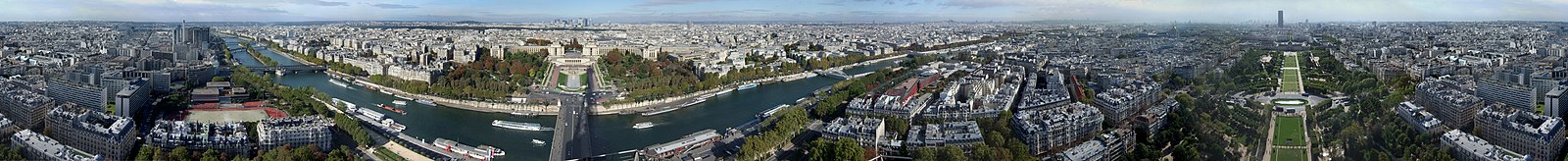
360° panorama of Paris, photographed from the Eiffel Tower. A detailed description of the panorama can be found here
Location
The city area has a surface of 105.4 square kilometers. This is roughly equivalent to the area of Mainz and less than 12% of the area of Berlin. The metropolitan region covers a ground area of 14,518 square kilometres. This is roughly equivalent to the area of Schleswig-Holstein. The city is located in the center of the Paris Basin, an average of 65 meters above sea level. The Seine, depending on the water level, leaves the city area at 25 meters above sea level. Paris is surrounded by the two large city forests, which serve the population as recreational areas.
Climate
Paris is located in the temperate climate zone. The mean annual temperature is 10.8 degrees Celsius and the average annual rainfall is 649.6 millimeters. The warmest month is July with an average of 18.4 degrees Celsius, the coldest is January with an average of 3.5 degrees Celsius. The most precipitation falls in May with 65.0 millimeters on average, the least in August with an average of 43.0 millimeters.
Regular meteorological measurements have been taken in Paris since 1873. The lowest temperature recorded so far was -23.9 degrees Celsius and dates back to 10 December 1879. The warmest record is 42.6 degrees Celsius and was measured on 25 July 2019 at Parc Montsouris. The previous highest air temperature record was 40.4 degrees Celsius and had also been recorded at Parc Montsouris on July 28, 1947.
| Paris | ||||||||||||||||||||||||||||||||||||||||||||||||
| Climate diagram | ||||||||||||||||||||||||||||||||||||||||||||||||
| ||||||||||||||||||||||||||||||||||||||||||||||||
| Monthly average temperatures and precipitation for Paris
Source: Météo-France; humidity, sunshine duration: wetterkontor.de | |||||||||||||||||||||||||||||||||||||||||||||||||||||||||||||||||||||||||||||||||||||||||||||||||||||||||||||||||||||||||||||||||||||||||||||||||||||||||||||||||||||||||||||||||||||||||||||||||||||||||||||||||||||||||||||||||||||||||||||||||||||||||||||||||||||||||||
Geology
The Paris Basin forms a large stratigraphic landscape. The layers of the Mesozoic and the Palaeogene (formerly Old Tertiary) lie here in a bowl shape, one inside the other, and have been worked out by erosion into a wide-stretched stepped landscape, the steps of which are each directed outwards.
Only in the eastern part do tectonic fault lines prevail on the slope of these steps towards the Saône furrow. They cause the steep slopes of the plateau of Langres and the Côte d'Or (up to 636 meters), which are famous wine-growing areas because they have greater sunshine duration in the rain shadow of the leeward side and also enjoy the advantages of southern exposure.
There is a certain unevenness in that the sequence of strata is more perfect in the northeastern part than in the west. The somewhat greater elevation of the eastern wing has also generally brought with it greater differences in elevation and a more prominent formation of the steps. Inwards from the basin, the Eocene limestones stand out as an important stage, in the interior of which the Île-de-France, the agglomeration of Paris, is embedded.
Its
→ Main article: Seine bridges in Paris
The Seine connects Paris with Burgundy inland and with the English Channel on the north coast. The easy crossing over it here was the most important factor in the birth and development of the city, which originated on the largest of the numerous islands of the Seine at the time. It divides the city into two unequal halves of the riverbank, the northern bank, the right bank (Rive Droite) roughly devoted to commerce and finance, and the southern half of the city on the left bank (Rive Gauche), which with the Latin Quarter is considered the quarter of intellectuals and is in demand as a residential area. Since 1991, the banks of the Seine in Paris between the Pont de Sully and the Pont d'Iéna (right bank) and Pont de Bir-Hakeim (left bank) bridges, covering 365 hectares, has been a World Heritage Site.
Islands
The Île de la Cité in the heart of the city was settled in ancient times and is thus the oldest part of the capital. In 1584, Henry III had three small and marshy islands off the western tip of the island connected to each other and annexed them to the larger one. Thus, the area grew in the course of the centuries from originally 8 to a total of 17 hectares. Thus, a "royal" square, the Place Dauphine, with a uniform fringe development could be created and from the sale of the houses the money could be raised to build a bridge, which connected the two banks of the Seine. The Pont Neuf (German "New Bridge") is today the oldest of the bridges preserved in Paris.
The Île Saint-Louis, the smaller of the adjacent Sein islands, is also an amalgamation of two islets, the Île aux Vaches and the Île Notre Dame. Unlike its big sister, the Cité, it remained undeveloped until the early 17th century. In 1614, Louis XIII commissioned the builder Christophe Marie to develop the site. Marie filled in the arm of the Seine, enclosed the two small islands with a quay wall and had bridges built to the river banks. From about 1618 onwards, the site was first built up with houses for craftsmen and merchants, and from 1638 onwards also with luxurious town palaces for high dignitaries. The development with straight streets followed a fixed basic plan, which is still recognizable today.
The former Île des Cygnes (Swan Island) was connected in 1773 with the Champ de Mars, the maneuver field of the military school. Its name passed to Île aux Cygnes, a causeway artificially created in the Seine in 1825, on which stands, among other things, a copy of the Statue of Liberty. The causeway was built as the foundation for a striking bridge, the Pont de Bir-Hakeim, whose lower level had to accommodate the supports for the viaduct of the Metro above.
Hill
The highest natural elevation within the city limits is the hill Montmartre (French: Butte Montmartre) with a height of 129 meters. The Funiculaire de Montmartre funicular goes up the hill. The vineyard planted on the northern slope is no longer the only one in Paris, since wine is also grown in the Parc Georges Brassens, the Parc de Belleville and the Parc de Bercy.
City breakdown
Paris became the administrative seat of the Seine department in 1790, with order number 75, and has been both a city and a department since the reorganization of the departments of Île-de-France in 1968. Apart from the geographical division into Rive Droite, Rive Gauche and "islands", Paris is divided into boroughs (arrondissements, abbreviated Arrdt.) and quarters (Quartiers).
The 20 numbered districts bear the postal codes 75001 to 75020 and run through Paris in a spiral from the inside out. The spiral begins in the historic centre, the area around the Louvre, the Palais Royal and the Forum des Halles, and ends after two and a quarter clockwise turns in the east of the city, the arrondissement of the Père Lachaise cemetery. Each arrondissement is presided over by a mayor (maire d'arrondissement), who resides in the mayoralty of his district (mairie d'arrondissement). Each district is in turn subdivided into quarters, in French quartiers.
| 1.
|
See also: Arrondissement (Paris) and List of Parisian arrondissements and quartiers


History
→ Main article: History of Paris
Ancient
The ancient name of the city was Lutetia (also: Lutezia). Lutetia developed since the middle of the 3rd century BC from the Celtic settlement Lutetia of the Parisii tribe on the Seine island, which today is called île de la Cité. The name Lutetia was first mentioned in writing in 53 BC in the sixth book of Julius Caesar's account of the Gallic war De bello Gallico.
When the Romans approached the city for the second time in 52 BC after an initial failed advance, the Parisii set fire to their main town of Lutetia and destroyed the bridges before taking up position. The victorious Romans left them the island and built a new Roman city on the left bank of the Seine in a dominant position on the hill later called Montagne Sainte-Geneviève. Thermae, a forum and an amphitheatre were built there. The city became known in the Roman Empire as Civitas Parisiorum or Parisia, but initially remained quite insignificant in occupied Gaul. In the 4th century the present name of the city prevailed.
From the name Lutetia is derived the name of the chemical element lutetium, discovered in 1905.
Medieval
In the 5th century, Roman rule was ended by the Merovingians. In 508, Paris became the capital of the Merovingian Empire under Clovis I (466-511). Thereafter, Paris became the capital of a Frankish constituent kingdom under one of his sons. During the Carolingian reign, the Normans repeatedly raided the city. The Capetians made Paris the capital of France. Philip II. Augustus (1165-1223) had the city fortified. In 1190 a wall was built on the right bank of the Seine and in 1210 a rampart on the left bank. At that time there were many merchants on the right bank of the Seine. At the instigation of Philip II, the Louvre was built on the western edge of the city.
In 1181 the first covered market hall was opened and in 1301 a royal palace was built on the île de la Cité. The Sorbonne in the south of Paris developed from several small schools. Charles V (1338-1380) had the wall on the left bank of the Seine renewed to protect the city from the English. In 1370, at his instigation, a wall was also built on the right bank, where the grands boulevards now run. During the Hundred Years' War, Paris was occupied by English forces from 1420 to 1436.
Modern Times
During the Huguenot Wars between 1562 and 1598, the city remained in Catholic possession. In the Bartholomew Night on August 24, 1572, thousands of Huguenots were murdered in Paris. At the instigation of Louis XIV (1638-1715), street lighting was installed, the water supply was modernized, and the Invalides and Salpêtrière hospitals were built. He had the Paris city walls demolished and the "Nouveau Cours" built in their place, a ring road that later became the Grands Boulevards. The king's residence was moved to Versailles. Nevertheless, Paris remained the political centre of France, due to its large population and its leading economic role in the country.
When the French Revolution broke out in 1789, it was the people of Paris who paved the way for the abolition of the monarchy and the establishment of the first French Republic. In 1844, under King Louis-Philippe, a new fortification was built on the site of today's Boulevard périphérique, the Thiers Fortifications. It had a length of 39 kilometres and was the largest fortification in the world with its 94 bastions and 16 forts.
Paris hosted six world exhibitions in 1855, 1867, 1878, 1889, 1900 and 1937, which underlined the cultural and political importance of the city. During the Second Empire, under the Prefect of Paris Haussmann, the city underwent major redevelopment, which still characterises the cityscape today (extensive demolition of old quarters and creation of large streets (boulevards)). The catastrophic course of the war of 1870/71 brought the end of the Second Empire; after the siege by German troops, the capital capitulated, whereupon the so-called Paris Commune was formed in the spring of 1871. It consisted of workers, artisans and petty bourgeois and revolted against the conservative provisional government of the Republic. Paris was experiencing a Belle Époque economic and cultural heyday during the time of the Third Republic before 1914. A train station, the Gare de Lyon, a bridge, the Pont Alexandre III, and subway stations exemplify the architectural style of this period. In 1900 Paris was the venue of the II and in 1924 of the VIII Olympic Games of the modern era. During World War I, Paris was first attacked from the air by a German aircraft on 30 August 1914, and on 31 January 1918 it was bombed by German Zeppelins and Gotha G bombers, killing 63 people. The last German air raid of the First World War on Paris was in September 1918.
In 1921, Paris reached a population of around 2.9 million, the highest in its history to date. Urban housing construction could no longer keep up with demand. From around 1925, France entered a phase of domestic political instability (see Third French Republic). There were rapidly changing governments. The Great Depression also contributed to this. It began in many countries in the winter of 1929, and delayed in France in 1931. On February 6, 1934, there was a major anti-parliamentary street battle in Paris, in which the fascist movement Croix de Feu played a major role. After the resignation of Édouard Daladier (1934), Gaston Doumergue formed a government of national unity (French Union Nationale) without communists and socialists. On April 26 and May 3, 1936, the parliamentary elections were won by the newly formed Popular Front of Socialists, Communists, and Radical Socialists with the slogan "Bread, Peace, Freedom." The socialist Léon Blum became prime minister in 1936/37 and 1938. He was succeeded twice by the radical socialist Édouard Daladier.
During the Second World War, the Battle of France took place in June 1940, after the British had evacuated the mainland during the Battle of Dunkirk (26 May to 4 June). Facing the German troops advancing on Paris, the French government evaded to Bordeaux via Tours. Thousands of inhabitants also fled Paris. After the Army High Command 18 under Colonel General Georg von Küchler had been assured by a negotiator that the city would be evacuated by the 7th French Army, Wehrmacht units entered the deserted Paris on 14 June without a fight. There were no strategic objectives associated with the capture of Paris. At the Arc de Triomphe, Küchler and the commander-in-chief of Army Group B, Colonel General Fedor von Bock, took the march past of the 18th Army. In 1943/44, the Kriegsmarine maintained a naval hospital in the city. The town was spared any major destruction. Until the liberation on August 25, 1944, Paris was occupied by the German Wehrmacht. The German city commander of Paris, General Dietrich von Choltitz (1894-1966), surrendered on that day, refusing an order by Hitler to defend Paris or to let it "fall only as a field of rubble into the hands of the enemy".
Violent clashes over the Algerian war also shook Paris in the early 1960s. Both the far-right OAS and the independence movement FLN terrorized the city with bomb attacks and attacks on police officers and public institutions. On October 17, 1961, some 30,000 people wanted to peacefully demonstrate for Algerian independence. In the Paris Massacre, police violently suppressed this demonstration; at least 150 demonstrators were killed. During the violent dispersal of a Parti communiste français rally by the police on 8 February 1962, another incident occurred in the Charonne Métro station in which nine people were killed.
During the May riots of 1968, the city experienced student revolts and mass strikes.
The suburbs (banlieues) of Paris were the starting point and centre of the unrest in France in 2005, during which there were numerous violent riots by mostly young immigrants. At least 17 people were killed in terrorist attacks in January 2015, including on the editorial offices of the satirical magazine Charlie Hebdo. A series of attacks on 13 November 2015 at six locations in Paris and Saint-Denis, with hostage-taking at the Bataclan concert hall, explosive attacks around the Stade de France football stadium, where a friendly match against Germany was taking place in front of 80,000 spectators and President Hollande was present, and several shootings left well over a hundred people dead.
See also: List of attacks in Paris


Questions and answers
Q: What is the population of Paris?
A: Around 2.15 million people live in Paris, and if suburbs are counted, the population of the Paris area rises to 10.7 million people.
Q: How densely populated is Paris?
A: The city has a population density of 20.653 people per square kilometer, making it the most densely populated city in the European Union.
Q: What river runs through Paris?
A: The Seine river runs through the oldest part of Paris, dividing it into two parts known as the Left Bank and Right Bank.
Q: What type of transportation system does Paris have?
A: Paris has a very good underground subway system called the Metro which was built in 1900 and has a total length of more than 200 km (120 mi).
Q: Is there any cultural diversity in Paris?
A: Yes, 19% of people living in Paris are from outside France creating a multi-cultural style with many different restaurants offering all kinds of food.
Q: Are there any environmental issues present inParis?
A: Yes, there are some types pollution such as air pollution and light pollution present inParis.
Q: What kind of attractions can be found inParis?
A: There are many art museums and historical buildings to explore as well as two airports for travelers to use when visiting or leavingParis.
Related articles
Author
AlegsaOnline.com Paris: an overview of France’s capital, geography, culture and transport Leandro Alegsa
URL: https://en.alegsaonline.com/art/74684
Sources
- insee.fr : "INSEE official estimated population by department and region as of 1 January 2019"
- insee.fr : "Dossier complet − Aire urbaine de Paris (001) | Insee"
- books.google.com.au : A Sociolinguistic History of Parisian French
- books.google.com.au : Atlas of Classical History
- books.google.com.au : Athletic-Cultural Archaeological Sites in the Greco-Roman World: Europe–North Africa–Middle East
- worldcat.org : 13238543
- venere.com : "5 Fun Facts about Paris"
- meteofrance.com : "Climatological Information for Paris, France"
- donneespubliques.meteofrance.fr : "Paris–Montsouris (984)" · web.archive.org
- infoclimat.fr : "Normes et records 1961–1990: Paris-Montsouris (75) – altitude 75m" · web.archive.org
- weather-atlas.com : "Paris, France – Climate data"
- ia801500.us.archive.org : ia801500.us.archive.org
- meteone.pagesperso-orange.fr : "Normales climatiques - Paris Le Bourget"