
Palestinian territories: geography, history, governance, and status
Overview of the West Bank and Gaza Strip: geography, political history, governance arrangements, international recognition, and current status of these territories.
Overview
The term "Palestinian territories" commonly designates two separate areas: the West Bank and the Gaza Strip. These areas are the core of Palestinian national claims and are central to the Israeli–Palestinian conflict. Their final political status remains contested and subject to international negotiations, while day-to-day control and governance are divided among several authorities and authorities de facto on the ground.
Image gallery
10 Images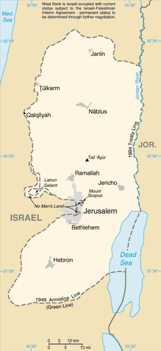






Components and geography
The principal parts are the West Bank — a landlocked territory west of the Jordan River — and the Gaza Strip — a small coastal enclave on the eastern Mediterranean. The West Bank borders Jordan to the east and Israel to the west; the Gaza Strip borders Israel to the north and east and Egypt to the southwest. The region includes varied terrain, from urban centers to agricultural plains and sections of the Dead Sea shoreline.
- West Bank — larger in area, includes cities such as Ramallah, Hebron and parts of Jerusalem.
- Gaza Strip — densely populated, with significant humanitarian and infrastructure challenges.
Historical outline
In the modern era the territories were affected by the wars surrounding the end of the British Mandate and the 1948 Arab–Israeli War, after which the West Bank came under Jordanian control and Gaza was administered by Egypt. During the 1967 Six-Day War, Israel captured both the West Bank and Gaza. Subsequent decades saw military administration, settlement activity, negotiation efforts, and intermittent violence. The 1993 Oslo Accords established the framework for partial Palestinian self-rule and created institutions intended to lead to a negotiated final status.
Key historical references include the role of Jordan and Egypt in the mid-20th century and the 1967 conflict often called the Six-Day War. The Oslo process is commonly referenced under its original name, the Oslo Accords.
Governance and legal status
Governance in the territories is fragmented. Following the Oslo Accords, parts of the territories came under the authority of the Palestinian National Authority (PNA), an interim administrative body. The PNA administers civil affairs and some security responsibilities in areas designated for Palestinian control, while other areas remain under Israeli military or civil authority. East Jerusalem was captured in 1967 and later incorporated into Israeli municipal boundaries; Israel passed laws extending its jurisdiction there, a move not widely recognized by other states.
International recognition and current issues
Palestinian leaders declared an independent State of Palestine in 1988; many countries subsequently granted recognition. The State of Palestine now holds varying degrees of diplomatic recognition internationally. Nonetheless, Israel and some other states, including the United States, have not recognized a fully sovereign Palestinian state as defined in that declaration. Disputes focus on borders, the status of Jerusalem, security arrangements, settlements, refugees, and water and resource rights.
Notable distinctions and present-day realities
Several points help clarify common areas of confusion: the West Bank and Gaza are non-contiguous; governance differs between them; and international law, diplomatic recognition and factual control do not always align. Parts of the West Bank are administered by an Israeli civil authority in areas sometimes referred to in official Israeli terms by other names. The complex mix of local administrations, international actors and ongoing negotiations means the situation remains dynamic and often changes with political developments.
Further context
Understanding the Palestinian territories requires attention to geography, decades of history, and multiple parallel legal and administrative systems. Regional borders and maritime and resource questions, including those related to the Dead Sea, also figure in negotiations. Readers seeking primary documents and diplomatic statements can consult materials linked to major agreements and institutions, including the Oslo Accords, the agencies of neighboring states such as Israel, and regional actors like Jordan and Egypt.
For background on current governance arrangements and humanitarian conditions, sources maintained by international organizations and official statements by the entities involved provide up-to-date information. Key institutional references include the Palestinian National Authority and documentation relating to the Oslo Accords, as well as diplomatic positions regarding recognition of the State of Palestine and the policies of other states such as the United States.
Geography
The West Bank, as a result of the 1995 Interim Agreement on the West Bank and Gaza Strip, was divided into three zones (A: 18%, B: 20%, and C: 62% of the West Bank area), in each of which the Palestinian Authority (PA) and the Israeli military have different powers. The A areas were placed under PA control and consist of the larger cities. The B areas are composed primarily of rural communities and villages. Here the Palestinians have administrative control and Israel has security control. The C area is under Israeli control both civilly and in security matters and consists mainly of sparsely populated rural areas, Palestinian villages and Israeli settlements.
The autonomous territories consist of several settlement areas in the West Bank and the Gaza Strip, separated from each other by the C Area. In addition to Israel and Israeli-occupied areas of the West Bank, they border Egypt and the Mediterranean Sea in the Gaza Strip. The interim agreement provides for the gradual transfer of Zone C territories to Palestinian autonomy, with exceptions yet to be negotiated. No agreement has yet been reached on final status and territorial allocation. Largely within Zone C, Israel has established a fortified perimeter.
Designations
In diplomatic dealings with the Palestinian government, Germany uses the term Palestinian territories for the territory of the autonomous authority. However, because the Israeli-occupied territories in the West Bank and East Jerusalem continue to be seen by the UN as part of the Palestinian Territories, this term also includes areas over which the PA does not exercise direct influence (Zone C, see Geography section). Switzerland uses the term Occupied Palestinian Territory for this in the official context. Austria uses the term Palestine.
Related articles
Author
AlegsaOnline.com Palestinian territories: geography, history, governance, and status Leandro Alegsa
URL: https://en.alegsaonline.com/art/74181