Ottawa: Canada’s capital city, geography, history and cultural life
Overview of Ottawa, the capital of Canada: location, bilingual character, history from Bytown to modern capital, institutions, festivals, neighborhoods, and notable facts.
Overview
Ottawa is the national capital of Canada, located on the south bank of the Ottawa River where the provinces meet. The city sits within the province Ontario and forms part of the broader Eastern Ontario region. Across the river to the north lies the city of Gatineau in Quebec, giving the area an interprovincial character that influences commerce, commuting and culture.
Image gallery
10 Images


Size, language and governance
Ottawa is one of Canada’s largest cities and, as a metropolitan region, is home to roughly one to one and a half million people. It is commonly described as the fourth largest city in Canada and the second largest in Ontario after Toronto. Municipal services in Ottawa are conducted in both English and French; English and French are recognized as official languages in many civic operations, reflecting a substantial francophone minority and the city’s role as a bilingual national capital.
Urban structure and communities
The modern City of Ottawa was formed by amalgamating several municipalities into a single municipal government. Major communities and former cities that now make up Ottawa include suburbs and towns such as Kanata, Nepean, Gloucester and Vanier, together with smaller communities like Manotick, Rockcliffe Park and Orléans; these areas were united in a municipal reorganization completed in 2000. The result is a large, diverse municipality that combines a dense downtown core, federal precinct and market district with extensive residential suburbs and technology business parks.
History and landmarks
The settlement began as a timber and construction town called Bytown and was renamed Ottawa when it incorporated as a city in the mid‑19th century. The location was selected as the permanent seat of government for the Province of Canada and later for the Dominion of Canada in the 1850s; the choice of Ottawa as capital is commonly attributed to a decision formalized in that era. The historic Rideau Canal, built in the early 1800s to link the Ottawa River with the Rideau River and Lake Ontario, terminates in the city and is now a UNESCO World Heritage Site as a recreational waterway and winter skating route.
Culture, festivals and institutions
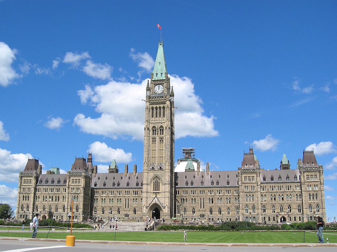
Ottawa is a national centre for museums, galleries and ceremonial government buildings. Parliament Hill anchors the downtown skyline and hosts public ceremonies, while national museums and cultural institutions attract visitors year‑round. The city is known for recurring events such as Winterlude, the annual Tulip Festival, the summer music and arts festival Bluesfest, and the large public observances on Canada Day. A lively market area in the ByWard Market district offers restaurants, shops and street activity through the seasons.
Economy, transport and notable facts
The federal government is a major employer in Ottawa, and the city’s economy also includes technology firms, educational institutions and a growing service sector. Ottawa’s name is often used as an eponym for the national government—people may say "Ottawa decided" when referring to federal policy decisions. Professional sports are part of public life; the NHL club the Ottawa Senators plays its home games at a major suburban arena. The city is connected by regional highways and public transit, including light rail and commuter services, and hosts several universities and research centres that contribute to its bilingual, administrative and cultural character.
- Key attractions: Parliament Hill, Rideau Canal, ByWard Market and national museums.
- Typical annual events: Winterlude (winter), Tulip Festival (spring), Bluesfest (summer), Canada Day celebrations.
- Distinctive features: bilingual municipal services, cross‑river metropolitan partnership with Gatineau, and a mix of government and high‑technology employment.
Geography
Location
The City of Ottawa is located on the south bank of the Ottawa River, at the confluence of the Rideau Canal and Rideau River. From the north, across the urban area of Gatineau, the Rivière Gatineau flows into the Ottawa River. The city of Ottawa is located in the eastern corner of the province of Ontario, and lies at approximately the same latitude as Bordeaux and Venice.
The oldest parts of the city are called Lower Town and are located in the area between the Rideau Canal and Rideau River. On the opposite bank of the canal is Centretown (also called Downtown), the financial and commercial centre of the city. Between Centretown and the Ottawa River is Parliament Hill, the government district. There are several smaller islands in the Ottawa River. In front of one of them are the 60 m wide Chaudière Falls with 15 m drop. Today, the natural waterfalls are also artificially dammed and used to generate electricity. East of the city centre, the Rideau Falls plunge over several cascades into the Ottawa River at the Rideau River, thus forming the estuary. The entire city area is comparatively extensive and covers with 2779 km² an area larger than the area of the Saarland.
Ottawa is bordered by the following Ontario counties: Prescott and Russell United Counties to the east; Stormont, Dundas and Glengarry United Counties to the southeast; the United Counties of Leeds and Grenville to the south; Lanark County to the southwest; and Renfrew County to the west. To the north, it borders the county seat of Gatineau and the regional county municipality of Les Collines-de-l'Outaouais in Quebec. The urban area is surrounded to the south by a greenbelt with a total area of 203.5 km². This was proposed in 1950 by urban planner Jacques Gréber as part of a master plan for the city and implemented by the government starting in 1956.
City breakdown
In 2001, Ottawa (which then had a population of about 350,000) was amalgamated with the previously independent cities of Nepean, Kanata, Gloucester, Rockcliffe Park, Vanier and Cumberland, as well as the rural communities of West Carleton, Osgoode, Rideau and Goulbourn. From 1969 to 2001, the entire current urban area was part of the Regional Municipality of Ottawa-Carleton, which performed individual cross-municipal infrastructure functions. Since the amalgamation, Ottawa's urban area has grown many times over, resulting in 80% of the total area being rural. The city is divided into 23 wards. These in turn are informally subdivided into neighbourhoods.
Although Ottawa and its twin city Gatineau are administratively separate and even located in different provinces, they form together with other smaller municipalities a common metropolitan area with over 1.4 million inhabitants. The official name of this conurbation, which has existed since 1959 and covers 4715 km², is National Capital Region (French: Région de la capitale nationale). Unlike other territorial states, Canada does not have a federal government district; Ottawa's status is the same as that of other non-county cities in the province of Ontario. However, the federal government indirectly influences urban development in the National Capital Region through the National Capital Commission, which manages the buildings and extensive land owned by the federal government.
Tectonics
Most tectonic movements are to be found in western Canada. Nevertheless, slight to moderate earthquakes are also recorded in the eastern part and thus in the region around Ottawa. Canada lies on the comparatively stable North American Plate and thus the east - compared to other parts of the world - has relatively low seismic activity. Each year, about 450 earthquakes are recorded in eastern Canada, of which about four exceed magnitude 4 on the Richter scale.
Eastern Canada is further divided into seismic zones. Ottawa itself is located in the extensive Western Quebec Seismic Zone, which encompasses the entire Ottawa Valley from Montreal to Témiscaming, including the Montreal, Ottawa-Hull and Cornwall urban regions. The patterns of previous earthquakes show a concentration of activity mainly in the two areas along the Ottawa River and on the Montreal-Maniwaki axis.
On September 16, 1732, an earthquake with an estimated magnitude of 5.8 on the Richter scale occurred in Montreal. This caused considerable damage. On November 1, 1935, the strongest quake to date occurred at a magnitude of 6.2, with an epicentre near Témiscaming in the province of Quebec, northwest of Ottawa. On September 5, 1944, a magnitude 5.6 quake with an epicentre near Cornwall, a small town between Ottawa and Montreal, caused about $2 million in damage and collapsed more than 2000 chimneys. Between 1980 and 2000, 16 quakes in Ottawa reached magnitudes above 4.
Climate
Ottawa's climate is a humid continental climate with a wide range and record temperatures (Effective Climate Classification: Dfb). On July 4, 1913, a maximum temperature of 37.8 °C was recorded, whereas on December 29, 1933, the lowest temperature ever recorded was -38.9 °C. Based on this record low temperature, Ottawa is one of the four coldest capitals in the world, after Ulaanbaatar, Nur-Sultan and Moscow. These huge temperature differences allow the city to host a variety of annual events, such as the Winterlude Festival on the frozen Rideau Canal. However, Ottawa's relatively warm summers make it only one of the seven coldest capitals in the world on an annual average basis.
During the winter months, snow and ice dominate. Each year, a total of about 235 cm of snow falls. The largest amount of snow ever recorded in one day was 73 cm on March 2, 1947. The average temperature in January is -10.8 °C with wide variations between day and night temperatures. While daytime temperatures can easily be above zero degrees, nighttime temperatures occasionally drop below -30 °C. In an average winter, the capital is under a blanket of snow from mid-December to early April, although there can be snow-free days around Christmas time. The winter of 2007/08 was particularly productive, with a total of 432.7 cm of snow, just short of the record year of 1970/71 (444.1 cm). High wind chills are common, as is freezing rain. One of these ice storms even caused power outages in January 1998 and severely affected the local economy.
Summers are relatively humid and warm, but last only a relatively short time. The average maximum temperature in July is 26 °C with occasional incursions of cold air with falling humidity from the north of the country. Spring and autumn are correspondingly changeable due to the extremes. Hot days of over 30 °C can occur as early as the beginning of March, but also as late as the end of October. The average rainfall is about 914 mm. The largest amount of rain within one day was measured on September 9, 2004 with 136 mm. In Ottawa the sun shines about 2060 hours a year, which is 47% of the possible sun hours. In summer, tornadoes can also occur.
| Ottawa | ||||||||||||||||||||||||||||||||||||||||||||||||
| Climate diagram | ||||||||||||||||||||||||||||||||||||||||||||||||
| ||||||||||||||||||||||||||||||||||||||||||||||||
| Monthly average temperatures and precipitation for Ottawa
Source: Canadian Climate Normals 1971-2000: Ottawa CDA | |||||||||||||||||||||||||||||||||||||||||||||||||||||||||||||||||||||||||||||||||||||||||||||||||||||||||||||||||||||||||||||||||||||||||||||||||||||||||||||||||||||||||||||||||||||||||||||||||||||||||||||||||||||||||||||||||||||||||||||


History
Early history
Research into early history in the area of the Canadian capital began very late, although as early as 1843 an unknown author dealt with a burial site of 20 Indians in Ottawa, and in 1853 Edward Van Cortlandt with a (different?) burial site. But research, except for the work of Thomas Walter Edwin Sowter around 1900, came to a standstill for more than a century. The trigger for scant discussion was the discovery of a portage and Indian encampment exactly where Canada's National Museum of History and Society now stands. It was not until 2002, on the occasion of the construction of the new War Museum, that intensive exploration of the sites endangered by the construction work began.
The oldest human traces date back some 6500 years and are found at Leamy Lake, but mainly in the Ottawa Valley. The Ottawa, to whom the capital owes its name, came to the Great Lakes from the east in the 14th century. However, they only settled in the region until 1651.
Étienne Brûlé was the first European to navigate the Ottawa River in 1610, and Samuel de Champlain met the Ottawa chief Tessouat near the later city of Ottawa in 1613. He called the inhabitants "Oudaouais." They settled in groups of two or three families in the winter and came together in large hunting parties in the summer. From them the French adopted the snowshoes. At the Chaudière Falls they sacrificed tobacco, as Champlain reports. In 1620 he sent Jean Nicolet to the Kichesipirini, who called the river "Kichesippi" (Great River). Around this time, the Ottawa had managed to establish a trading monopoly along the river. With their canoes they transported furs to the villages of the Wyandot or Hurons, where they were received by the French. In the opposite direction, they transported French trade goods to the more distant tribes. By 1630, the Beaver Wars began a protracted struggle over the fur trade with the Iroquois that set in motion widespread migrations. In 1636 the Kichesipirini unsuccessfully tried to assemble a coalition with Huron, Algonkin, and Nipissing against the Iroquois, who destroyed the Huron and later other tribes around 1650. It was not until the 1700s that some of the groups returned, but the Ottawa remained mostly south of the Great Lakes and thus in what would become the United States. Nevertheless, French fur traders had taken to referring to any Indian from the region of the later capital as "Ottawa," even if it was an Algonkin or Ojibway. Thus, the river called the "Grande Rivière des Algoumequins" soon mistakenly became the "Grande Riviere des Outaouais."
Around Ottawa, on Isle-aux-Allumettes for instance, apart from the two decades or so during which the Ottawa established their trading monopoly, Algonkin groups settled. Champlain called one of these groups "Algoumequins." Their language was a widely used trader's language, so this designation was soon applied to all tribes of this language family. North of Ottawa (near Maniwaki) live today the Kitigan Zibi Anishinabeg, west, at Golden Lake, settle the Algonquins of Pikwàkanagàn First Nation.
In 1759, the area came under British rule. In 1800, Philemon Wright of Massachusetts, the first settler group of five families and 33 workers arrived at Chaudière Falls, which Wright named "Columbia Falls". Wright's Town settlement grew into what is now Gatineau. In 1806, a first raft of 700 logs sailed down the river to Quebec, but it was Napoleon's Continental Blockade, with its high prices, that made these trips a profitable business. Also, Wright, who dominated the town, supplied wheat to the United States beginning in 1812. By 1830 Wright's Town, particularly his company P. Wright & Sons, founded in 1814, had become the most important lumber company in Canada, but at the same time Wright prevented any industry from setting up there for three decades for fear of competition.
The fur trade, after long being carried on by independent hunters and traders, was dominated by the Montreal-based North West Company. It was, however, forcibly merged with the Hudson's Bay Company in 1821, but fur hunting in the Ottawa Valley was now of little importance.
First settlements, city foundation, capital
The name Bytown was first used in 1827 to name the settlement around the construction site of the Rideau Canal. The name was given to Colonel John By, who oversaw the construction of the connecting canal between the Ottawa and Rideau Rivers from 1826 to 1832.
James Johnston established the village's first newspaper, Bytown Independent, in 1836. By 1839, the settlement had a population of 2073. After some controversy, Bytown obtained its city charter in 1850. The town retained the name until 1854; as of January 1, 1855, the town was officially called Ottawa. The first significant industry was lumber, which used the Ottawa to transport huge rafts. Sawmills sprang up at Chaudière and Rideau Falls; J. R. Booth was the most successful of these lumber barons. By 1855, Ottawa had a population of about 10,000. The Rideau Canal brought lumber to Kingston and across Lake Erie to Oswego, an opening of the Canadian forests to the United States that was further expanded by railway construction. Similar to the fur trade, large companies soon displaced family businesses.
On December 31, 1857, Queen Victoria was asked to choose a capital for the province of Canada. (→ History of Canada) She chose Ottawa. Several legends surround the selection. For example, the queen is said to have stuck her hatpin about halfway between the cities of Toronto and Montreal on a map; the closest place was Ottawa. In fact, Ottawa was probably chosen because, on the one hand, it was located on the language border and thus seemed acceptable to both European populations (in Canada today we speak of Euro-Canadians); on the other hand, unlike Toronto, which was close to the border with the United States and might have been easily attacked from Lake Ontario - in the event of another war with the United States - Ottawa was far inland. Barracks Hill, where By had housed its guards, was to become the seat of Parliament. Construction of the building began in 1860, and it was to cost some $4.5 million by 1866. However, it brought construction workers and architects, then numerous administrators and members of Parliament along with their families to Ottawa. The architectural style favoured was the neo-Gothic style popular in Britain at the time.
The Constitution Act of 1867 elevated Ottawa to the capital of the new Canadian federal state. In 1877, the first telephone was presented to the public here. Twelve years later, in 1899, the Ottawa Improvement Commission was created to beautify the city. However, on April 26, 1900, a fire destroyed about 2000 buildings. A faulty chimney in Hull, the old downtown core of Gatineau, caught fire and spread to Ottawa due to weather conditions. Seven people were killed directly by the fire at the time, with more deaths from subsequent epidemics and 15,000 left homeless. On February 3, 1916, another major fire destroyed the Parliament and Senate buildings. The new parliament building was completed in 1922.
Conversion by Jacques Gréber, Cold War
In 1927, the Federal District Commission replaced the commission established in 1899, which also provided for the preservation of the extensive forests in Gatineau Park.
Shortly after the end of the Second World War, the city came to global public attention when on September 5, 1945, Soviet cryptographer Igor Gouzenko defected from the embassy in Ottawa to the Western powers. In the process, he stole 109 secret files on the development of nuclear weapons. At the height of the Cold War, the Diefenbunker was built in Carp, a village west of Ottawa, to protect the government, the administration and the archives. It can be visited today. The bunker was intended to ensure the continued functioning of government activities in the event of an atomic bomb attack, even if the city was completely destroyed.
Since Ottawa was comparatively poorly developed in terms of urban planning, after the establishment of the National Capital Commission in 1959 under the direction of Jacques Gréber, industrial and railway facilities were banned from the inner city area, green spaces were created and cultural life was promoted. This included the centralization of numerous artifacts of Canadian history in a central museum. By 1958, the National Capital Act had already created a capital district of 4800 km² in area, which included 27 towns (municipalities), but mainly Ottawa and Hull.


Questions and answers
Q: What is the population of Ottawa?
A: The city of Ottawa had about 808,391 people in 2004 and the region has about 1,146,790 people.
Q: Who is the mayor of Ottawa?
A: Jim Watson has been the mayor of Ottawa since December 2010.
Q: What languages are official in Ottawa?
A: In Ottawa, both English and French are official languages and have equal status. Every official sign in the city is bilingual as a result.
Q: How did Ottawa become a city?
A: The cities of Ottawa, Kanata, Nepean, Gloucester and Vanier and the villages of Manotick and Rockcliffe Park joined together in 2000 to form the new city of Ottawa. It began with the name Bytown before becoming officially known as "Ottawa" in 1855.
Q: What attractions does Ottawa have?
A: There are many museums, government buildings and parks located throughout the city. There is also a market area downtown where visitors can shop for local goods. Additionally there are several festivals held throughout the year such as Winterlude in February, The Tulip Festival in May, BluesFest during summertime and a large celebration on July 1st for Canada Day. Lastly there is an ice hockey arena called The Canadian Tire Centre which hosts games by The Ottawa Senators team.
Q: Where is it located geographically?
A:Ottawa is part of Ontario province located south of the Ottawa River on its border with Quebec province which it divides with its river namesake.
Related articles
Author
AlegsaOnline.com Ottawa: Canada’s capital city, geography, history and cultural life Leandro Alegsa
URL: https://en.alegsaonline.com/art/73539
Sources
- books.google.com : Britannica Student Encyclopedia
- bookofeverything.com : "Ottawa Book of Everything"
- books.google.com : Downtown Canada: Writing Canadian Cities
- www12.statcan.gc.ca : "Population and dwelling counts, for Canada and census subdivisions (municipalities), 2006 and 2011 censuses – 100% data"
- www12.statcan.gc.ca : "Population and dwelling counts, for Canada, provinces and territories, and urban areas, 2006 and 2001 censuses – 100% data"
- www12.statcan.gc.ca : "Population and dwelling counts, for census metropolitan areas, 2006 and 2011 censuses – 100% data"
- www12.statcan.gc.ca : Census Profile, 2016 Census – Ottawa, Census division
- ottawa.ca : "City of Ottawa – Design C" · web.archive.org
- ottawa.ca : "Rapport au / Report to:"
- brookings.edu : "Global city GDP 2014"
- cbc.ca : "Ottawa shatters annual rainfall record"
- wikidata.org : wikidata.org/wiki/Q1930