Osnabrück
Osnabrück (![]()
![]() [ˌʔɔsnaˈbʁʏk], Westphalian Ossenbrügge, older Platt Osenbrugge, Latin Ansibarium) is a large city in Lower Saxony and the seat of the district of Osnabrück. The independent city is a major centre of Lower Saxony and the centre of the Osnabrück region. With a population of about 165,000 (169,108 according to the municipal population register), it is one of the four largest cities in Lower Saxony, along with Oldenburg, which is of similar size, and the larger cities of Hanover and Braunschweig. The approximately 28,000 students of the university and college make up about 14% of the total population. The exposed location at a junction of old trade routes was the reason for the foundation of the city. In the Middle Ages, Osnabrück was the principal city of the Westphalian quarter of the Hanseatic League.
[ˌʔɔsnaˈbʁʏk], Westphalian Ossenbrügge, older Platt Osenbrugge, Latin Ansibarium) is a large city in Lower Saxony and the seat of the district of Osnabrück. The independent city is a major centre of Lower Saxony and the centre of the Osnabrück region. With a population of about 165,000 (169,108 according to the municipal population register), it is one of the four largest cities in Lower Saxony, along with Oldenburg, which is of similar size, and the larger cities of Hanover and Braunschweig. The approximately 28,000 students of the university and college make up about 14% of the total population. The exposed location at a junction of old trade routes was the reason for the foundation of the city. In the Middle Ages, Osnabrück was the principal city of the Westphalian quarter of the Hanseatic League.
Osnabrück, together with Münster, which is about 50 km away, also became known as the place where the Peace of Westphalia was signed in 1648. According to its own statement, the guiding principle "Peace as a task - committed to peace" still applies in Osnabrück today within the framework of the idea of peace, which determines cultural and political life in the city. This is also made clear by the slogan Osnabrück - The City of Peace, which is used, for example, in the corporate design of the city of Osnabrück.
After the Congress of Vienna, a "de-Westphalianization" began in Osnabrück and the surrounding area (see History of Westphalia). However, Osnabrück's Westphalian character can still be clearly seen in the standard German spoken by the local population, in the architecture in and around Osnabrück, and in the regional cuisine (see Westphalian Cuisine). Unlike the neighbouring district of Osnabrück, the city has not yet joined the Northwest Metropolitan Region. The city is the seat of the Osnabrück diocese, founded in 780.
Today, Osnabrück is still located at the intersection of important European economic axes. As a result, the city has developed into a logistics centre. In addition, a significant automobile, metal and paper industry has settled here.
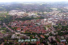
View in east direction over the city centre of Osnabrück
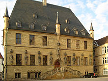
Osnabrück City Hall of the Peace of Westphalia
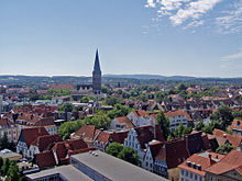
View of the south of the city with the 103 m high Katharinen church
Geography
Geographical location
The city is located in southwestern Lower Saxony on the border with North Rhine-Westphalia, into which Osnabrück extends with the partially surrounding district of Osnabrück. This part of Lower Saxony is enclosed on three sides by North Rhine-Westphalia, with Osnabrück only directly bordering North Rhine-Westphalia on its western side. Osnabrück and the district of Osnabrück together form the region of Osnabrücker Land, which originated from the historical prince-bishopric of Osnabrück. There is a close relationship to the neighbouring Westphalian region of the Tecklenburger Land, both because of the proximity and in a historical context. Thus, Osnabrück is the most important regional centre for the Osnabrücker- and Tecklenburger Land and for other areas in the surrounding area.
Osnabrück lies at the intersection of important European economic axes in north-south and east-west relations. They are visible in the motorway network and the rail network. Due to the traffic development, the city developed into an important logistics centre in the north-western European region.
Neighbouring cities are, clockwise from the north, Oldenburg, Bremen, Hanover, Bielefeld, Dortmund, Münster and Enschede (Netherlands).
Osnabrück is the only major city in Germany to be located in a nature park: The nature and geopark TERRA.vita surrounds the city and extends into the urban area. Osnabrück is located in the Osnabrück Hills, which are bordered by the Wiehen Mountains in the north and the Teutoburg Forest in the south. The foothills directly shape the city, as there are a number of elevations in Osnabrück. The highest is the Piesberg at 188 metres, which is known for its former coal mining and industrial museum. More generally, Osnabrück is located in the Niedersächsisches Bergland (Lower Saxony Uplands), which separates itself from the North German Plain. The elevation at Neumarkt (city centre) is 64 m above sea level. The highest point of the city is at the Piesberg at 188 metres above sea level, the lowest point is at the river Hase in Pye at 54 metres above sea level. The city boundary is 79.5 km long.
North of the Wiehengebirge, the North German Plain begins with the Dümmer-Geestniederung. The Osnabrücker Nordland is characterised by terminal moraines and extensive moor landscapes as well as Geest. South of the Teutoburg Forest there is also a part of the North German Plain, the Westphalian Bay.
Geographical centre of the city
The geographical center of the city is located at latitude 52°16′39″ North, longitude 8°02′51″ East. At the point on the Herrenteichswall, a red sphere was erected on a concrete base in 2016. Right next to the point runs the Hase River with the Haseuferweg. At the midpoint, the Conrad-Bäumer-Weg crosses the Hase and leads to the nearby Gymnasium Carolinum and Osnabrück Cathedral. A plaque at the bridge points to the midpoint.
Geology
Repository search
Already during the first stage of the search for a repository in Germany, large parts of Osnabrück were classified as unsuitable for a nuclear repository. Although there are claystone layers and salt deposits in Osnabrück, these are too shallow or unsuitable due to the numerous geological faults in the Osnabrück uplands. In addition, there are numerous old mining sites in and around Osnabrück, where both hard coal and various ores were mined. Only a small part of Hellern could possibly be examined more closely in the second stage.
Waters
Running waters
The main watercourse in Osnabrück is the Hase together with its tributaries Belmer Bach, Nette and Düte. According to its water management significance, the Hase is a 2nd order watercourse and is not navigable within Osnabrück. It reaches Osnabrück from the east in the direction of Melle in Voxtrup. In the area of Fledder, the right tributary Belmer Bach flows into the Hase, which comes from the eponymous Belm. Shortly afterwards, the Hase splits for about two kilometres into two separate branches, the Klöckner Hase and the Neue Hase. These thus practically form an island, on which the Osnabrück steelworks stood until 1989 and today the Hasepark industrial estate is located. After flowing through the city centre, it picks up the right tributary Nette in the Hafen district. The Nette, which has its source in the Osnabrück Hills, flows from a north-easterly direction through the district of Haste before it flows into the Hase after passing under the branch canal at the Kämmerer paper works. The Hase then flows on to the north-western city boundary at Eversburg. Referring to the river, the city of Osnabrück is also sometimes called Hasestadt.
See also: Öwer de Hase
The Düte flows from the south through the districts of Sutthausen, Hellern and Atter to leave the city of Osnabrück after the Düte bridge at the Attersee and reach the neighbouring Lotte. Further north it flows into the Hase between Wallenhorst and Wersen.
Heavy rainfall caused by low pressure Cathleen led to increased water levels in Osnabrück's flowing waters in August 2010. Flooding occurred in some parts of the city and neighbouring communities, resulting in the declaration of a disaster alert.
Lakes
The two largest lakes in Osnabrück are the Rubbenbruchsee and the Attersee. While the Rubbenbruchsee is mainly used by walkers and joggers for local recreation, the Attersee offers a distinct camping and recreational area and is the only bathing lake in the city area. Both are artificially created quarry lakes.
Smaller still water bodies can be found throughout the urban area, examples being Lake Poplar and Lake Desert in the Wüste district. They often fulfil the function of a rainwater retention basin.
Waterways
In the river valley of the Hase runs parallel to it the Stichkanal Osnabrück, a 14.5 km long artificial federal waterway, which connects the Mittellandkanal near Bramsche with the port in the district of Osnabrück of the same name. The actual canal as a federal waterway is 13.0 km long and ends in the upper outer harbour of the Haste lock, the remaining stretch is counted as part of the Osnabrück city harbour. Further north on the canal are the oil harbour and the Piesberg harbour.
City breakdown
The Osnabrück city area extends over 119.8 km². Officially, 164,748 people live in Osnabrück, which corresponds to a population density of 1375.2 inhabitants per km².
The urban area of Osnabrück is divided into 23 districts, which are numbered consecutively. Their names mostly originate from historically handed down designations or the geographical location. In some cases, several former villages were united to form a single district. Each city district is further subdivided into statistical districts, each of which is designated by a three-digit number. An even smaller division exists with the statistical subdivision into building blocks.
The 23 districts with their official numbers (as of 31 December 2017):
| District number | District name | Area | Inhabitants | p.e./km² |
| 01 | Downtown | 1,71 | 9.561 | 5.590 |
| 02 | West Town | 3,18 | 9.626 | 3.030 |
| 03 | Westerberg | 4,93 | 10.108 | 2.050 |
| 04 | Eversburg | 2,98 | 8.578 | 2.880 |
| 05 | Port | 4,06 | 2.678 | 660 |
| 06 | Sun Hill | 3,19 | 9.371 | 2.950 |
| 07 | Haste | 7,95 | 6.757 | 850 |
| 08 | Dodesheide | 4,49 | 10.108 | 2.260 |
| 09 | Gartlage | 1,44 | 3.729 | 2.590 |
| 10 | Schinkel | 2,33 | 14.410 | 6.180 |
| 11 | Widukindland | 2,76 | 4.965 | 1.810 |
| 12 | Schinkel East | 2,92 | 3.536 | 1.220 |
| 13 | Fledder | 3,75 | 2.594 | 690 |
| 14 | Schölerberg | 3,64 | 14.672 | 4.030 |
| 15 | Lime Hill | 3,02 | 6.298 | 2.090 |
| 16 | Desert | 2,73 | 14.934 | 5.470 |
| 17 | Sutthausen | 4,42 | 4.701 | 1.060 |
| 18 | Hellern | 12,14 | 7.034 | 580 |
| 19 | Atter | 10,67 | 4.306 | 400 |
| 20 | Pye | 7,51 | 2.975 | 400 |
| 21 | Darum/Gretesch/Lüstringen | 14,34 | 8.114 | 570 |
| 22 | Voxtrup | 10,91 | 7.183 | . 0660 |
| 23 | Nahne | 4,75 | 2.268 | 480 |
| Total | 119,80 | 164.374 | 1.410 |
The individual districts have developed their own character over time. While, for example, the city centre, the harbour and Fledder have primarily been home to retail, commerce and industry, Hellern or Widukindland represent classic residential areas with a large proportion of single-family households. West of the city centre, the residential area is more densely populated and characterised by old buildings and rented apartments. While a middle-class clientele has settled in the Westerberg area, Wüste and Weststadt are inhabited by students and younger families and single households. At the city limits, on the other hand, the area is partly rural, Schinkel and Schinkel-Ost as well as Eversburg have been influenced by their history as working-class neighbourhoods.
Land use
The 119.80 km² city of Osnabrück is divided into the following land uses (as of 31 December 2016):
| Type of use | Area in km² |
| total floor area | 119,80 |
| Settlement area | 45,30 |
| Traffic area | 14,63 |
| Agriculture | 37,29 |
| Forest | 19,14 |
| Unland | 0,30 |
| Water surface | 1,80 |
Neighboring communities
Osnabrück is located on the border with North Rhine-Westphalia. Most of the neighbouring municipalities are located in the Osnabrück district of Lower Saxony; the municipality of Lotte is located in the Tecklenburger Land district of North Rhine-Westphalia (Steinfurt district), which is part of the Osnabrück conurbation. As an economic and service centre, Osnabrück has a relatively high commuter balance; over 59 % of employees subject to social insurance commute to work in the city. The Osnabrück conurbation has around 281,000 inhabitants.
|
|
| |
|
|
|
|
|
|
|
Distances are given as the crow flies from the centre of the village to the centre of the village.
Weather and climate
| Osnabrück | ||||||||||||||||||||||||||||||||||||||||||||||||
| Climate diagram | ||||||||||||||||||||||||||||||||||||||||||||||||
| ||||||||||||||||||||||||||||||||||||||||||||||||
| Monthly average temperatures and precipitation for Osnabrück
Source: | |||||||||||||||||||||||||||||||||||||||||||||||||||||||||||||||||||||||||||||||||||||||||||||||||||||||||||||||||||||||||||||||||||||||||||||||||||||||||||||||||||||||||||||||||||||||||||||||||||||||||||||||||||||||||||||||||||||||||||||
Osnabrück lies in the temperate climate zone. The 1900 hectares of forest within the city area are therefore dominated by mixed deciduous forest.
Prevailing are west and northwest winds, which bring cool weather in summer and mild rainy weather in winter. The weather is rather unstable. The average annual temperature is 9.4 °C on a long-term average, with January being the coldest month at 1.8 °C and July the warmest month at an average of 17.6 °C. Winters are somewhat milder than in eastern or southern Germany, but summers are correspondingly cooler, with not only summer thunderstorms but also long periods of rain.
Osnabrück has a relatively high annual precipitation of 856 mm and is above the national average. Winter and summer rainfall are in balance. Overall, the precipitation is distributed over an average of 122 rainy days per year.
Weather stations
- former weather station of the DWD at Ziegenbrink (1952-2010), relocation of the station to Belm in 2010
- Weather data recording by the air monitoring station at Ziegenbrink
- Meteomedia weather station at the Haste campus
- privately operated weather station at the Westerberg
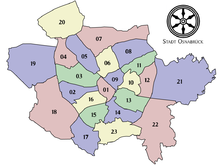
Osnabrück districts with official numbers
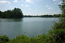
View over the Rubbenbruchsee
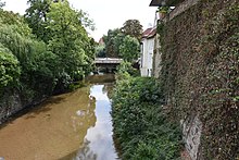
The Hare at the Vitischanze
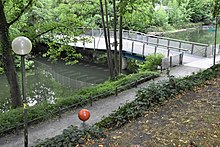
The geographical centre of the city at Herrenteichswall
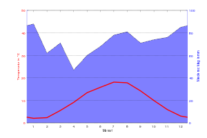
Climate diagram of Osnabrück, 1981 to 2010
Cityscape
The image of the city centre is dominated by churches (tower heights up to 103.5 metres, St. Katharinen). In the northern part of the city centre, between the cathedral Dom St. Peter and Heger Tor, stretches the historic old town with the town hall of the Westphalian Peace. Here you will find many classicist buildings, such as the Tenge House from 1813/1814, as well as rococo buildings and houses from the time when half-timbered houses were still built in the city. One of the half-timbered houses is the Hotel Walhalla, built in 1690.
The triangular market square with the town hall of the Westphalian Peace and the church of St. Marien has a medieval character. In addition, around 150 Romanesque and Gothic stone works have been identified in Osnabrück, many of which are well preserved. That is more than in any other city in Germany, Osnabrück is therefore also called the capital of stone works. Of particular note is the Ledenhof, a stone work with a palace opposite the former baroque palace of the prince-bishops. At the Domhof is the Theater Osnabrück, an Art Nouveau building from 1909. The Lutherkirche in the Südstadt is painted in Art Nouveau style. It was built as a daughter church of the late Gothic hall church of St. Katharinen, the highest church in the city at 103.5 metres. Of historical importance is the former Dominican monastery, whose church is now used as an art gallery.
The pedestrian zone in the middle part of the city centre connects to the old town and forms the main shopping street (Große Straße and the front part of Johannisstraße). Apart from a few buildings that survived the war, modern functional buildings dominate here.
Between the old and new town (southern city centre) is the Neumarkt. Formerly a central market place of the city, it is now cut by a four-lane road and serves as a traffic junction and main bus station. Between 1964 and 2001, pedestrians could not cross Neumarkt at ground level, but had to walk through an underground pedestrian tunnel. This tunnel, called Neumarktpassage, was created to make the city more car-friendly. After it became possible to cross the square above ground again from 2001, the tunnel's importance declined, so that it was closed in 2012 and demolished and backfilled in 2014-16.
North of Neumarkt, in the area of Wittekindstraße and Berliner Platz, companies from the service and financial sectors have settled with modern building structures and glass facades. Neustadt still offers old buildings, especially in the area around the former collegiate church of St. Johann. In the former churchyard of St. Johann stands the listed exhaust column, which ventilates an underground toilet facility. South of the square stands the former Neustadt town hall.
The city centre is enclosed by a kidney-shaped ring road, which accommodates motor traffic. The city's main, entrance and exit roads lead off from this so-called rampart in a star shape. Seven towers, a rampart and two walls line the city ring, which is a remnant of the old city fortifications.
→ Main article: City centre (Osnabrück)
Today's rampart includes, counterclockwise, the Hasetor-, Natruper-Tor-, Heger-Tor-, Schloss-, Johannistor- and Petersburgerwall as well as the Konrad-Adenauer-, Goethe- and Erich-Maria-Remarque-Ring. A combination of old and new is the Vitischanze, where modern architecture has been placed on an old city fortification. Until 2007, part of the casino was housed here. In the meantime, the building was used by the Industrial Design course of the Osnabrück University of Applied Sciences. The tallest building is the Iduna high-rise from the first half of the 1970s with 20 floors.
Green and wooded areas, which also serve as local recreation areas, extend all the way to the city centre. This concept of the "green fingers" was developed in the 1920s by the then city planning councillor Lehmann, who succeeded in ensuring that forest and local recreation areas were preserved from the outside as green lungs extending into the city centre. In the current land use planning, green fingers are also being given further consideration from the point of view of climate protection. Osnabrück is the largest city in Germany to be located in the middle of a nature park, the TERRA.vita Nature and Geopark.
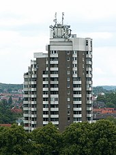
Iduna high-rise
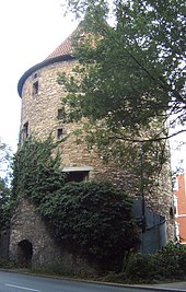
Old city fortification tower civic obedience
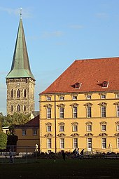
Castle (headquarters of the university) with St. Catherine's Church
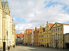
View from the stairs of the town hall
Search within the encyclopedia
.svg.png)