Osaka — Overview, History, Culture and Significance
Osaka is a major Japanese city on Osaka Bay in the Kansai region. A commercial and cultural hub, it is known for its port, cuisine, landmarks, and role as a regional center with 24 wards.
Osaka is the largest city and the administrative capital of Osaka Prefecture. It lies on the coast facing Osaka Bay and the Seto Inland Sea and occupies a central position within the Kansai region of central Japan. Administratively it is a government-designated city divided into 24 wards and functions as a major regional centre for commerce, transport and culture. Since 1980 it has been recognized among the largest cities in Japan and has continued to play a leading role in industry and services.
Image gallery
4 Images


Location, geography and urban layout
The urban area of Osaka spreads across a broad coastal plain with many rivers, canals and reclaimed areas. The city's layout contrasts a dense, high-rise commercial core in districts such as Umeda and Namba with residential suburbs and industrial zones on the periphery. The port facilities on the bay, inland waterways and extensive rail connections integrate the city into domestic and international transport networks.
History and development
Osaka developed over centuries from a regional market town and river port into a national commercial hub. In the late 16th century the construction of prominent fortifications and castles consolidated political and military significance. During the Edo period and the modern era the city became noted for its merchants, marketplaces and manufacturing, shaping a civic character often described as pragmatic and entrepreneurial.
Economy, transport and infrastructure
- Economy: Osaka combines port activity, manufacturing, wholesale trade, finance and a broad service sector. It anchors the economic life of the wider Kansai area.
- Transport: An extensive network of railways, subways, expressways and ports serves daily commuters and freight. Airports in the region link Osaka to domestic and international destinations.
- Urban renewal: Waterfront redevelopment, commercial towers and mixed-use projects continue to reshape parts of the city.
Culture, cuisine and everyday life
Osaka is widely known for its distinctive local food culture, with popular dishes such as takoyaki and okonomiyaki served in restaurants and street stalls. The city has a vibrant entertainment scene, theatres, shopping districts and festivals that reflect both traditional and modern culture. A distinctive dialect, often called Osaka-ben, is commonly heard in informal speech.
Landmarks and institutions
Historic sites, museums, and modern attractions draw visitors and residents alike. Osaka Castle stands as a symbol of the city's historical role, while contemporary cultural facilities, parks and event venues support arts, commerce and leisure. The urban region also hosts universities, research institutes and corporate headquarters that contribute to education and innovation.
Regional context and governance
Osaka acts as the economic and cultural heart of the Kansai region alongside neighbouring prefectures such as Hyōgo Prefecture, Kyoto Prefecture, Nara Prefecture and Wakayama Prefecture. Regional cooperation in transport, tourism and industry links these areas into a broader metropolitan zone with shared challenges in planning, population change and environmental management.
Demographics and social life
As a large city, Osaka displays diverse neighbourhoods and a mix of long-established communities and newer residents. Daily life is shaped by commerce, education and a strong local culture of eating out and social exchange. Civic initiatives, cultural festivals and community organisations play an active role in city life.
Outlook
Osaka continues to evolve as a major urban centre balancing economic activity, cultural vitality and urban sustainability. Efforts to modernize infrastructure, promote tourism and foster international ties aim to maintain its role as a key gateway and hub within Japan and the wider region.
Geography
Osaka is located in the west of the main Japanese island of Honshū at the mouth of the Yodo River, on Osaka Bay. The urban area of Osaka represents just under 12% of the area of the prefecture.
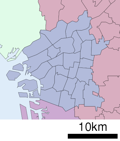
City breakdown
| The districts (-ku) of the city (-shi) of Osaka | |||||||
| Code | Name | Area (in km2) | Population | Population density (Ew./km2) |
| ||
| Rōmaji | 1 January 2021 | 1 March 2021 | 01.10.20153 |
| |||
| 27102-1 | Miyakojima-ku | 都島区 | 6,08 | 107.615 | 104.727 | 17.224,8 |
|
| 27103-9 | Fukushima-ku | 福島区 | 4,67 | 79.695 | 72.484 | 15.521,2 |
|
| 27104-7 | Konohana-ku | 此花区 | 19,28 | 64.713 | 66.656 | 3.462,7 |
|
| 27106-3 | Nishi-ku | 西区 | 5,21 | 105.006 | 92.430 | 17.740,9 |
|
| 27107-1 | Minato-ku | 港区 | 7,86 | 80.206 | 82.035 | 10.437,0 |
|
| 27108-0 | Taishō-ku | 大正区 | 9,43 | 62.015 | 65.141 | 6.907,9 |
|
| 27109-8 | Tennōji-ku | 天王寺区 | 4,84 | 82.478 | 75.729 | 15.646,5 |
|
| 27111-0 | Naniwa-ku | 浪速区 | 4,39 | 76.141 | 69.766 | 15.892,0 |
|
| 27113-6 | Nishi-Yodogawa-ku | 西淀川区 | 14,21 | 96.137 | 95.490 | 6.715,2 |
|
| 27114-4 | Higashi-Yodogawa-ku | 東淀川区 | 13,27 | 176.738 | 175.530 | 13.227,6 |
|
| 27115-2 | Higashinari-ku | 東成区 | 4,54 | 84.182 | 80.563 | 17.745,2 |
|
| 27116-1 | Ikuno-ku | 生野区 | 8,37 | 129.138 | 130.167 | 15.551,6 |
|
| 27117-9 | Asahi-ku | 旭区 | 6,32 | 90.678 | 91.608 | 14.494,9 |
|
| 27118-7 | Jōtō-ku | 城東区 | 8,38 | 167.907 | 164.697 | 19.653,6 |
|
| 27119-5 | Abeno-ku | 阿倍野区 | 5,98 | 111.011 | 107.626 | 17.997,7 |
|
| 27120-9 | Sumiyoshi-ku | 住吉区 | 9,4 | 152.932 | 154.239 | 16.408,4 |
|
| 27121-7 | Higashi-Sumiyoshi-ku | 東住吉区 | 9,75 | 127.196 | 126.299 | 12.953,7 |
|
| 27122-5 | Nishinari-ku | 西成区 | 7,37 | 108.190 | 111.883 | 15.180,9 |
|
| 27123-3 | Yodogawa-ku | 淀川区 | 12,64 | 183.583 | 176.201 | 13.940,0 |
|
| 27124-1 | Tsurumi-ku | 鶴見区 | 8,17 | 111.790 | 111.557 | 13.654,5 |
|
| 27125-0 | Suminoe-ku | 住之江区 | 20,68 | 119.161 | 122.988 | 5.944,3 |
|
| 27126-8 | Hirano-ku | 平野区 | 15,28 | 190.977 | 196.633 | 12.868,7 |
|
| 27127-6 | Kita-ku | 北区 | 10,34 | 139.518 | 123.667 | 11.960,1 |
|
| 27128-4 | Chūō-ku | 中央区 | 8,87 | 104.855 | 93.069 | 10.492,6 |
|
| 27100-4 | Ōsaka-shi | 大阪市 | 225,32 | 2.751.862 | 2.691.185 | 11.944,9 |
|
- On February 13, 1989, Ku Kita (27101-2) and Ōyodo (27112-8, 大淀区) were united to form the new Kita-ku.
- On the same day, the East (27105-5, 東区 Higashi-ku) and South (27110-1, 南区 Minami-ku) districts also merged to form the new Central (Chūō-ku) district.
![]()
Population development of the city
| Data on the day of the census (1 October) | |||||||
| Year | Population | Gender ratio | Area | Population density (Ew./km2) |
| ||
| total | Male | female |
| ||||
| 1920 | 1.252.983 | 673.648 | 579.335 | 116,3 | 58,45 | 21436,8 |
|
| 1925 | 2.114.804 | 1.126.256 | 988.548 | 113,6 | 181,68 | 11640,3 |
|
| 1930 | 2.453.573 | 1.303.862 | 1.149.711 | 113,4 | 185,13 | 13253,2 |
|
| 1935 | 2.989.874 | 1.594.176 | 1.395.698 | 114,2 | 187,33 | 15960,5 |
|
| 1940 | 3.252.340 | 1.691.176 | 1.561.164 | 108,3 | 187,44 | 17351,4 |
|
| 1945 | 1.102.959 | 553.697 | 549.262 | 100,8 | 187,44 | 5884,3 |
|
| 1947 | 1.559.310 | 781.177 | 778.133 | 100,4 | 187,44 | 8319,0 |
|
| 1950 | 1.956.136 | 975.547 | 980.589 | 99,5 | 185,17 | 10564,0 |
|
| 1955 | 2.547.316 | 1.281.416 | 1.265.900 | 101,2 | 202,31 | 12591,2 |
|
| 1960 | 3.011.563 | 1.542.833 | 1.468.730 | 105.0 | 202,18 | 14895,5 |
|
| 1965 | 3.156.222 | 1.598.376 | 1.557.846 | 102,6 | 203,04 | 15544,8 |
|
| 1970 | 2.980.487 | 1.490.779 | 1.489.708 | 100,1 | 205,60 | 14496,5 |
|
| 1975 | 2.778.987 | 1.378.287 | 1.400.700 | 98,4 | 208,11 | 13353,5 |
|
| 1980 | 2.648.180 | 1.304.599 | 1.343.581 | 97,1 | 210,95 | 12553,6 |
|
| 1985 | 2.636.249 | 1.295.771 | 1.340.478 | 96,7 | 213,08 | 12372,1 |
|
| 1990 | 2.623.801 | 1.292.747 | 1.331.054 | 97,1 | 220,37 | 11906,3 |
|
| 1995 | 2.602.421 | 1.278.212 | 1.324.209 | 96,5 | 220,66 | 11793,8 |
|
| 2000 | 2.598.774 | 1.273.121 | 1.325.653 | 96,0 | 221,30 | 11743,2 |
|
| 2005 | 2.628.811 | 1.280.325 | 1.348.486 | 94,9 | 222,11 | 11835,6 |
|
| 2010 | 2.665.314 | 1.293.798 | 1.371.516 | 94,3 | 222,47 | 11980,6 |
|
| 2015 | 2.691.185 | 1.302.562 | 1.388.623 | 93,8 | 225,21 | 11949,7 |
|

History
The city of Osaka was originally called Naniwa. The city was the capital of Japan as Naniwa no miyako or Naniwa-kyō (難波京, Eng. "Imperial Residence City of Naniwa") from 645 to 655 under the Kōtoku-tennō and lastly in 744 under Shōmu-tennō. However, Naniwa was probably also the seat of earlier Tennō, e.g. the Nihonshoki mentions that the Ōjin-tennō (r. 270-310) moved into the Ōsumi Palace (大隅宮, Ōsumi no miya) in Naniwa.
There have been important land and sea links between Yamato (now Nara Prefecture), Korea and China since earliest times. The former Settsu Province now forms the northern part of Osaka Prefecture with part of what is now Hyōgo Prefecture.
The Jōdo-Shinshū Buddhist religious community established its headquarters in Ishiyama (now part of Osaka) in 1496 in the heavily fortified temple of Ishiyama Hongan-ji. Oda Nobunaga began a siege of the temple in 1576 that lasted four years. The monks surrendered in 1580, the temple was completely destroyed and Toyotomi Hideyoshi built his own castle, Ōsaka Castle, on the site.
Osaka was called Ōzaka (大坂) from the Middle Ages until pre-modern times. At the beginning of the Meiji period, the city was renamed by the government to its present name Osaka. Nowadays, Osaka is the third largest Japanese city after Tokyo and Yokohama, and the most important in terms of goods economy, as the main markets for the exchange of goods are located there.
Since the Meiji Restoration, the Osaka City Prefecture (-fu) has existed as the successor to the Shōgunat administration for the city (Ōsaka-machi-bugyō), initially consisting only of the city of Osaka, but soon expanded to include areas in Settsu Province, and later Izumi, Kawachi, and Yamato provinces. The precursors of the modern city of Osaka, the four city counties/districts (-ku) of Higashi (east), Nishi (west), Kita (north), and Minami (south) were carved out of the counties (-gun) of Higashinari and Nishinari in 1878/79. When the municipal codes were modernized in 1888/89, they became the modern Ōsaka-shi, which, however, like Tokyo and Kyōto, remained without an independent municipal government until 1898 after the exemption from the municipal code (shisei tokurei) enacted at the same time, and as an immediati city was governed directly by the prefectural governor. By 1955, Higashinari and Nishinari counties had been fully incorporated into the city of Osaka, along with parts of other counties, in several stages, including a major expansion in 1925. In the 1920s, the population thus exceeded that of the city of Tokyo, and Osaka was for a time the largest city in Japan until, again in 1932, Tokyo more than doubled its population through extensive incorporations ("Greater Tokyo"). From 1922, the city of Osaka was one of the six major cities with slightly more self-government or reduced powers of intervention by the Imperial Ministry of the Interior/prefectural governor. During the occupation period, self-government was reformed as in all municipalities and prefectures, and a municipal police force (Ōsaka-shi Keishi-chō) also existed until 1954. As a "special city" (tokubetsu-shi), Ōsaka-shi was supposed to become a prefecture-independent major city, but this was never implemented; instead, it became one of the first five major cities by ordinance (seirei shitei toshi) with expanded self-government in 1956. Since a reorganization in 1989, the current 24 municipal districts exist.
During World War II, the city was bombed several times with napalm bombs by the United States Army Air Forces (USAAF) between March 1945 and August 1945. The attacks destroyed about 35% of the city area and caused 12,620 deaths and 23,037 injuries. The raids burned 40 km2 of the city and left 1,134,552 people homeless (see Air Raids on Osaka).
In 2019, the G20 summit was held in Osaka. The topics discussed included the economy within the group of states.
Questions and answers
Q: What is Osaka?
A: Osaka is the capital city of Osaka Prefecture in Japan.
Q: What bodies of water does Osaka face?
A: Osaka faces Osaka Bay and the Seto Inland Sea.
Q: Where is Osaka located?
A: Osaka is in the Kansai region of Japan.
Q: What is the significance of Osaka in the Kansai region?
A: Osaka is the economic and cultural center of the Kansai region.
Q: What is the population ranking of Osaka in Japan?
A: Since 1980, Osaka has been the second largest city in Japan.
Q: How is Osaka separated administratively?
A: Osaka is designated by government ordinance in Japan and separated into 24 wards.
Q: What are the neighboring prefectures of Osaka?
A: Osaka is surrounded by Hyōgo Prefecture, Kyoto Prefecture, Nara Prefecture, and Wakayama Prefecture.
Related articles
Author
AlegsaOnline.com Osaka — Overview, History, Culture and Significance Leandro Alegsa
URL: https://en.alegsaonline.com/art/73309
Sources
- books.google.com : "Ōsaka"
- escholarship.org : "From Shrinking Cities to Toshi no Shukushō: Identifying Patterns of Urban Shrinkage in the Osaka Metropolitan Area,"