
Oregon Territory (U.S. organized territory, 1848–1859)
Former organized U.S. territory created from the southern Oregon Country in 1848; later subdivided into states and territories including Oregon and Washington and reconfigured through the 1860s.
Overview
The Oregon Territory was the organized territorial government established by the United States on August 14, 1848, from the portion of the Pacific Northwest that had been subject to Anglo‑American contention during the first half of the 19th century. Prior to formal organization, the wider region was often called the Oregon Country and had been occupied for decades by Indigenous peoples, traders, missionaries and settlers under a period of joint Anglo‑American occupancy and competing claims. The international dispute between the United States and Britain was largely resolved by the Oregon Treaty of 1846, which fixed the international boundary near the 49th parallel and allowed the United States to proceed with a territorial government.

Image gallery
8 Images



Geography and jurisdiction
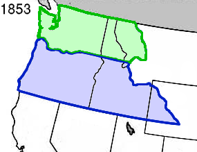
When Congress passed the enabling legislation in 1848, the Territory of Oregon encompassed a vast area in the modern Pacific Northwest. It included what are now the states of Idaho, Oregon and Washington, as well as parts of Montana and Wyoming on the western side of the Continental Divide, extending south to the 42nd parallel—the northern border of the Mexican Cession. The Columbia River and its lower reaches were central geographic features and transportation arteries for the territory's economy and settlement. The large size and sparse population posed administrative challenges that led to later subdivision.

Government, capitals, and settlement
The federal act that created the territory provided for a governor, judges, and a territorial legislature, establishing civil government where settlers had previously relied on provisional institutions. Early administrative life centered at Oregon City, which served as the initial territorial capital before the seat of government moved to Salem in 1851. Settlement accelerated in the 1840s and 1850s via overland migration trails and river routes; federal measures such as land laws and other incentives encouraged American settlers to claim and develop farms and towns in the region.
Partition, statehood, and later changes
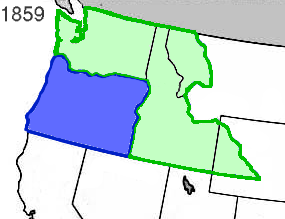
Growing population and political organization produced further territorial adjustments. In 1853 the northern portion was detached to form the Washington Territory, reducing the size of Oregon Territory and clarifying jurisdiction north of the Columbia and a portion of the interior. On February 14, 1859, the reduced Oregon Territory was admitted to the Union as the State of Oregon in its present western boundaries. Land east of the new state line was reassigned—some areas were folded into the Washington Territory, and later reorganizations in 1861 and 1863 placed parts into the Nebraska Territory and the Idaho Territory respectively—reflecting the rapid administrative evolution of the trans‑mountain West.
Importance and legacy
The Oregon Territory era is significant for several intersecting reasons: it resolved a major diplomatic boundary dispute between world powers, it accelerated American expansion and settlement across the continent under themes associated with Manifest Destiny, and it set patterns of land policy, transportation development, and relations with Indigenous nations that shaped the region. The political institutions and communities established during the territorial period provided the foundations for state governance, commerce, and later economic development in the Pacific Northwest.
Key points and timeline
- Early 19th century: region known as the Oregon Country under joint British‑American influence.
- 1846: the Anglo‑American agreement fixed the international boundary near the 49th parallel.
- 1848: Congress organized the U.S. portion as the Territory of Oregon.
- 1853: northern areas formed the Washington Territory.
- 1859: the State of Oregon admitted to the Union; remaining eastern lands reassigned and later reorganized into other territories.
For additional administrative details, legislative records and cartographic depictions from the period, consult historical compilations and primary documents held by national and regional archives or referenced collections: the act of Congress establishing the territory and subsequent congressional measures remain central sources for the territory's legal history. Territorial act and contemporary accounts supply much of the documentary record used by historians and archivists.

Further reading and resources are available through national libraries, state historical societies and curated online collections that preserve maps, reports and correspondence from the territorial era; these collections also clarify the interactions among settlers, Indigenous nations and federal authorities that shaped the territory's development.

See also
- Oregon Country
- Oregon Contract
Questions and answers
Q: What was the original name of the unorganized Oregon Country?
A: The original name of the unorganized Oregon Country was the Oregon Territory.
Q: When did the two countries agree to split this territory?
A: The two countries agreed to split this territory in 1846.
Q: When was the U.S. portion of the Oregon Country organized into a territory?
A: The U.S. portion of the Oregon Country was organized into a territory on August 14, 1848.
Q: What states were originally included in the Oregon Territory?
A: The states originally included in the Oregon Territory were Idaho, Oregon and Washington, as well as Montana west of the Continental Divide and Wyoming west of the Continental Divide and north of 42nd parallel north—the northern border of Mexican Cession.
Q: Where was the first territorial capital located?
A: The first territorial capital was located in Oregon City.
Q: When did part of what is now Idaho and western Wyoming become part Nebraska Territory and Idaho Territory respectively? A: Part what is now Idaho and western Wyoming became part Nebraska Territory and Idaho Territory respectively in 1861 and 1863 respectively.
Q: When did all parts that made up what is now known as "Oregon" enter Union as a state? A: All parts that made up what is now known as "Oregon" entered Union as a state on February 14, 1859
Related articles
Author
AlegsaOnline.com Oregon Territory (U.S. organized territory, 1848–1859) Leandro Alegsa
URL: https://en.alegsaonline.com/art/73067