Ore Mountains (Erzgebirge / Krušné hory): geography, mining and cultural heritage
A concise overview of the Ore Mountains on the Germany–Czech border: geography, mining history, traditional crafts, Christmas folk art and modern tourism.
Overview
The Ore Mountains are a mid‑elevation range along the border of Germany and the Czech Republic. Known in German as the Erzgebirge and in Czech as the Krušné hory, the range stretches roughly where the western edge of Saxony meets the valley of the Elbe. For a long distance the chain forms the international frontier and has been shaped by both natural processes and centuries of human industry. The region takes its common English name from the abundance of metal ores that were historically mined there.
Image gallery
10 Images


Geography and natural features
The landscape is a sequence of rounded ridges, plateaus and deep valleys carved by streams and glacial action. Prominent summits include well known peaks such as Fichtelberg and Klínovec, which anchor the highest parts of the range. Vegetation is typical of central European highlands, with mixed forests, moorlands on the higher summits and agricultural lower slopes. The range's geology is complex: metamorphic and igneous rocks host veins of metals that attracted mining from medieval times onwards.
Mining history and heritage
Mining transformed the Ore Mountains from the Middle Ages into an industrial heartland. Prospectors and miners extracted veins of silver, tin and other metals, reshaping settlements and creating a dense network of shafts, adits and waterworks. As deposits dwindled, the local economy adapted: former miners turned to crafts and small industry. Today the mining landscape, with its galleries, smelters and water-management systems, is recognized for its historical value and parts have been protected through heritage programs and international designations.
Cultural traditions and craft industries
The social legacy of mining is especially visible in local customs and handicrafts. When ore production fell, many families supplemented their income through textile work such as lace making, weaving, and by taking up wood carving. These skills evolved into a distinctive folk art: carved nutcrackers, seated "smoking men" (figure incense burners), multi‑tiered Christmas "pyramids" and illuminated window arches known as Schwibbogen are typical products. Towns such as Seiffen became renowned centres of the wooden toy and craft trade; the region's decorative traditions are now associated with Christmas markets across central Europe. Examples of typical items include:
- Nutcrackers: decorative carved figures derived from miners and local characters.
- Smoking men (Räuchermännchen): small carved figures designed to hold incense cones.
- Pyramids and Schwibbogen: wooden carousels and window arches often illustrating mining scenes or nativity figures.
Modern economy and tourism
After industrial decline the area diversified into forestry, light manufacturing, and tourism. Its winter sports facilities, hiking trails, and cultural museums draw visitors interested in both natural scenery and intangible heritage. Local museums present mining technology and daily life of miners, while craft workshops continue traditional production for visitors and export. Cross‑border cooperation has increasingly highlighted the shared history and conservation of the mining landscape.
Notable distinctions and further resources
The Ore Mountains are notable for the long continuity between extractive industry and village crafts, and for the way a mining economy produced distinctive cultural expressions now celebrated during the winter season. For more specific information and source material about names, maps and crafts, see regional pages and cultural collections: geography and maps, Saxony, historic mines, and the region's continuing artisan industries such as the wooden toy trade. Additional cultural context and craft techniques can be explored via links on local heritage sites and museum portals: Erzgebirge overview, Krušné hory overview, and thematic entries on mining, folklore and crafts: ore deposits, silver history, tin history, and traditional handicrafts such as lace and wood carving.
This article summarizes the region's geography, the history of its mining economy, and the distinctive crafts and traditions that developed in response to changing economic circumstances.
Natural area classification
There is no valid natural area classification for the entire Ore Mountains, as the definition and characterization of natural areas is carried out by the states and federal provinces, so that the Ore Mountains have different classifications for the Saxon and Czech parts. However, the western and eastern boundaries are largely aligned. The total area is about 5262 km².
Saxon Ore Mountains
The most detailed natural spatial classification of Saxony, and thus also of the Saxon Ore Mountains, was drawn up between 1965 and 2007 by the "Naturhaushalt und Gebietscharakter" (Nature balance and area character) working group of the Saxon Academy of Sciences in Leipzig. This subdivides Saxony into geochores, which are called micro-, meso- and macrogeochores with increasing aggregation of uniform areas. An independent natural area designation "Erzgebirge" is not held out there, but the macrogeochores Westerzgebirge, Mittleres Erzgebirge and Osterzgebirge. The boundaries between these are formed by the slopes of the deeply incised rivers Schwarzwasser / Zwickauer Mulde (between the Western and Middle Ore Mountains) and the Flöha (between the Middle and Eastern Ore Mountains). Together with the natural regions Vogtland, Elstergebirge, Sächsische Schweiz, Oberlausitzer Bergland and Zittauer Gebirge these three form the natural region Sächsisches Bergland und Mittelgebirge. The adjacent natural regions are from west to east: Vogtland, Erzgebirgsbecken, Mulde-Lösshügelland, Östliches Erzgebirgsvorland and Sächsische Schweiz. The three Erzgebirge macrogeochores are divided into a total of 51 mesogeochores and 318 microgeochores. The total area of the Saxon Ore Mountains is 3655.45 km².
| Macrogeochore | Area [km²] | Mesogeochores | Microgeochores [number] |
| Westerzgebirge | 777,64 | Auer valley basin with ridges, Bockau plateau, Eibenstock ridge, northwest ridge of the Ore Mountains, west ridge of the Ore Mountains near Auerbach, west ridge of the Ore Mountains near Markneukirchen, west ridge of the Ore Mountains near Schöneck, high and ridge areas around the Auersberg and Aschberg, high areas near Schöneck, high areas near Schneeberg, Kirchberger Becken, Kuhberg-Steinberg-Rückenland, Schönheider Hochflächen, Klingenthaler Bergrücken, Hartensteiner Muldeland | 86 |
| Middle Ore Mountains | 1383,26 | Flöhatal, Grünhainer Hochfläche, Geyerscher Wald, highlands and ridges around the Fichtelberg, Marienberger Hochflächen, high ridges near Annaberg-Buchholz, high ridges near Lengefeld, high ridges at the upper Preßnitz, slope at the Schwarzwasser, high plains around Scheibenberg, ridge high plains near Kühnhaide, Stollberg north ridge of the Erzgebirge, north ridge of the Erzgebirge near Chemnitz, Thumer high ridge, Wolkensteiner Riedelland, Zwönitzer high plains, Zschopauer Riedelland, Zwönitz valley | 109 |
| Eastern Erzgebirge | 1494,55 | Dippoldiswalder Riedelland, Frauensteiner Hochflächen and Riedel, Freiberg and Oederaner Hochflächen, Muldeland near Lichtenberg, Muldeland near Nassau, Hoch- und Kammlagen around the Kahleberg, Hoch- und Kammlagen near Seiffen, Hochflächen near Rechenberg-Bienenmühle, highland ridges near Schmiedeberg, ridge country near Lengefeld, Sayda ridge and ridge country, Tharandt Forest, valley of the Wild Weisseritz, slopes near Kipsdorf and Bärenstein, Reinhardtsgrimma highlands, Liebstädter ridge country, Fürstenau-Oelsen highlands, highlands near Glashütte | 123 |
See also: List of natural units in Saxony
The Saxon State Office for the Environment, Agriculture and Geology chooses a different aggregation of microgeochores for the preparation of land use plans and divides the Ore Mountains into six landscapes by introducing an altitudinal grading in each case.
| Landscape | Area (km²) |
| Lower Westerzgebirge | 276,12 |
| Upper Westerzgebirge | 509,10 |
| Lower Middle Ore Mountains | 1038,57 |
| Upper Middle Ore Mountains | 341,80 |
| Lower Osterzgebirge | 1256,71 |
| Upper Osterzgebirge | 236,58 |
In the older natural classification of Germany of the former Federal Institute for Regional Geography, which was published between 1953 and 1962 and considered the whole of Germany as well as neighbouring areas, the Ore Mountains represent the main unit group 42 with five subdivisions. However, no mapping was done, only a description of the natural areas. The border between upper and lower Westerzgebirge on the one hand and upper and lower Osterzgebirge on the other hand was also formed by the river Flöha, so that in this subdivision the border of the Westerzgebirge was clearly further east. This subdivision was simplified for the evaluation of protection purposes (FFH areas, nature reserves) by the Federal Agency for Nature Conservation in 1994. The subdivisions were merged, but the Erzgebirge remained a main unit group under the key D16 with practically unchanged boundaries. The Federal Agency for Nature Conservation has further subdivided these and issues corresponding fact sheets for the individual areas.
| Federal Institute for Regional Geography | Federal Agency for Nature Conservation | |||
| Key | Name | Key | Name | Area [km²] |
| 420 | southern slope of the Erzgebirge | 42000 | southern slope of the Erzgebirge | 73 |
| 421 | Upper Westerzgebirge | 42100 | Upper sites on the northern slopes of the Western and Central Ore Mountains | 698 |
| 42101 | Lower layers of the Westerzgebirge | 270 | ||
| 422 | Upper Osterzgebirge | 42200 | Upper reaches of the Osterzgebirge mountains | 327 |
| 423 | Lower Westerzgebirge | 42300 | Lower layers of the Middle Ore Mountains | 1087 |
| 424 | Lower Osterzgebirge | 42400 | Lower layers of the Osterzgebirge mountains | 1285 |
Krušné hory
The Geomorphological Classification of the Czech Republic divides the Czech territory into a total of ten hierarchical levels. This classification is based less on landscape and natural aspects and more on geomorphology, i.e. relief. The unit corresponding to the Bohemian Ore Mountains is called Krušné hory, as is the Czech name for the entire Ore Mountains. This main unit forms the 6th level of the classification with 92 others, which usually include natural landscapes. Superordinate are:
Hercinský systém → Hercynská pohoří ("Heartynids") → Česká vysočina (Bohemian Mass) → Šumavská subprovinice → Krušnohorská subprovincie → Krušnohorská hornatina.
Krusne hory borders from east to west on the following main geomorphological units: Děčínská vrchovina (Bohemian Switzerland), Mostecká pánev (North Bohemian Basin), Doupovské hory (Doupov Mountains), Sokolovská pánev (Falkenau Basin) and Chebská pánev (Cheb Basin).
The subordinate units are:
| Podcelek (subunit) | Area [km²] | Okrsek (district) | Podokrsek (subdistrict) | Mountains |
| Klínovecká hornatina | 775 | Přebuzská hornatina (Early Buss-Neudek Mountains) | Rolavská vrchovina, Kraslická hornatina, Hamerská hornatina, Zaječická hornatina | Zaječí hora (Rammelsberg, 1010 m), Tisovský vrch (Peindlberg, 977 m), Jeřábí vrch (Stangenhöhe, 965 m) |
| Jáchymovská hornatina | Božídarská hornatina, Abertamská hornatina, Vykmanovská hornatina, Českohamerská hornatina | Klínovec (Wedge Mountain, 1244 m), Božídarský Špičák (Gottesgab Spire Mountain, 1115 m), Tetřeví hora (Rooster Mountain, 1006 m) | ||
| Jindřichovická vrchovina | Bublavská vrchovina, Olovská vrchovina, Nejdecká vrchovina | Počátecký vrch (Origin Mountain, 819 m) | ||
| Krajkovská pahorkatina | without | K Rozhledne (625 m) | ||
| Loučenská hornatina | 832 | Přísečnická hornatina | Vejprtská vrchovina, Jelenohorská vrchovina, Prísecnická kotlina, Medenecká hornatina, Novodomská hornatina | Jelení hora (Hass Hill, 994 m), Velký Špičák (Big Spitz Hill, 965 m), Mědník (Copper Hill, 910 m) |
| Rudolická hornatina (Bear Stone Mountains) | Nacetínská vrchovina, Brandovská vrchovina, Mezihorská hornatina | Medvědí skála (Bear Stone, 924 m), Čihadlo (Lauschhübel, 842 m) | ||
| Novoveská hornatina | without | Mračný vrch (Göhrenberg, 852 m) | ||
| Flájská hornatina, Meziborská hornatina, Novomestská hornatina | Moldavská vrchovina (Wieselstein Mountains) | Loučná (Wieselstein, 956 m), Oldřišský vrch (Walterberg, 878 m) | ||
| Cínovecká hornatina (Bornhauer Mountains) | without | Pramenáč (Bornhau Mountain, 909 m) | ||
| Nakléřovská vrchovina | Telnická hornatina, Petrovická vrchovina | Rudný vrch (Zechberg, 796 m); Špičák (Sattelberg, 723 m) | ||
| Bolebořská vrchovina | Místecká vrchovina, Brezenecká vrchovina | Pavlovský Špičák (695 m) |


Topographical description
Area, neighbouring landscapes and boundaries
The Ore Mountains are about 150 km long in (south-)west-(north-)east direction and 40 km wide on average. From a geomorphological point of view it is divided into Western, Central and Eastern Ore Mountains, separated by the valleys of Schwarzwasser and Zwickauer Mulde resp. Flöha ("Flöhalinie"), whereas the division of the western part along the Schwarzwasser is more recent. The Osterzgebirge is mainly characterized by extensive, slowly rising plateaus, which are smaller in the more indented and higher reaching central and western part and are also intersected by more frequently changing direction valleys. The ridge of the mountain itself forms, in all three segments, a succession of plateaus and individual mountains.
To the east are the Elbe Sandstone Mountains, to the west the Elster Mountains and other Saxon parts of the Vogtland. South (east) of the Central and Eastern Ore Mountains lies the North Bohemian Basin, immediately east of which is the Bohemian Central Upland, separated from the Eastern Ore Mountains by narrow foothills of the above-mentioned basin. South (east) of the Westerzgebirge lie the Falkenau Basin, the Egergraben and the Duppau Mountains. To the north the border is blurred, because the Erzgebirge, as a typical representative of the Pultschollengebirge, slopes very flat.
The transition zone between the western and central Erzgebirge mountains and the loess hill country to the north between Zwickau and Chemnitz is known as the Erzgebirge basin, while the area north of the Osterzgebirge mountains is known as the Erzgebirge foreland. The Erzgebirge foreland between Freital and Pirna is called the Dresden Erzgebirge foreland or the Bannewitz-Possendorf-Burkhardswalder plateau. Geologically, the Ore Mountains extend to the city limits of Dresden with the Windberg near Freital and the Karsdorf Fault. The notch valleys of the Osterzgebirge break through this fault and the valley shoulder of the Elbe basin.
Within the low mountain range threshold, the Ore Mountains belong on the one hand to the mountain range called Bohemian Mass, which also consists of the Upper Palatinate Forest, Bohemian Forest, Bavarian Forest, Lusatian Mountains, Jizera Mountains, Giant Mountains and the inner Bohemian Mountains. Likewise, with the Upper Palatinate Forest, Bohemian Forest, Bavarian Forest, Fichtelgebirge, Franconian Forest, Thuringian Slate Mountains and Thuringian Forest, it forms a ypsilon-shaped mountain complex which, although it does not have its own name, is to be assessed climatically quite uniformly.
Following the tradition of the cultural areas, Zwickau historically still belongs to the Erzgebirge, Chemnitz lies in an analogous way historically just outside and Freiberg is again included. The presumed border of the Erzgebirge runs further southwest of Dresden towards the Elbe Sandstone Mountains. The main character, i.e. flat plateaus rising to the ridge and incisive valleys, continues to the southern edge of the Elbe basin. North of the Erzgebirge, the landscape gradually changes into the Saxon Loess Gefilde. The cultural transition to the Elbe Sandstone Mountains is very blurred at the height of the Müglitz and Gottleuba valleys.
Remarkable surveys
→ Main article: List of mountains in the Ore Mountains
The highest mountain in the Ore Mountains is Klínovec (Keilberg) at 1,244 metres in the Bohemian part of the mountains. The highest elevation on the German side and at the same time the highest mountain in Saxony is the 1,215-meter-high Fichtelberg. In the Ore Mountains there are about thirty elevations with a height of more than 1,000 meters above sea level, but not all of them are prominent mountains. Most are found around the Keilberg and the Fichtelberg. About a third of them are on the Saxon side.
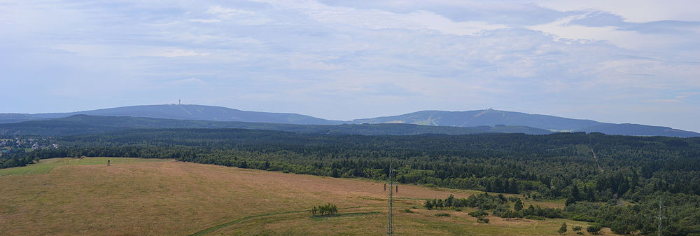
enlarge and show information about the picture
![]()
The peaks of Klínovec and Fichtelberg (from the left), which clearly tower above the other elevations of the mountain range, as seen from Mědník, about 10 kilometres away.


Questions and answers
Q: Where are the Ore Mountains located?
A: The Ore Mountains are located in Germany and the Czech Republic.
Q: What is the length of the border formed by the Ore Mountains between Germany and the Czech Republic?
A: The border formed by the Ore Mountains between Germany and the Czech Republic is 150 km long.
Q: Why are the Ore Mountains named so?
A: The Ore Mountains are named because of their plentiful metal ores.
Q: What are the famous Christmas traditions associated with the Ore Mountains?
A: The Ore Mountains are famous for many Christmas traditions such as wood carving, making nutcrackers, smoking men, pyramids, and Schwibbogen.
Q: What did former miners in the Ore Mountains do when they could not find silver and tin any more in the mines?
A: Former miners in the Ore Mountains looked for new ways to feed their families and went into wood carving, lace making, and weaving.
Q: Which town in the East Ore Mountains was a centre of the wooden toy industry?
A: Seiffen in the East Ore Mountains was a centre of the wooden toy industry.
Q: What do Schwibbogen symbolise?
A: Schwibbogen symbolise the opening of a mine and are wooden arcs with candles in the windows.
Related articles
Author
AlegsaOnline.com Ore Mountains (Erzgebirge / Krušné hory): geography, mining and cultural heritage Leandro Alegsa
URL: https://en.alegsaonline.com/art/73051